
INSIGHTS
AI Aerial Image Analysis: Transforming Raw Data into Engineering Intelligence
The transition from visual data collection to actionable engineering intelligence represents the most significant shift in modern asset management. While the deployment of autonomous systems has simplified the acquisition of high-resolution imagery, the resulting data volume often exceeds the processing capacity of traditional human-centric workflows. Implementing AI aerial image analysis is no longer an optional enhancement but a technical necessity for organizations seeking to eliminate manual data processing bottlenecks and human error in feature identification. Professional asset managers recognize that raw pixels don't constitute evidence; they require a systematic framework for validation and analysis to ensure long-term infrastructure integrity.
This article details how AI-driven geospatial analytics converts high-resolution aerial imagery into actionable engineering insights for enterprise asset management. You'll discover the specific mechanisms that allow these platforms to bridge the gap between raw data and engineering confidence. We'll examine the technical methodologies that enable reduced inspection costs, predictive maintenance capabilities, and the generation of high-confidence documentation required for rigorous regulatory compliance. By aligning technological capabilities with strategic industrial applications, organizations can finally achieve the repeatable, evidence-based data necessary for comprehensive oversight and lifecycle management.
Key Takeaways
Analyze the fundamental shift from manual data interpretation to autonomous feature extraction as a prerequisite for enterprise level scalability.
Utilize AI aerial image analysis to deploy sophisticated change detection algorithms that identify structural degradation and erosion with mathematical precision.
Implement automated verification protocols to compare as-built infrastructure against original design specifications for enhanced engineering confidence.
Secure a repeatable, evidence-based reporting framework that transforms raw geospatial captures into high-fidelity intelligence for regulatory compliance.
The Paradigm Shift: Defining AI Aerial Image Analysis in Enterprise Engineering
AI aerial image analysis constitutes the algorithmic processing of drone-acquired geospatial data through sophisticated computer vision and deep learning architectures. This methodology facilitates the conversion of raw, unstructured imagery into high-fidelity engineering intelligence, moving beyond the limitations of qualitative visual records. Precision is now automated. For enterprise entities, the implementation of these automated workflows is a strategic necessity to manage the massive datasets produced by high-frequency aerial inspections, ensuring that every pixel contributes to a verifiable data-to-decision pipeline.
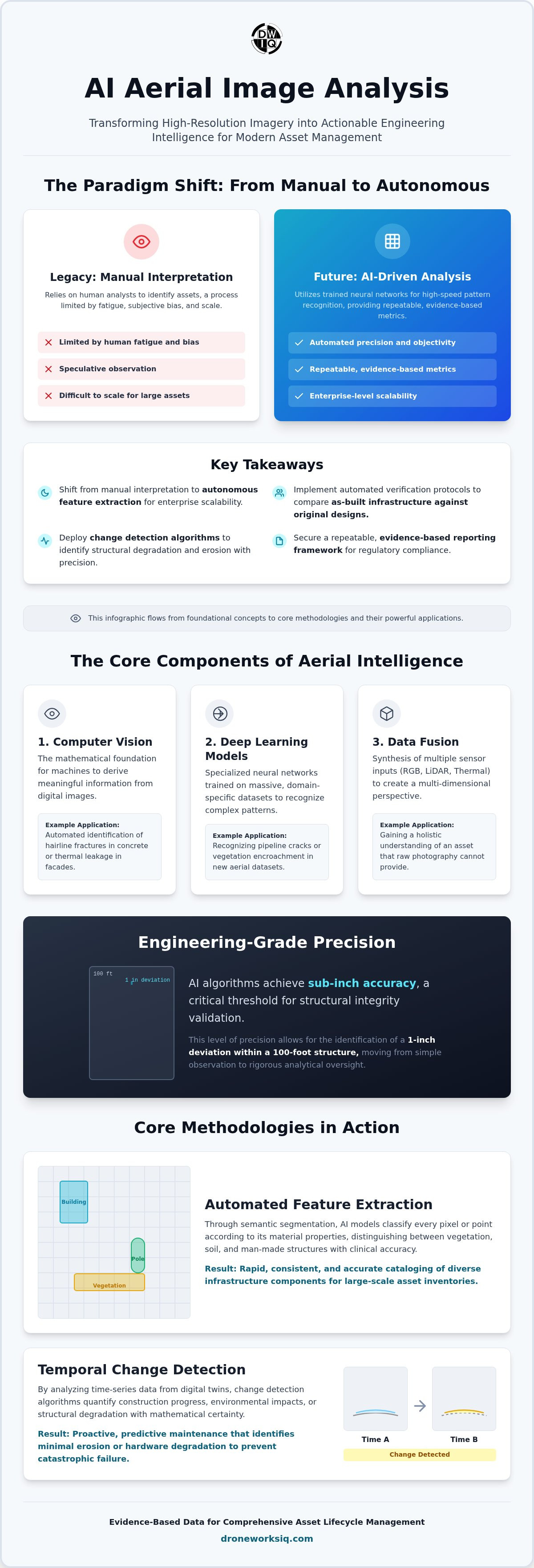
The contrast between legacy manual photogrammetry interpretation and autonomous feature extraction is stark. Manual digitization relies on human analysts to identify assets, a process inherently limited by fatigue and subjective bias. In contrast, AI-driven systems utilize trained neural networks to execute high-speed pattern recognition across massive datasets. It's a fundamental change in methodology. This transition replaces speculative observation with repeatable, evidence-based metrics, providing the high-confidence documentation required for rigorous asset lifecycle management.
The Core Components of Aerial Intelligence
Computer vision: This fundamental AI discipline provides the mathematical foundation for machines to derive meaningful information from digital images. In an engineering context, it enables the automated identification of structural anomalies, such as hairline fractures in concrete or thermal leakage in industrial facades.
Deep Learning Models: These specialized neural networks undergo training on massive, domain-specific datasets. By exposing models to thousands of verified examples of pipeline cracks or vegetation encroachment, the system develops the ability to recognize these patterns in real-time within new aerial datasets.
Data Fusion: True engineering intelligence arises from the synthesis of multiple sensor inputs. By integrating high-resolution RGB imagery with LiDAR point clouds and thermal data, analysts gain a multi-dimensional perspective that raw photography cannot provide.
Core Methodologies: From Automated Feature Extraction to Change Detection
The technical efficacy of AI aerial image analysis rests upon its ability to execute multidimensional data processing across spatial, temporal, and spectral domains. High-resolution sensors capture raw data that algorithms then parse to achieve sub-inch accuracy. This level of precision is critical for identifying a 1-inch deviation within a 100-foot structure, a threshold necessary for structural integrity validation. By processing data through these advanced lenses, organizations move from simple observation to rigorous analytical oversight. It's a shift toward total data transparency.
Automated Feature Extraction and Classification
Feature extraction is the automated identification of physical assets within a digital point cloud. Through semantic segmentation, AI models classify every pixel or point according to its material properties, distinguishing between vegetation, soil, and man-made structures with clinical accuracy. This automated classification allows for the rapid cataloging of diverse infrastructure components, such as utility poles or complex building facades, without the latency associated with manual review. It's an essential component for large-scale asset inventories where consistency is paramount.
Temporal Change Detection and Predictive Analytics
Longitudinal monitoring through digital twinning enables the identification of subtle structural shifts over time. Change detection algorithms analyze time-series data to quantify construction progress or environmental impacts with mathematical certainty. This is particularly vital in high-stakes environments where identifying minimal erosion rates or hardware degradation can prevent catastrophic failure. For instance, a coastal erosion monitoring drone provides the repeatable datasets necessary to predict land loss and structural risk. Implementing these predictive analytics ensures that maintenance is proactive rather than reactive. Organizations seeking to enhance their oversight should evaluate how digital twinning services can stabilize long-term asset lifecycle management.
Deployment Strategies: Implementing AI Analytics Across Asset-Intensive Industries
Industrial deployment of AI aerial image analysis necessitates a strategic alignment of sensor capabilities with specific operational requirements. It's about precision. In asset-intensive sectors, the objective is the systematic validation of physical conditions against theoretical models. This ensures that maintenance and construction activities remain within strict engineering tolerances. By moving beyond simple visual records, enterprises establish a data-to-decision workflow that prioritizes high-risk anomalies and optimizes resource allocation across vast geographic areas.
Infrastructure and Utility Inspection Protocols
Automating oversight for pipeline and power line corridors significantly reduces the operational risk associated with manual ground-based surveys. High-resolution sensors coupled with AI identify hardware degradation or vegetation encroachment autonomously. For vertical assets, infrastructure inspection protocols enable the detection of thermal leaks or structural fractures at elevations exceeding 200 feet. This capability removes the need for scaffolding or rope access, streamlining high-stakes data collection. It's a safer, faster, and more accurate methodology for utility management.
Construction Intel and Progress Tracking
Verification of as-built conditions against as-designed BIM models provides a real-time audit of project status. AI-driven volumetric analysis offers stockpile measurements accurate within 2 inches, facilitating precise resource management and financial reporting. By utilizing a construction intel drone survey, project managers maintain a repeatable record for regulatory compliance and dispute resolution. This autonomous documentation ensures that all stakeholders operate from a single, verified source of truth.
Enterprise yield management relies on the integration of spectral data and machine learning. Utilizing agri-health aerial imaging, operators apply NDVI (Normalized Difference Vegetation Index) to assess crop vigor and optimize resource distribution. This analytical framework transforms raw imagery into strategic crop intelligence, allowing for targeted intervention rather than broad-spectrum application. Organizations requiring these advanced datasets should investigate Utility and Pipeline Inspection Services for comprehensive corridor oversight.
Scaling Engineering Confidence: The DroneWorksIQ Strategic Framework
The DroneWorksIQ Platform serves as the critical intersection where high-resolution geospatial capture meets rigorous analytical validation. While many systems treat data processing as a secondary GIS task, this framework prioritizes the systematic transformation of raw pixels into evidence-based engineering intelligence. By implementing AI aerial image analysis within a structured data-to-decision pipeline, organizations move beyond fragmented data silos. It's about establishing a unified source of truth. This centralized approach ensures that every analytical output meets the precision requirements of large-scale infrastructure projects.
Repeatable workflows are the foundation of engineering confidence in asset lifecycle management. When inspections are standardized through autonomous protocols, the resulting data is inherently more reliable for longitudinal studies. This consistency allows engineers to track structural changes with mathematical certainty, eliminating the variability introduced by manual human review. Through geospatial data consulting, enterprises can align these technical capabilities with high-level strategic objectives, ensuring that data collection directly supports long-term operational stability. It's a proactive model for risk mitigation.
The future of national infrastructure management depends on the seamless integration of autonomous intelligence. As datasets grow in complexity, the ability to extract actionable insights at scale will define the leaders in the geospatial sector. DroneWorksIQ remains committed to advancing these methodologies, providing the technical depth required to handle high-stakes data environments with methodical accuracy. The transition to intelligence-based oversight is inevitable for those who value precision.
Key Takeaway: The Engineering Intelligence Advantage
Shifting from interval-based maintenance to intelligence-based asset management optimizes resource allocation and minimizes structural risk. This methodology converts complex LiDAR scans and high-resolution imagery into compliance-ready reports, providing the evidence-based documentation necessary for modern industrial oversight. Precision is the primary metric for success.
Advancing Industrial Oversight through Autonomous Intelligence
The systematic integration of AI aerial image analysis within enterprise workflows ensures that infrastructure oversight is no longer limited by the constraints of manual human review. Organizations now possess the technical capacity to convert high-resolution geospatial captures into repeatable, evidence-based data outputs. This transition facilitates a high-performance environment where predictive maintenance and structural validation are driven by mathematical precision rather than periodic, interval-based inspections. It's a strategic evolution in asset management that prioritizes long-term structural integrity and operational transparency.
DroneWorksIQ provides end-to-end autonomous aerial data solutions specialized for asset-intensive industries including utilities and construction. By leveraging a comprehensive data-to-decision workflow, technical decision-makers achieve the high-confidence engineering documentation required for rigorous regulatory compliance and strategic planning. Secure the analytical prowess necessary to manage complex, high-stakes infrastructure with methodical accuracy and professional precision. Transform your drone data into engineering intelligence with DroneWorksIQ. The future of geospatial intelligence is built on precision.
Frequently Asked Questions
What is the primary benefit of AI in aerial image analysis?
AI aerial image analysis enables the autonomous processing of high-volume geospatial datasets that exceed human analytical capacity. By automating feature identification and anomaly detection, organizations eliminate the subjective bias and latency inherent in manual interpretation workflows. This systematic approach transforms raw imagery into actionable engineering intelligence, allowing for real-time oversight of critical infrastructure projects without the risk of human induced data omission.
How accurate is AI-driven feature extraction for engineering projects?
Modern AI models achieve sub-inch precision when trained on domain-specific infrastructure datasets. For engineering applications, this facilitates the identification of a 1-inch deviation within a 100-foot structure, providing the mathematical certainty required for structural integrity validation. These high-fidelity outputs ensure that every digital twin reflects the physical reality of the asset with clinical accuracy, meeting the rigorous standards necessary for regulatory compliance and long-term lifecycle management.
Can AI aerial analysis replace traditional land surveying methodologies?
AI-driven analytics augment traditional land surveying by providing significantly higher data density and reducing operational risk in hazardous terrain. While traditional methods remain essential for establishing primary geodetic control, autonomous aerial systems capture millions of data points across vast areas in a fraction of the time. This integration allows surveyors to focus on high-level data validation rather than manual point collection, resulting in a more efficient and comprehensive geospatial record.
What industries benefit most from AI-driven geospatial analytics?
Asset-intensive sectors such as utilities, pipeline management, and large-scale construction derive the most significant value from AI-driven analytics. These industries require the frequent monitoring of extensive corridors where manual inspection is logistically prohibitive. Additionally, the agricultural sector utilizes these models for yield optimization, while coastal authorities deploy them for erosion monitoring. Any industry requiring repeatable, evidence-based data for large-scale asset oversight benefits from this technological implementation.
How does AI handle different data types like LiDAR and Thermal imaging?
Advanced AI architectures utilize data fusion to integrate disparate sensor inputs into a single, multidimensional analytical framework. The system processes LiDAR point clouds for structural geometry while simultaneously analyzing thermal imagery for heat signatures and RGB data for visual surface defects. This multi-spectral approach allows for the identification of complex issues, such as thermal leakage in industrial facades or subsurface moisture in agricultural environments, that remain invisible to single-sensor configurations.
Originally published by DroneWorksIQ. Legacy source.