
INSIGHTS
LiDAR Point Cloud Analysis: Transforming Raw Data into Engineering Intelligence
Automated LiDAR workflows currently reduce field survey time by up to 80 percent, yet many enterprise technical teams remain paralyzed by the resulting data overload from massive, unstructured files. You likely recognize the persistent frustration of managing dense datasets that lack the repeatability and precision required for high-stakes infrastructure decisions. Without a methodical processing framework, raw laser returns are merely a collection of coordinates rather than a strategic engineering asset. Uncertainty regarding the accuracy of automated feature extraction often necessitates manual intervention, undermining the efficiency of the initial data capture.
This article demonstrates how advanced LiDAR point cloud analysis converts unstructured data into high-precision, actionable engineering intelligence for enterprise asset management. You'll discover a clear framework for processing that ensures accuracy in feature extraction and provides evidence-based data for compliance and documentation. We provide a technical overview of the transition from raw imaging to the highly accurate 3D models required for rigorous asset lifecycle management and strategic risk reduction.
Key Takeaways
Understanding LiDAR Point Cloud Analysis in Enterprise Environments
LiDAR point cloud analysis represents the systematic extraction of geometric, spatial, and semantic information from unstructured laser-scanned datasets. While foundational LiDAR technology provides the mechanism for high-speed data acquisition, it's the subsequent LiDAR point cloud analysis that translates these measurements into actionable intelligence. Raw point clouds consist of millions of discrete X,Y,Z coordinates; however, these coordinates remain functionally inert until they're classified and contextualized for engineering applications. This transformation allows technical decision-makers to move beyond visual inspection toward data-driven infrastructure management.
Enterprise asset management necessitates high-density data acquisition to ensure the reliability of structural models. For complex industrial environments, point densities exceeding 30 points per square foot are standard requirements for capturing fine-scale details like bolt patterns, weld seams, or conductor sag. This level of granularity facilitates the identification of structural deficiencies that lower-resolution methods might fail to resolve. High-density scans ensure that technical teams don't overlook minute structural anomalies that could compromise safety. By implementing these high-precision workflows, organizations reduce financial risk and operational downtime in large-scale national infrastructure projects. The resulting intelligence provides a definitive basis for capital planning and regulatory compliance.
From Raw Data to Engineering Intelligence
The transition from raw imaging to engineering intelligence relies on the creation of evidence-based documentation. Unlike traditional photography, which offers only a qualitative view, processed point clouds provide quantitative measurements that withstand technical scrutiny. Repeatability is the cornerstone of this process. It enables multi-year asset monitoring by ensuring that data captured at different intervals remains comparable. Through the platform at DroneWorksIQ, these repeatable analytics allow for the precise tracking of structural movement or erosion over time. This systematic approach ensures that every data point contributes to a comprehensive, chronological record of asset health.
The Point Cloud Processing Workflow: From Acquisition to Actionable Models
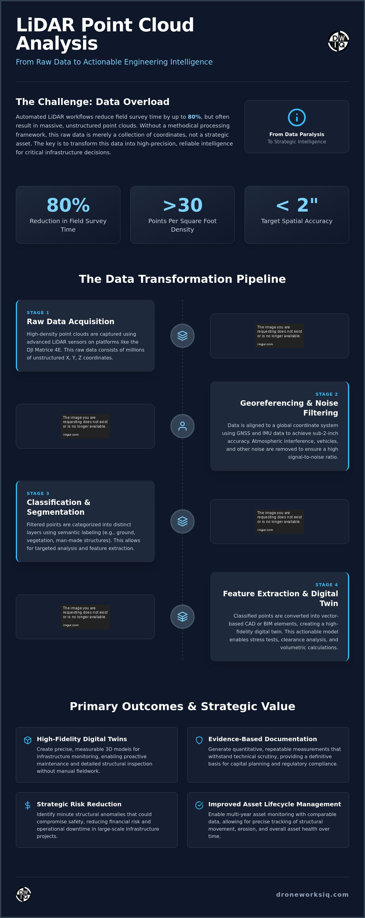
The processing lifecycle begins with data ingestion, where raw sensor outputs are transformed into spatially indexed datasets. Understanding What is LiDAR data requires recognizing it as a dense collection of laser returns that must be georeferenced to a global coordinate system. Precise alignment is achieved through the integration of GNSS and IMU data, often targeting a horizontal and vertical spatial accuracy within 2 inches. This level of precision ensures that the resulting model serves as a reliable foundation for subsequent engineering calculations and multi-temporal comparisons.
Following alignment, the dataset undergoes rigorous noise reduction and filtering. This stage involves the removal of atmospheric interference, such as dust or precipitation, alongside transient objects like vehicles or avian activity. By isolating the core infrastructure from these environmental artifacts, the LiDAR point cloud analysis maintains a high signal-to-noise ratio. This cleanliness is vital for the automated detection of structural features without the interference of non-permanent data points. Organizations seeking to optimize their infrastructure oversight often rely on the integrated processing workflows provided by DroneWorksIQ to ensure these extractions meet industrial standards.
Classification and segmentation categorize the filtered points into distinct layers, such as ground, vegetation, and man-made structures. This semantic labeling allows for targeted feature extraction, where classified points are converted into vector-based CAD or BIM elements. This transition from discrete points to geometric primitives enables engineers to perform stress tests, volumetric calculations, and clearance analyses within a digital environment. The systematic nature of this workflow ensures that every step adds a layer of intelligence, moving closer to a comprehensive digital twin.
Advanced Classification Methodologies
Precision ground filtering techniques are essential for high-precision LiDAR terrain analysis, particularly in densely vegetated corridors. These methodologies distinguish between true bare earth and low-lying scrub, enabling accurate hydraulic and geotechnical modeling. In utility and pipeline networks, advanced classification detects structural anomalies like conductor sag or encroachment, providing early warnings for preventative maintenance through automated LiDAR point cloud analysis.
Engineering Applications: Enhancing the Asset Lifecycle
Strategic utility in LiDAR point cloud analysis extends beyond initial data acquisition, serving as a foundational component for comprehensive asset lifecycle management. By converting discrete laser returns into high-fidelity geometric models, technical teams establish a quantifiable baseline for long-term structural oversight. This systematic approach facilitates the transition from reactive maintenance to a predictive, data-driven strategy. High-density datasets provide the necessary resolution to detect minute structural shifts that traditional manual inspections frequently overlook. The resulting intelligence ensures that infrastructure integrity is maintained through evidence-based decision-making and rigorous documentation.
Automated infrastructure inspection leverages these datasets to identify deformation or erosion in concrete and steel structures with clinical precision. In construction environments, comparing "as-built" point clouds against "as-designed" CAD models allows for the immediate identification of deviations from engineering specifications. This real-time progress monitoring reduces rework costs and ensures adherence to strict project timelines. Volumetric analysis further enhances operational efficiency by providing precise measurements of stockpiles or excavation sites. Modern processing algorithms achieve vertical and horizontal accuracy down to 6 inches, offering a level of detail essential for accurate material management and financial reporting.
Digital Twins for Infrastructure Intelligence
Integrating high-resolution data into an infrastructure digital twin framework creates a living 3D record of physical assets. This digital representation evolves alongside the physical structure, providing a chronological account of structural health. Leveraging specialized LiDAR digital twin services ensures that long-term maintenance schedules are informed by repeatable, high-precision data rather than subjective visual assessments. This continuous intelligence cycle supports regulatory compliance and optimizes capital expenditure throughout the asset's functional life.
Organizations requiring high-fidelity documentation and structural oversight should consult the technical experts at DroneWorksIQ for comprehensive data-to-decision support.
Strategic Implementation: Selecting an Infrastructure Intelligence Partner
Selecting a partner for LiDAR point cloud analysis requires a shift from vendor-based procurement to strategic alignment with engineering-focused entities. Corporate decision-makers must prioritize providers capable of delivering more than simple visual representations; the output must be a quantifiable engineering asset. This necessitates a rigorous evaluation of the partner's capacity for autonomous data processing and massive dataset management. Platforms that utilize AI-driven classification and quality control ensure that reporting cycles are reduced from weeks to hours, maintaining the 60 to 80 percent reduction in field survey time typical of high-performance workflows.
Adherence to national infrastructure and utility reporting standards remains a non-negotiable requirement for enterprise-level operations. A sophisticated partner ensures that all datasets comply with rigorous documentation standards to facilitate seamless regulatory auditability. Integrated data-to-decision workflows allow for the swift transition of information from raw capture to executive-level intelligence. The ability to manage and stream massive datasets using cloud-native formats is a critical technical prerequisite for large-scale industrial oversight. This technical prowess ensures that data remains accessible and actionable across the entire project lifecycle.
The DroneWorksIQ Advantage
The DroneWorksIQ platform delivers accurate, repeatable, and evidence-based information specifically designed for high-stakes industrial applications. By leveraging specialized geospatial data consulting, organizations gain access to high-level intelligence that informs strategic asset management and long-term capital planning. This AI-driven approach ensures that LiDAR point cloud analysis results in a definitive, chronological record of structural health. Our methodology provides the precision necessary for rigorous compliance and strategic risk reduction in complex, high-stakes data environments.
Operationalizing High-Precision Geospatial Intelligence
The implementation of LiDAR point cloud analysis within enterprise asset management frameworks facilitates the critical transition from passive observation to active structural oversight. Methodical processing workflows transform unstructured laser returns into high-fidelity geometric primitives, ensuring that every data point supports a specific engineering objective. By prioritizing high-density acquisition and automated feature extraction, technical decision-makers establish a quantifiable baseline for long-term infrastructure health. This systematic approach eliminates the subjectivity inherent in manual inspections while providing the evidence-based documentation that's necessary for rigorous regulatory compliance and strategic risk reduction.
Large-scale infrastructure requires a sophisticated analytical framework that integrates the entire asset lifecycle from initial planning to decommissioning. DroneWorksIQ provides specialized expertise in high-stakes utility and infrastructure assets, delivering accurate, repeatable, and evidence-based analytics through an integrated data-to-decision platform. Don't let raw data remain an underutilized resource; convert it into a high-performance strategic asset. Transform your drone data into engineering intelligence with DroneWorksIQ and establish a new standard for operational reliability. Precise intelligence is the foundation of industrial excellence.
Frequently Asked Questions
What is the difference between raw LiDAR data and a processed point cloud?
Raw LiDAR data represents the initial, unorganized stream of discrete laser returns containing coordinate and intensity information. Systematic LiDAR point cloud analysis involves georeferencing these points to a global coordinate system and applying semantic classification. This transformation isolates core infrastructure from atmospheric noise and transient artifacts. It creates a structured engineering asset suitable for high-stakes industrial decision-making and strategic risk reduction.
How accurate is LiDAR point cloud analysis for engineering measurements?
High-performance systems target spatial accuracy within 2 inches for horizontal and vertical alignment. This level of precision facilitates the detection of structural deformations or minute volumetric shifts that traditional methods ignore. Rigorous calibration of GNSS and IMU sensors ensures that the resulting models meet the strict requirements of national infrastructure reporting. The analysis provides the quantitative evidence needed for engineering-ready documentation and compliance.
Can LiDAR point cloud analysis be used for indoor asset management?
LiDAR technology is highly effective for indoor asset management and structural monitoring within complex industrial facilities. SLAM-based sensors or terrestrial scanners capture interior geometries to create high-fidelity digital twins of plant layouts or utility corridors. This data supports facade inspection and internal structural oversight where satellite-based positioning is unavailable. It ensures comprehensive documentation of assets regardless of the environment's complexity.
What file formats are typically used for analyzed LiDAR point clouds?
Standardized formats include LAS and LAZ for compressed point data exchange across geospatial platforms. Specialized engineering workflows often utilize E57 for high-resolution terrestrial scans or COPC for cloud-native streaming of massive datasets. These formats ensure interoperability between analysis software and CAD or BIM environments. This compatibility is essential for converting classified points into the vector-based elements required for structural modeling.
How does LiDAR analysis support digital twin creation?
Analysis provides the geometric and semantic foundation required for a functional digital twin. By categorizing points into man-made structures and terrain, the process creates a chronological, 3D record of physical assets. This allows for predictive maintenance and lifecycle management based on repeatable, evidence-based data. The resulting intelligence supports strategic asset management by providing a living representation of structural health over time.
Originally published by DroneWorksIQ. Legacy source.