
INSIGHTS
Maximize Crop Yields with Drone Stand Count Analysis
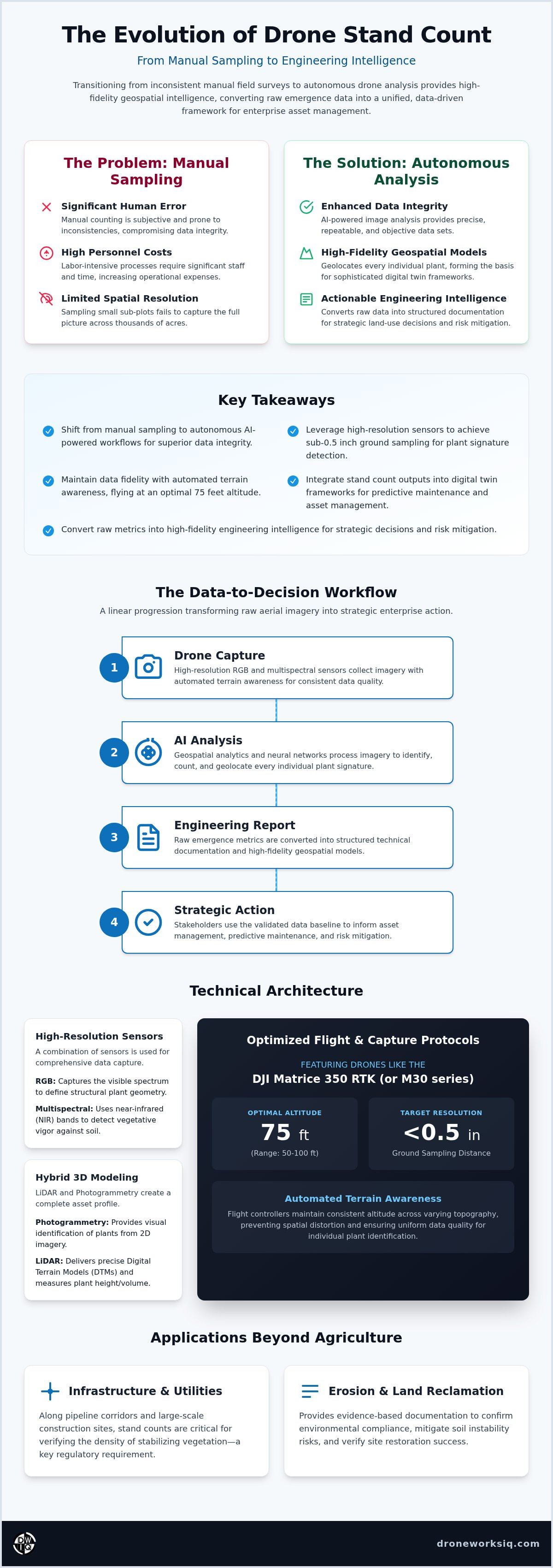
The reliance on manual emergence surveys constitutes a critical vulnerability in enterprise land management, where human error and high personnel costs compromise the integrity of large-scale data sets. You recognize that the disconnect between raw field imagery and actionable engineering intelligence creates operational bottlenecks that hinder strategic asset oversight. This article demonstrates how the deployment of an autonomous Drone Stand Count analysis protocol converts inconsistent emergence data into high-fidelity geospatial intelligence. By adopting these automated and repeatable reporting structures, organizations facilitate the seamless integration of field data into digital twin models, effectively mitigating risk across expansive land portfolios. We will examine the technical methodologies that transform basic agricultural observations into rigorous engineering outcomes, providing the precision required for sophisticated enterprise asset management. This transition from manual counting to autonomous data synthesis ensures that every acre contributes to a unified, data-driven decision framework.
Key Takeaways
Shift from subjective manual sampling to autonomous geospatial workflows powered by AI image analysis for enhanced data integrity.
Leverage high-resolution RGB and multispectral sensors to secure the sub-0.5 inch ground sampling distance required for individual plant signature detection.
Maintain consistent data fidelity through automated terrain awareness protocols, optimizing flight altitudes at 75 feet to balance coverage with resolution.
Seamlessly incorporate Drone Stand Count outputs into digital twin frameworks to facilitate predictive maintenance and sophisticated enterprise asset management.
Convert raw emergence metrics into high-fidelity engineering intelligence, providing the evidentiary basis for strategic land-use decisions and risk mitigation.
The Evolution of Drone Stand Count: From Manual Sampling to Engineering Intelligence
Traditional methods of quantifying plant emergence rely on manual sampling, a labor-intensive process where personnel physically count rows within limited sub-plots. This methodology introduces significant human error and fails to provide the comprehensive spatial resolution required for enterprise-level land management. The Evolution of Drone Stand Count represents a fundamental shift toward autonomous geospatial processing. By utilizing high-resolution aerial sensors and AI-driven image analysis, a Drone Stand Count identifies and geolocates every individual plant across thousands of acres. This transition replaces anecdotal field notes with precise, repeatable data sets that serve as the foundation for high-fidelity geospatial modeling.
The objective of modern stand analysis has expanded beyond simple population averages. We now operate in an era of engineering intelligence, where raw emergence data is transformed into structured technical documentation. For enterprise stakeholders, these counts inform the entire asset lifecycle, from initial site preparation to long-term environmental compliance. High-resolution data ensures that subsequent spatial analyses, such as drainage modeling or nutrient application maps, are built upon a validated baseline of biological emergence. It's a move from reactive observation to proactive, data-driven management.
Key Takeaway: Autonomous precision counting is no longer a secondary metric; it's the mandatory baseline for high-confidence geospatial modeling and strategic asset oversight.
Beyond Agriculture: Stand Counts in Infrastructure and Utilities
The utility of a Drone Stand Count extends into the industrial and infrastructure sectors, specifically for erosion monitoring and land reclamation. Along pipeline corridors and large-scale construction sites, verifying the density of stabilizing vegetation is a regulatory requirement. Emergence data provides the evidence-based documentation needed to confirm environmental compliance and mitigate the risk of soil instability. By applying these agricultural metrics to infrastructure assets, managers gain a sophisticated tool for verifying site restoration success and ensuring long-term structural integrity.
Technical Architecture of High-Resolution Stand Count Analysis
High-fidelity Drone Stand Count analysis requires the integration of high-resolution RGB and multispectral sensors. RGB sensors capture the visible spectrum to define structural plant geometry, while multispectral sensors utilize near-infrared (NIR) bands to detect vegetative vigor against heterogeneous soil backgrounds. Spectral separation is essential. It allows for isolating biological signatures from inorganic matter with clinical precision. Achieving this level of accuracy necessitates strict terrain awareness protocols. Autonomous flight controllers must maintain a consistent altitude, typically between 50 ft and 100 ft, to ensure a uniform ground sampling distance. This consistency prevents spatial distortion and maintains the resolution required for individual plant identification across varying topography.
The efficacy of these systems is validated by rigorous field evaluations. In Transforming Stand Count Data, research emphasizes that sensor resolution and flight parameters directly influence the reliability of digital agriculture tools. Sophisticated AI-driven geospatial analytics process this raw imagery, utilizing neural networks to distinguish between target assets and unwanted vegetation, such as weeds. This differentiation is critical for enterprise asset management. It ensures that population counts reflect actual asset density rather than biological noise. For organizations requiring this level of technical oversight, our Agri-Health Mapping services provide the necessary analytical framework.
Key Takeaway: Engineering confidence relies on the synergy between advanced hardware and sophisticated AI algorithms.
LiDAR and Photogrammetry: A Hybrid Approach to Accuracy
To enhance the structural context of a Drone Stand Count, we utilize aerial LiDAR data collection to establish a precise digital terrain model (DTM). While photogrammetry provides visual identification, LiDAR point clouds offer accurate measurements of plant height and canopy volume post-emergence. This hybrid approach allows for the creation of three-dimensional asset profiles that surpass the limitations of traditional two-dimensional imagery, providing a comprehensive view of field development.
AI-Driven Feature Extraction Protocols
Machine learning models are calibrated for pattern recognition within row-cropped environments, identifying specific geometric signatures associated with emergence. These feature extraction protocols ensure data repeatability across varying lighting conditions and atmospheric haze. By standardizing the data acquisition and processing workflow, organizations secure a reliable stream of engineering intelligence that informs long-term asset lifecycle management and operational compliance.
Strategic Implementation: Optimizing Flight Parameters for Data Fidelity
The integrity of a Drone Stand Count is established during the data acquisition phase. Achieving plant-level identification requires a ground sampling distance (GSD) of sub-0.5 in/pixel. We recommend a target GSD of less than 0.4 in/pixel to ensure the AI can resolve early-stage emergence signatures with clinical precision. Maintaining an optimal flight altitude of 75 ft above ground level (AGL) balances spatial resolution with operational efficiency. Higher altitudes compromise the pixel density needed for individual plant detection. Lower altitudes increase mission duration and data volume without providing proportional gains in analytical accuracy. Precision is non-negotiable.
Seamless orthomosaic generation relies on high-overlap imagery. We mandate a minimum of 80% front and side overlap. This redundancy ensures that the photogrammetric engine reconstructs the field with minimal geometric distortion. High overlap is critical in row-cropped environments. Repetitive patterns often cause stitching failures in lower-density data sets. By adhering to these rigorous flight protocols, organizations secure the foundational data required for high-fidelity engineering reports. It's the primary defense against data degradation.
Key Takeaway: Rigorous flight protocols are the primary safeguard against data degradation.
Environmental Constraints and Mission Planning
Mission success requires strict adherence to environmental thresholds. Solar angles must be managed to minimize shadows, as excessive shadowing interferes with AI feature extraction and pattern recognition. We schedule missions during peak solar windows to ensure uniform illumination across the canopy. Additionally, wind thresholds must be verified to prevent motion blur in high-resolution imagery. Operations should be suspended if gusts exceed 15 mph to maintain structural data integrity. To ensure your project meets these high-fidelity standards, utilize our professional Drone Mapping and Photogrammetry Services.
Transforming Stand Count Data into Actionable Asset Lifecycle Intelligence
The utility of a Drone Stand Count matures when data transitions from a static agricultural report to a dynamic input for an infrastructure digital twin. By ingesting high-resolution emergence data into a centralized geospatial model, enterprise managers move beyond simple population tallies. This integration facilitates sophisticated gap analysis and population scoring, providing the evidentiary basis for predictive maintenance and yield forecasting. These metrics identify spatial anomalies that often indicate underlying soil compaction, drainage inefficiencies, or localized erosion. The resulting intelligence allows for targeted interventions, optimizing resource allocation across expansive land portfolios.
In the context of industrial land management, a construction intel drone survey utilizes stand count protocols to verify site restoration success. Quantifying vegetation density is a critical milestone in the transition from construction to operational phases. This automated verification ensures that contractors meet contractual obligations regarding ground cover and stability. It provides a transparent, data-driven record of site status that eliminates the subjectivity of ground-based visual inspections. This rigorous approach to data synthesis ensures that every geospatial data point contributes to a comprehensive strategy for asset oversight.
Key Takeaway: The DroneWorksIQ platform converts raw counts into evidence-based intelligence for strategic decision-making.
Compliance and Documentation Standards
Maintaining environmental regulatory compliance in utility and pipeline corridors requires precise, audit-ready documentation. A Drone Stand Count provides the necessary evidence of successful revegetation, meeting stringent engineering and legal standards for land reclamation. Our platform generates structured reports that facilitate seamless regulatory filing. This systematic approach to documentation reduces legal exposure and ensures that all land management activities are supported by defensible, high-fidelity geospatial intelligence.
Long-Term Asset Lifecycle Monitoring
Effective asset management requires a longitudinal perspective. By comparing emergence data year-over-year, organizations identify chronic erosion patterns and soil health degradation that ground-level surveys might overlook. The stand count serves as the inaugural entry in a comprehensive asset history log. This historical data provides a baseline for evaluating the efficacy of land-use strategies over decades. It transforms a single point-in-time observation into a strategic component of a long-term asset lifecycle management framework.
Securing Engineering Confidence in Enterprise Land Management
The adoption of autonomous geospatial workflows represents a mandatory evolution for enterprise stakeholders seeking to mitigate operational risk and optimize land-use efficiency. By replacing subjective manual sampling with a high-fidelity Drone Stand Count, organizations secure a validated baseline for all subsequent spatial analyses. This technical transition ensures that emergence data isn't merely a seasonal metric but a foundational component of a comprehensive asset history log. Integrating these results into digital twin models facilitates predictive maintenance and provides the evidentiary basis required for environmental compliance.
The precision achieved through optimized flight parameters and AI-driven feature extraction protocols provides the clinical accuracy necessary for high-stakes decision-making. Strategic asset management relies on the ability to transform raw field imagery into structured, engineering-grade documentation. Transform your aerial data into engineering intelligence with DroneWorksIQ to leverage accurate, repeatable, and evidence-based reporting. This systematic approach to data synthesis empowers your organization to handle complex, high-stakes environments with methodical accuracy. We look forward to supporting your transition toward a more data-driven and resilient operational framework.
Frequently Asked Questions
What is the typical accuracy level of a drone stand count versus manual methods?
Autonomous drone stand counts typically achieve accuracy levels exceeding 95%, providing a significant improvement over traditional manual sampling. While human observers rely on small, extrapolated sub-plots that are prone to counting errors and bias, aerial surveys analyze 100% of the target area. This comprehensive spatial coverage eliminates the statistical variance inherent in ground-based observations, delivering a more reliable data set for enterprise asset management.
How many acres can a drone count in a single flight session?
An enterprise-grade drone can typically analyze between 100 and 500 acres in a single session, depending on the required ground sampling distance and battery capacity. When maintaining a flight altitude of 75 ft to secure high-fidelity data, coverage is optimized for analytical precision rather than raw speed. Through coordinated multi-battery deployments, thousands of acres can be processed within a single operational window to meet large-scale survey requirements.
Can drone stand counts distinguish between different plant species or weeds?
Yes, sophisticated machine learning models utilize both geometric signatures and spectral data to differentiate between target assets and unwanted vegetation. By analyzing the specific structural patterns of row-cropped plants versus the irregular growth habits of weeds, the Drone Stand Count algorithm filters out biological noise. This ensures that population scores accurately reflect emergence density, providing the technical clarity required for rigorous engineering intelligence.
What sensor resolution is required for accurate stand count analysis at 100 ft?
Achieving individual plant identification at a 100 ft altitude requires a high-resolution sensor capable of delivering a ground sampling distance of sub-0.5 inches per pixel. We utilize 45-megapixel or higher RGB sensors to maintain the structural detail necessary for resolving early-stage emergence signatures. High pixel density is critical at this height, as lower-resolution imagery lacks the clarity to distinguish small seedlings from soil clods or surface debris.
How do drone stand counts integrate with existing geospatial information systems (GIS)?
Processed data sets are exported in standardized formats, such as GeoTIFF or Shapefiles, to facilitate seamless ingestion into enterprise GIS platforms. This integration allows stand count results to be overlaid with historical yield maps, terrain models, and soil health data. By centralizing these metrics within a digital twin framework, organizations establish a holistic approach to land management where every geospatial data point informs long-term strategic planning and regulatory documentation.
Originally published by DroneWorksIQ. Legacy source.