
INSIGHTS
Accurate Bridge 3D Reconstruction for Better Inspections
With 41,600 bridges across the United States currently classified in poor condition, the reliance on manual, subjective visual assessments has reached a critical threshold of operational inefficiency. Traditional methodologies often require inspectors to operate at heights of 60 feet or more above water, frequently necessitating lane closures that disrupt regional commerce. Bridge 3D Reconstruction for Bi-Annual Inspections offers a sophisticated, data-driven alternative to these high-risk, fragmented processes. You likely recognize that standard inspection reports often lack the precision required for rigorous asset lifecycle management, as they remain susceptible to human error and variable interpretation.
This technical analysis demonstrates how advanced LiDAR point cloud analysis and 3D reconstruction transform raw aerial data into repeatable, engineering-grade evidence for NBIS regulatory compliance. We provide a comprehensive overview of the systematic workflow designed to eliminate subjectivity and reduce liability through high-fidelity documentation. By integrating these autonomous systems into your oversight strategy, you can transition from reactive maintenance to a proactive, evidence-based model of infrastructure intelligence and strategic asset management.
Key Takeaways
Transition from subjective manual assessments to an evidence-based framework that eliminates safety risks associated with traditional snooper truck or rope access methods.
Utilize the technical synergy between LiDAR for structural geometry and photogrammetry for high-fidelity detection of surface-level degradation.
Deploy Bridge 3D Reconstruction for Bi-Annual Inspections to secure repeatable, georeferenced records that satisfy stringent NBIS regulatory requirements.
Integrate digital twins into engineering workflows to shift from reactive maintenance to strategic, data-driven asset lifecycle management.
SAMPLE INSPECTION REPORT
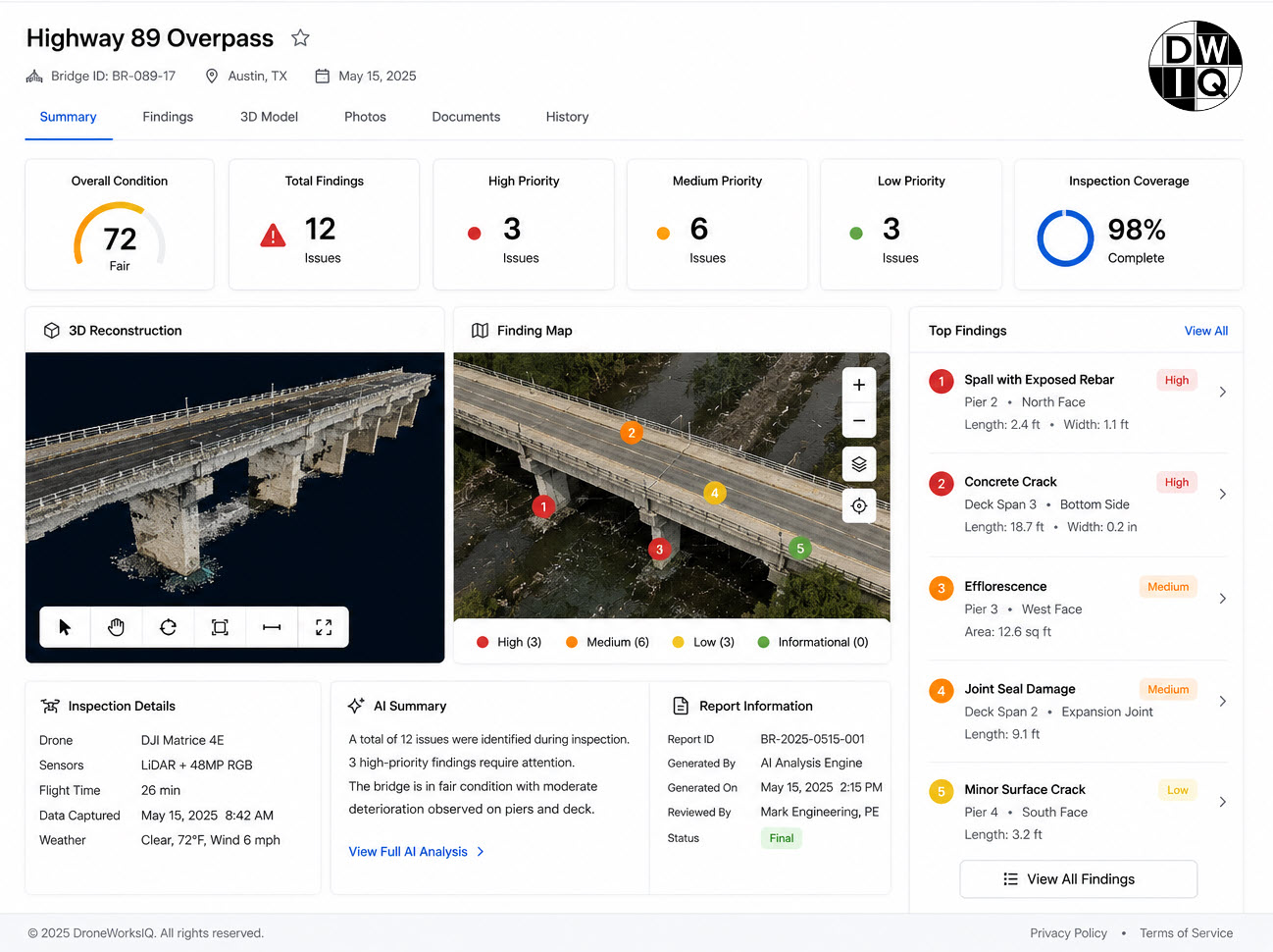
SAMPLE INSPECTION REPORT
The Evolution of Bi-Annual Bridge Inspections: From Subjective to Evidence-Based
The historical reliance on manual visual inspection methods for national infrastructure has introduced systemic vulnerabilities in data reliability. Traditional protocols often require inspectors to operate at heights exceeding 50 feet, utilizing snooper trucks or rope access systems that compromise personnel safety and necessitate extensive lane closures. These methods yield qualitative, subjective reports that vary significantly between individual inspectors. Bridge 3D Reconstruction for Bi-Annual Inspections addresses these deficiencies by establishing a quantitative, engineering-grade digital record. By deploying autonomous aerial systems, agencies can generate repeatable structural baselines that facilitate precise longitudinal health monitoring. This transition from subjective observation to evidence-based analysis ensures that structural anomalies are identified through high-density data rather than human estimation.
Regulatory Compliance and Safety Standards
Modernizing inspection workflows is essential for alignment with National Bridge Inspection Standards (NBIS), which mandate comprehensive evaluations every 24 months. Drone-based 3D reconstruction provides the granular documentation required for rigorous engineering audits. These digital twins integrate seamlessly into a broader Bridge Management System (BMS), offering a verifiable audit trail that withstands regulatory scrutiny. This systematic approach ensures that every structural component is documented with georeferenced accuracy, fulfilling federal safety mandates while minimizing the liability associated with incomplete or inconsistent manual records.
The ROI of Autonomous Aerial Intelligence
The financial implications of transitioning to UAV-driven data collection are substantial. Replacing heavy machinery like snooper trucks and scaffolding with autonomous aerial platforms drastically reduces operational overhead and equipment mobilization costs. Beyond direct expenses, the elimination of lane closures prevents regional economic friction caused by traffic disruptions. High-fidelity 3D models provide significantly higher data density than traditional photography, allowing engineers to perform virtual inspections from a secure office environment. This efficiency allows for more frequent monitoring of critical assets without a proportional increase in budgetary requirements.
Engineering-Grade Data Acquisition: LiDAR vs. Photogrammetry for Structural Fidelity
Achieving the structural fidelity required for Bridge 3D Reconstruction for Bi-Annual Inspections necessitates a strategic selection of remote sensing technologies. LiDAR serves as the primary instrument for geometric acquisition, particularly in shadowed environments where passive sensors fail to resolve detail. Active LiDAR pulses penetrate under-decking and complex truss intersections, capturing high-resolution structural data without reliance on external illumination. Conversely, photogrammetry provides indispensable textural resolution. High-fidelity imagery serves as the primary vehicle for identifying surface-level degradation, such as hairline fractures, spalling, or efflorescence, which geometric point clouds alone might overlook. This dual-sensor approach ensures that the resulting digital twin is both geometrically precise and visually exhaustive.
A hybrid data collection model fuses these distinct datasets to create a comprehensive record of the asset. This synthesis allows for the precise mapping of slim features, including suspension cables and safety railings, with a verified accuracy of 0.5 inches. Such precision is critical for detecting subtle structural deformations that indicate load-bearing stress or material fatigue. Agencies seeking to implement these advanced workflows can leverage LiDAR data collection and analysis services to secure high-fidelity structural records that satisfy engineering requirements.
Point Cloud Density and Geometric Accuracy
Geometric integrity depends on uniform point cloud distribution across critical structural joints. Achieving zero-gap coverage requires high-density acquisition to ensure that every bolt, rivet, and gusset plate is represented in the final model. For bridges with spans exceeding 100 feet, sub-centimeter accuracy is mandatory to measure structural deflection over time. This level of precision allows engineers to quantify minute movements or shifts that traditional visual methods cannot detect, providing a reliable baseline for longitudinal health monitoring.
Overcoming Environmental Constraints
Complex truss systems and under-deck environments present significant shadowing and occlusion challenges. Multi-axis drone gimbals facilitate high tilt angles, enabling sensors to capture data from perspectives inaccessible to ground-based scanners or traditional snooper trucks. In low-light conditions beneath the bridge deck, active LiDAR sensors operate independently of ambient light, ensuring consistent data quality across the entire structure. This capability eliminates the data gaps typically found in imagery-only reconstructions of shaded structural components.
The 3D Reconstruction Workflow: Ensuring Data Coverage and Engineering Integrity
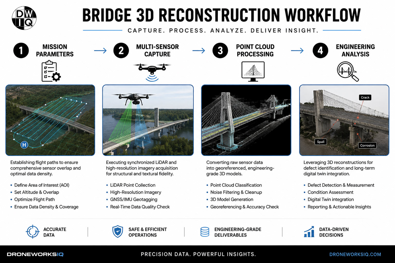
Establishing a repeatable Bridge 3D Reconstruction for Bi-Annual Inspections begins with rigorous mission planning. Flight paths must be defined with high-precision overlap, typically exceeding 80% for both frontal and side lap, to ensure comprehensive coverage of complex structural geometries. This methodical approach eliminates data shadows that often plague manual photography. By utilizing autonomous flight control, the system maintains a consistent distance from structural elements, ensuring uniform spatial resolution across the entire asset. This level of planning is the foundation for creating a reliable digital record that satisfies engineering requirements.
The conversion of raw sensor data into georeferenced point clouds requires sophisticated processing pipelines. Raw LiDAR returns and high-resolution imagery are synchronized through inertial measurement units and GNSS data to establish absolute positioning. Quality evaluation protocols must then identify and remove measurement noise or outliers that could skew structural analysis. Unlike basic photogrammetry, this engineering-grade workflow utilizes AI-driven feature extraction to isolate structural components from environmental clutter. This process results in a clean, high-fidelity model ready for technical assessment and longitudinal comparison.
Point Cloud Analysis for Structural Anomalies
High-density 3D models allow for the automated detection of spalling, corrosion, and structural cracks that might escape visual detection during traditional walk-throughs. By comparing current Bridge 3D Reconstruction for Bi-Annual Inspections to historical baselines, engineers can identify structural settling or subtle shifts in alignment. This capability is essential for monitoring the progression of known defects and ensuring that material fatigue does not exceed safety thresholds.
Data Integration and Reporting
Transforming spatial data into actionable intelligence requires integration with existing Infrastructure Intelligence Platforms. These systems consolidate 3D models and defect logs into a centralized dashboard for technical stakeholders. This integration ensures that raw data becomes a functional tool for maintenance prioritization. Agencies looking to enhance their reporting accuracy should engage LiDAR data collection and analysis services to implement these automated documentation workflows.
Strategic Asset Lifecycle Management: Integrating 3D Models into Engineering Workflows
The integration of high-fidelity models into engineering workflows marks a fundamental shift from episodic reporting to continuous asset oversight. Modern Bridge 3D Reconstruction for Bi-Annual Inspections establishes a living record that transcends the limitations of static, paper-based documentation. These digital twins allow for the longitudinal tracking of structural health, enabling technical stakeholders to visualize decay patterns and structural settling over multiple inspection cycles. This methodology facilitates evidence-based decision making, allowing for the precise prioritization of maintenance activities and more accurate capital expenditure planning. Agencies can now move beyond reactive repairs and implement a proactive strategy based on quantitative structural data.
Standardizing 3D reconstruction as the primary record for national transportation assets ensures that every bridge in a portfolio possesses a verifiable history of structural integrity. This transition reduces the uncertainty inherent in manual visual inspections. It provides a secure, engineering-grade foundation for long-term infrastructure management. By centralizing these records, agencies can ensure data continuity even as personnel change, maintaining a consistent technical understanding of the asset's condition over its entire operational life.
The Future of Infrastructure Intelligence
Infrastructure management is evolving toward predictive models. Leveraging AI-driven geospatial analytics allows agencies to identify early-stage degradation before it necessitates costly emergency repairs. By applying machine learning algorithms to georeferenced point clouds, the system can autonomously detect anomalies across thousands of assets simultaneously. This automation ensures that Bridge 3D Reconstruction for Bi-Annual Inspections delivers maximum value by highlighting critical risks that require immediate engineering attention.
Enhancing Asset Lifecycle Confidence
Positioning Infrastructure Digital Twins as the core of modern engineering management provides a strategic framework for enterprise-level intelligence. These models serve as a single source of truth for structural integrity, ensuring that bi-annual data is not just archived but actively utilized for lifecycle optimization. This framework builds institutional confidence in the safety and longevity of the bridge inventory.
Key Takeaways
3D reconstruction provides the engineering intelligence required for confident infrastructure oversight, transforming bi-annual compliance into a strategic advantage for asset lifecycle management.
Advancing Infrastructure Oversight Through Data Fidelity
The transition toward digitized structural oversight represents a fundamental shift in national infrastructure management. By replacing subjective visual observations with high-fidelity geometric records, agencies secure the structural fidelity required for long-term safety. Utilizing Bridge 3D Reconstruction for Bi-Annual Inspections ensures that every data point is georeferenced and repeatable; this provides a definitive baseline for longitudinal health monitoring. This methodology successfully fuses expert LiDAR point cloud analysis with high-resolution textural data, effectively eliminating the information gaps inherent in traditional manual workflows.
Implementing these advanced autonomous systems reduces personnel risk and operational downtime while delivering comprehensive asset lifecycle management. The result is a systematic, evidence-based history of structural integrity that withstands rigorous engineering audits. It's now possible to move beyond fragmented reporting and embrace a unified framework for infrastructure intelligence. Agencies that adopt these data-driven standards don't just meet regulatory requirements; they establish a superior model for public safety and strategic investment. Transform your infrastructure data into engineering intelligence with DroneWorksIQ and secure the future of your bridge portfolio with precision and confidence.
Frequently Asked Questions
How does 3D reconstruction improve the accuracy of bi-annual bridge inspections?
3D reconstruction improves accuracy by providing a quantitative, georeferenced model that eliminates the subjectivity of manual visual assessments during Bridge 3D Reconstruction for Bi-Annual Inspections. This high-density data capture ensures that structural measurements are repeatable and verifiable; this allows engineers to perform precise volumetric and geometric analysis. By documenting every structural component from multiple perspectives, the system provides a comprehensive record that far exceeds the detail of conventional 2D photography.
Is LiDAR or photogrammetry better for bridge structural analysis?
Optimal structural analysis requires a hybrid approach that leverages the distinct advantages of both sensors. LiDAR is essential for capturing high-fidelity geometric data in shadowed regions or under-decking where passive sensors fail to resolve detail. Photogrammetry provides the textural resolution necessary for identifying surface-level degradation such as hairline fractures and spalling. Fusing these datasets creates a comprehensive digital twin that supports both geometric integrity and visual evaluation.
Can drone-based 3D models replace manual bridge inspection documentation?
Drone-based models provide the engineering-grade evidence required to satisfy Bridge 3D Reconstruction for Bi-Annual Inspections documentation standards. While the final safety certification remains the responsibility of a licensed engineer, the 3D model serves as the primary technical record. It offers a verifiable audit trail and a level of structural detail that traditional manual reports can't replicate. This digital evidence reduces liability by providing a permanent, high-fidelity history of the asset's condition.
What is the standard level of accuracy for bridge 3D reconstruction?
High-performance 3D reconstruction workflows typically achieve sub-inch accuracy, with many systems delivering precision within 0.5 inches for critical structural elements. This level of resolution is necessary to monitor structural deflection and material fatigue over long spans, such as those exceeding 100 feet. Maintaining this accuracy ensures that the digital model remains a reliable tool for detecting minute changes in the bridge's physical state that wouldn't be visible to the naked eye.
How do digital twins assist in long-term bridge asset management?
Digital twins transform static inspection data into a dynamic asset management tool by providing a longitudinal record of structural health. They allow technical stakeholders to compare current data against historical baselines to identify subtle settling or accelerated corrosion patterns. This evidence-based approach facilitates more accurate maintenance prioritization and capital expenditure planning; it ensures that resources are allocated based on quantitative structural intelligence rather than estimated decay rates.
Originally published by DroneWorksIQ. Legacy source.