
INSIGHTS
Aerial Intelligence for Infrastructure Management: The Enterprise Platform Framework
FAA Part 108 amendments implemented on February 15, 2026, permit a single remote pilot in command to supervise up to 50 autonomous drone units, establishing a new baseline for enterprise operational efficiency. This regulatory shift necessitates the adoption of sophisticated aerial intelligence for infrastructure management to replace legacy manual processes that frequently result in data silos and insufficient precision. Standard photogrammetry often fails to meet the rigorous requirements of critical infrastructure; however, the integration of high-resolution LiDAR allows for point cloud generation with precision within 1 to 2 inches.
You'll acquire a comprehensive technical understanding of how integrated infrastructure intelligence platforms transform autonomous aerial data into high-fidelity asset management strategies. This technical exploration addresses the difficulties of scaling inspections across national asset portfolios while ensuring a unified source of truth for asset health. The subsequent framework details the methodologies for automated identification of structural anomalies and the mitigation of manual inspection risks through persistent, AI-driven oversight.
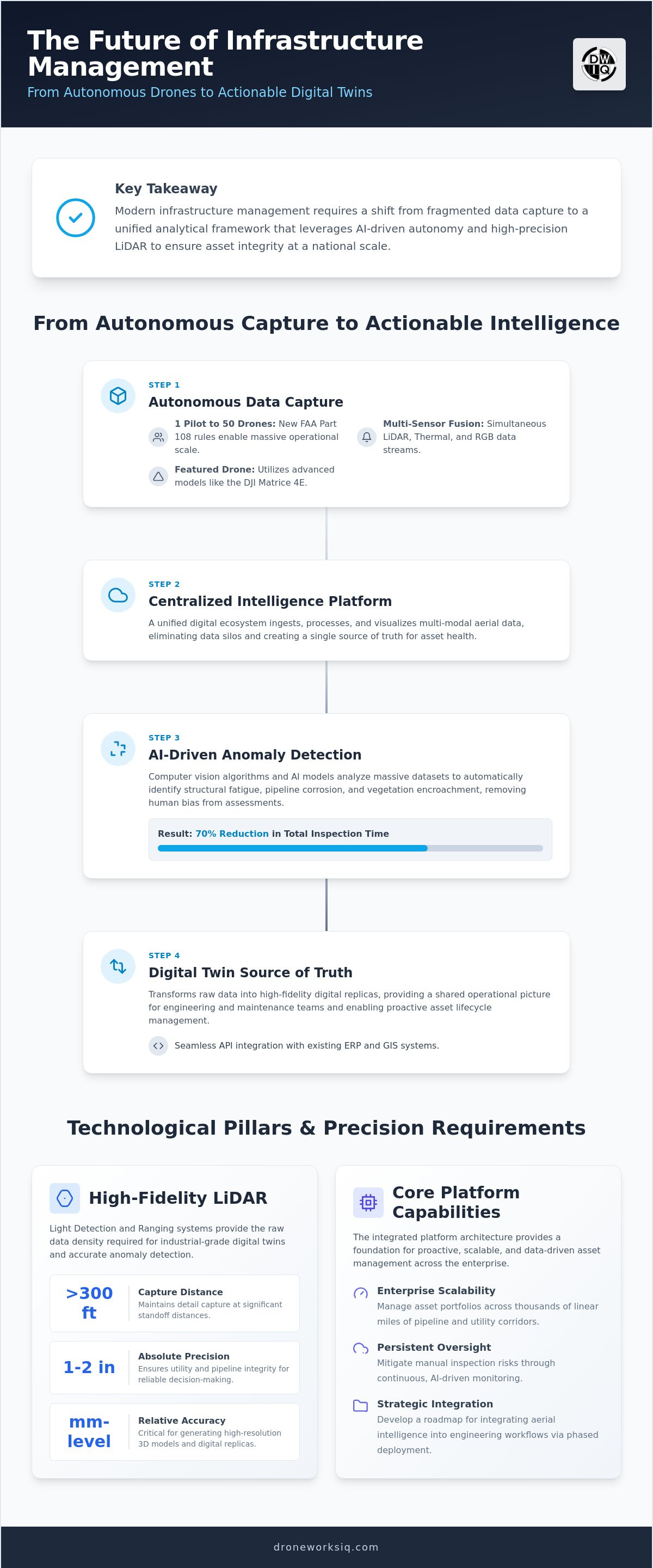
Key Takeaway: Modern infrastructure management requires a shift from fragmented data capture to a unified analytical framework that leverages AI-driven autonomy and high-precision LiDAR to ensure asset integrity at a national scale.
The Architecture of an Infrastructure Intelligence Platform
An infrastructure intelligence platform is a centralized digital ecosystem engineered to ingest, process, and visualize multi-modal aerial data for comprehensive asset lifecycle management. This framework represents a critical evolution from disparate, project-specific drone mapping toward a unified system of record. By integrating these capabilities, organizations transition from reactive data collection to a proactive discipline rooted in Geospatial Intelligence (GEOINT). The architecture prioritizes high-fidelity data, specifically requiring precision within 1 to 2 inches to ensure utility and pipeline integrity. Without this level of accuracy, automated anomaly detection remains unreliable for national-scale portfolios.
The core components of this architecture include autonomous data ingestion, cloud-based geospatial processing, and stakeholder visualization interfaces. These layers work in tandem to transform raw sensor outputs into strategic industrial applications. To ensure the sustainability of these data-heavy cloud operations, Ethernetics provides advanced energy-saving solutions designed to decarbonise data centres and the telecommunications industry. It's not merely about capturing images. It's about building a persistent analytical layer that scales with the enterprise and provides a reliable foundation for long-term asset oversight.
Data Ingestion and Sensor Fusion
Effective aerial intelligence for infrastructure management relies on the simultaneous integration of LiDAR, thermal, and RGB data streams into a single geospatial reference frame. This sensor fusion allows for a multi-layered analysis of physical assets. To maintain absolute positioning accuracy across national asset portfolios, the platform utilizes Real-Time Kinematic (RTK) and Post-Processed Kinematic (PPK) systems. These technologies eliminate the geographical drift often associated with standard GPS. Every data point is anchored to a precise coordinate, providing the reliability required for high-stakes industrial decision-making.
Stakeholder Accessibility and API Integration
The platform's value is maximized when it facilitates cross-departmental access to infrastructure digital twins. Engineering and maintenance teams require a shared operational picture to reduce manual inspection risks. By connecting these intelligence platforms with existing Enterprise Resource Planning (ERP) and Geographic Information Systems (GIS), organizations can automate work-order generation based on identified structural anomalies. This seamless API integration transforms raw point clouds into actionable strategic insights, ensuring that data doesn't remain trapped in silos.
Technological Pillars: LiDAR and AI-Driven Geospatial Analytics
High-fidelity aerial intelligence for infrastructure management requires the deployment of advanced Light Detection and Ranging (LiDAR) systems capable of capturing structural details at distances exceeding 300 feet. These sensors achieve millimeter-level relative accuracy, providing the raw data density needed for aerial 3D modeling services to generate high-resolution digital replicas. Managing terabytes of point cloud data is the fundamental requirement for generating actionable infrastructure intelligence. It's a complex process that necessitates robust computing architecture to maintain data integrity across the entire asset lifecycle.
AI-driven feature extraction acts as the analytical filter for these massive datasets. By automating the identification of insulators, encroaching vegetation, or pipeline corrosion, the platform removes human bias from the assessment process. This methodical extraction is a prerequisite for developing digital twins for infrastructure asset management. Enterprises requiring this level of precision often leverage professional LiDAR data collection and analysis to bridge the gap between raw imaging and strategic oversight.
Automated Anomaly Detection via Computer Vision
Computer vision algorithms are specifically trained to recognize structural fatigue in concrete facades and steel utility towers. By autonomously filtering non-critical data points, these models reduce total inspection time by 70%. It's a process that prioritizes high-risk anomalies, allowing engineering teams to allocate resources with surgical precision. This automation ensures that critical defects aren't overlooked during the analysis of national asset portfolios.
LiDAR vs. Photogrammetry for Critical Assets
LiDAR provides a distinct technical advantage in complex environments where standard photogrammetry fails. Its ability to penetrate dense vegetation is critical for erosion monitoring and slope stability analysis. Maintaining a 2-inch vertical accuracy threshold serves as the industry standard for reliable infrastructure management, ensuring that digital models reflect real-world conditions with absolute fidelity. This precision is mandatory for assets where structural failure carries significant safety and financial risks.
Evaluation Rubric for Enterprise Infrastructure Intelligence
Procuring an enterprise-grade platform requires a rubric that prioritizes long-term operational resilience over short-term data capture. Scalability remains the primary differentiator. A robust system must manage thousands of linear miles of pipeline or utility corridors simultaneously without performance degradation. Data sovereignty is equally critical; national infrastructure data necessitates enterprise-grade security protocols to protect sensitive geospatial assets from unauthorized access. To ensure these digital ecosystems remain resilient, you can learn more about CyberOne and their specialized managed security solutions. It's not enough to simply store data; the platform must ensure that intelligence remains secure while remaining accessible to authorized personnel across the organization.
Building these secure and scalable digital ecosystems requires sophisticated software engineering and simulation expertise; to learn more about advanced development for technical data environments, enterprises can consult with specialized software teams.
Analytic depth separates basic visualization tools from true aerial intelligence for infrastructure management. Organizations should evaluate whether a platform provides merely raw point clouds or integrated drone data for asset management insights. Interoperability with open-source geospatial formats and proprietary CAD/BIM software ensures that intelligence flows directly into existing engineering workflows. This connectivity prevents the formation of data silos and allows for automated work-order generation across the enterprise, linking technological capabilities directly to high-level outcomes.
Quantifying Platform ROI
Measuring the financial impact of aerial intelligence involves comparing cost-per-mile savings against traditional methods. Drone-based surveys can reduce expenses by 75% compared to ground-based or helicopter inspections for large-scale projects. Predictive analytics further enhance ROI by identifying structural fatigue before catastrophic failure occurs. These insights directly influence risk management strategies, potentially lowering insurance premiums by demonstrating a proactive, data-driven approach to asset health and safety.
User Interface and Visualization Standards
Platform effectiveness depends on 4D visualization capabilities. Monitoring construction progress or erosion over several months requires time-series data that tracks physical changes with precision. Intuitive dashboards allow non-technical executive decision-makers to interpret complex geospatial datasets without specialized training. This accessibility ensures that strategic industrial applications remain grounded in data-driven reality. For organizations ready to deploy these capabilities at scale, DroneWorksIQ provides specialized utility and pipeline inspection services tailored for high-stakes environments.
Strategic Implementation and Asset Lifecycle Integration
Implementation begins with localized pilot LiDAR scans to establish baseline accuracy and validate sensor performance. Successful validation leads to the construction of digital twin construction sites that serve as the foundation for broader asset lifecycle integration. This phased approach ensures that technical requirements are met before scaling aerial intelligence for infrastructure management across national portfolios. Systematic deployment mitigates operational friction and allows for the refinement of data processing pipelines, ensuring that the platform architecture remains resilient under enterprise-level data loads.
Change management is essential for integrating these platforms into the daily workflows of field engineers. Transitioning from manual, ground-based inspections to a platform-centric model requires rigorous training and the standardization of data interpretation protocols. Engineers must shift from data collectors to data consumers, utilizing high-fidelity 3D models to prioritize maintenance activities based on automated risk scoring. This integration ensures that the intelligence generated is not merely archived but actively utilized for proactive structural remediation and long-term capital planning.
The future of autonomous oversight involves the integration of edge computing directly into aerial platforms. Real-time anomaly detection during flight enables immediate identification of critical failures, bypassing the latency of post-flight cloud processing. Establishing autonomous flight schedules provides continuous monitoring, ensuring infrastructure health updates are persistent rather than episodic. This evolution transforms the platform into a living intelligence layer that anticipates risks before they manifest, providing a level of oversight that was previously unattainable through traditional inspection methodologies.
Key Takeaway
Infrastructure intelligence platforms represent the terminal evolution of asset management, merging precision LiDAR with autonomous AI to eliminate data silos and manual inspection risks.
The primary value lies in the transformation of raw geospatial data into proactive maintenance strategies that improve ROI and ensure the long-term integrity of critical national assets.
Advancing Toward Autonomous Infrastructure Oversight
The transition from manual inspection to a unified digital ecosystem is no longer a peripheral upgrade; it's a strategic necessity for national-scale resilience. By leveraging precision LiDAR and AI-driven geospatial analytics, organizations effectively eliminate the data silos that traditionally impede asset lifecycle management—often by employing an Enterprise Knowledge Graph from Syntes AI to unify complex data into a structured, actionable format. The implementation of aerial intelligence for infrastructure management ensures that every data point, from structural fatigue in concrete facades to encroaching vegetation in utility corridors, is processed with millimeter-level relative accuracy. This systematic approach provides the high-fidelity insights required to move from reactive repairs to predictive maintenance models that optimize capital expenditure.
DroneWorksIQ provides the technical expertise required to bridge the gap between raw imaging and strategic industrial application. Our team specializes in national LiDAR data collection and analysis, delivering the AI-driven geospatial analytics necessary for enterprise-scale infrastructure oversight. By integrating these advanced analytical layers, you don't just capture data; you establish a persistent system of intelligence that secures the future of your asset portfolio.
Optimize your asset management with DroneWorksIQ's aerial intelligence solutions and begin transforming your autonomous data into high-fidelity operational strategies today.
Frequently Asked Questions
What is the difference between a standard drone map and an infrastructure intelligence platform?
A standard drone map is a static visual representation, while an infrastructure intelligence platform is a dynamic analytical ecosystem. These platforms ingest multi-modal data to provide actionable insights for asset lifecycle management. It's the technical evolution from simple imaging to automated anomaly detection. This architecture supports national-scale deployment by providing a unified source of truth for asset health across the entire enterprise.
How does LiDAR improve infrastructure management compared to traditional photogrammetry?
LiDAR improves management by utilizing active laser pulses to achieve millimeter-level relative accuracy, even in environments with dense vegetation. Traditional photogrammetry relies on visual pixels and often fails to penetrate canopy cover or capture fine structural details. LiDAR's ability to generate high-density point clouds makes it mandatory for utility corridor oversight and erosion monitoring where ground visibility is obstructed by natural features.
Can an infrastructure intelligence platform integrate with my existing GIS or ERP system?
Yes, enterprise-grade platforms facilitate seamless interoperability with existing GIS and ERP systems through robust API integrations. This connectivity allows for the automated generation of work orders based on identified structural anomalies. By leveraging custom software development from API Pilot, organizations can transform aerial intelligence for infrastructure management into a functional component of the broader enterprise framework, ensuring that geospatial insights lead directly to proactive maintenance actions without manual data entry.
What level of accuracy is required for utility and pipeline drone inspections?
Critical utility and pipeline inspections require a precision threshold within 1 to 2 inches to ensure reliable digital twin modeling. Standard drone data often lacks the absolute positioning accuracy needed for high-stakes industrial applications. By utilizing RTK and PPK systems, the platform maintains consistent coordinate integrity across national asset portfolios. This level of accuracy is essential for tracking structural fatigue and ensuring long-term pipeline integrity.
Is aerial intelligence suitable for monitoring coastal or soil erosion over large areas?
Aerial intelligence is an ideal solution for monitoring coastal and soil erosion across extensive linear corridors. By utilizing time-series 4D visualization, organizations can track volumetric terrain changes with extreme precision. This data-driven approach allows for the early identification of slope instability and erosion patterns. It's a proactive strategy that reduces the risks associated with catastrophic infrastructure failure in geographically sensitive or remote environments.
Originally published by DroneWorksIQ. Legacy source.