
INSIGHTS
Agri-Health Aerial Imaging: A Strategic Framework for Enterprise Crop Intelligence
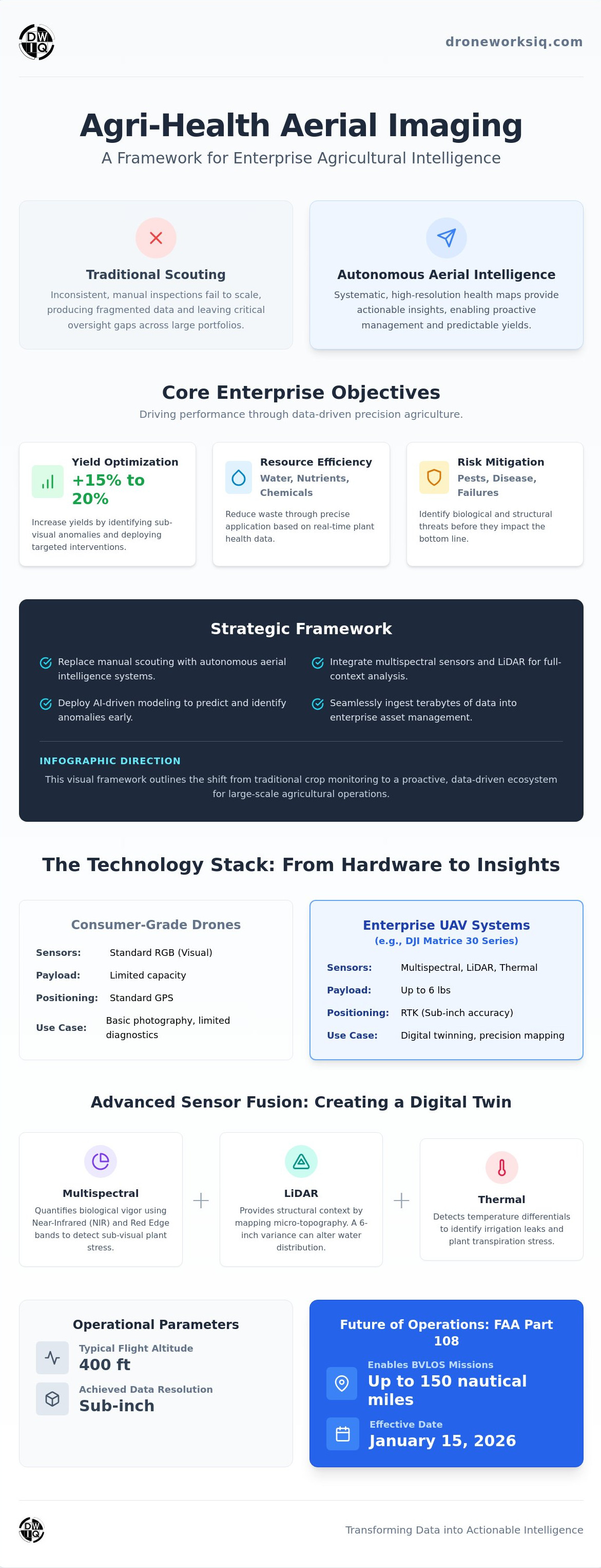
For industrial agricultural enterprises, the era of visual inspection as a primary diagnostic tool has been rendered obsolete by the integration of autonomous sensor fusion and AI-driven infrastructure intelligence. You likely recognize that traditional scouting methods produce inconsistent data and fail to scale across thousands of acres, leaving critical gaps in your asset health oversight. This article provides an authoritative framework for deploying agri-health aerial imaging to transform fragmented data silos into high-resolution, actionable health maps that drive yield predictability. With the implementation of FAA Part 108 standards on January 15, 2026, commercial operators can now conduct Beyond Visual Line of Sight missions up to 150 nautical miles without special waivers, fundamentally altering the economics of large-scale monitoring.
We will examine the strategic application of advanced multispectral sensors and the methodology for integrating predictive AI analytics into enterprise asset management systems. You'll gain technical insights into optimizing nutrient and water management through data-driven precision, supported by evidence that AI-powered systems can increase yields by 15 percent to 20 percent. This technical overview serves as a roadmap for transitioning from reactive manual inspections to a proactive, digitized crop intelligence ecosystem.
The Mechanics of Agri-Health Aerial Imaging in Large-Scale Operations
Agri-health aerial imaging is the systematic capture and analysis of multi-layered geospatial data to monitor crop vitality across vast geographic footprints. This methodology facilitates the transition from manual, ground-level scouting to autonomous aerial intelligence for national land portfolios. By leveraging AI-driven geospatial analytics, enterprises achieve a level of oversight that traditional methods cannot replicate. The process transforms agricultural acreage into a digitized asset, allowing for precise, repeatable monitoring that's essential for large-scale operations.
The primary enterprise objectives center on three critical pillars:
Yield Optimization: Maximizing output through targeted intervention.
Resource Efficiency: Reducing waste in water, nutrient, and chemical applications.
Risk Mitigation: Identifying structural or biological threats before they impact the bottom line.
These goals align with the fundamental principles of precision agriculture, where data-driven management replaces generalized application strategies. This strategic shift ensures that every acre is treated as a distinct data point within a comprehensive infrastructure intelligence framework. It's a move away from anecdotal observation toward empirical, quantitative analysis.
Beyond Visual Spectrum: The Shift to Quantitative Data
Standard RGB photography captures visible light, providing limited diagnostic utility for industrial applications. Scientifically calibrated multi-spectral imaging measures specific light wavelengths reflected by vegetation to quantify physiological stress before it's visible to the human eye, a core component of modern agri-health aerial imaging. Aerial platforms typically operate at altitudes of 400 ft to maintain sub-inch resolution. This specific flight height balances coverage area with the granular detail required for individual plant health assessments.
Enterprise vs. Consumer Grade Aerial Systems
Advanced Sensor Fusion: Integrating Multi-Spectral and LiDAR Data
Sensor fusion represents a critical advancement in agri-health aerial imaging. It moves beyond simple visual proxies to a multi-dimensional diagnostic framework. While multi-spectral sensors quantify biological vigor, LiDAR (Light Detection and Ranging) provides the necessary structural context. A terrain variance of just 6 in across a standardized plot can significantly alter localized water distribution, leading to soil saturation or drought stress in adjacent zones. By overlaying these datasets, operators identify whether vegetative decline is a result of biological pathogens or structural drainage failures.
This integration of diverse wavelengths and structural data is central to the remote sensing methodologies detailed by NASA on Precision Farming. The data allows for a more comprehensive understanding of the environmental variables influencing crop performance.
Thermal sensors complement this fusion by detecting irrigation leaks and plant transpiration stress through precise temperature differentials. High-resolution thermal mapping identifies subsurface infrastructure failures or irrigation blockages long before they manifest as surface-level saturation or visible plant wilting. This proactive detection is essential for maintaining resource efficiency in industrial environments.
The Role of LiDAR in Agricultural Infrastructure
LiDAR terrain analysis identifies micro-topography issues that dictate water distribution across thousands of acres. High-density point cloud data allows for the mapping of complex drainage patterns to prevent anaerobic soil conditions and nutrient leaching. These methodologies for large-scale land management share technical foundations with coastal erosion monitoring drone systems, where sub-inch elevation changes indicate significant structural shifts in the landscape.
Multi-Spectral Bands and Their Diagnostic Value
The diagnostic power of multi-spectral systems lies in the Near-Infrared (NIR) and Red Edge bands. These specific wavelengths are primary indicators of chlorophyll activity and cellular structure within the leaf. By fusing these spectral signatures with LiDAR-derived elevation models, enterprises create a comprehensive digital twin of the agricultural asset. This enables precise year-over-year comparison and predictive modeling for future yield cycles. For organizations seeking to implement these advanced protocols, professional agri-health mapping services provide the necessary sensor-agnostic data integration and analysis required for enterprise-level decision-making.
Diagnostic Precision: From NDVI Mapping to AI-Driven Predictive Modeling
The conversion of raw spectral reflectance into actionable intelligence relies on the generation of Normalized Difference Vegetation Index (NDVI) maps. These visualizations quantify plant health by analyzing the ratio between red and near-infrared light. Enterprise-level agri-health aerial imaging utilizes these indices as a baseline for AI-driven anomaly detection. Machine learning algorithms identify nitrogen deficiencies and pest infestations before they are detectable by human observers, enabling intervention during the earliest stages of biological stress. This systematic approach aligns with the technical standards promoted by USDA Precision Agriculture Programs, emphasizing site-specific data for resource optimization.
Temporal analysis provides the longitudinal data required for predictive modeling. Comparing high-resolution datasets over 12-month cycles allows for the identification of recurring environmental trends and structural weaknesses. This evolution from diagnostic reporting to predictive analytics empowers decision-makers to forecast yield predictability and mitigate risks through data-driven foresight. By establishing these data baselines, enterprises can move beyond reactive management toward a model of continuous asset optimization.
AI Image Analysis for Feature Extraction
Deep learning architectures enable automated feature extraction, providing precise stand counts and weed density mapping across 1,000+ acre surveys. These systems utilize sophisticated noise-filtering algorithms to remove variables like cloud shadows or terrain artifacts, maintaining data integrity. This autonomous processing is essential for large-scale operations that require rapid, accurate insights to maintain competitive advantages in high-stakes environments.
The Strategic Value of Prescription Maps
Aerial intelligence generates the foundation for variable-rate application (VRA) prescription maps compatible with autonomous machinery. These files allow for the precise delivery of nutrients and pesticides based on localized health data. Enterprises report a significant ROI through this method, often reducing chemical application by 15% by targeting only the compromised zones identified through aerial diagnostics. To integrate these advanced analytics into your operation, leverage professional enterprise drone mapping services to ensure seamless data ingestion and technical accuracy.
Strategic Implementation: Scalable Aerial Intelligence for Industrial Agriculture
Establishing a scalable framework for national land portfolios necessitates a transition from localized pilot programs to standardized enterprise protocols. Deploying enterprise drone mapping services across disparate geographic regions ensures data uniformity and repeatable accuracy. This centralized oversight allows for the benchmarking of asset performance across diverse climates and soil types, providing a macro-level view of operational health. Organizations must prioritize the standardization of sensor calibration and flight parameters to ensure that datasets remain comparable across the entire enterprise footprint.
Processing terabytes of high-resolution geospatial data requires robust, cloud-native architectures. Efficient data ingestion pipelines must account for the high-frequency capture cycles inherent in agri-health aerial imaging. Effective strategies involve automated metadata tagging and hierarchical storage management to facilitate rapid retrieval during critical decision windows. This systematic approach prevents the formation of fragmented data silos that traditionally hinder large-scale agricultural operations, ensuring that intelligence is accessible to stakeholders across the corporate hierarchy.
The integration of aerial insights into existing infrastructure digital twin platforms creates a unified source of truth for asset health. By syncing spectral and structural data with enterprise resource planning (ERP) systems, organizations achieve a comprehensive view of operational efficiency. This convergence enables a more sophisticated level of predictive maintenance for biological assets, mirroring the precision found in high-tech manufacturing sectors. It allows for the simulation of environmental stress scenarios, providing a sandbox for testing resource allocation strategies before field implementation.
The long-term strategic advantage of autonomous aerial oversight lies in the creation of a proprietary, historical dataset. This intellectual property provides a significant competitive moat, allowing for the refinement of predictive algorithms tailored to specific crop varieties and environmental conditions. It's a move toward total infrastructure intelligence, where every acre is an optimized component of a high-performance system. As autonomous systems continue to evolve, the ability to ingest and analyze multi-layered geospatial data will remain the primary differentiator in industrial agricultural performance.
Key Takeaway
Agri-health aerial imaging is an essential component of the modern enterprise agricultural tech stack, facilitating a fundamental shift from reactive scouting to proactive, data-driven asset management.
Advancing Toward Total Infrastructure Intelligence
The transition from reactive manual scouting to autonomous, multi-dimensional oversight is the defining characteristic of modern industrial agriculture. By integrating sensor fusion and AI-driven predictive modeling, enterprises transform fragmented field data into a cohesive infrastructure intelligence framework. This methodology ensures that biological asset health is no longer a variable but a quantifiable, manageable metric. The implementation of agri-health aerial imaging at scale allows for the identification of sub-visual physiological stress and structural drainage failures before they impact regional profitability.
DroneWorksIQ offers the technical precision required for high-stakes data environments. Our specialized LiDAR and multi-spectral sensor payloads deliver the sub-inch accuracy essential for digital twinning; meanwhile, our AI-driven geospatial analytics provide the predictive insights necessary for yield optimization. With national deployment capabilities, we ensure consistent data quality across your entire land portfolio. Consult with DroneWorksIQ on your enterprise agri-health aerial imaging strategy to secure your operational advantage. Your organization is now positioned to lead the evolution toward a fully digitized and predictable agricultural future.
Frequently Asked Questions
What is the difference between NDVI and NDRE in agri-health imaging?
NDVI measures spectral reflectance in the red band to assess plant vigor, while NDRE utilizes the red edge transition zone to quantify chlorophyll content in denser canopies. NDVI often saturates in high-biomass environments; consequently, NDRE provides superior diagnostic precision during late-stage growth cycles. This spectral differentiation is vital for maintaining accurate agri-health aerial imaging protocols across varied crop phenologies and growth stages.
How accurate is drone-based agri-health mapping compared to satellite imagery?
Drone-based systems provide sub-inch spatial resolution, significantly exceeding the 10 ft to 30 ft resolution typical of commercial satellite constellations. Low-altitude flight paths allow sensors to operate beneath cloud layers, ensuring data continuity regardless of atmospheric conditions. This granular detail facilitates individual plant analysis, whereas satellite data is generally limited to broad field-level trends and lacks the precision required for early-stage anomaly detection.
Can aerial imaging detect specific pests or only general crop stress?
Advanced imaging detects specific biological threats by identifying unique spectral signatures and morphological damage patterns associated with particular pathogens or insects. AI-driven feature extraction differentiates between localized pest infestations and generalized nutrient deficiencies through high-resolution spatial analysis. Early identification enables targeted chemical application, preventing the escalation of localized outbreaks into enterprise-wide yield losses before symptoms are visible to the human eye.
What are the hardware requirements for enterprise-level agri-health data collection?
Enterprise operations require industrial-grade UAV platforms capable of supporting 5 lb sensor payloads and integrated RTK modules for sub-inch spatial accuracy. These systems must facilitate the simultaneous deployment of multi-spectral, thermal, and LiDAR sensors to ensure comprehensive data fusion. High-capacity data links and autonomous flight controllers are also necessary for managing Beyond Visual Line of Sight missions across large-scale industrial assets.
How does LiDAR data enhance traditional multi-spectral crop health maps?
LiDAR data provides a high-fidelity topographical layer that identifies structural impediments to crop vitality, such as micro-topography variances and drainage inefficiencies. Integrating this structural context with agri-health aerial imaging allows operators to distinguish between biological stress and environmental factors like soil saturation. This fusion is essential for creating accurate digital twins and optimizing irrigation infrastructure across complex terrains where elevation changes impact water distribution.
Originally published by DroneWorksIQ. Legacy source.