
INSIGHTS
Autonomous Aerial Data Collection: The Enterprise Strategic Framework for 2026
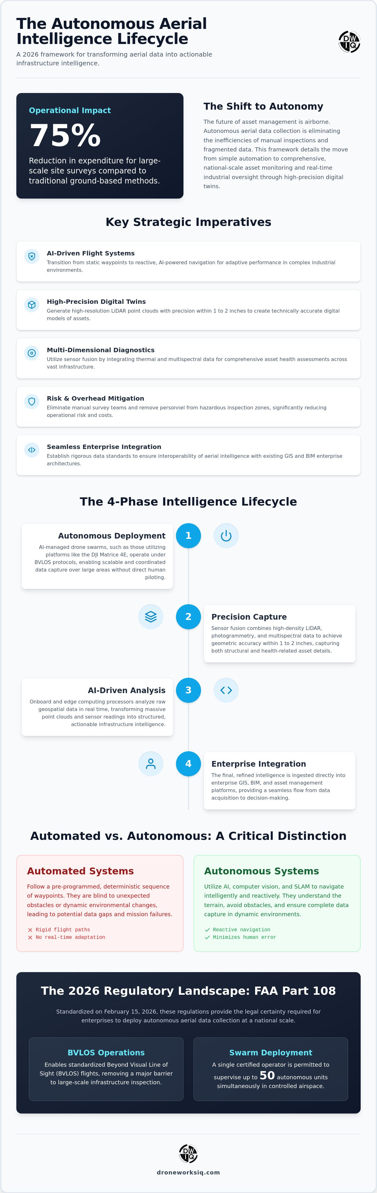
Drone-based surveys now offer a 75% reduction in expenditure compared to traditional ground-based methodologies for large-scale sites. For enterprise asset managers, the systemic friction caused by manual inspection cycles and fragmented data silos remains a primary barrier to operational scaling and asset reliability. The adoption of autonomous aerial data collection serves as the definitive mechanism for eliminating these inefficiencies while establishing a high-precision digital twin environment.
This strategic framework for 2026 details the transformation of raw geospatial inputs into clinical infrastructure intelligence with absolute technical precision. We examine the integration of high-density LiDAR sensors and 3D modeling workflows into a unified, autonomous system. By leveraging the latest FAA Part 108 swarm regulations and standardized Beyond Visual Line of Sight (BVLOS) protocols, the enterprise can move beyond simple automation toward comprehensive, national-scale asset monitoring and real-time industrial oversight.
The Evolution of Autonomous Aerial Data Collection in 2026
The landscape of aerial intelligence in 2026 is defined by a departure from rigid, pre-programmed flight paths. Traditional Unmanned aerial vehicle operations relied on static waypoints, which lacked the cognitive flexibility to manage environmental variables in real time. Modern autonomous aerial data collection utilizes onboard AI to execute reactive flight decisions, ensuring comprehensive sensor coverage even in dynamic or GPS-denied environments. Manual data collection has become functionally obsolete for national-scale infrastructure; the scale of modern utility networks and pipeline corridors exceeds the capacity of human-piloted systems to maintain consistent data fidelity.
Strategic efficiency is now driven by edge computing. Onboard processors validate data quality during the mission, identifying sensor occlusions or motion blur before the unit returns to base. This eliminates the necessity for repeat site visits and ensures that the resulting datasets are immediately ready for high-precision 3D modeling or digital twinning. The objective is no longer just flight; it's the real-time transformation of raw sensor inputs into actionable intelligence. To explore how similar AI-driven logic is revolutionizing other enterprise data workflows, find out more about intelligent document processing platforms.
Automated vs. Autonomous: A Strategic Distinction
Automated systems follow a deterministic sequence of coordinates, remaining blind to unexpected obstacles or shifting atmospheric conditions. Autonomous systems represent an intelligent evolution, utilizing computer vision and SLAM (Simultaneous Localization and Mapping) to navigate complex structures like utility towers with clinical precision. This reactive capability minimizes human error and prevents the data gaps common in manual or strictly automated workflows. It's the difference between following a map and understanding the terrain.
The 2026 Regulatory Landscape for US Enterprise
The implementation of FAA Part 108 amendments on February 15, 2026, has standardized the commercial deployment of AI-powered drone swarms. These regulations facilitate Beyond Visual Line of Sight (BVLOS) operations, allowing a single operator to supervise up to 50 autonomous units in controlled airspace. For enterprise stakeholders managing national infrastructure, this regulatory framework provides the legal certainty required to deploy autonomous aerial data collection at scale while maintaining full compliance with Remote ID and unified traffic management protocols.
Technical Architecture: LiDAR Fusion and AI-Driven Analytics
Modern technical frameworks for autonomous aerial data collection prioritize the integration of heterogeneous sensor arrays to achieve maximum data density. High-resolution LiDAR systems now routinely capture point clouds with a vertical and horizontal accuracy within 1 to 2 inches. This geometric precision provides the structural foundation for digital twin development. By incorporating multispectral and thermal sensors, enterprises gain the ability to perform comprehensive asset health assessments that go beyond visual inspection. This level of geospatial data collection ensures that every facet of an asset's physical state is documented with clinical accuracy.
The processing of raw point clouds into high-fidelity 3D models requires a systematic computational pipeline. It's the technical bridge between raw sensor feedback and a functional digital twin. Edge-based validation protocols ensure that collected data meets the rigorous standards required for infrastructure intelligence before the mission concludes. This architecture eliminates the traditional latency between data acquisition and analytical output, providing a streamlined path to decision-ready insights.
LiDAR and Photogrammetry: A Multi-Sensor Approach
Fusing LiDAR data with high-resolution photogrammetry creates a comprehensive dataset where geometric integrity meets visual context. While LiDAR provides the sub-inch precision necessary for facade and pipeline inspections, photogrammetry provides the high-fidelity texture required for visual defect identification. This dual-stream approach is essential for identifying micro-fractures in concrete or hairline corrosion on utility hardware. It's a methodology that ensures technical clarity across every square inch of the target asset.
Transforming Raw Data into Infrastructure Intelligence
The transition from raw point clouds to structured intelligence relies on AI-driven geospatial analytics. These algorithms automate feature extraction, identifying structural anomalies or erosion patterns without the latency associated with manual review. Autonomous systems ensure data consistency across longitudinal studies, allowing for precise change-detection analysis over multiple site visits. Organizations seeking to optimize these workflows can explore specialized LiDAR data collection and analysis services to accelerate their digital transformation.
Quantifying the ROI of Autonomous Aerial Intelligence
Enterprise valuation of autonomous aerial data collection is calculated through the direct reduction of operational overhead and the mitigation of high-consequence liabilities. Traditional inspection protocols for national-scale assets require large manual survey teams. This often results in 50% to 75% higher costs than autonomous alternatives. Utilizing enterprise drone mapping services eliminates the systemic costs associated with repeat site visits and manual data entry errors. High-stakes environments such as high-rise facades or pressurized pipeline corridors present significant safety risks that autonomous systems effectively neutralize.
The strategic application of uav land surveying accelerates project timelines by providing real-time geospatial updates that ground-based crews cannot match. Effective data management for autonomous aerial systems ensures that these rapid captures translate into verified, auditable records for regulatory compliance. This precision is non-negotiable for enterprise-level risk management.
Efficiency Gains in Large-Scale Infrastructure
Ground-based surveying for 50-acre sites typically requires multiple days of field work. In contrast, autonomous aerial workflows complete the same capture in under 90 minutes. This speed of data delivery is critical for infrastructure updates where delayed intelligence leads to cascading operational failures. Total man-hour requirements drop by up to 80% for large-scale asset monitoring. The efficiency is measurable and immediate.
Data-Driven Decision Making and Predictive Maintenance
Consistency in data acquisition allows for the development of high-fidelity predictive models. By analyzing structural wear or erosion patterns over time, AI-driven analytics identify potential points of failure before they manifest as critical outages. The adoption of autonomous aerial data collection provides the high-fidelity data streams required for these advanced analytical tools. This proactive oversight directly influences insurance premiums and ensures rigorous adherence to federal compliance reporting. Organizations seeking to optimize asset longevity should integrate DroneWorksIQ’s drone mapping and photogrammetry services into their strategic framework.
Implementation: Integrating Autonomous Data into Enterprise Workflows
Successful deployment of autonomous aerial data collection requires a systematic integration into existing enterprise architectures. The primary objective is the seamless alignment of raw sensor outputs with established Geographic Information Systems (GIS) and Building Information Modeling (BIM) platforms. Establishing rigorous data standards ensures that high-density point clouds and multispectral assets remain interoperable across various departmental silos. For enterprises with global footprints or those operating in the Asia-Pacific region, supporting these complex technical integrations often requires specialized expertise, such as the managed remote talent provided by Havelock Tech for technology and operations teams. Without this technical standardization, the efficiency gains of autonomous flight are often negated by the friction of manual data conversion and processing.
Scalability across national infrastructure assets depends on a robust, cloud-based infrastructure intelligence platform. These systems must facilitate the ingestion of massive datasets while providing the distributed computational power necessary for real-time AI-driven feature extraction. Future-proofing a geospatial strategy involves adopting autonomous-ready data formats that anticipate advancements in sensor resolution and machine learning. Selecting a strategic partner for national-scale LiDAR data collection and analysis is a critical decision; it ensures that technical execution remains consistent with the strategic requirements of the enterprise.
Key Takeaway: The Shift to Autonomous Oversight
True autonomy serves as the fundamental prerequisite for real-time infrastructure intelligence. As manual methodologies become obsolete, the enterprise must prioritize professional geospatial consulting to navigate the complexities of high-stakes data interpretation. This transition isn't merely a hardware upgrade; it's a shift toward a continuous, autonomous oversight model that guarantees asset reliability through clinical precision.
Architecting the Future of Infrastructure Intelligence
The transition toward autonomous aerial data collection is no longer a prospective upgrade; it's the operational baseline for enterprise asset resilience. By moving beyond simple automated waypoints to reactive, AI-managed flight systems, organizations eliminate the systemic risks and high costs inherent in manual inspection cycles. The integration of precision LiDAR and multispectral sensors provides the high-fidelity data required for predictive maintenance and digital twinning at a national scale. This strategic shift ensures that every data point captured contributes directly to long-term asset longevity and rigorous regulatory compliance.
Success in this high-stakes environment demands a partner with a clinical focus on data precision and technical authority. DroneWorksIQ offers specialized LiDAR and AI-driven geospatial analytics expertise, providing comprehensive national US coverage for the infrastructure and utility sectors. Our enterprise-focused approach ensures that your geospatial strategy remains robust, scalable, and future-ready. Consult with DroneWorksIQ for National Autonomous Aerial Intelligence Solutions to optimize your industrial oversight and achieve unmatched technical clarity. Secure your operational future with a high-performance data strategy.
Frequently Asked Questions
How does autonomous aerial data collection differ from traditional drone surveying?
Autonomous aerial data collection replaces deterministic waypoint navigation with reactive, AI-managed flight protocols. While traditional surveying relies on human-defined paths or manual oversight, autonomous systems utilize onboard computer vision to adapt to environmental variables dynamically. This capability ensures complete sensor coverage in complex industrial zones where static flight plans often fail to account for moving obstacles or shifting atmospheric conditions.
What is the typical accuracy of autonomous LiDAR data collection for infrastructure?
Modern autonomous LiDAR systems deliver high-resolution point clouds with a clinical accuracy range of 1 to 2 inches. This level of precision is achieved through the integration of Real-Time Kinematic positioning and advanced inertial measurement units. These systems facilitate the creation of sub-inch accurate digital twins, providing the geometric fidelity required for engineering-grade facade inspections and structural deformation monitoring across expansive utility networks.
Can autonomous drones operate in GPS-denied environments for indoor or facade inspections?
Autonomous systems maintain operational stability in GPS-denied environments by utilizing Simultaneous Localization and Mapping and visual odometry. These technologies allow the unit to navigate confined indoor spaces or high-rise facades by referencing physical landmarks rather than satellite signals. This technical autonomy is essential for inspecting subterranean pipelines or complex industrial interiors where traditional signal reception is non-existent or unreliable.
How do AI-driven geospatial analytics improve data processing times?
AI-driven geospatial analytics eliminate the latency associated with manual data interpretation by automating the feature extraction process. Algorithms rapidly identify structural anomalies, erosion patterns, or vegetation encroachment within massive datasets that would traditionally require hundreds of man-hours to review. This computational efficiency allows enterprises to transition from data collection to actionable infrastructure intelligence in a fraction of the time required by legacy workflows.
What are the main safety benefits of switching to autonomous aerial inspections?
The primary safety benefit involves the total removal of personnel from high-consequence environments. Autonomous aerial data collection executes inspections of high-voltage utility corridors, vertical facades, and remote pipeline networks without risking human life. By replacing manual climbers and ground crews with autonomous units, enterprises mitigate liability and ensure rigorous adherence to safety protocols while maintaining a continuous oversight cycle in hazardous industrial zones.
Originally published by DroneWorksIQ. Legacy source.