
INSIGHTS
Closing the Capacity Gap for Mid-Sized Drone Businesses
The proliferation of consumer-grade hardware has created a deceptive illusion of capability within the professional geospatial sector, highlighting the widening small to mid-sized drone based businesses gap. Most organizations recognize that while capturing basic aerial imagery is accessible, the transition to the sub-inch precision required for critical infrastructure documentation remains technically elusive. The industry standard for engineering-grade data demands a level of sensor calibration and systematic rigor that simple visual captures cannot provide.
This analysis identifies the technical and operational deficiencies preventing mid-market firms from delivering sophisticated enterprise-grade insights. You'll learn the methodologies required to bridge the divide between raw imagery and actionable engineering intelligence. This transition is essential for achieving the precision necessary for national-scale utility and pipeline inspections where accuracy within 1 inch or less is the non-negotiable baseline for asset lifecycle management.
Key Takeaways
Identify the sensor limitations of consumer-grade hardware that prevent the achievement of sub-inch precision required for infrastructure documentation.
Understand the small to mid-sized drone based businesses gap as a failure to convert raw aerial captures into standardized, engineering-grade geospatial intelligence.
Differentiate between high-density LiDAR point clouds and standard photogrammetry for complex asset analysis within utility and pipeline corridors.
Assess the integration of AI-driven analytics and proprietary platforms as the final requirement for delivering actionable asset lifecycle management reports.
The Capability Gap: Beyond Basic Aerial Photography
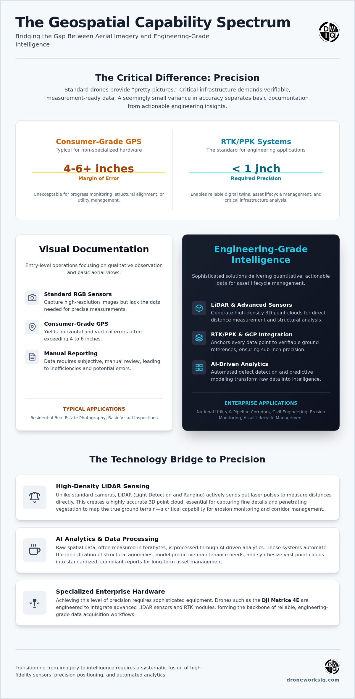
The industrial drone sector is currently bifurcated by a significant technical chasm. While many operators possess the capability to capture high-resolution imagery, the small to mid-sized drone based businesses gap becomes evident when project requirements shift from qualitative observation to quantitative engineering intelligence. Standard visual inspections rely on RGB sensors and consumer-grade GPS, which typically yield horizontal and vertical errors exceeding 4 inches to 6 inches. Such variance is unacceptable for rigorous infrastructure documentation or utility corridor management. Transitioning from "pretty pictures" to infrastructure intelligence requires a systematic overhaul of the data acquisition and processing pipeline.
The Threshold of Precision
Achieving sub-inch precision requires a fundamental shift in data acquisition methodology. A 5-inch margin of error renders digital twin progress monitoring useless for civil engineering applications where structural alignment is critical. Bridging this accuracy gap necessitates the integration of Real-Time Kinematic (RTK) or Post-Processed Kinematic (PPK) systems alongside strategically placed Ground Control Points (GCPs). These technologies ensure that every pixel or point cloud coordinate is anchored to a verifiable terrestrial reference, transforming a simple photograph into a measurement-ready data asset for complex site analysis.
Market Saturation vs. Enterprise Demand
The market is currently oversaturated with Part 107 pilots providing low-complexity services like residential real estate photography. However, there's a critical scarcity of firms capable of executing complex LiDAR data collection and analysis for national infrastructure. Enterprise clients require more than just flight operations; they demand the transformation of raw spatial data into actionable intelligence. This scarcity defines the small to mid-sized drone based businesses gap, as smaller firms lack the specialized expertise and hardware to manage national utility corridors or large-scale pipeline inspections that require repeatable, evidence-based results.
The Technical Delta: LiDAR, AI, and Engineering-Grade Precision
Scaling operations beyond basic aerial photography requires a fundamental investment in high-fidelity sensing technologies. The small to mid-sized drone based businesses gap is most pronounced during the transition from passive photogrammetric reconstructions to active LiDAR sensing. While photogrammetry provides high-resolution visual textures, it often lacks the point density and structural penetration capabilities required for rigorous engineering environments. LiDAR sensors generate direct distance measurements, creating a high-density 3D point cloud that remains accurate across varying lighting conditions and textural surfaces.
High-Resolution LiDAR Data Collection
Capturing minute infrastructure components requires sophisticated sensors capable of maintaining sub-inch precision from operational altitudes of 200 feet. Unlike standard optical sensors, LiDAR pulses can penetrate dense canopy cover to reach the underlying terrain. This capability is mission-critical for erosion monitoring services, where identifying precise ground topography beneath vegetation is necessary for accurate volume calculations and geotechnical risk assessment. The resulting data provides a level of detail that standard RGB captures cannot replicate.
AI-Driven Geospatial Insights
The transformation of raw spatial data into actionable intelligence necessitates the application of AI-driven geospatial analytics. Manual inspection of extensive image sets for building facade drone survey systems is inefficient and introduces subjective error. Automated defect detection algorithms identify structural anomalies with repeatable precision, while predictive modeling facilitates proactive maintenance for agri-health and utility corridors. These systems ensure that data remains a functional asset rather than a static record.
Managing the resulting data volume is a significant operational hurdle for firms attempting to scale. Large-scale infrastructure projects frequently generate data volumes that move from gigabytes to multiple terabytes. Robust processing pipelines must ingest these raw point clouds and synthesize them into standardized reports that meet engineering compliance requirements. This systematic approach ensures that geospatial data serves as a reliable foundation for long-term asset lifecycle management and strategic industrial oversight.
Operational Hurdles for Mid-Sized Drone Firms
Operational efficacy in the geospatial sector is defined by the ability to execute repeatable, standardized workflows across disparate geographic regions. The small to mid-sized drone based businesses gap is frequently characterized by a failure to maintain uniform data quality when scaling beyond localized projects. Enterprise-level infrastructure management requires more than just raw data acquisition; it demands a rigorous evidence-based framework that satisfies the stringent regulatory requirements of the oil, gas, and transportation sectors.
Evidence-Based Documentation Standards
Legal and compliance frameworks within heavy industry necessitate a verifiable chain of custody for all aerial data. Every measurement must be repeatable within a 1-inch tolerance to ensure the integrity of the digital twin and its subsequent analysis. Without these standards, collected data remains a liability rather than a strategic asset. Organizations must implement systematic protocols that anchor every data point to a verifiable terrestrial reference, ensuring that inspections are defensible in high-stakes engineering environments.
National Scale Logistics
Deploying specialized hardware for utility and pipeline inspection services across state lines presents significant logistical complexity. Maintaining uniform data quality in diverse geographic and atmospheric conditions requires standardized operational procedures and centralized data oversight. Small-scale firms often struggle with the mobilization of high-end LiDAR sensors and the subsequent integration of that data into a cohesive infrastructure intelligence platform.
Raw data files delivered without engineering context create isolated data silos that provide zero return on investment. The "last mile" of data delivery involves the synthesis of gigabytes of raw sensor output into actionable management reports. This integration ensures that geospatial insights are accessible to decision-makers, bridging the gap between autonomous aerial collection and long-term asset lifecycle management. Without this contextual layer, the transition from raw imagery to engineering intelligence remains incomplete.
Bridging the Gap with the DroneWorksIQ Platform
DroneWorksIQ provides the necessary infrastructure to resolve the small to mid-sized drone based businesses gap through an integrated, data-centric architecture. The platform centralizes the transformation of raw point clouds and high-resolution imagery into standardized, engineering-grade outputs. This systematic approach ensures that autonomous aerial data collection translates directly into actionable infrastructure management reports, eliminating the ambiguity inherent in manual data interpretation. By streamlining the full data-to-decision workflow, the platform enables enterprises to maintain rigorous oversight over complex asset portfolios.
Engineering-Focused Workflow Integration
The platform enables the seamless integration of 3D drone mapping services into existing enterprise asset management software. By utilizing high-precision digital twins, organizations monitor construction site progress with absolute confidence in the underlying spatial data. These models provide a repeatable baseline for structural analysis, ensuring that every measurement, whether identifying a 1-inch deviation or a 10-foot elevation change, is defensible and accurate. This integration eliminates data silos and facilitates a unified view of the asset lifecycle.
Next Steps for Enterprise Asset Managers
Evaluating a geospatial partner requires a focus on data repeatability and engineering rigor rather than simple flight capabilities. Strategic consulting ensures that complex datasets are transformed into confident executive decisions. For instance, LiDAR terrain analysis in national utility corridors allows for the identification of subtle erosion patterns, significantly reducing geotechnical risk. Organizations must prioritize partners that offer comprehensive LiDAR data collection and analysis to ensure long-term project viability.
Advancing Toward Enterprise-Grade Geospatial Intelligence
The transition from qualitative aerial documentation to quantitative infrastructure intelligence represents a critical evolution for enterprise asset management. Organizations must move beyond basic imagery to adopt specialized LiDAR and AI-driven geospatial analytics capable of delivering sub-inch precision. This shift is necessary to resolve the small to mid-sized drone based businesses gap, ensuring that data functions as a foundational asset for engineering decisions rather than a collection of unverified visual records.
By utilizing an integrated platform, enterprises achieve accurate, repeatable, and evidence-based data throughout the full asset lifecycle. This systematic approach transforms raw sensor outputs into defensible intelligence, providing the technical clarity required for high-stakes industrial applications. DroneWorksIQ provides the technical prowess and methodical accuracy necessary to manage complex data environments with absolute confidence. We look forward to facilitating your transition to high-performance geospatial oversight.
Frequently Asked Questions
What is the primary difference between a small drone business and an aerial intelligence firm?
The primary differentiator lies in the transition from qualitative visual acquisition to quantitative engineering intelligence. While small firms often prioritize basic photogrammetry and RGB imagery, an aerial intelligence firm utilizes calibrated LiDAR and RTK systems to deliver measurement-ready data. This technical distinction defines the small to mid-sized drone based businesses gap, where intelligence firms provide the systematic rigor required for enterprise-scale asset lifecycle management.
How much precision is required for an infrastructure digital twin?
Engineering-grade infrastructure digital twins require sub-inch precision to be technically viable for structural analysis and progress monitoring. Vertical and horizontal errors must be minimized to within 1 inch or less through the integration of Ground Control Points and high-fidelity LiDAR sensors. Achieving this threshold ensures the digital twin serves as a reliable geometric reference for civil engineering and asset-intensive documentation.
Can LiDAR data collection be performed over national utility corridors?
LiDAR data collection is successfully executed over national utility corridors through the deployment of long-range autonomous systems and high-density sensors. This methodology allows for the penetration of dense vegetation to map underlying terrain and vegetation encroachment with absolute accuracy. Large-scale operations require a centralized processing pipeline to manage the transition from raw point clouds to actionable infrastructure reports across expansive geographic regions.
What role does AI play in building facade drone survey systems?
AI-driven geospatial analytics automate the identification and classification of structural anomalies within building facade drone survey systems. Algorithms process high-resolution imagery to detect cracks, corrosion, or thermal variances with repeatable accuracy. This automation replaces subjective manual inspections, facilitating a standardized assessment of asset health. It accelerates the delivery of maintenance intelligence for large-scale facilities while maintaining a rigorous evidence-based record.
Why is repeatability critical for construction site drone mapping?
Repeatability ensures that temporal changes on a construction site are measured against a consistent geospatial baseline. Without standardized workflows and sensor calibration, variances in data acquisition can be misinterpreted as structural shifts or progress errors. Maintaining a repeatable 1-inch tolerance allows project managers to monitor volume changes and structural alignment with absolute confidence. This precision is essential for long-term progress monitoring.
How does DroneWorksIQ ensure compliance in asset-intensive sectors?
DroneWorksIQ ensures compliance by providing evidence-based data that adheres to the stringent regulatory standards of the oil, gas, and transportation sectors. The integrated platform maintains a verifiable chain of custody for all geospatial assets, ensuring measurements are defensible and transparent. This systematic approach transforms raw aerial captures into engineering-grade documentation that satisfies internal safety protocols and external regulatory requirements for critical infrastructure.
Originally published by DroneWorksIQ. Legacy source.