
INSIGHTS
Closing the Prosumer Commercial Drone Gap for Enterprise
The assumption that high-resolution visual capture equates to engineering intelligence is a significant fallacy in industrial asset management. The prosumer commercial drone gap represents a fundamental disconnect between consumer-grade hardware capabilities and the rigorous data requirements of large-scale infrastructure projects. While prosumer systems may operate at altitudes of 200 feet, they frequently fail to deliver the repeatable, sub-inch accuracy essential for compliant geospatial modeling.
You've likely experienced the operational friction caused by data inconsistency and the inability to integrate raw drone imagery into complex engineering workflows. This analysis clarifies why the technical gap between prosumer hardware and enterprise-grade engineering intelligence is critical for industrial asset management. We'll examine the methodologies required to transform raw imagery into evidence-based intelligence, ensuring your data meets the precision standards demanded by modern asset lifecycle management and risk mitigation strategies.
Key Takeaways
Identify the systemic vulnerabilities created by the prosumer commercial drone gap when low-cost hardware is substituted for engineering-grade geospatial systems.
Understand the technical superiority of LiDAR for capturing ground elevation with 1 to 2 inches of accuracy in high-vegetation environments.
Evaluate the legal and operational risks associated with using inconsistent visual data for critical infrastructure inspections.
Discover how the DroneWorksIQ Platform transforms raw aerial imagery into repeatable, evidence-based intelligence for asset lifecycle management.
Defining the Prosumer Commercial Drone Gap in 2026
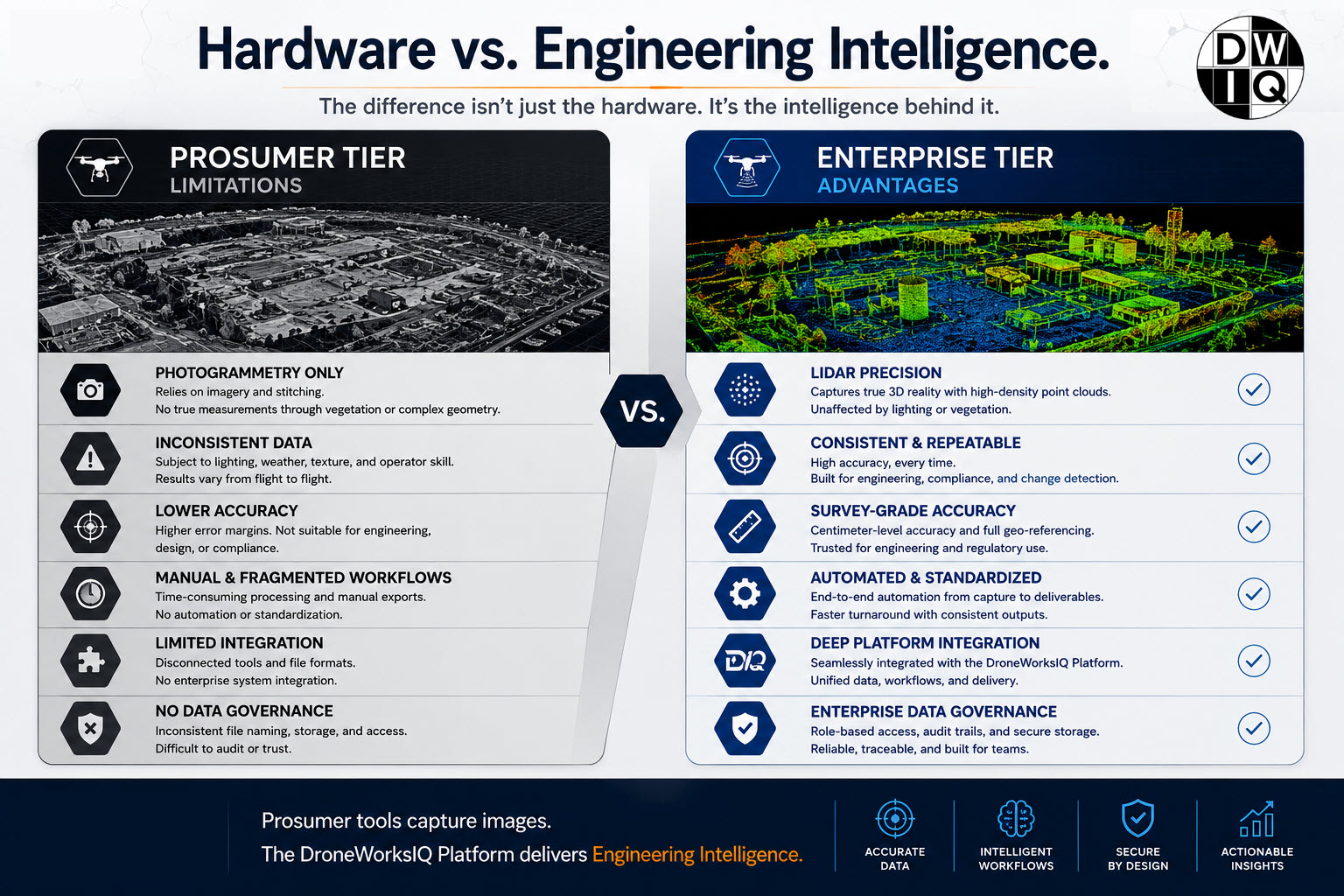
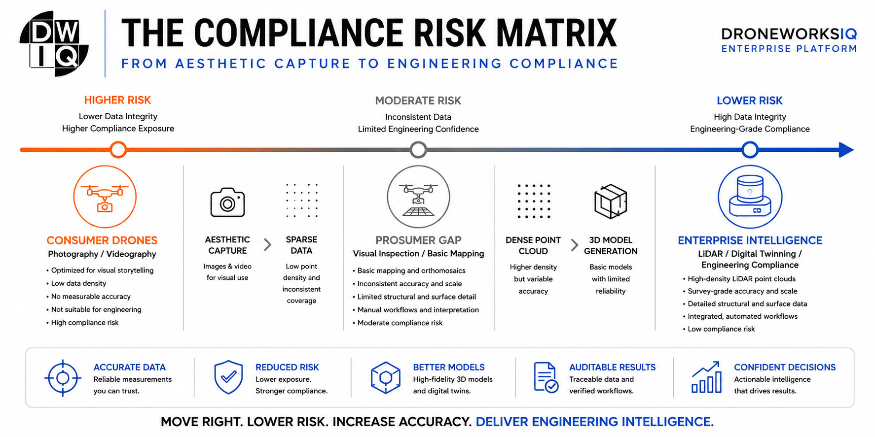
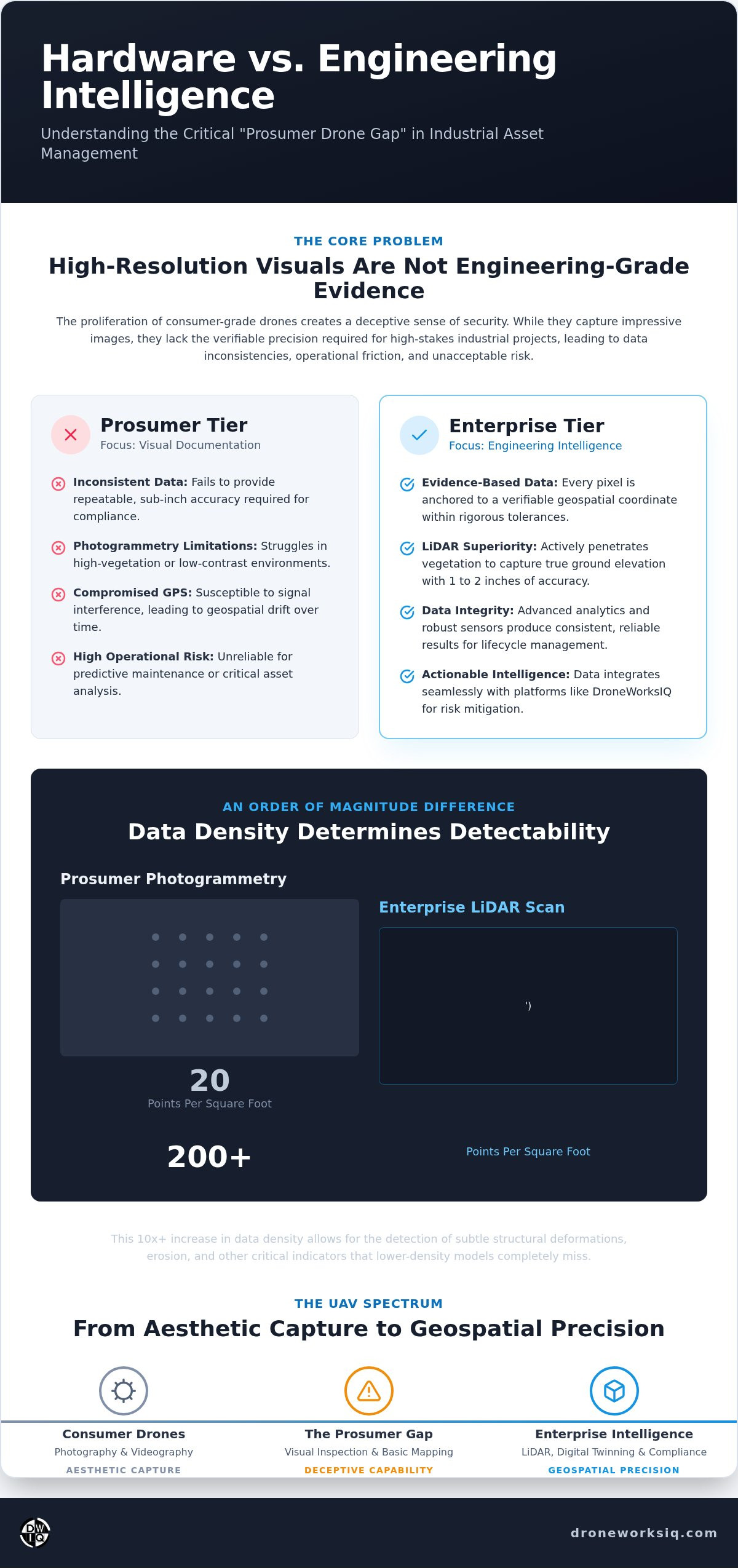
The prosumer commercial drone gap represents a critical technical and operational divide between high-end consumer unmanned aerial vehicles (UAVs) and sophisticated enterprise-grade aerial intelligence systems. In 2026, the proliferation of hardware priced under $10,000 has cultivated a deceptive sense of security among engineering firms. These platforms offer impressive visual resolution but lack the underlying engineering intelligence required for high-stakes industrial asset management. The systemic integration of high-resolution visual sensors with consumer-grade flight controllers often produces a veneer of professional capability that obscures significant technical deficits.
The distinction lies in the transition from visual documentation to the capture of evidence-based engineering data. While a prosumer platform might generate a visually coherent map, it often fails to provide the repeatable spatial accuracy necessary for compliance or predictive maintenance. Enterprise-grade systems prioritize data integrity over aesthetic capture. They ensure that every pixel is anchored to a verifiable geospatial coordinate within rigorous tolerances, transforming raw imagery into a reliable asset for the entire lifecycle of a project.
Key Takeaway: Visual representation is not a substitute for spatial accuracy. Engineering-grade intelligence requires verifiable precision that exceeds the capabilities of standard prosumer hardware.
The evolution of the prosumer drone
Hardware iterations have significantly narrowed the gap in raw visual performance. Modern prosumer sensors frequently utilize 1-inch CMOS chips and basic Real-Time Kinematic (RTK) modules. However, these improvements often fail to address the fundamental data precision gap. GPS accuracy in industrial environments is frequently compromised by signal interference or multi-path errors that consumer-grade flight controllers cannot effectively mitigate. This leads to data drift and inconsistencies across different flight missions.
True enterprise intelligence relies on the integration of high-grade sensors with robust geospatial analytics. Maintaining a consistent flight altitude of 200 feet requires more than standard barometric sensors; it necessitates advanced terrain-following capabilities and high-frequency data logging. Prosumer systems lack the technical depth to bridge the chasm between raw imagery and the actionable intelligence required for infrastructure lifecycle management. Relying on these tools for critical asset analysis introduces unacceptable levels of operational risk.
The Technical Deficit: Visual Data vs. Engineering Intelligence
Standard photogrammetry, the primary reconstruction method for most prosumer hardware, encounters significant failure points in high-vegetation or low-contrast environments. The prosumer commercial drone gap becomes evident when visual stitching algorithms struggle to identify tie points on homogenous surfaces or through dense canopy. Enterprise-grade LiDAR systems bypass these limitations by utilizing active light pulses to penetrate vegetation and capture true ground elevation within 1 to 2 inches of accuracy. This technical distinction is crucial for utility and pipeline inspection services where sub-surface terrain data is a prerequisite for engineering compliance.
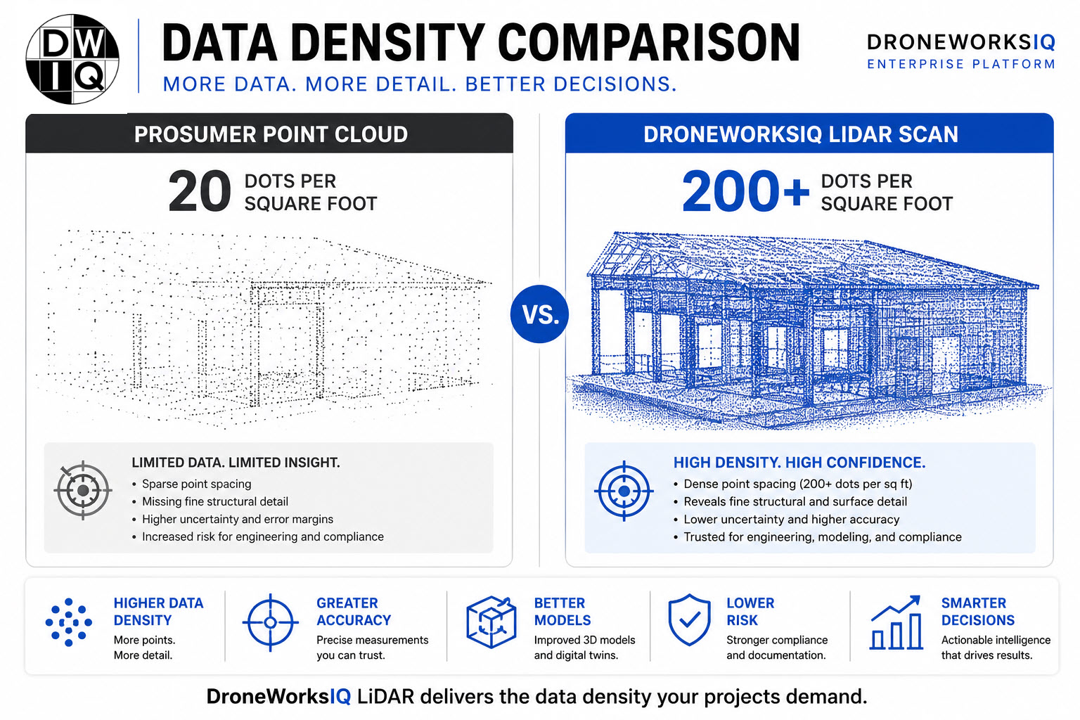
The disparity in data density further separates consumer-grade hardware from industrial intelligence systems. While prosumer photogrammetry may generate 20 points per square foot, enterprise LiDAR scans routinely exceed 200 points per square foot. This order-of-magnitude difference allows for the detection of subtle structural deformations that lower-density models overlook. Prosumer systems lack the sensor stability to produce identical results across a 12-month asset lifecycle. Variations in lens calibration and atmospheric conditions lead to geospatial drift, rendering long-term predictive maintenance models unreliable. Firms seeking to eliminate these technical deficits often transition to comprehensive LiDAR data collection and analysis.
Key Takeaway: High-density LiDAR capture provides the 200+ points per square foot required for structural integrity analysis, whereas prosumer visual data remains limited by environmental contrast and surface vegetation.
Sensor limitations and geospatial drift
The prevalence of rolling shutters and non-calibrated lenses in prosumer units introduces geometric distortion during high-speed flight missions. This distortion creates cumulative measurement errors that compromise the integrity of a digital twin. Without the precision of industrial-grade inertial measurement units (IMUs), prosumer hardware suffers from geospatial drift. This lack of absolute positioning accuracy prevents the reliable alignment of data sets captured at different intervals.
The AI-driven analytics requirement
Raw data represents a significant liability if it lacks structured interpretation. Transforming high-density point clouds into engineering intelligence requires AI-driven geospatial analytics for automated feature extraction. The ability to autonomously identify encroaching vegetation or structural anomalies is what bridges the gap between a simple image and a strategic asset management tool. Without these advanced analytical layers, raw aerial data remains an unrefined resource rather than a decision-making instrument.
Operational Risks: When 'Good Enough' Data Fails Compliance
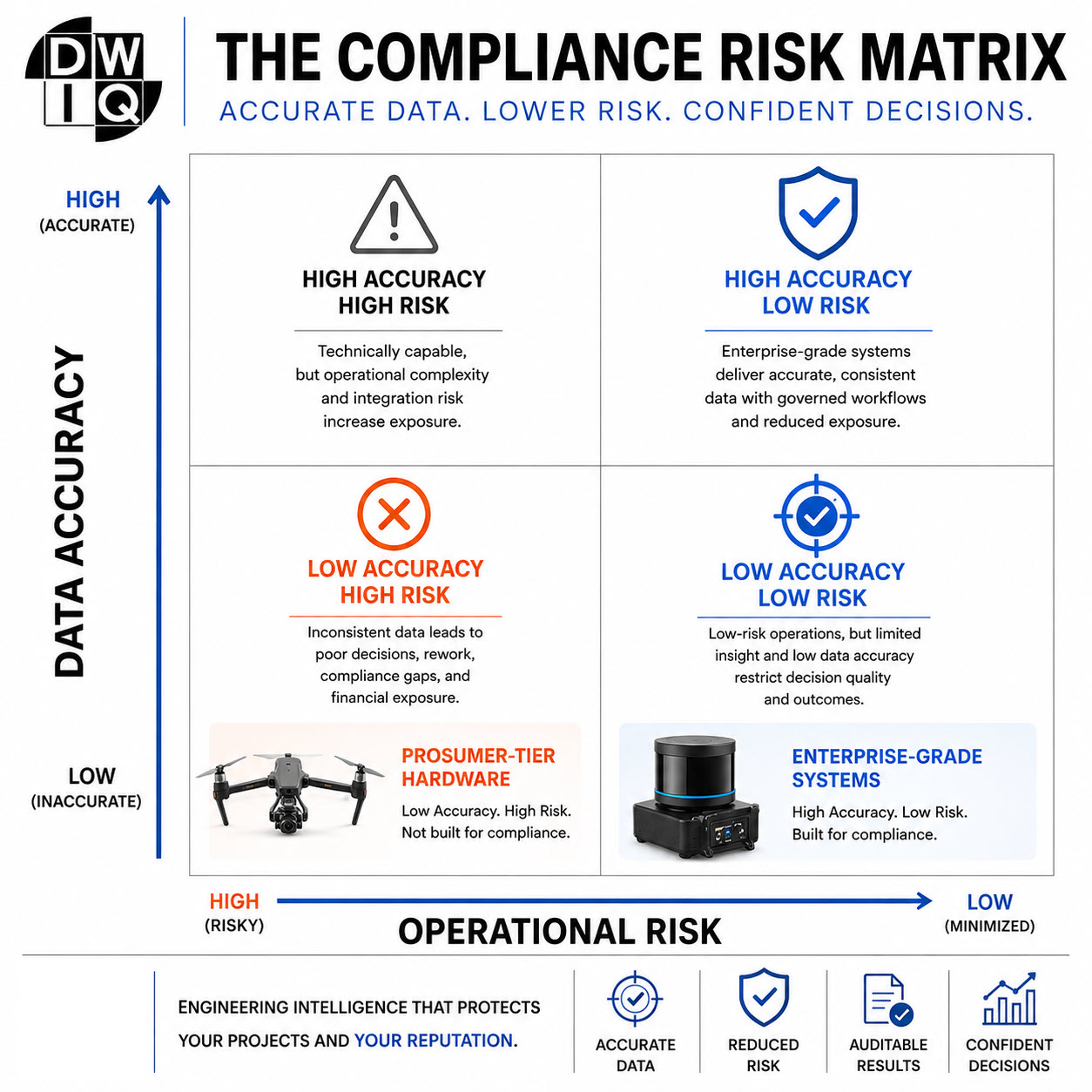
The utilization of sub-standard aerial data in critical infrastructure projects introduces systemic vulnerabilities that extend beyond simple measurement errors. In the context of the prosumer commercial drone gap, the legal and financial implications of utilizing non-compliant datasets for pipeline or facade inspections are substantial. When data lacks the evidence-based rigor required by national standards, the resulting models can't support defensible decision-making. This failure often necessitates expensive project delays as teams are forced to re-fly missions to capture the missing engineering intelligence.
Asset lifecycle management depends on the longitudinal consistency of data. Prosumer systems, which lack industrial-grade calibration, produce inconsistent results that prevent the development of accurate predictive maintenance models. If the baseline data for a digital twin drifts by even a few inches over a 12-month period, the ability to monitor structural erosion or deformation is compromised. Reliable oversight requires a platform that ensures data repeatability across every phase of the project lifecycle.
Key Takeaway: Operational reliability in asset management requires data that meets rigorous compliance standards; "good enough" data results in increased liability and unrecoverable project costs.
Infrastructure inspection protocols
Adherence to infrastructure inspection standards ensures that every flight mission delivers actionable engineering data rather than mere visual documentation. National utilities require evidence-based information that integrates directly into existing geospatial workflows. Achieving this level of precision requires the DroneWorksIQ Platform to bridge the gap between raw capture and strategic oversight.
Safety and reliability in high-stakes environments
Industrial-grade flight controllers provide the electromagnetic interference (EMI) shielding necessary for operations near high-voltage lines. Consumer-grade units often lack the redundancy required for autonomous aerial data collection in these high-stakes environments. Ensuring the safety of large-scale infrastructure projects requires hardware and software ecosystems designed for reliability under extreme operational constraints. To secure your project's data integrity, consider the advantages of Utility and Pipeline Inspection Services.
Bridging the Gap with the DroneWorksIQ Engineering Platform
Resolving the prosumer commercial drone gap requires a systemic shift in focus from flight platforms to analytical frameworks. While hardware selection remains a component of mission success, the primary strategic value lies in the transformation of raw geospatial data into actionable engineering intelligence. The DroneWorksIQ Platform facilitates this transition by providing a unified environment for mission planning, high-precision measurement, and asset lifecycle management. This approach effectively mitigates the risks of data fragmentation, ensuring that aerial captures integrate seamlessly with existing enterprise asset management software.
Strategic oversight is achieved through the synthesis of advanced sensor technology and specialized geospatial consulting. Moving beyond the limitations of standard UAV hardware, DroneWorksIQ utilizes AI-driven analytics to extract critical features from complex datasets. This methodology converts high-density point clouds into structured information. It allows technical decision-makers to prioritize maintenance based on empirical evidence rather than visual estimation. By centralizing these processes, firms can maintain a consistent data-to-decision workflow across diverse infrastructure projects.
Key Takeaway: The DroneWorksIQ Platform serves as the critical link between raw aerial capture and the high-fidelity intelligence required for industrial-grade asset lifecycle management.
Building high-fidelity digital twins
The creation of a comprehensive infrastructure digital twin relies on the rigorous integration of LiDAR and photogrammetry. These high-fidelity models support confident decision-making throughout the construction and operational phases. Repeatable data capture ensures that progress monitoring remains accurate, providing a verifiable record of site evolution. This is essential for construction intel and erosion monitoring services where baseline comparisons must remain precise over several years.
Transforming data into confidence
DroneWorksIQ delivers evidence-based reports designed specifically for executive oversight and regulatory compliance. Closing the technical gap is ultimately a matter of selecting a partner capable of handling the complexities of high-stakes data environments with methodical accuracy. The aircraft is merely a sensor delivery system; the platform is the engine of insight. Transform your drone data into engineering intelligence with DroneWorksIQ.
Advancing Toward Engineering-Grade Intelligence
The transition from aesthetic visual capture to rigorous engineering intelligence requires a fundamental recalibration of technical standards. This analysis has detailed the systemic deficiencies inherent in the prosumer commercial drone gap, where the absence of industrial-grade precision introduces unmanageable operational risks. High-density LiDAR systems and AI-driven geospatial insights are the only viable methodologies for maintaining the repeatable accuracy required for national infrastructure projects. It's clear that hardware alone can't bridge the divide between raw imagery and actionable data.
Securing long-term asset lifecycle integrity depends on the integration of evidence-based data into established engineering workflows. DroneWorksIQ provides the technical prowess and national service coverage necessary to eliminate data inconsistency and ensure regulatory compliance. By prioritizing sophisticated analytical frameworks over basic hardware, your organization achieves the comprehensive oversight required for high-stakes industrial applications. Transform your aerial imaging into actionable infrastructure intelligence with DroneWorksIQ. We're ready to assist in the evolution of your geospatial data strategy.
Frequently Asked Questions
What is the primary difference between a prosumer and an enterprise drone for commercial use?
The distinction centers on the integration of engineering-grade sensors and robust inertial measurement units (IMUs). Prosumer platforms prioritize visual resolution for documentation, whereas enterprise systems emphasize geospatial accuracy and data repeatability. This technical divergence ensures that enterprise drones maintain sub-inch precision across multiple flight missions, providing the evidence-based data required for strategic industrial applications.
Can prosumer drones be used for high-accuracy LiDAR data collection?
No, prosumer drones generally lack the payload capacity and electrical architecture necessary to operate high-density LiDAR sensors. While some mid-tier units offer basic laser scanning, they can't achieve the 200+ points per square foot density required for detailed structural analysis. True engineering intelligence requires specialized LiDAR hardware that penetrates dense vegetation to capture true ground elevation within 1 to 2 inches of accuracy.
How does the 'Prosumer Gap' affect the ROI of a drone program?
The prosumer commercial drone gap erodes program ROI by necessitating frequent re-flights and manual data reconciliation. When initial captures lack the precision for automated analysis, the operational efficiency of the geospatial workflow collapses. Enterprise systems eliminate these hidden costs by delivering repeatable, high-fidelity data that integrates directly into asset management software, streamlining the transition from raw capture to executive decision-making.
What are the compliance risks of using consumer-grade aerial data for infrastructure?
Using sub-standard data for pipeline or facade inspections creates significant legal and safety liabilities. Consumer-grade systems often fail to meet the rigorous geospatial standards mandated for national infrastructure projects, resulting in non-compliant documentation. This lack of precision compromises predictive maintenance models, potentially leading to undetected structural failures and unmitigated operational risks in high-stakes environments.
Is photogrammetry sufficient for creating an engineering-grade digital twin?
Photogrammetry is often insufficient for high-fidelity digital twinning in complex environments. While effective for basic 3D modeling on clear sites, it fails to provide accurate terrain data in high-vegetation or low-contrast areas. Engineering-grade digital twins require the integration of LiDAR to ensure that ground elevation and structural dimensions are captured with absolute geospatial certainty, regardless of environmental conditions.
Originally published by DroneWorksIQ. Legacy source.