
INSIGHTS
Construction Site Drone Mapping: An Enterprise Operational Readiness Checklist
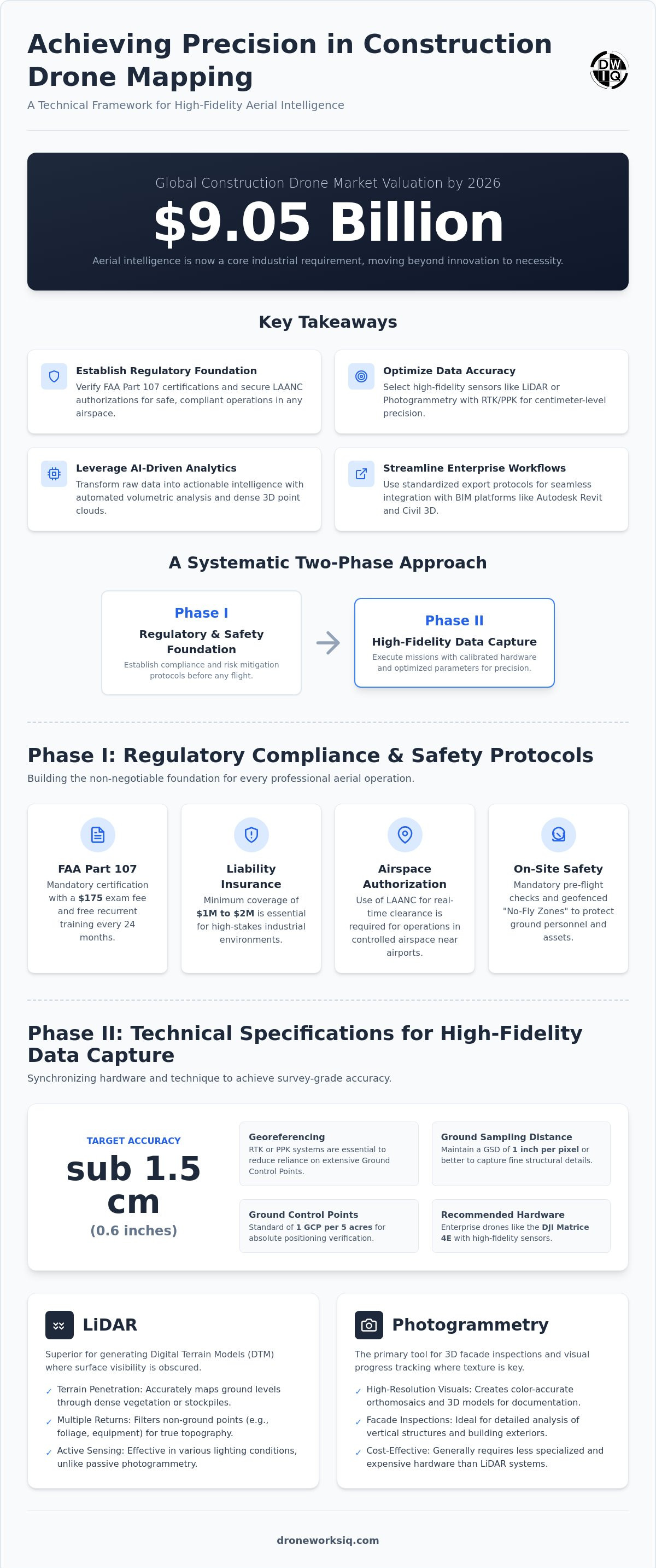
By 2026, the global construction drone market has reached a $9.05 billion valuation, confirming that aerial intelligence is no longer a peripheral innovation but a core industrial requirement. Enterprise project managers understand that traditional survey methodologies often yield fragmented data and inconsistent measurements, which frequently result in expensive rework and schedule delays. Achieving accuracy within less than one inch through construction site drone mapping requires more than hardware acquisition; it demands a rigorous convergence of regulatory compliance and systematic data processing.
This article delivers a comprehensive technical framework for the deployment of autonomous aerial intelligence to ensure operational precision and full FAA compliance. Readers will gain a standardized operational checklist designed to eliminate data silos and facilitate the seamless integration of high-fidelity geospatial insights into existing BIM workflows. We examine the critical parameters for hardware selection, the $175 FAA Part 107 testing requirements, and the specific protocols necessary for maintaining high-resolution accuracy across complex project environments. This systematic approach ensures that aerial data becomes a reliable asset for strategic industrial application.
Phase I: Regulatory Compliance and Safety Protocols
Establishing a rigorous regulatory foundation is the primary requirement for any enterprise aerial program. Every operator must hold a valid FAA Part 107 certificate, which involves a $175 initial examination fee and mandatory free recurrent training every 24 months. Enterprise construction site drone mapping necessitates strict adherence to the Remote ID mandate and NDAA compliance regarding hardware origin. Failure to verify these credentials introduces significant legal liability and operational risk to the project stakeholders. Documentation of these certifications forms the first layer of the operational readiness checklist.
Insurance requirements for industrial environments typically mandate a minimum of $1 million to $2 million in liability coverage. This protection is essential for high-stakes environments where autonomous systems operate in proximity to expensive machinery and structural assets. Operational frameworks must also include documented emergency bypass procedures for autonomous flight paths. These protocols ensure that technical failures or telemetry loss don't result in catastrophic incidents over active work zones. Precision in these safety standards ensures that data collection remains a controlled, professional endeavor rather than a liability.
Airspace Authorization and Legal Framework
Industrial projects frequently intersect with controlled airspace, requiring the use of the Low Altitude Authorization and Notification Capability (LAANC) for real-time clearance. Complex mapping involving Photogrammetry near sensitive infrastructure or residential zones requires site-specific privacy protocols. These measures prevent unauthorized data capture and ensure compliance with local ordinances. Standardizing these legal workflows is critical for maintaining the integrity of drone inspection reporting services across multiple jurisdictions.
On-Site Safety and Risk Mitigation
Rigorous pre-flight inspections are mandatory for every mission to ensure the safety of the construction site drone mapping operation. Checklists must cover sensor calibration, propulsion system integrity, and telemetry signal strength to prevent mid-flight malfunctions. Defining "No-Fly Zones" within the construction perimeter protects ground personnel and equipment from aerial activity. These zones are programmed directly into the flight management software as geofences, providing a redundant safety layer that complements human oversight. This systematic approach transforms raw flight operations into a reliable, enterprise-grade data acquisition process.
Phase II: Technical Specifications for High-Fidelity Data Capture
High-fidelity data acquisition is contingent upon the precise synchronization of sensor modality and georeferencing hardware. For effective construction site drone mapping, the selection between photogrammetry and LiDAR determines the actionable utility of the resulting geospatial model. While photogrammetry provides high-resolution visual orthomosaics suitable for site documentation, LiDAR's active sensing capabilities are required for terrain penetration in areas with dense vegetation or complex stockpiles. This choice dictates the entire downstream processing workflow and the quality of the final deliverables.
Achieving centimeter-level accuracy necessitates the implementation of Real-Time Kinematic (RTK) or Post-Processed Kinematic (PPK) workflows. These systems reduce reliance on extensive Ground Control Point (GCP) arrays, although a target density of one GCP per 5 acres remains the standard for absolute positioning verification. Flight parameters must be configured to maintain a Ground Sampling Distance (GSD) of 1 inch per pixel or better. This level of resolution ensures that fine structural details and site anomalies are captured with sufficient clarity for technical analysis. Research into Drone-Based Orthoimagery and Deep Learning emphasizes that such high-resolution inputs are fundamental for the automated feature extraction and classification required in modern industrial applications.
LiDAR vs. Photogrammetry in Construction
LiDAR is the superior modality for generating digital terrain models (DTM) where surface visibility is obscured. Its ability to record multiple returns allows for the filtering of non-ground points, providing an accurate representation of the underlying topography. Photogrammetry remains the primary tool for 3D facade inspections and visual progress tracking, where color-accurate textures are prioritized. For projects requiring these specialized outputs, utilizing professional drone inspection reporting services ensures that construction site drone mapping data meets enterprise-grade specifications.
Hardware and Sensor Calibration
Sub-inch horizontal and vertical accuracy requires rigorous calibration of the Inertial Measurement Unit (IMU) and GNSS receiver before mission commencement. Any misalignment in these components introduces systemic errors that propagate through the processing pipeline. Projects involving utility corridor inspections often require the integration of multi-spectral or thermal sensors to identify subsurface anomalies or thermal leaks. These specialized sensors must be synchronized with the primary telemetry stream to maintain geospatial integrity across all data layers.
Phase III: Geospatial Data Processing and AI Analytics
The computational synthesis of raw telemetry into densified point clouds and high-fidelity 3D mesh models represents the critical processing phase of the enterprise workflow. This transformation necessitates the utilization of sophisticated photogrammetric engines capable of managing high-volume datasets while maintaining absolute geospatial integrity. Validation of these outputs against survey-grade benchmarks provides the empirical verification required for strategic decision-making. Through automated volumetric analysis, project stakeholders achieve precise stockpile oversight and earthwork monitoring, eliminating the inaccuracies inherent in manual measurement techniques.
Point Cloud Generation and Analysis
Executing aerial LiDAR data collection allows for the creation of high-fidelity digital twins even in topographically complex environments. Advanced filtering techniques are employed to remove non-ground points such as machinery, temporary structures, or vegetation, ensuring the digital terrain model accurately represents the surface. This level of detail is essential for precise engineering calculations and long-term site planning.
AI-Driven Geospatial Intelligence
Leveraging AI-driven geospatial analytics automates the identification of structural anomalies and safety violations through advanced computer vision. These systems detect deviations between as-built data and original BIM designs, allowing for immediate corrective action before errors escalate into costly rework. Computer vision algorithms also scan for safety hazards, such as missing guardrails or improper material storage, enhancing site-wide risk mitigation. This automated oversight transforms construction site drone mapping from a documentation tool into a proactive intelligence asset.
For organizations seeking to implement these advanced analytical frameworks, our Construction Intel solutions provide the technical infrastructure required for high-precision site monitoring.
Phase IV: Enterprise Integration and Reporting Standards
The final phase of the operational framework focuses on the transformation of geospatial data into enterprise-ready assets. Effective construction site drone mapping relies on rigorous export protocols to ensure seamless interoperability with primary design platforms like Autodesk Revit and Civil 3D. Standardizing these data formats allows for the direct ingestion of orthomosaics and point clouds into existing engineering workflows, facilitating as-built verification and clash detection. It's essential to prioritize data portability into third-party ERP and BIM systems, or project management platforms like GoBuid, to avoid the limitations of proprietary cloud silos that restrict cross-platform analysis.
Establishing a consistent cadence for aerial construction progress monitoring is vital for maintaining project momentum. While bi-weekly flights may suffice for slower-paced infrastructure projects, high-intensity urban developments often require weekly deployments to capture rapid site changes. This data then feeds into standardized drone inspection reporting services, providing executive stakeholders with high-level summaries and actionable intelligence that informs resource allocation and scheduling decisions.
Data security remains paramount. Sensitive infrastructure intelligence must be hosted within encrypted cloud environments that meet enterprise security standards. These repositories provide a centralized source of truth, ensuring that geospatial insights are accessible to multi-disciplinary teams while protecting intellectual property and site safety data. Robust access controls prevent unauthorized data manipulation, maintaining the integrity of the project record throughout the entire construction lifecycle.
BIM Integration and Digital Twin Synchronization
Maintaining a live infrastructure digital twin ensures that the virtual model reflects current site conditions with sub-inch precision. This synchronization allows project managers to overlay drone-captured data with original BIM designs to identify discrepancies instantly. Sharing these insights across multi-disciplinary project teams fosters collaborative problem-solving and reduces the risk of misaligned construction activities. It's a systematic approach that bridges the gap between field reality and office design.
Key Takeaway
Successful construction site drone mapping requires a holistic approach that treats data as a strategic asset rather than a simple visual aid.
Optimizing Industrial Geospatial Intelligence for Enterprise Scale
The transition from manual site monitoring to autonomous aerial intelligence represents a fundamental shift in industrial project management. Achieving high-fidelity results requires a systematic convergence of regulatory compliance, sensor precision, and computational analysis. Integrating construction site drone mapping into the core project lifecycle ensures that data remains an objective, verifiable asset for risk mitigation and as-built verification. Organizations that prioritize these technical frameworks secure a significant competitive advantage through enhanced measurement accuracy and streamlined BIM synchronization. It's a structured approach that eliminates data silos and facilitates real-time communication across multi-disciplinary project teams.
DroneWorksIQ provides the technical infrastructure necessary to deploy these advanced geospatial solutions across national infrastructure projects. Our methodology utilizes specialized LiDAR and AI-driven analytics to transform raw telemetry into actionable intelligence through autonomous data collection protocols. We ensure that your operational data meets the highest standards of precision and enterprise security. Consult with DroneWorksIQ for Enterprise Aerial Intelligence Solutions to begin your transition toward a data-driven construction environment. Precision is the foundation of structural integrity.
Frequently Asked Questions
What is the standard accuracy for construction site drone mapping?
Standard accuracy for enterprise construction site drone mapping typically reaches sub-inch horizontal and vertical precision when utilizing RTK or PPK georeferencing. Achieving a Ground Sampling Distance (GSD) of 1 inch per pixel or better is the baseline for high-fidelity structural analysis. This precision ensures that digital twins accurately reflect real-world site conditions for as-built verification and engineering analysis.
Can drone mapping replace traditional land surveying entirely?
Autonomous aerial intelligence serves as a high-density data supplement rather than a total replacement for traditional land surveying. While drones capture millions of data points across large areas with extreme efficiency, legal boundary determinations and official certifications require the oversight of a licensed professional surveyor. The integration of both methodologies provides the most comprehensive geospatial dataset for complex infrastructure projects.
How much does it cost to implement a drone mapping program on a large construction site?
Implementation costs vary based on project scale and the required sensor modalities like LiDAR or photogrammetry. Industry research for 2026 indicates that professional construction site drone mapping services typically range from $250 to $600 per hour, with per-acre rates falling between $5 and $25 depending on site complexity. Internal programs must also account for the $175 FAA Part 107 examination fee and the $5 drone registration cost per unit.
What are the FAA requirements for flying drones on construction sites?
Compliance requires all operators to maintain a current FAA Part 107 certificate and register drones weighing over 0.55 lbs for a $5 fee. As of 2026, Remote ID is mandatory and fully enforced for all commercial operations in the U.S. Pilots must also utilize LAANC for real-time airspace authorization when operating within controlled environments near airports or sensitive infrastructure.
How often should a construction site be mapped for progress monitoring?
Mapping frequency is dictated by the velocity of site activity and the specific requirements of the project management team. High-intensity urban developments typically require weekly mapping to maintain an accurate infrastructure digital twin and monitor rapid progress. Bi-weekly or monthly intervals may be sufficient for large-scale corridor projects or earthwork monitoring where terrain changes occur at a slower pace.
Originally published by DroneWorksIQ. Legacy source.