
INSIGHTS
DJI Drone Obsolescence: Impact on Commercial Mapping
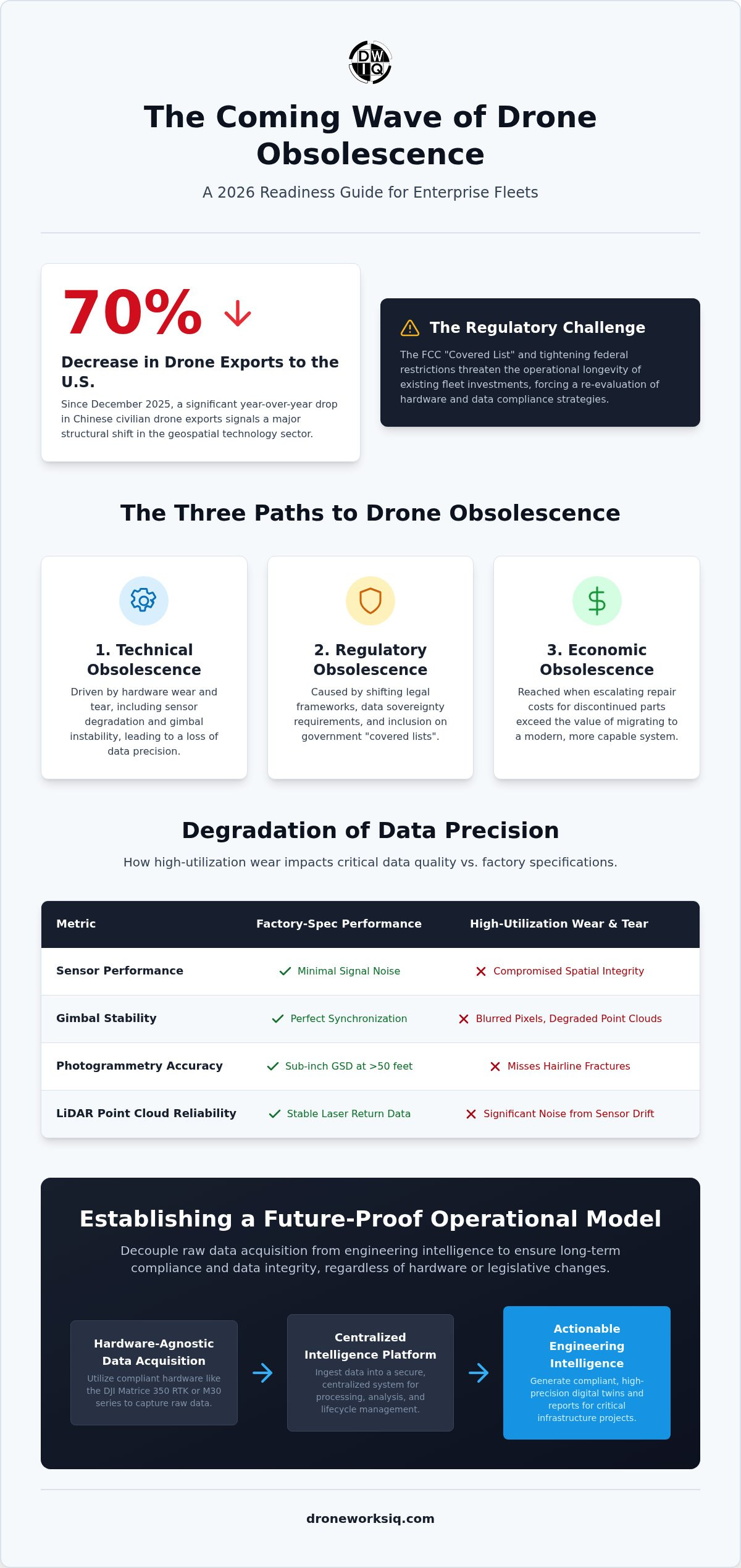
Since December 2025, Chinese customs data indicates a 70% year over year decrease in civilian drone exports to the United States, signaling a structural shift in the geospatial technology sector. You likely recognize that the period of rapid hardware acquisition is being replaced by a climate of DJI drone obsolesce, where regulatory constraints and the FCC "Covered List" threaten the longevity of existing fleet investments. This shift forces a critical re-evaluation of how enterprise organizations maintain operational readiness amidst tightening federal restrictions on new equipment authorizations.
We provide a clinical examination of the technical and strategic factors defining current hardware lifecycles to ensure your aerial data remains a functional asset rather than a depreciating liability. You will gain a clear understanding of the 2026 drone regulations and a methodical roadmap for migrating toward engineering-grade intelligence platforms. This guide details the transition from hardware-centric workflows to data-driven oversight, ensuring compliance and data integrity across critical infrastructure projects regardless of future legislative volatility.
Key Takeaways
Differentiate between functional flight status and strategic data compliance to identify hidden liabilities within an aging aerial fleet.
Quantify the technical impact of sensor degradation and gimbal instability on maintaining sub-inch (less than 1 inch) precision for complex digital twinning.
Analyze the 2026 regulatory landscape to mitigate the operational risks of DJI drone obsolesce and ensure alignment with federal data sovereignty requirements.
Establish a future-proof operational model by decoupling raw data acquisition from centralized engineering intelligence and asset lifecycle management.
The Multi-Faceted Nature of DJI Drone Obsolescence
Enterprise drone obsolescence is not a singular event but a convergence of mechanical degradation, software-defined limitations, and shifting regulatory frameworks. While a Unmanned aerial vehicle (UAV) might remain mechanically sound, it enters a state of DJI drone obsolesce when its output no longer aligns with rigorous industrial standards. This process involves the intersection of hardware wear and the external pressures of a rapidly evolving geospatial ecosystem.
Distinguishing between functional and strategic failure is critical for fleet management. A unit is functionally obsolete when physical components, such as motors or circuit boards, fail beyond repair. Conversely, strategic DJI drone obsolesce occurs when the hardware remains flight-capable but the captured data fails to meet updated compliance protocols or security requirements. In high-stakes environments like utility inspections, a drone that flies but cannot provide secure, unencrypted data streams is a liability.
Software and Firmware Lock-ins
Mandatory firmware updates often act as a catalyst for obsolescence by introducing restrictive geofencing or altering data extraction capabilities without prior notice. These software-level changes can suddenly render a fleet ineligible for specific project sites. Proprietary data formats further complicate the landscape, as hardware-integrated clouds may limit the long-term portability of digital twin assets, creating silos that hinder cross-platform engineering analysis.
The Economic Threshold of Repair
Calculating the return on investment for aging hardware requires a clinical assessment of repair costs against the capabilities of modern LiDAR-integrated systems. Maintaining a legacy Matrice unit often involves escalating costs for discontinued parts and specialized labor. The average enterprise drone lifespan is 36 to 48 months for high-utilization assets. When maintenance expenses approach the cost of migrating to a hardware-agnostic platform, the economic threshold of obsolescence has been reached.
Key Takeaway: In 2026, enterprise obsolescence is primarily driven by data security standards and sensor precision requirements rather than simple mechanical failure.
Technical Lifecycle Analysis: Sensor Degradation and Data Precision
Sensor performance is not static. Environmental stressors and operational vibration induce subtle lens calibration shifts that compromise spatial integrity over time. While a unit may appear operational, the accumulation of sensor noise prevents it from meeting the stringent 2026 engineering standards required for national infrastructure projects. This technical decline represents a core driver of DJI drone obsolesce, where the hardware's inability to provide repeatable, evidence-based data renders it unsuitable for high-stakes geospatial analysis.
Maintaining sub-inch (less than 1 inch) accuracy for complex digital twinning relies heavily on gimbal stability and sensor synchronization. Older enterprise models often exhibit increased mechanical play in the gimbal assembly, leading to blurred pixels and degraded point cloud density. Organizations must evaluate whether legacy hardware still supports the precision levels necessary for high-fidelity digital twinning services. This evaluation is essential as DJI drone obsolesce often manifests as a slow erosion of data reliability rather than a sudden mechanical failure.
Photogrammetry Accuracy at Scale
Legacy 20-megapixel sensors frequently fail to satisfy current requirements for facade inspections when operating at distances exceeding 50 feet. The resulting Ground Sample Distance (GSD) lacks the resolution to detect hairline fractures or minor structural anomalies. Repeatable GSD is mandatory for longitudinal erosion monitoring and construction site progress, necessitating hardware that maintains factory-spec calibration throughout its lifecycle. High-resolution sensors are now the baseline for any project involving critical infrastructure oversight.
LiDAR Point Cloud Reliability
Sensor drift in aging LiDAR units introduces significant noise into infrastructure intelligence models, complicating the detection of subtle geometric changes. Precise LiDAR point cloud analysis requires stable laser return data that legacy systems struggle to provide. A recent drone mapping accuracy study confirms that data precision is highly dependent on sensor age and maintenance history, making hardware lifecycle management a critical component of data reliability.
Key Takeaway: Technical obsolescence is measured by the degradation of data precision, where sensor noise and gimbal instability prevent hardware from achieving the sub-inch accuracy required for 2026 engineering standards.
Regulatory Obsolescence: Navigating the 2026 Legal Landscape
The regulatory landscape of 2026 has transformed the definition of fleet longevity. DJI drone obsolesce is now a function of federal compliance rather than mechanical wear. Following the FCC’s inclusion of DJI on its "Covered List" on December 23, 2025, new hardware authorizations have ceased, creating a hard ceiling for fleet expansion with legacy vendors. Organizations operating near critical infrastructure must now navigate the FAA's proposed rules for fixed-site restrictions, which anticipate over 9,000 restriction applications within the first five years of implementation.
Data sovereignty requirements are driving a mass migration away from hardware-integrated cloud ecosystems. Enterprise clients now demand that sensitive geospatial data be processed on isolated, domestic platforms to prevent unauthorized data transmission. This shift is mandatory for utility and pipeline inspection services on federal land, where non-compliant hardware can result in immediate contract termination or legal sanctions. A methodical fleet-wide compliance audit is the only way to identify high-risk assets before they impact project delivery.
The Shift Toward NDAA-Compliant Alternatives
Transitioning to domestic or allied hardware requires a clinical assessment of lifecycle costs. While the initial investment in Blue UAS platforms is often higher, the long-term value resides in the data analysis platform rather than the airframe. Organizations that prioritize platform-agnostic intelligence maintain operational continuity even as specific hardware models face increasing federal scrutiny. Ensure your operations remain compliant by leveraging our specialized utility and pipeline inspection services designed for high-security environments.
Insurance and Liability Gaps
Insurance underwriters are recalibrating premiums to reflect the heightened risk of non-compliant hardware. Using equipment that lacks current FCC authorization or fails data sovereignty tests creates a significant liability gap. In construction and infrastructure sectors, the legal necessity for evidence-based data means that any compromise in hardware compliance can invalidate inspection results during litigation, making "obsolete" hardware a primary business risk.
Key Takeaway: Regulatory obsolescence is an immediate operational threat where non-compliance with NDAA standards or FCC authorizations can lead to insurance denials and the loss of federal contracts.
Mitigating the recurring cycle of DJI drone obsolesce requires a fundamental shift from hardware-centric operations to a data-driven intelligence model. Enterprise strategy must adopt a three-phase architectural transformation to ensure long-term data viability. Phase 1 involves decoupling raw data acquisition from the analysis layer, ensuring that the utility of captured information isn't tethered to specific hardware lifecycles. Phase 2 requires the implementation of a centralized infrastructure intelligence platform to manage asset lifecycles through a unified data environment. Finally, Phase 3 standardizes on engineering-grade deliverables, such as high-density 3D models and LiDAR point clouds, rather than ephemeral raw imagery.
Leveraging DroneWorksIQ for Future-Proofing
The DroneWorksIQ platform functions as a hardware-agnostic bridge, transforming raw data from any compliant aerial system into repeatable engineering intelligence. By utilizing AI-driven analytics, organizations can maintain comprehensive asset documentation across a 10-year lifecycle, regardless of the specific sensors used during initial collection. This clinical approach ensures that the intelligence asset remains functional even after the physical aircraft has reached its technical or regulatory end-of-life.
Implementing a Hardware-Agnostic Workflow
Successful integration of diverse aerial data sources into a single, cohesive digital twin model allows firms to maintain continuity across evolving fleet standards. Strategic managers are increasingly moving toward "Project-Based Aerial Data Collection" to bypass the capital expenditure risks associated with hardware ownership. This model prioritizes the outcome over the tool, utilizing specialized Enterprise Drone Mapping Services to ensure data precision while insulating the organization from the volatility of DJI drone obsolesce.
Physical hardware will always obsolesce as sensors degrade and regulations tighten. However, engineering intelligence processed through a sophisticated analysis platform remains a permanent, appreciating asset for the enterprise.
Key Takeaway: True operational resilience is achieved by shifting focus from hardware ownership to engineering intelligence, where data value is preserved across multiple hardware generations through a centralized, hardware-agnostic platform.
Securing Operational Continuity through Engineering Intelligence
Managing a commercial fleet requires a clinical recognition that hardware is a transient tool while data remains a permanent enterprise asset. You've seen how technical degradation and shifting regulatory frameworks accelerate DJI drone obsolesce, making it imperative to prioritize data sovereignty and sensor precision. By decoupling raw acquisition from centralized analysis, organizations insulate themselves from the volatility of hardware lifecycles and ensure compliance with evolving federal standards.
DroneWorksIQ provides the technical bridge between raw aerial collection and evidence-based decision-making. Our hardware-agnostic platform delivers accurate, repeatable results for asset lifecycle management while minimizing the risks associated with non-compliant equipment. Through expert geospatial consulting, we ensure your operations remain aligned with the highest engineering and regulatory requirements. Transform your aerial data into engineering intelligence with DroneWorksIQ and secure your operational future.
Frequently Asked Questions
What is the average lifespan of a DJI enterprise drone in a professional environment?
High-utilization DJI enterprise drones typically maintain peak operational efficiency for 36 to 48 months. This lifecycle is primarily limited by battery chemistry degradation, motor bearing wear, and the gradual misalignment of optical sensors during high-frequency flight operations. While a unit may remain flight-capable beyond this window, the precision of the geospatial output often falls below the rigorous thresholds required for engineering-grade digital twinning and infrastructure analysis.
How does the Countering CCP Drones Act affect my existing DJI fleet in 2026?
In 2026, the primary impact of federal legislation is the prohibition of new hardware authorizations under the FCC "Covered List" established on December 23, 2025. Existing fleets remain legal for operation if they were authorized before the cutoff date, though firmware updates are only guaranteed through 2029. Organizations must prepare for restricted access to federal contracts and critical infrastructure sites as security protocols tighten around non-domestic hardware.
Can I still use DJI drones for private construction progress monitoring?
You can still utilize DJI hardware for private construction monitoring, provided the project site is not designated as critical infrastructure under FAA proposed rules. The risk in this sector is less about absolute legal bans and more about insurance coverage and data sovereignty. Using equipment that contributes to DJI drone obsolesce may increase liability if the captured data is used for legal site progress documentation or evidence-based reporting.
What is the difference between functional and regulatory obsolescence?
Functional obsolescence refers to the physical failure of hardware components, whereas regulatory obsolescence occurs when equipment remains operational but becomes legally or contractually non-compliant. A drone with perfectly functioning motors is strategically obsolete if its data transmission protocols violate federal security standards or if it lacks current FCC authorization. This distinction is vital for maintaining a fleet that serves as a compliant asset rather than an operational liability.
How can I future-proof my drone data against hardware changes?
Future-proofing requires decoupling raw data collection from your centralized analysis and intelligence platform to ensure data longevity. By implementing a hardware-agnostic workflow, you ensure that geospatial assets remain accessible and functional regardless of changes in the drone market. This strategy transforms aerial data into a permanent engineering asset that outlives the specific aircraft used for initial acquisition, effectively mitigating the impact of DJI drone obsolesce.
Is LiDAR more resistant to obsolescence than standard photogrammetry?
LiDAR sensors are generally more resistant to strategic obsolescence because they provide high-density, direct-measurement data that meets 2026 engineering standards across diverse environments. While standard photogrammetry relies on optical sensor quality that degrades over time, LiDAR's structural point clouds offer superior repeatability for asset lifecycle management. However, the mechanical components of LiDAR units still face functional wear similar to standard optical payloads, requiring regular calibration to maintain sub-inch precision.
Originally published by DroneWorksIQ. Legacy source.