
INSIGHTS
Enterprise Drone Surveying Companies: A Strategic Selection Guide for 2026
The strategic value of enterprise drone surveying companies in 2026 is defined by analytical intelligence rather than basic flight capabilities. While the construction drone sector has expanded to a $4.99 billion market, many technical decision-makers still face project disruptions caused by inaccurate geospatial data. You've likely encountered the friction of attempting to integrate raw aerial outputs into rigid BIM or GIS workflows. Selecting a partner without specialized LiDAR expertise poses a significant risk to infrastructure integrity and project timelines.
This guide presents a methodical framework for the evaluation of aerial intelligence partners based on technical precision and AI-driven geospatial analytics. We define the requirements for achieving centimeter-level accuracy, specifically maintaining tolerances within 0.5 inches for high-stakes engineering applications. You'll gain a comprehensive understanding of how to secure high-resolution 3D models through the seamless integration of LiDAR and photogrammetry data. We examine the operational implications of the finalized FAA Part 108 regulations for Beyond Visual Line of Sight (BVLOS) missions and the necessity of cloud-based processing for streamlined infrastructure intelligence.
Key Takeaways
Evolve beyond rudimentary mapping into advanced aerial intelligence by prioritizing the synthesis of autonomous data acquisition and high-resolution geospatial analysis.
Utilize a technical framework for evaluating drone surveying companies that emphasizes LiDAR point cloud density and AI-driven feature extraction efficacy.
Determine optimal sensor modalities through the comparative analysis of light-based detection physics and image-based reconstruction for complex infrastructure environments.
Maximize operational ROI by integrating digital twinning and erosion monitoring services into existing enterprise BIM and GIS workflows.
The Evolution of Aerial Intelligence: Beyond Basic Drone Mapping
The current geospatial environment demands a transition from rudimentary aerial photography to sophisticated aerial intelligence. This paradigm shift defines aerial intelligence as the rigorous synthesis of high-resolution data acquisition and autonomous computational analysis. Leading drone surveying companies have moved beyond simple visual captures to provide comprehensive infrastructure intelligence. This evolution is driven by the necessity for precision in national infrastructure management, where standard imagery lacks the depth required for complex engineering decisions.
While a traditional unmanned aerial photogrammetric survey remains effective for high-contrast surface mapping, it often fails in environments with dense canopy or complex vertical structures. Advanced LiDAR data collection utilizes active laser pulses to penetrate vegetation and capture precise topography, providing a level of detail that passive sensors cannot replicate. This technical distinction is critical for utility and pipeline inspection services where sub-inch accuracy is mandatory for structural integrity assessments.
Autonomous aerial systems now function as the primary mechanism for generating high-fidelity digital twins. By removing the variability of manual piloting, these systems eliminate human error and significantly reduce operational risk in high-hazard zones. The result isn't just a visual record; it's a dynamic, spatially accurate model that supports predictive maintenance and long-term asset oversight across expansive industrial sites.
The Shift from Collection to Geospatial Analysis
Raw imagery serves as an incomplete dataset for enterprise-scale operations. Modern surveying workflows prioritize the transformation of pixel and point data into actionable infrastructure intelligence through AI-driven analytics. This process involves automated feature extraction and change detection, allowing for the rapid identification of structural anomalies. Drone surveying companies that implement these advanced software stacks move the value proposition from data delivery to strategic insight. This ensures that every flight contributes directly to the optimization of infrastructure lifecycles and the reduction of long-term maintenance costs.
For specialized surveying firms aiming to showcase their technical expertise to a local market, a strong online presence is a key differentiator. To explore how small businesses can enhance their digital visibility and reach regional decision-makers, visit KD Interactive for professional SEO insights.
Technical Selection Criteria for Drone Surveying Partners
Establishing technical veracity is the primary objective when vetting drone surveying companies for enterprise-scale operations. A methodical evaluation framework prioritizes sensor precision and data integrity over basic operational metrics, a standard upheld by experienced firms like Hill & Blume. Technical decision-makers must demand empirical proof of sensor calibration and point cloud density to ensure that subsequent geospatial analytics are based on high-fidelity datasets.
Assessing LiDAR and Sensor Sophistication
LiDAR performance is a critical differentiator in complex environments. Partners must provide technical specifications detailing their sensors' ability to penetrate dense vegetation, such as maintaining ground-point resolution through 6 inches of canopy cover. Achieving Enterprise Drone Mapping Accuracy depends on the rigorous application of RTK and PPK technologies to secure sub-inch vertical precision. Regular sensor calibration intervals are mandatory to prevent drift and ensure consistent data quality across multi-year infrastructure projects.
Compliance and safety protocols represent the secondary tier of selection criteria. All commercial operators must hold FAA Part 107 certificates and adhere to Remote ID enforcement standards. For large-scale assets, scalability is essential. Leading drone surveying companies demonstrate the capacity to manage national-level data collection across diverse geographic locations while adhering to centralized data governance standards. Organizations often utilize professional LiDAR data collection and analysis to maintain these high standards of precision across their asset portfolios.
Workflow Integration and Data Interoperability
The utility of aerial data is contingent upon its seamless integration into established engineering workflows. Modern surveying deliverables must support direct interoperability with GIS, BIM, and CAD environments to avoid the friction of manual data conversion. Cloud-based infrastructure intelligence platforms are necessary for providing stakeholders with immediate access to 3D models and AI-driven feature extraction. This streamlined access facilitates rapid decision-making and ensures that geospatial insights are actionable within the existing digital ecosystem.
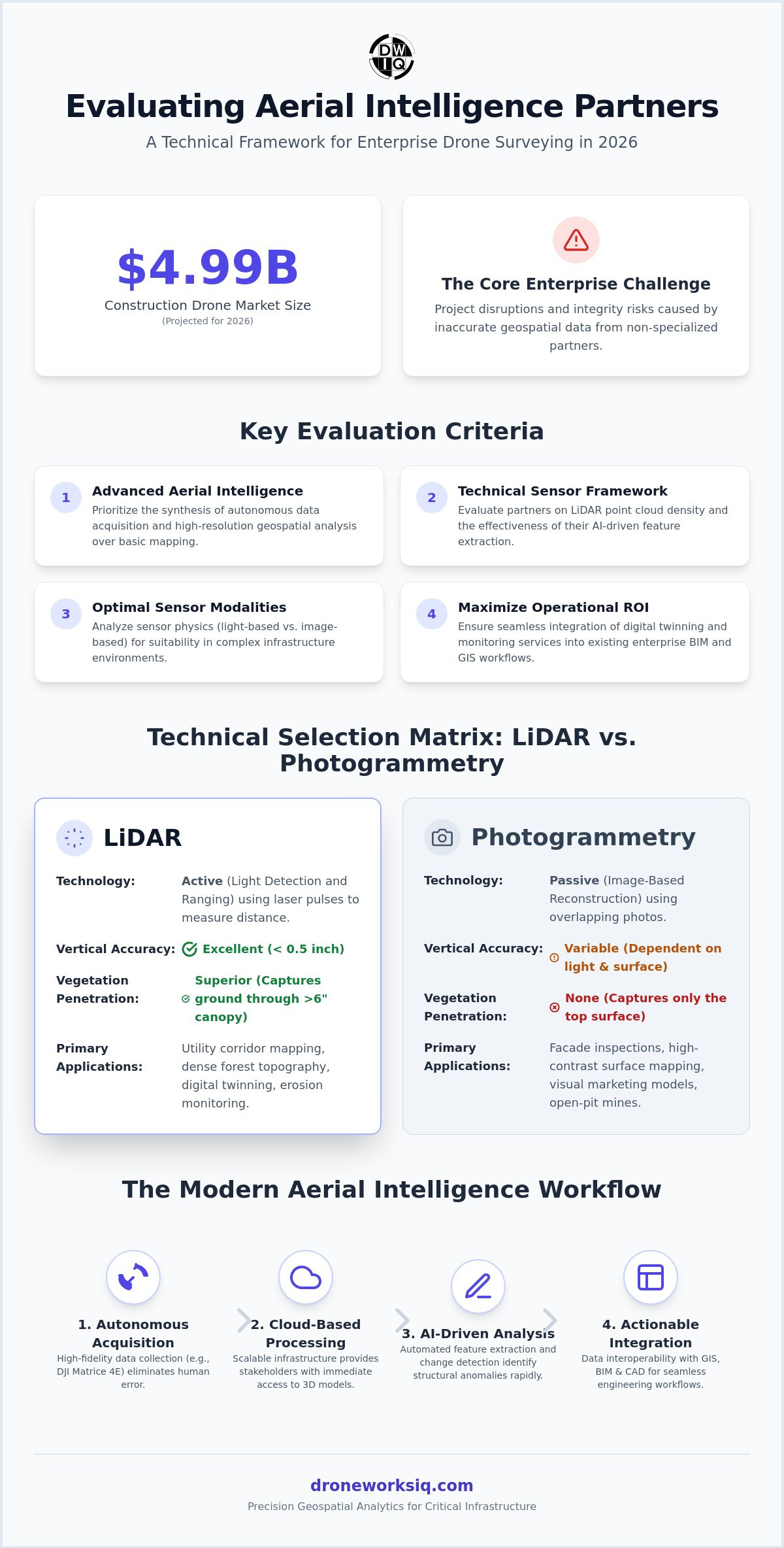
Evaluating Sensor Modalities: LiDAR vs. Photogrammetry
Selecting the appropriate sensor modality is a critical decision that determines the technical viability of a geospatial project. Enterprise drone surveying companies must distinguish between active laser detection and passive image reconstruction to meet specific engineering tolerances. While photogrammetry relies on the triangulation of overlapping visual data, LiDAR utilizes active light pulses to measure distances, providing distinct advantages in environments with complex geometry or obstructed surfaces.
The physics of LiDAR allow for the penetration of dense vegetation to capture precise ground topography, a capability that passive sensors lack. This makes LiDAR the mandatory choice for utility corridor and pipeline inspections where the digital model must account for the "bare earth" beneath 6 inches of canopy cover. A detailed UAV Land Surveying vs Traditional Methodologies analysis confirms that sensor selection directly dictates the fidelity of the final geospatial product and the subsequent accuracy of infrastructure intelligence.
When to Prioritize LiDAR Data Collection
LiDAR is the primary modality for surveying complex vertical assets and high-hazard industrial environments. For structures such as 200-foot facades or cellular towers, the active sensor captures fine structural details and narrow apertures that photogrammetry often obscures. The cost-benefit ratio for large-scale digital twinning projects favors LiDAR when the objective is structural integrity rather than simple visual representation. The high-density point clouds generated by these sensors provide the foundational data required for advanced engineering simulations and predictive maintenance.
The Role of Photogrammetry in Visual Intelligence
Photogrammetry remains a strategic asset for site progress monitoring and high-resolution texture mapping. It excels in providing photorealistic visual intelligence for stakeholders who require intuitive 3D models for project oversight. Leading drone surveying companies often employ a hybrid approach, combining the structural precision of LiDAR with the visual fidelity of photogrammetry. This synthesis results in a comprehensive digital twin that supports both technical analysis and visual communication. To implement these sophisticated data collection strategies, organizations should utilize expert LiDAR data collection and analysis to ensure every mission meets enterprise-grade standards.
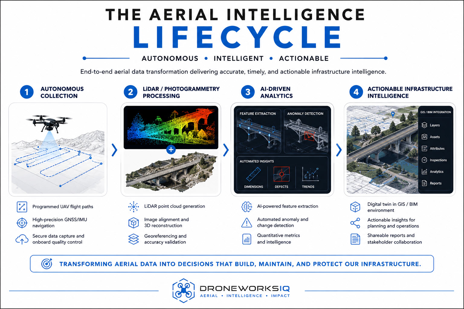
Strategic Implementation: Partnering for Infrastructure Intelligence
Deploying autonomous aerial data collection at scale requires a transition from vendor-based hardware operations to strategic intelligence partnerships. Leading drone surveying companies don't merely capture imagery; they provide the analytical foundation for national infrastructure management. This framework prioritizes the transformation of raw geospatial data into actionable insights, ensuring that high-resolution outputs directly inform long-term asset strategies. By utilizing enterprise geospatial consulting, organizations can significantly reduce asset management costs through more precise intervention and resource allocation. To further support these financial goals through specialized audit and tax planning, discover Davis & Co LLP.
The ROI of AI-driven analytics is most evident in high-frequency monitoring sectors. Erosion monitoring services and agri-health mapping utilize temporal data to identify subtle environmental shifts before they manifest as critical failures. For national infrastructure, this predictive capability ensures that maintenance is proactive rather than reactive. DroneWorksIQ functions as the primary partner for this level of infrastructure intelligence, moving beyond basic flight to deliver comprehensive digital twinning and advanced data analysis.
Operationalizing Data with AI Analytics
Advanced AI feature extraction is the mechanism that identifies structural anomalies during complex facade inspections. These algorithms process high-resolution imagery to detect cracks or moisture ingress with precision that exceeds manual oversight. Predictive modeling for pipeline integrity and utility corridor maintenance leverages these same analytical stacks to forecast structural decay. Organizations seeking to implement these capabilities should evaluate Enterprise Drone Mapping Services to ensure their geospatial workflows are optimized for autonomous analysis and enterprise integration.
Securing the Future of Infrastructure Intelligence
The evaluation of drone surveying companies for 2026 requires a transition from basic operational metrics to a focus on analytical depth and national scalability. Precision remains the primary objective. Technical leaders must prioritize the acquisition of high-fidelity digital twins that serve as a unified source of truth for complex asset management. This methodical approach ensures that geospatial data functions as a dynamic tool for predictive maintenance rather than a static visual record.
DroneWorksIQ provides the specialized LiDAR data collection and AI-driven geospatial analytics necessary for national infrastructure digital twinning. Our clinical focus on technical precision facilitates the transformation of raw data into actionable infrastructure intelligence across diverse geographic locations. By implementing autonomous systems and sophisticated data analysis, we ensure that your geospatial objectives meet the highest engineering standards. Strategic integration of these analytical frameworks ensures long-term operational efficiency and asset longevity.
Consult with DroneWorksIQ for Enterprise Aerial Intelligence
Frequently Asked Questions
How do drone surveying companies ensure data accuracy at scale?
Drone surveying companies maintain centimeter-level accuracy through the rigorous application of Real-Time Kinematic (RTK) and Post-Processed Kinematic (PPK) GPS technologies. These systems ensure spatial integrity by referencing high-precision ground control points across expansive project sites. Standardized sensor calibration protocols and automated quality assurance workflows eliminate manual error, ensuring that geospatial datasets remain consistent during national-level infrastructure deployments.
What is the difference between drone mapping and LiDAR surveying?
Drone mapping typically refers to photogrammetry, which utilizes overlapping high-resolution imagery to reconstruct 3D environments through visual triangulation. In contrast, LiDAR surveying involves active laser pulses that measure distances by recording the time of flight for light to return to the sensor. This active modality allows for the penetration of dense foliage to capture the underlying terrain, a capability essential for utility corridor and pipeline inspections where ground-level precision is mandatory.
How much does it cost to hire an enterprise drone surveying partner?
Project costs for enterprise aerial intelligence are determined by the complexity of the sensor modality, the total geographic area, and the depth of the required geospatial analysis. LiDAR-based surveys generally require a higher investment than standard photogrammetry due to the sophisticated hardware and specialized data processing involved. Strategic partners provide custom quotes based on specific infrastructure requirements, such as the necessity for sub-inch vertical accuracy or AI-driven feature extraction for digital twinning.
Can drone surveying data be integrated into existing BIM or GIS software?
Geospatial data captured by drone surveying companies is designed for seamless integration into existing BIM, GIS, and CAD environments. Deliverables are provided in industry-standard formats, such as LAS for point clouds and GeoTIFF for orthomosaics, ensuring interoperability with platforms like Autodesk Revit or Esri ArcGIS. This compatibility allows technical teams to incorporate high-resolution aerial intelligence directly into structural models and geographic databases without the friction of manual data conversion.
What industries benefit most from autonomous aerial data collection?
Autonomous aerial data collection provides the highest utility for sectors managing large-scale, high-stakes assets, including national infrastructure, energy utilities, and industrial construction. The utility sector utilizes these systems for pipeline and transmission line oversight, while the construction industry employs digital twinning for progress monitoring and erosion control. Agricultural entities also leverage agri-health mapping to optimize crop yields through the analysis of multi-spectral data and autonomous field assessments.
Originally published by DroneWorksIQ. Legacy source.