
INSIGHTS
Enterprise Geospatial Data Consulting: A Strategic Framework for Infrastructure Intelligence
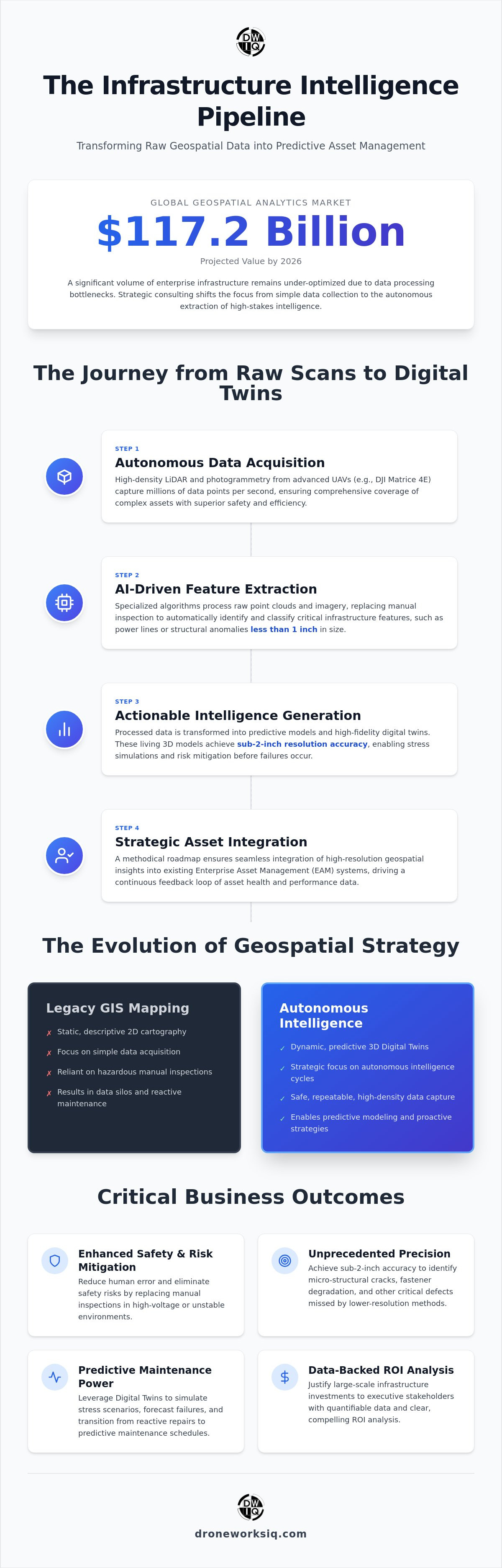
The global geospatial analytics market is projected to reach $117.2 billion by the end of 2026, yet a significant volume of enterprise infrastructure remains under-optimized due to data processing bottlenecks. You're likely managing massive datasets of raw LiDAR and drone imagery that offer little more than visual confirmation of physical assets. Strategic geospatial data consulting addresses this inefficiency by shifting the focus from data collection to the autonomous extraction of high-stakes intelligence. It's a technical necessity for organizations that need to justify the ROI of advanced sensors through measurable industrial outcomes.
This framework outlines the integration of geospatial intelligence into legacy asset management systems to facilitate predictive modeling and risk mitigation. You'll gain a clear understanding of how to transform complex 3D scans into actionable insights that drive infrastructure reliability. We provide a methodical overview of the transition from basic aerial mapping to sophisticated digital twinning for high-resolution oversight across national utility networks.
Key Takeaway: Enterprise geospatial consulting moves beyond simple mapping to provide a strategic framework for autonomous data transformation, allowing organizations to convert raw 3D models into predictive intelligence and high-resolution oversight.
Defining Geospatial Data Consulting in the Era of Autonomous Intelligence
Modern geospatial data consulting represents the expert orchestration of multi-sensor data acquisition, algorithmic processing, and strategic interpretation. While traditional GIS services often focus on static database management and 2D cartography, contemporary consulting integrates autonomous aerial intelligence cycles to provide a continuous feedback loop of asset health. This methodology aligns with the broader definition of Geospatial Intelligence (GEOINT), which leverages imagery and geospatial information to describe, assess, and visually depict physical features on Earth. It's a fundamental shift from simply recording location to managing the lifecycle of physical assets through digital oversight.
Infrastructure intelligence requires a departure from descriptive mapping toward predictive geospatial modeling. For critical asset oversight, sub-2-inch resolution accuracy is non-negotiable. High-precision data is essential for identifying micro-structural anomalies. Lower-resolution data masks critical defects. It fails to capture structural cracks, fastener degradation, or subtle pipeline shifts that precede catastrophic failure. Effective geospatial data consulting bridges the gap between raw point clouds and executive-level decision-making.
Beyond GIS: The Transition to Spatial Strategy
Consulting transforms static spatial records into dynamic infrastructure digital twins. These high-fidelity 3D models serve as living repositories for sensor data, allowing utilities to simulate stress scenarios before they occur. Strategic consulting also provides the technical expertise necessary to navigate rigorous regulatory environments. It ensures that national infrastructure projects maintain compliance through documented, repeatable data capture protocols that meet federal standards.
The Value Proposition of Autonomous Data Integration
Integrating autonomous UAV systems significantly reduces human error and safety risks inherent in manual inspections. Traditional ground-based surveying often requires personnel to access high-voltage areas or unstable terrain. In contrast, LiDAR-equipped drones capture millions of data points per second with superior efficiency. This high-density reality capture ensures comprehensive coverage of complex geometries, such as bridge trusses or transmission towers, that traditional methods frequently overlook. The result is a more reliable dataset that serves as the foundation for predictive maintenance schedules.
The Technical Architecture of AI-Driven Geospatial Analysis
The technical orchestration of an autonomous intelligence cycle begins with high-frequency LiDAR pulse emission and sensor fusion. This pipeline transforms millions of discrete coordinate points into a coherent digital environment. Specialized geospatial data consulting ensures the selection of sensors capable of capturing thin-diameter assets, such as power lines or structural fissures measuring less than 1 inch. Without high-density point clouds, these critical features disappear during decimation or filtering processes. High-fidelity reality capture is the prerequisite for all subsequent analytical layers.
Modern AI-driven geospatial analytics automate the identification of these features, replacing manual inspection with algorithmic precision. While LiDAR provides the geometric foundation, photogrammetry generates the high-fidelity texture maps required for comprehensive facade inspections. This dual-sensor approach aligns with the USGS Data Strategy, which emphasizes a data-centric culture and robust architecture for enterprise innovation. By standardizing these capture methodologies, organizations create a repeatable framework for asset oversight.
LiDAR Point Cloud Processing for Precision Assets
Enterprise-scale LiDAR analysis requires a methodical approach to pulse return intensity and coordinate registration. Raw data pulses must undergo rigorous noise reduction and ground classification before conversion into 3D terrain models. This process is foundational for creating infrastructure digital twins that maintain spatial integrity across thousands of feet of linear assets. Organizations seeking to optimize these workflows often benefit from professional LiDAR data collection and analysis to ensure sub-2-inch accuracy across the entire project footprint.
Automated Feature Extraction and Predictive Modeling
Artificial intelligence models facilitate the rapid detection of structural degradation and environmental shifts. This includes coastal erosion monitoring through volumetric change detection and the identification of vegetation encroachment near utility corridors. In the agricultural sector, agri-health aerial imaging utilizes NDVI mapping to quantify crop stress at a granular level. These automated outputs provide the technical depth required for large-scale industrial management and predictive maintenance, transforming raw spatial data into executive-level intelligence.
Evaluation Criteria for Enterprise Geospatial Consulting Partners
Selecting a partner for geospatial data consulting necessitates a rigorous assessment of technical maturity that extends beyond vendor-specific certifications. Enterprise decision-makers must prioritize technological neutrality. This ensures the consultant selects hardware and software based on specific infrastructure requirements rather than ecosystem lock-in. This objective approach is central to the Spatial Data Infrastructure Roadmap. It advocates for interoperable frameworks that support national-scale data integration and strategic industrial application.
Data security protocols must provide comprehensive protection for sensitive national infrastructure information. Encrypted, cloud-native workflows are mandatory for maintaining data sovereignty. The depth of AI integration determines the reliability of the output. Manual feature extraction introduces unacceptable levels of human error in high-stakes environments. Automated pipelines ensure that anomalies are detected with clinical precision across thousands of miles of utility corridors. Reliability is built on algorithmic consistency, not manual oversight.
Assessing Autonomous Capability and Hardware Maturity
Hardware selection must include advanced LiDAR sensors capable of penetrating dense canopy to reach the ground surface. This capability is a requirement for accurate erosion monitoring and terrain modeling. Autonomous flight paths are essential for high-frequency data collection. They guarantee repeatable sensor positioning. This allows for precise temporal change detection and reliable digital twin updates. Consistent spatial registration is impossible without these automated flight protocols.
Regulatory Compliance and National Scalability
National scalability depends on a partner's ability to navigate complex regulatory landscapes. This includes maintaining strict Part 107 compliance. Securing specialized Federal Aviation Administration (FAA) waivers for Beyond Visual Line of Sight (BVLOS) operations is equally critical. Such authorizations are necessary for the efficient oversight of geographically dispersed assets. For organizations requiring national-scale deployment, selecting a partner with proven utility and pipeline inspection services ensures operational consistency across diverse regulatory jurisdictions.
Strategic Integration: Transforming Raw Data into Executive Intelligence
The transition from raw spatial data to executive intelligence requires a methodical integration roadmap that aligns autonomous outputs with corporate objectives. Professional geospatial data consulting facilitates this by establishing API-driven workflows that ingest processed intelligence directly into existing Enterprise Asset Management (EAM) platforms. This ensures that detected anomalies, such as structural degradation or vegetation encroachment, automatically trigger maintenance protocols within systems like SAP or IBM Maximo. Data without integration is a bottleneck. Integrated intelligence is a strategic asset.
Quantifying the ROI of advanced geospatial technology is a core function of high-level consulting. By shifting from reactive to predictive maintenance models, organizations significantly reduce long-term Operations and Maintenance (O&M) expenditures. DroneWorksIQ bridges the gap between raw aerial capture and board-level strategy by providing the technical depth required to justify large-scale infrastructure investments. Board-level decisions rely on empirical evidence. We provide the high-resolution oversight necessary to validate those decisions through data-backed risk mitigation and asset longevity analysis.
The future of the sector involves a move toward fully autonomous, real-time infrastructure oversight. Static digital twins will evolve into dynamic entities that reflect real-world conditions with minimal latency. This progression allows for a level of operational agility previously unattainable in large-scale industrial environments. As sensor technology and AI algorithms continue to mature, the role of geospatial data consulting will be to manage the increasing complexity of these autonomous intelligence cycles, ensuring that every data point serves a documented strategic purpose.
The Key Takeaway for Infrastructure Executives
Geospatial consulting is the critical link between autonomous hardware and actionable infrastructure intelligence. Effective asset management is built on precision data measured in inches, not feet. Organizations that fail to adopt a structured framework for data transformation will remain overwhelmed by raw volume, while those that integrate these insights will achieve superior reliability and reduced operational risk.
Key Takeaway: Modern infrastructure intelligence depends on the clinical transformation of raw autonomous data into integrated, executive-level insights that drive measurable ROI and predictive asset oversight.
Advancing Infrastructure Resilience through Autonomous Oversight
The transition from manual asset inspection to autonomous intelligence is no longer a peripheral upgrade; it's a structural requirement for modern infrastructure management. Success in this high-stakes environment depends on the clinical orchestration of high-density LiDAR capture and automated feature extraction. Strategic geospatial data consulting provides the necessary framework to convert these complex 3D models into actionable executive intelligence. This methodology ensures every data point contributes to a measurable reduction in operational risk and a quantifiable increase in asset longevity.
By integrating AI-driven analytics with existing enterprise systems, organizations achieve a level of high-resolution oversight that was previously unattainable. It's the difference between descriptive mapping and predictive digital twins that reflect real-world conditions with clinical accuracy. Every decision is backed by sub-2-inch precision, providing a foundation for reliable long-term investment. It's time to optimize your data pipeline and secure your infrastructure's future with precision-engineered solutions.
Partner with DroneWorksIQ for Advanced Geospatial Intelligence to leverage our expertise in advanced LiDAR data collection and analysis. Our autonomous aerial intelligence for national infrastructure provides the technical depth required for sophisticated industrial applications. We deliver the AI-driven geospatial analytics necessary to transform raw data into high-stakes strategic outcomes. Secure your operational future through the deployment of advanced spatial strategy.
Frequently Asked Questions
What is the difference between GIS consulting and geospatial data consulting?
GIS consulting primarily focuses on the management of spatial databases and traditional 2D cartography within established software environments. In contrast, geospatial data consulting provides a comprehensive framework for the end-to-end autonomous intelligence cycle, integrating multi-sensor acquisition with algorithmic interpretation to drive strategic industrial outcomes. It moves beyond simple location recording to manage the entire lifecycle of physical assets through high-fidelity digital twins and predictive modeling.
How does LiDAR technology improve the accuracy of geospatial data?
LiDAR technology enhances accuracy by emitting millions of laser pulses per second to create high-density point clouds with sub-2-inch precision. Unlike passive photogrammetry, LiDAR's active sensing capabilities allow it to penetrate dense vegetation to reach the ground surface and capture thin-diameter features like power lines or structural fissures. This technical depth ensures that micro-anomalies are recorded with clinical accuracy, preventing critical data loss during the decimation or filtering processes.
Can geospatial consulting help with regulatory compliance for national infrastructure?
Specialized consulting ensures that infrastructure projects adhere to rigorous regulatory standards through documented and repeatable data capture protocols that meet federal requirements. This includes navigating complex Federal Aviation Administration (FAA) landscapes such as Part 107 compliance and securing specialized Beyond Visual Line of Sight (BVLOS) waivers. By maintaining these standards, consultants provide the legal and technical verification necessary for the oversight of geographically dispersed national assets.
What industries benefit most from AI-driven geospatial analytics?
Utilities, construction, and large-scale agriculture derive the most significant benefits from AI-driven geospatial analytics due to their reliance on vast, geographically dispersed physical assets. These sectors use automated feature extraction to monitor transmission corridors, track construction progress, and assess crop health through NDVI mapping. Additionally, environmental agencies utilize these analytics for coastal erosion monitoring, leveraging volumetric change detection to predict and mitigate land loss across thousands of feet of shoreline.
How do you measure the ROI of geospatial data consulting services?
ROI is measured through the quantification of reduced Operations and Maintenance (O&M) expenditures and the mitigation of catastrophic failure risks. By transitioning from reactive to predictive maintenance models, organizations extend asset longevity and optimize resource allocation based on empirical data. Geospatial data consulting facilitates this by justifying infrastructure investments through high-resolution oversight and data-backed risk analysis, ultimately lowering the total cost of ownership for complex industrial assets.
Originally published by DroneWorksIQ. Legacy source.