
INSIGHTS
Expert Guide: Best Drone Survey Software for Professionals
In 2025, 37% of FAA enforcement actions against drone operators resulted from deficient record-keeping and data mismanagement. This statistic highlights a critical vulnerability in industrial operations where mission planning fails to account for the complexities of high-precision geospatial requirements. Most enterprise professionals recognize that inconsistent data accuracy across different flight altitudes remains a primary barrier to reliable asset management. This expert guide to drone survey software provides a technical analysis of the architectures necessary to bridge the gap between raw data collection and actionable infrastructure intelligence.
We examine how specific software environments facilitate the seamless transformation of raw imagery into 3D digital twins while maintaining autonomous mission repeatability for long-term erosion monitoring. This analysis focuses on platforms that prioritize high-precision outputs with minimal AGL error, ensuring that aerial data integrates directly into existing GIS and asset management systems. You'll learn which processing engines provide the necessary data integrity for enterprise-level LiDAR and AI analytics, effectively eliminating the high re-flight rates that plague substandard mission planning.
Key Takeaways
Identify the architectural shift toward autonomous mission execution frameworks that utilize RTK and PPK integration to maintain geospatial precision within 6 in.
Utilize this expert guide to drone survey software to calibrate terrain-following parameters that ensure consistent ground sample distance and point cloud density across complex topographies.
Differentiate between photogrammetric and laser-based software configurations to optimize sensor triggering for specialized industrial applications such as facade structural analysis.
Analyze the transition from 3D point clouds to AI-driven geospatial analytics for automated feature extraction and the development of predictive digital twins.
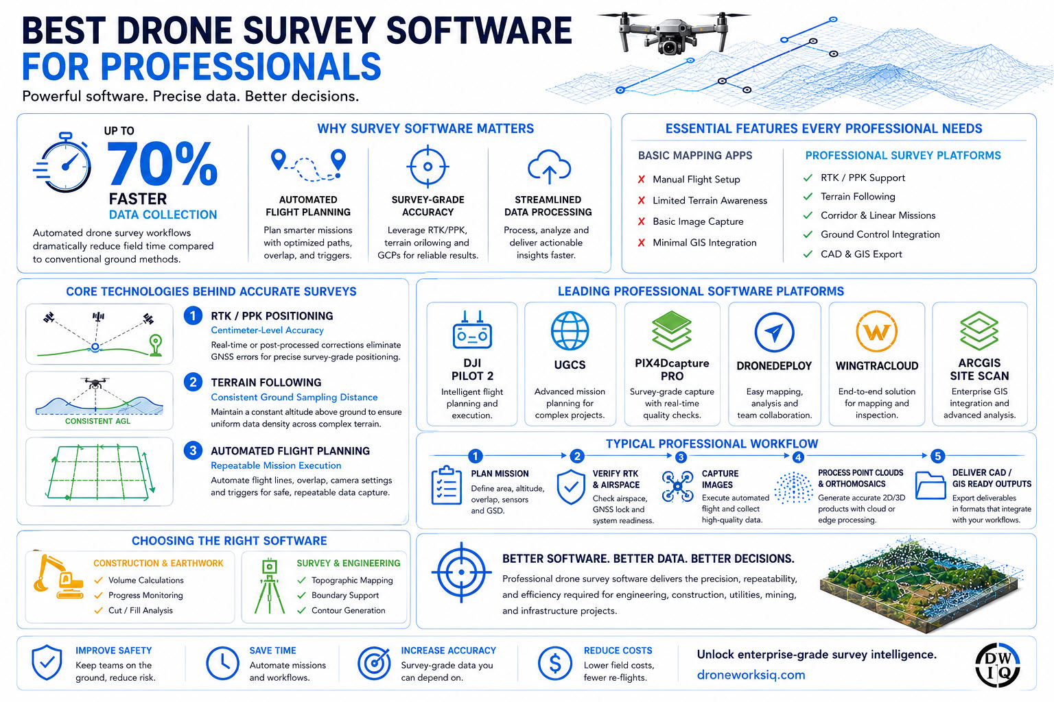
Technical Foundations of Autonomous Survey Software
Modern geospatial intelligence relies on the transition from pilot-centric manual operation to software-defined autonomous execution frameworks. This architectural shift eliminates human-induced variance during data acquisition, ensuring that every flight produces a standardized dataset. By utilizing an unmanned aerial photogrammetric survey methodology, professionals ensure that flight paths are mathematically optimized for specific sensor requirements. This expert guide to drone survey software emphasizes that autonomy is the prerequisite for generating high-fidelity digital twins that meet industrial standards.
Achieving sub-6 in absolute accuracy requires the rigorous integration of Real-Time Kinematic (RTK) or Post-Processed Kinematic (PPK) workflows within the flight control software. These systems correct GNSS positioning errors in real-time or through post-flight telemetry synchronization. Software architectures that lack deep RTK integration often suffer from vertical drift, which compromises the reliability of volumetric calculations and topographic contours. Professional-grade platforms automate the alignment of image metadata with high-precision timestamps, reducing the reliance on manual ground control points.
Processing large-scale geospatial datasets necessitates a strategic choice between cloud-based scalability and edge-processing security. Cloud architectures allow for distributed computing power, a necessity for rapid orthomosaic generation across thousands of acres. Conversely, edge-processing provides localized control for sensitive infrastructure data, keeping analysis within secure corporate firewalls. Standardizing outputs into universal formats like LAS, LAZ, or GeoTIFF ensures that raw aerial data converts into actionable infrastructure intelligence without compatibility bottlenecks in existing GIS environments.
Key Takeaway: The Primacy of Data Integrity
Data integrity represents the absolute fidelity of captured geospatial coordinates relative to their terrestrial counterparts, serving as the foundational requirement for autonomous infrastructure oversight. Software-driven precision dictates the return on investment for aerial programs because inaccurate data necessitates expensive re-flights and leads to flawed engineering decisions during asset management cycles.
Infographic: The Autonomous Survey Workflow
The lifecycle of a professional survey begins with mission parameter definition, where software establishes flight altitude and sensor trigger intervals. This process moves into autonomous execution, where the drone interacts with LiDAR sensors to capture raw point clouds with precise geospatial tagging. Finally, the software manages the transition from raw data to AI-driven feature extraction, feeding refined intelligence directly into GIS databases for enterprise-level analysis and predictive maintenance.
Mission Planning Parameters for High-Precision LiDAR Capture
Enterprise survey software functions as the operational control center for high-precision data acquisition, moving beyond basic flight navigation into complex sensor orchestration. These specialized suites provide granular command over UAV flight paths and sensor triggers to maintain a consistent Ground Sample Distance (GSD). This level of control is essential for professional LiDAR data collection and analysis, where pulse density must remain uniform across the entire survey area. Integration with industrial platforms like ArcGIS Flight allows operators to synchronize mission parameters with broader GIS databases, ensuring that data collection aligns with enterprise infrastructure requirements. This expert guide to drone survey software notes that mission success depends on the software's ability to manage overlap and side-lap parameters to minimize occlusions in intricate 3D environments.
Precision Metrics: AGL Error and RTK Stability
Maintaining an AGL error within 6 in is mandatory for high-fidelity LiDAR scans. High-precision software monitors RTK fix ratios in real-time; a transition from a fix to a float solution can introduce significant inaccuracies that compromise the integrity of digital twin generation. RTK stability remains a non-negotiable metric for enterprise-grade mission planning, as it ensures the spatial reliability of the resulting point clouds.
Terrain Following for Complex Topographies
Effective terrain following requires the software to ingest existing Digital Elevation Models (DEMs) to adjust flight altitude dynamically. This capability is vital when surveying regions with elevation changes exceeding 400 ft. This expert guide to drone survey software emphasizes that real-time altitude adjustments maintain a constant AGL, preventing point cloud density degradation. For large-scale utility corridor inspections, advanced battery-swap logic and mission resume protocols are required. The software must autonomously track the drone's telemetry, allowing for a seamless restart after power replenishment without creating data gaps or redundant coverage.
Scenario-Specific Software Configurations for Industrial Assets
Operational efficiency in industrial surveying necessitates a binary distinction between photogrammetric and laser-based software configurations. Photogrammetry requires dense overlap parameters, often exceeding 80% for both frontal and side-lap, to facilitate pixel-matching algorithms. Conversely, LiDAR processing focuses on scan frequency and laser return strength. For a technical breakdown of hardware-software synergy, consult this in-depth guide to LiDAR drones. This expert guide to drone survey software highlights that while photogrammetry excels in visual reconstruction, LiDAR's ability to penetrate vegetation makes it the superior choice for topographic analysis in overgrown pipeline corridors.
Linear Asset Planning for Pipelines and Utilities
Managing linear infrastructure spanning several miles requires corridor mapping software capable of handling non-linear flight paths with automated heading adjustments. Signal interference in remote environments necessitates the configuration of intelligent emergency Return to Home (RTH) triggers. These protocols ensure the UAV follows a safe, pre-calculated path back to the launch point if telemetry loss occurs. Our specialized utility and pipeline inspection services leverage these advanced configurations to maintain data continuity across national utility networks.
Vertical Inspection Protocols for Building Facades
Vertical inspections demand software capable of maintaining a precise 20 ft offset from the structure's surface during vertical ascent. Unlike nadir mapping, facade inspection protocols utilize automated image capture triggers based on vertical distance intervals rather than GPS timing. This ensures 100% coverage of structural elements for high-resolution defect detection. For complex construction environments, volumetric analysis configurations allow for automated stockpile measurement and progress monitoring, converting raw point clouds into precise cubic yardage reports for resource management.
From Raw Data to Infrastructure Intelligence: AI Integration
The final phase of the geospatial workflow involves the conversion of high-density point clouds into actionable intelligence. This expert guide to drone survey software recognizes that raw data, while precise, requires sophisticated algorithmic processing to provide strategic value. Professional software environments now integrate neural networks to automate feature extraction. This significantly reduces manual analysis time for large-scale infrastructure projects. Integrating these outputs with enterprise GIS systems enables a unified view of organizational assets across national networks.
Integrating AI-Driven Geospatial Analytics
AI-driven geospatial analytics transforms raw pixels into structured data by identifying patterns that escape human observation. In pipeline and utility inspections, automated defect identification algorithms scan thousands of images to locate structural anomalies or thermal variances. This systematic approach ensures comprehensive oversight of national infrastructure networks without the cognitive fatigue associated with manual review. It replaces subjective human assessment with repeatable, data-driven results.
Developing Digital Twins for Asset Management
Creating high-fidelity 3D models requires software capable of exporting process-ready data into specialized engineering environments. These digital twins serve as the foundation for predictive asset management and erosion monitoring. They facilitate virtual inspections, reducing the need for hazardous physical site visits. For large-scale operations, drone-based methodologies can be 50% to 75% less expensive than traditional ground-based survey methods. By maintaining a temporal record of an asset, professionals can simulate environmental impacts and plan maintenance cycles with precision. While AI provides the initial classification, professional geospatial consulting remains essential for interpreting complex inspection reports to ensure effective strategic industrial application.
Optimizing Infrastructure Intelligence Through Advanced Software Integration
The implementation of high-precision geospatial workflows marks a definitive shift from visual observation to structured, AI-enhanced intelligence. This expert guide to drone survey software has established the technical parameters for achieving sub-6 in accuracy through autonomous mission execution and rigorous RTK stability. We've analyzed how specialized configurations for linear assets and building facades mitigate the data inconsistencies inherent in non-autonomous operations. The evolution from raw point clouds to predictive digital twins is now the industry standard for strategic asset management.
DroneWorksIQ offers the sophisticated technical oversight required to manage these high-stakes data environments. We provide national coverage for complex infrastructure inspections, specializing in precision LiDAR data collection and AI analytics. Our strategic geospatial consulting ensures that aerial intelligence translates directly into enterprise-level operational efficiency. Consult with DroneWorksIQ for Enterprise Aerial Intelligence Solutions to secure the precision and data integrity your infrastructure demands.
Frequently Asked Questions
Is drone survey software compatible with all LiDAR sensors?
Compatibility depends on the software's capacity to ingest proprietary raw data formats or standardized LAS or LAZ files. While post-processing suites often support universal formats, mission planning software requires specific drivers for real-time sensor triggering and telemetry synchronization. Professional deployments necessitate verifying that the flight controller communicates directly with the LiDAR's internal inertial measurement unit. This ensures precise geospatial tagging during the acquisition phase of the survey.
How does RTK integration improve the accuracy of a drone survey?
RTK integration provides centimeter-level positioning by correcting GNSS errors in real-time through a base station or NTRIP network. This expert guide to drone survey software emphasizes that such integration reduces absolute horizontal and vertical error to within 2 in. By eliminating the reliance on numerous manual ground control points, RTK streamlines field workflows while ensuring the spatial integrity of 3D digital twins. It's the primary method for achieving industrial-grade precision.
Can drone survey software automate building facade inspections?
Specialized software suites automate facade inspections by executing vertical flight paths with a constant structural offset, often maintained at 20 ft. These autonomous frameworks trigger high-resolution image capture based on precise vertical distance intervals rather than GPS timing. This methodology ensures 100% coverage of the structural surface. It's essential for identifying minute defects like hairline cracks or corrosion in complex infrastructure environments where manual flight is too inconsistent.
What is the difference between mission planning software and data processing software?
Mission planning software controls the UAV’s flight path and sensor orchestration during acquisition, while data processing software converts raw inputs into geospatial outputs. Planning tools manage terrain following and battery-swap logic; processing engines utilize photogrammetry or LiDAR algorithms to generate point clouds. Both stages are critical in an expert guide to drone survey software. They function as the dual nodes of an autonomous infrastructure intelligence ecosystem.
How does terrain following prevent data gaps in hilly environments?
Terrain following utilizes onboard sensors or pre-loaded Digital Elevation Models to adjust the drone's altitude dynamically relative to the topography. By maintaining a constant Above Ground Level height, the software ensures a uniform Ground Sample Distance and consistent LiDAR point density. This prevents the data resolution degradation that occurs when a drone flies too high over depressions. It's a mandatory configuration for surveying hilly environments without creating significant data gaps.
Originally published by DroneWorksIQ. Legacy source.