
INSIGHTS
Expert Guide to Drone Mapping Software: Key Solutions
Surface-level photogrammetry remains insufficient for industrial-scale infrastructure analysis where a single inch of variance determines project viability. Technical decision-makers often struggle with the fragmentation between aerial data acquisition and downstream engineering workflows. This lack of cohesion frequently results in data silos and prohibitive internal management costs that undermine the efficiency of high-stakes geospatial projects.
Establishing a definitive guide to drone mapping software requires a shift from qualitative assessment to a rigorous evaluation of processing engine consistency and geospatial integrity. You've likely observed that while hardware capabilities have stabilized, the software layer remains the primary source of technical friction. This analysis provides an authoritative framework for selecting solutions that facilitate sub-inch accuracy and the seamless integration of aerial datasets into enterprise digital twins. We'll examine the deployment of autonomous systems and AI-powered feature extraction to ensure your geospatial strategy achieves maximum industrial precision and strategic oversight.
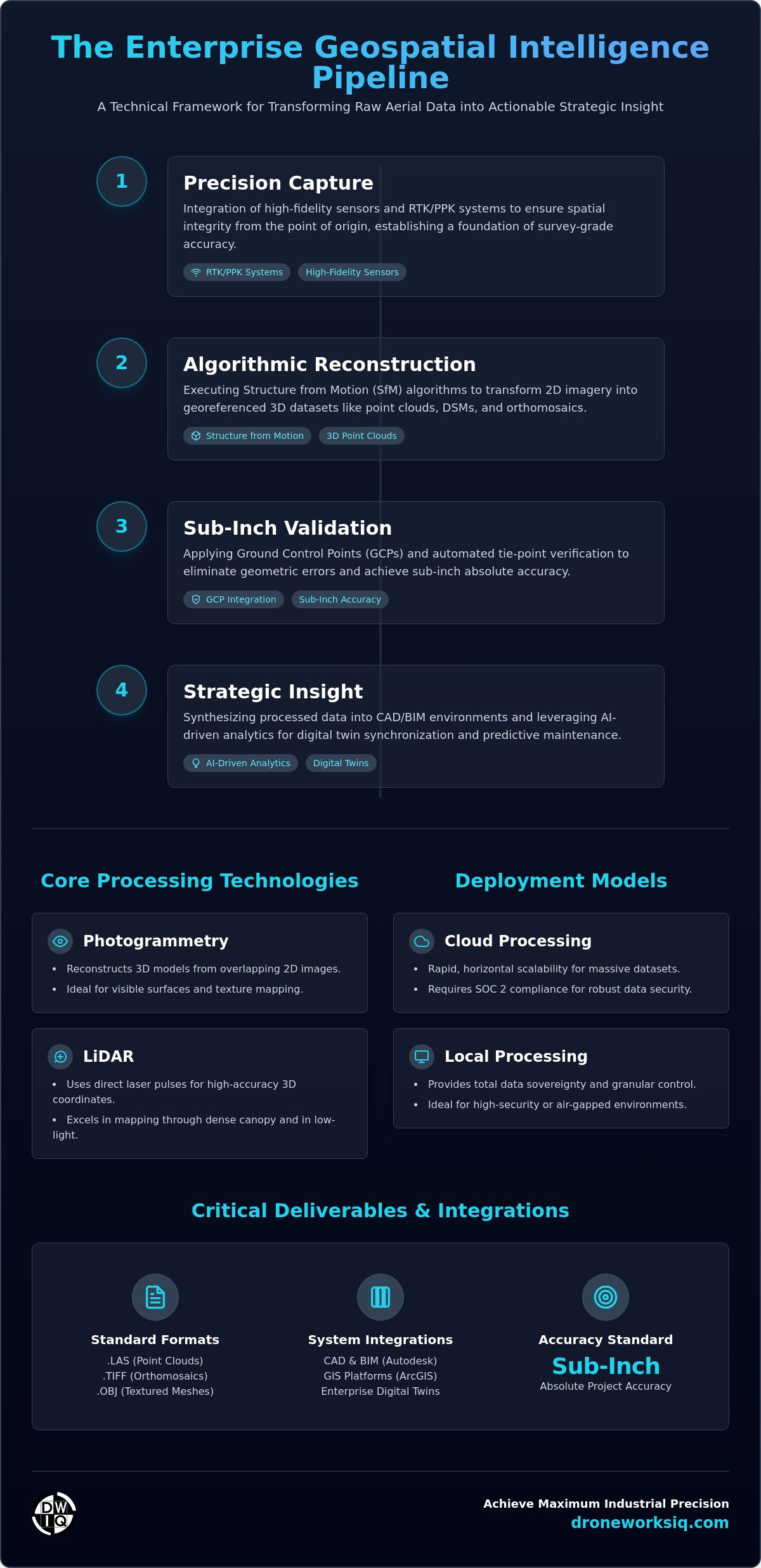
Infographic: The Enterprise Geospatial Intelligence Pipeline
This visual framework delineates the technical progression from raw data acquisition to strategic asset oversight. The workflow encompasses four critical phases:
Precision Capture: Integration of high-fidelity sensors and RTK/PPK systems to ensure spatial integrity from the point of origin.
Algorithmic Reconstruction: Execution of Structure from Motion (SfM) processes to transform 2D imagery into georeferenced 3D datasets.
Sub-Inch Validation: Application of Ground Control Points (GCPs) and automated tie-point verification to eliminate residual geometric errors.
Strategic Insight: Synthesis of processed data into CAD/BIM environments and AI-driven analytics for predictive infrastructure maintenance.
Understanding Drone Mapping Software Architecture
Drone mapping software functions as the sophisticated algorithmic engine required to synthesize raw aerial imagery and disparate sensor metadata into actionable, georeferenced deliverables. It's not merely a visualization tool; it's a high-performance computational framework that executes complex photogrammetric reconstructions. This process relies on Structure from Motion (SfM) algorithms to identify conjugate points across overlapping images, ultimately generating high-density point clouds, digital surface models (DSMs), and orthomosaics. For organizations seeking a comprehensive guide to drone mapping software, understanding this architectural foundation is critical for ensuring survey-grade outputs.
Precision depends on the software's ability to ingest and process high-fidelity spatial data from Real-Time Kinematic (RTK) and Post-Processed Kinematic (PPK) systems. Without native support for these high-precision GNSS workflows, the resulting models lack the centimeter-level absolute accuracy required for engineering-grade applications. Professional platforms must also facilitate seamless data interoperability. This requires robust export capabilities for industry-standard formats, including .LAS for point clouds, .TIFF for rasterized orthomosaics, and .OBJ for textured mesh models. These formats ensure direct integration into Computer-Aided Design (CAD) and Building Information Modeling (BIM) environments. Open-source initiatives like OpenDroneMap have further expanded the accessibility of these processing pipelines, providing transparent methodologies for technical users.
Photogrammetry vs. LiDAR Data Processing
While photogrammetry reconstructs geometry from 2D images, LiDAR processing utilizes direct laser-pulse measurements to generate discrete 3D coordinates. LiDAR software is indispensable for mapping terrain through dense canopy or within low-light industrial corridors where passive sensors fail. The processing overhead for LiDAR is significant. Systems must manage millions of discrete returns per second, necessitating specialized filtering algorithms to separate ground points from non-ground noise. This differs from the pixel-matching overhead inherent in standard RGB photogrammetric workflows, placing higher demands on local or cloud-based computational resources. Accurate LiDAR analysis ensures that infrastructure intelligence remains reliable even in complex environments where traditional imagery is insufficient.
Strategic Criteria for Evaluating Enterprise Geospatial Platforms
A rigorous guide to drone mapping software prioritizes the elimination of data artifacts through advanced algorithmic validation. Absolute accuracy remains the primary metric, demanding platforms that facilitate the ingestion of Ground Control Points (GCPs) and the execution of automated tie-point generation with minimal residual error. This technical foundation ensures that digital twins reflect real-world conditions with sub-inch precision. Modern enterprise solutions must also facilitate the synthesis of diverse sensor payloads, incorporating thermal and multispectral data alongside research in advanced UAV remote sensing to drive automated feature detection. This technical synergy allows distributed engineering teams to annotate and measure digital twins in real-time, accelerating critical decision-making cycles.
Cloud vs. Local Processing: An Enterprise Comparison
Cloud-based processing architectures provide rapid horizontal scalability, allowing for the simultaneous reconstruction of massive datasets across distributed server clusters. Conversely, desktop processing offers the granular control and total data sovereignty required for high-security, air-gapped industrial environments. Enterprise-grade platforms must demonstrate SOC 2 compliance to mitigate the cybersecurity risks associated with the storage and transmission of sensitive infrastructure intelligence. Choosing between these models depends on the specific balance of processing speed versus internal security protocols.
Critical Integrations for Infrastructure Workflows
Seamless data interoperability with GIS platforms like ArcGIS and BIM environments such as Autodesk Revit is a technical necessity for modern engineering workflows. Mapping software must execute precise coordinate system transformations to maintain geometric alignment with established project datums and local state plane coordinates. Professional Drone Mapping and Photogrammetry Services ensure these transformations are handled with the mathematical rigor required for multi-year infrastructure projects, preventing the spatial drift that often plagues amateur-led data collection. This level of integration transforms raw imagery into a functional component of the broader enterprise data ecosystem.
Industrial Applications: Transforming Imagery into Infrastructure Intel
The transition from raw data acquisition to actionable intelligence occurs when specialized software layers are applied to specific industrial challenges. High-performance mapping platforms facilitate Construction Intel by providing sub-inch volumetric measurements for stockpile management and automated site progress tracking. This spatial oversight allows project managers to identify deviations from design plans before they escalate into costly structural corrections. In the energy sector, software optimized for utility and pipeline inspection enables the detection of minute structural anomalies across hundreds of miles of remote infrastructure, significantly reducing the reliance on manual ground patrols.
Vertical infrastructure requires even higher levels of resolution. Facade inspection protocols utilize high-fidelity 3D models to identify hairline fractures or thermal leaks on structures at heights exceeding 200 ft. This level of detail is impossible to achieve with traditional scaffolding or rope access methods. For environmental management, this guide to drone mapping software emphasizes the importance of temporal analysis in erosion monitoring. By comparing historical datasets, engineers can quantify soil displacement along coastal or riparian corridors with methodical accuracy. Organizations requiring these high-precision outputs should leverage professional Construction Intel services to ensure data integrity across the project lifecycle.
Digital Twinning for Asset Management
A digital twin serves as a high-fidelity 3D replica of physical infrastructure that evolves synchronously with real-world sensor data. Mapping software facilitates predictive maintenance by enabling automated comparisons between historical and current 3D models. This temporal oversight allows for the identification of structural fatigue or deformation over time, transforming a static map into a dynamic asset management tool that informs long-term capital expenditure strategies.
Agri-Health and Environmental Mapping
Advanced geospatial platforms utilize multispectral indices, such as the Normalized Difference Vegetation Index (NDVI), to conduct large-scale agricultural health assessments. This technical approach identifies crop stress or nutrient deficiencies before they become visible to the naked eye. In industrial contexts, these indices are critical for vegetation management within utility corridors, ensuring that growth does not interfere with high-voltage transmission lines or pipeline access roads.
The Evolution from Data Processing to Strategic Geospatial Consulting
Software applications have reached a state of commoditization where the possession of a processing engine no longer provides a technical advantage. This guide to drone mapping software demonstrates that the strategic value lies in the rigorous interpretation of synthesized data. Raw spatial outputs lack utility without a methodical framework for transforming them into infrastructure intelligence. Organizations must bridge this gap by integrating AI-driven geospatial analytics to extract high-level insights from complex datasets.
Integrating AI for Automated Feature Extraction
Professional Oversight in Data Validation
Algorithmic detection requires human expert validation to maintain survey-grade reliability. Automated systems can generate false positives or overlook subtle geometric anomalies that a technical consultant will identify. Professional oversight mitigates the operational risks inherent in high-stakes infrastructure projects where data errors lead to catastrophic structural failures. This human-in-the-loop approach ensures that the final deliverables meet the precision standards required for engineering-grade applications.
The financial burden of internal software management often exceeds the cost of professional procurement. Maintaining an internal stack involves significant overhead, including pilot training, high-performance hardware, and continuous license fees. Selecting a partner that understands the full guide to drone mapping software ecosystem ensures superior ROI. DroneWorksIQ operates as a strategic partner, managing the entire lifecycle from initial aerial capture to the delivery of verified, actionable insights.
Just as technical precision is vital for geospatial data, strategic precision in digital outreach is essential for firms in this sector to grow; services like toptarget.hu help high-tech businesses maximize their market impact through data-driven campaigns.
Advancing Enterprise Infrastructure Intelligence
Achieving centimeter-level accuracy across industrial environments requires more than simple software procurement; it demands the rigorous integration of high-precision data capture and advanced algorithmic processing. This guide to drone mapping software has established that the primary value of geospatial platforms lies in their ability to transform raw sensor data into actionable infrastructure intelligence. By prioritizing specialized LiDAR data collection and AI-driven geospatial analytics, technical decision-makers can eliminate data silos and ensure long-term asset integrity.
Strategic oversight involves moving beyond the commoditized software layer to focus on the expert interpretation of digital twins. Maintaining this level of precision across national infrastructure projects necessitates a partner capable of managing the entire data lifecycle with methodical accuracy. Request a Professional Geospatial Consultation with DroneWorksIQ to align your operational workflows with the highest standards of geospatial science. Your path to comprehensive infrastructure oversight begins with data-driven precision.
Frequently Asked Questions
What is the most accurate drone mapping software for construction sites?
Accuracy depends on the software's capability to integrate high-precision GNSS metadata with Ground Control Points (GCPs). Professional grade platforms facilitate the algorithmic validation of tie-points to ensure centimeter-level absolute precision across large-scale construction sites. This guide to drone mapping software emphasizes that true survey-grade results are achieved through the synergy of RTK-enabled hardware and rigorous processing engines capable of minimizing residual errors.
Can drone mapping software process LiDAR data and photogrammetry simultaneously?
Advanced geospatial platforms facilitate the concurrent processing of LiDAR and photogrammetry datasets to create hybrid digital twins. This synthesis allows the geometric precision of laser scanning to be overlaid with high-resolution visual textures from RGB imagery. It's a critical capability for complex infrastructure inspections where both structural geometry and surface condition must be analyzed synchronously within a single georeferenced environment.
Do I need a specialized computer to run drone mapping software locally?
Local processing necessitates high-performance workstations equipped with multi-core CPUs, significant RAM, and dedicated GPUs for hardware acceleration. Desktop-based solutions offer superior data sovereignty for sensitive projects but require an upfront investment in hardware typically ranging from $2,000 to $4,000. Cloud-based alternatives mitigate these hardware requirements by offloading computational tasks to distributed server clusters, providing horizontal scalability for massive datasets.
How does drone mapping software integrate with existing GIS and CAD platforms?
Integration occurs through standardized export protocols including .LAS, .TIFF, and .OBJ formats. These files allow for direct ingestion into GIS platforms like ArcGIS and BIM environments such as Autodesk Revit. Efficient software must handle coordinate transformations automatically to ensure that aerial datasets align perfectly with existing project datums and site-specific survey coordinates, preventing spatial drift in multi-year infrastructure projects.
What is the difference between an orthomosaic map and a 3D point cloud?
An orthomosaic is a georeferenced, 2D map composed of stitched aerial images that have been geometrically corrected for perspective and lens distortion. A 3D point cloud is a collection of millions of discrete data points in a three-dimensional coordinate system, representing the external surface of an object or terrain. While the orthomosaic provides a planimetric view for distance measurements, the point cloud facilitates volumetric analysis and detailed structural modeling.
Originally published by DroneWorksIQ. Legacy source.