
INSIGHTS
How to Integrate Drone Data for Asset Management: An Enterprise Framework
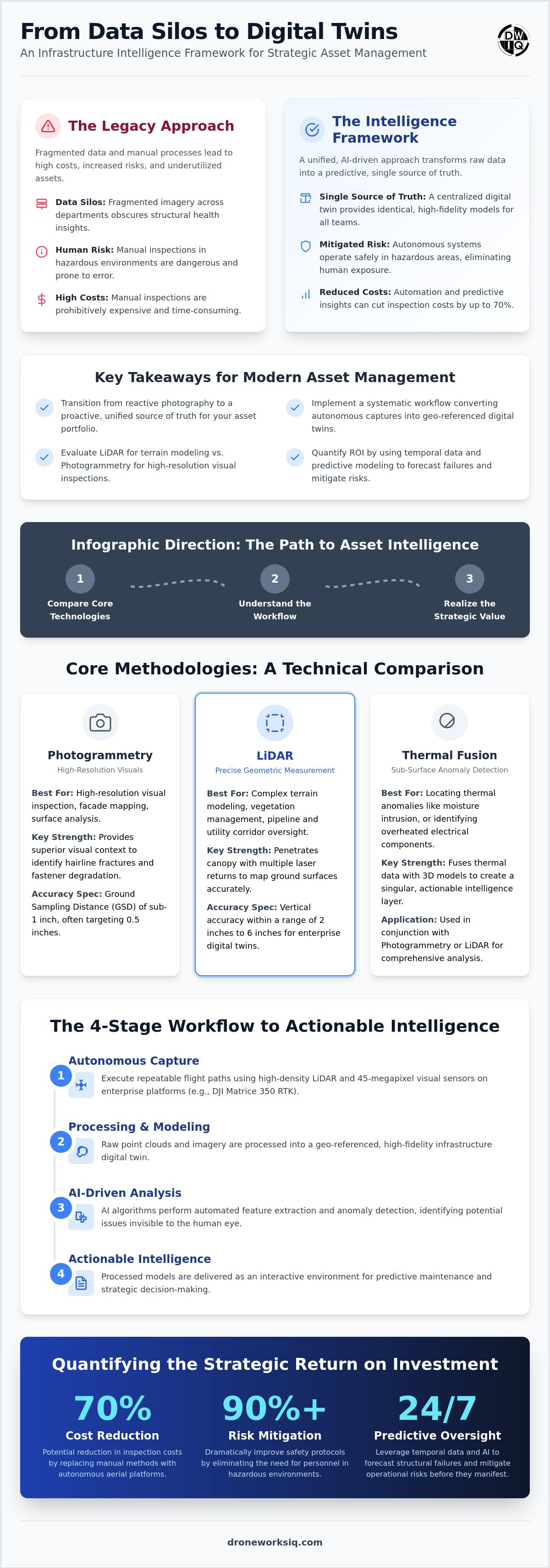
Research indicates that utilizing aerial platforms for infrastructure oversight can reduce inspection costs by up to 70%, yet many enterprises struggle to move beyond simple visual documentation. The accumulation of fragmented imagery across disparate departments often results in data silos that obscure rather than clarify structural health. Without a structured methodology, drone data for asset management remains an underutilized resource that fails to provide the high-level oversight required for complex, large-scale portfolios.
You likely recognize that manual structural inspections are becoming prohibitively expensive and inherently limited by human error. This guide provides a comprehensive framework for converting raw aerial captures into sophisticated infrastructure intelligence through a multi-modal, AI-driven geospatial approach. We will detail the technical transition from manual data silos to a unified digital twin environment, establishing a single source of truth that secures strategic ROI and reduces operational risk through predictive monitoring protocols.
Establishing the Infrastructure Intelligence Framework
Transitioning from simple visual documentation to a robust intelligence framework requires a fundamental shift in operational philosophy. Traditional aerial photography provides static snapshots; however, infrastructure intelligence demands a dynamic, multi-dimensional dataset. By integrating drone data for asset management, enterprises move beyond reactive maintenance into a regime of proactive oversight. This transition is predicated on the deployment of sophisticated sensor arrays capable of capturing high-resolution imagery, LiDAR point clouds, and thermal datasets simultaneously.
Large-scale enterprise asset management necessitates a "single source of truth" to eliminate the data fragmentation common in legacy inspection workflows. Centralizing geospatial data ensures that engineering, maintenance, and executive teams operate from identical, high-fidelity models. Beyond data integrity, autonomous aerial collection significantly mitigates human risk. Deploying unmanned systems into hazardous environments, such as high-voltage utility corridors or unstable industrial facades, eliminates the need for manual climbing or scaffolding. Industry data indicates that these methodologies can reduce overall inspection costs by 30% to 70% while drastically improving safety protocols. Leveraging drone data for asset management provides the comprehensive oversight required to manage risk across vast infrastructure portfolios. This principle of maintaining a secure "single source of truth" for vital data is equally important for personal records, where IronClad Family offers a specialized digital vault to protect and manage critical family and financial assets.
The Role of Autonomous Systems in Data Continuity
Systematic data acquisition relies on the precise replication of flight parameters over extended durations. Autonomous systems facilitate repeatable flight paths, enabling the temporal analysis required to monitor structural degradation or erosion over months and years. This nominalization of data capture ensures that every geospatial output adheres to standardized technical specifications, regardless of the individual operator. Photogrammetry and LiDAR processing benefit from this consistency, allowing for the seamless alignment of historical and current datasets. Autonomous data continuity is the persistent, standardized acquisition of geospatial information that serves as the foundational layer for high-fidelity digital twinning.
Selecting Methodologies: LiDAR vs. Photogrammetry vs. Thermal
Sensor modality selection constitutes the primary technical challenge in establishing a functional intelligence framework. Enterprise-grade drone data for asset management necessitates rigorous adherence to specific accuracy thresholds, typically defined by the Ground Sampling Distance (GSD). For high-fidelity visual inspections and facade mapping, a GSD of sub-1 inch, frequently targeting 0.5 inches, is required to identify hairline fractures or structural fastener degradation. While photogrammetry provides superior visual context for surface analysis, LiDAR offers the geometric precision necessary for complex terrain modeling and vegetation encroachment analysis.
LiDAR Precision and Point Cloud Density
LiDAR systems facilitate precise data acquisition in environments characterized by dense vegetation or intricate vertical geometries. By utilizing multiple laser returns, these sensors penetrate canopy layers to map the ground surface beneath, a critical requirement for pipeline and utility corridor oversight. High-density point clouds must maintain a vertical accuracy within a range of 2 inches to 6 inches to meet enterprise digital twin standards. This level of precision ensures that clearance measurements for high-voltage lines or terrain stability assessments remain within established engineering tolerances.
Multi-Sensor Fusion for Complex Assets
Sophisticated asset oversight requires the integration of concurrent data streams through multi-sensor fusion. Overlaying thermal datasets onto a 3D photogrammetric model allows for the precise localization of thermal anomalies, such as moisture intrusion in roofing systems or overheated components in electrical substations. Utilizing aerial 3D modeling services facilitates this integration, providing a comprehensive visual and analytical environment that enhances decision-making. This approach transforms disparate sensor outputs into a singular, actionable intelligence layer, optimizing the application of drone data for asset management across large-scale infrastructure portfolios.
Step-by-Step: Converting Raw Data into Asset Intelligence
The transformation of raw sensor outputs into actionable intelligence follows a rigorous four-stage technical sequence. This methodology ensures that drone data for asset management transitions from disconnected imagery into a structured geospatial record. The process begins with the execution of autonomous capture protocols using high-density LiDAR and 45-megapixel visual sensors. Following capture, raw point clouds and imagery are processed into a geo-referenced infrastructure digital twin. This high-fidelity model serves as the primary analytical environment. In the third stage, AI-driven algorithms perform automated feature extraction and anomaly detection. Finally, the processed models are integrated into existing Enterprise Resource Planning (ERP) or Geographic Information Systems (GIS) to facilitate cross-departmental oversight.
AI-Driven Feature Extraction and Analysis
Automated detection systems significantly accelerate the identification of structural vulnerabilities. By utilizing AI-driven geospatial analytics, enterprises can achieve over 95% accuracy in detecting corrosion, fastener failure, or structural stress. This automation reduces manual review time by hundreds of man-hours; it allows engineering teams to focus exclusively on high-priority remediation. The system categorizes anomalies based on severity, providing a prioritized list of maintenance requirements within the geospatial environment. It's a fundamental shift from manual photo review to automated intelligence.
Structuring Data for Digital Twin Integration
The transition from a digital twin construction site to a long-term asset management model requires strict adherence to geospatial registration standards. Diverse datasets, including LiDAR and photogrammetry, must be aligned with sub-inch accuracy to maintain the integrity of the temporal record. This precision allows for the comparison of current asset health against baseline conditions, facilitating predictive maintenance strategies. Structured data environments ensure that every asset component is uniquely identified and tracked throughout its operational lifecycle. Accuracy isn't optional for enterprise-grade twinning.
Enterprises seeking to implement these advanced workflows can leverage our specialized digital twinning services to ensure technical accuracy and strategic data integration.
Strategic ROI and Lifecycle Maintenance Oversight
Quantifying the Return on Investment (ROI) for autonomous data collection involves analyzing direct expenditure reductions and long-term risk mitigation. Enterprises utilizing drone data for asset management report overall inspection cost reductions between 30% and 70% compared to traditional manual methods. These fiscal advantages result from the elimination of specialized access equipment, reduced onsite labor hours, and the potential for insurance premium mitigation through documented proactive oversight. Beyond immediate operational savings, the strategic value lies in the substantial reduction of unplanned downtime. Identifying structural anomalies before they escalate prevents catastrophic failures that would otherwise result in significant revenue loss and liability exposure.
Predictive maintenance protocols rely on the analysis of temporal datasets to forecast asset degradation accurately. By comparing sequential digital twins, engineering teams track the rate of corrosion, erosion, or structural fatigue with a precision of 0.1 ft or better. This longitudinal oversight facilitates the scheduling of maintenance activities during planned outages rather than responding to emergency failures. The transition from "data collection" to "strategic infrastructure oversight" is defined by this ability to anticipate requirements across a global asset portfolio. A systematic approach ensures that aerial data matures into a high-value corporate asset that informs capital expenditure planning and lifecycle management.
Key Takeaway: Systematic data integration is the fundamental prerequisite for scalable enterprise asset management. Without a unified geospatial framework, raw data remains a fragmented liability rather than a strategic intelligence resource.
Advancing Enterprise Asset Intelligence
The maturation of drone data for asset management from experimental capture to enterprise-standard intelligence represents a fundamental shift in industrial oversight. Implementing a multi-modal framework that integrates high-precision LiDAR and AI-driven geospatial analytics allows organizations to secure substantial ROI through predictive maintenance and insurance risk mitigation. This systematic approach ensures that every aerial capture contributes to a unified, geo-referenced source of truth that informs high-stakes decision-making across the entire asset lifecycle. It's no longer about simple imagery; it's about the technical conversion of raw data into a reliable geospatial record.
DroneWorksIQ provides the technical expertise required to execute these complex workflows at scale. Specializing in LiDAR Data Collection and Analysis and AI-driven infrastructure intelligence for national utilities, we facilitate the transition to advanced digital twinning for large-scale asset portfolios. Our methodical approach ensures that your infrastructure data remains accurate, actionable, and aligned with long-term strategic objectives. Organizations that adopt these high-performance systems position themselves at the forefront of technical innovation and operational reliability.
Consult with DroneWorksIQ for Enterprise Geospatial Solutions to modernize your structural oversight protocols and secure your infrastructure's future.
Frequently Asked Questions
How does LiDAR data collection improve asset management for utilities?
LiDAR facilitates high-precision mapping of utility corridors by penetrating vegetation canopy to identify ground-level terrain and exact wire sag. This sensor capability allows for accurate vegetation encroachment analysis, ensuring clearance distances are maintained within inches of high-voltage lines. It eliminates the limitations of traditional photogrammetry in obscured environments, providing utility managers with a geometrically perfect representation of their transmission infrastructure for risk mitigation.
What is the standard accuracy for drone-based asset inspection data?
Enterprise-grade accuracy standards for drone data for asset management typically target a Ground Sampling Distance (GSD) of sub-1 inch for visual inspections. For topographic or structural modeling, vertical accuracy must often remain within a range of 2 inches to 6 inches to ensure engineering-grade reliability across the dataset. These thresholds are critical for detecting minute structural defects or calculating precise volumetric changes in high-stakes industrial environments.
Can drone data for asset management be integrated into existing GIS platforms?
Yes, geo-referenced aerial datasets are designed for seamless integration into standard GIS and ERP platforms. By utilizing standardized file formats such as GeoTIFF for orthomosaics and LAS for point clouds, enterprises can overlay high-fidelity drone data for asset management directly onto existing geospatial records for unified oversight. This interoperability ensures that field crews and executive decision-makers operate from a single, synchronized source of infrastructure truth.
How often should aerial data be collected for effective erosion monitoring?
Collection frequency depends on site-specific environmental volatility; however, quarterly captures are standard for establishing baseline temporal trends. Following significant weather events, immediate autonomous capture is recommended to quantify volumetric changes in soil or shoreline stability with a precision of 0.1 ft. Regular intervals facilitate the predictive modeling required to forecast erosion-related failures before they compromise the integrity of adjacent infrastructure or pipelines.
What is the difference between drone mapping and a full infrastructure digital twin?
Drone mapping typically results in a static 2D orthomosaic or 3D mesh, whereas an infrastructure digital twin is a dynamic, multi-modal representation. The twin integrates temporal data, AI-driven analytics, and multi-sensor inputs to provide a comprehensive, evolving simulation of asset health. While a map provides a snapshot of current conditions, a digital twin facilitates complex lifecycle simulations and predictive maintenance strategies across the entire portfolio.
Originally published by DroneWorksIQ. Legacy source.