
INSIGHTS
Improving Construction Site Safety: The Role of Aerial Intelligence in 2026
The persistence of high fatality rates despite rigorous PPE compliance reveals a systemic failure in traditional site oversight; you cannot mitigate what you cannot quantify with geospatial precision. Most safety professionals recognize that manual audits are inherently slow and prone to human error, leaving large-scale infrastructure projects vulnerable to invisible structural and environmental hazards. While behavioral management remains a foundational requirement, it's no longer the primary lever for improving construction site safety in complex, high-stakes environments where visibility gaps represent significant liability.
This article demonstrates how advanced LiDAR data and AI-driven geospatial analytics shift the safety paradigm from reactive monitoring to proactive engineering intelligence. You'll discover how integrating autonomous aerial systems provides the comprehensive oversight required for real-time hazard identification and the realization of zero-accident job sites. We'll examine the deployment of high-fidelity digital twins and methodical spatial analysis to generate compliance-ready documentation that secures the entire asset lifecycle through 2026 and beyond.
Key Takeaways
Transition from reactive behavioral monitoring to proactive engineering intelligence through the integration of UAV-collected geospatial data into site risk management frameworks.
Deploy high-precision LiDAR technology to identify structural anomalies as small as 2 inches and monitor soil stability to mitigate the risk of trench collapses.
Utilize infrastructure digital twins to execute predictive safety simulations and protocol testing within a high-fidelity virtual replica of the construction environment.
Synthesize raw aerial data into compliance-ready documentation via the DroneWorksIQ Platform for improving construction site safety and maintaining an immutable record for asset lifecycle management.
The Paradigm Shift: From Reactive PPE to Proactive Aerial Intelligence
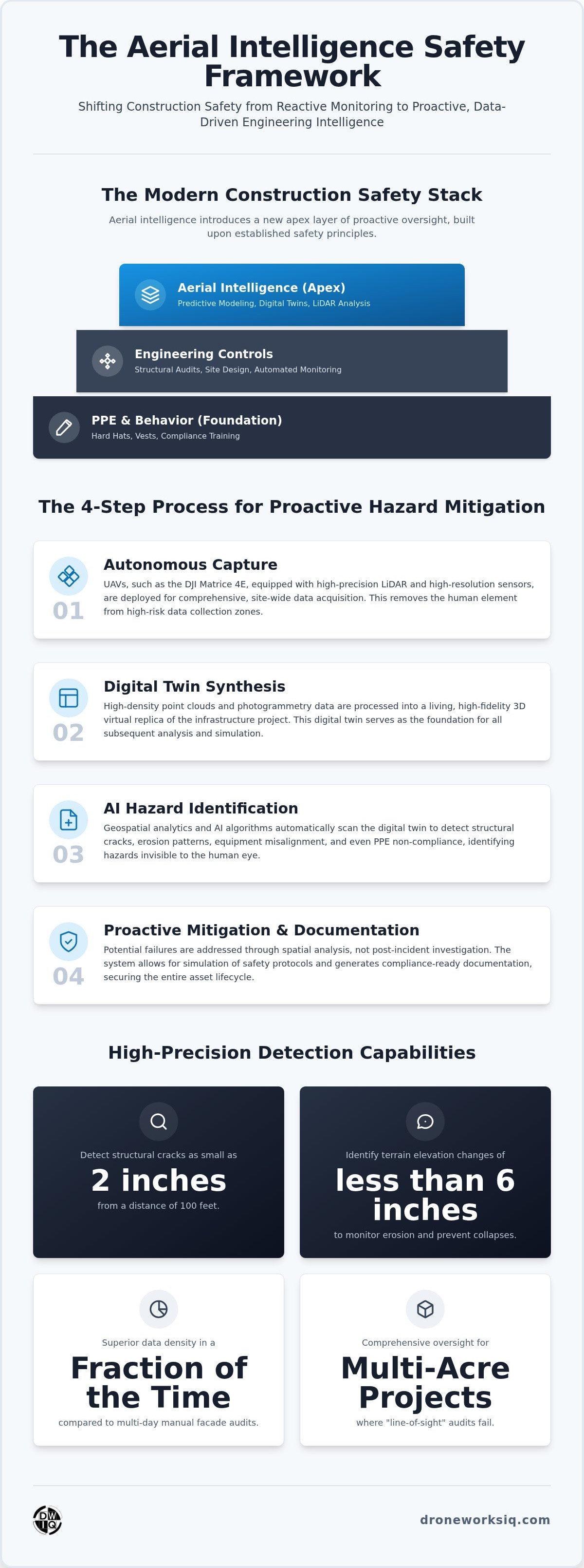
Aerial safety intelligence is the systematic integration of UAV-collected geospatial data into enterprise risk management frameworks. This methodology supersedes the historical reliance on reactive PPE compliance by establishing a proactive oversight layer. Traditional safety frameworks prioritize worker behavior; however, aerial intelligence focuses on auditing the physical environment autonomously. This shift is critical for improving construction site safety on multi-acre infrastructure projects where manual "line-of-sight" audits fail to capture the full scope of spatial risk.
By utilizing Lidar and high-resolution photogrammetry, operators generate a comprehensive data environment that identifies hazards before they manifest as incidents. Ground-level sensors and human observers possess inherent biological limitations. They can't consistently monitor structural stability across a 50 acre site or detect millimeter-level shifts in retaining walls. Aerial platforms provide the frequency and precision necessary to transform safety from a checklist into a data-driven engineering discipline.
The Limitations of Traditional Manual Inspections
Manual facade and utility inspections represent some of the highest risk activities in the construction lifecycle. Deploying personnel on ladders or scaffolding to heights exceeding 60 feet introduces significant fall liabilities. These methods are also chronologically inefficient. A manual audit of a high-rise facade may take several days, whereas an autonomous aerial scan provides superior data density in a fraction of the time. These automated methodologies are essential for improving construction site safety by removing the human element from high-risk data collection zones.
Identifying Structural and Environmental Blind Spots
Traditional safety plans often suffer from static information. They fail to account for subtle terrain shifts or gradual structural degradation that occurs between inspection cycles. Aerial intelligence provides repeatable, evidence-based data that reveals these "blind spots." Whether it's monitoring a pipeline corridor or a bridge support, the DroneWorksIQ approach ensures that engineering intelligence remains the primary driver of site safety. This level of oversight ensures that potential failures are identified through spatial analysis rather than post-incident investigation.
Key Takeaway: Engineering intelligence provides a comprehensive oversight layer that ground-level sensors cannot match.
High-Precision LiDAR for Structural Hazard Identification
High-precision LiDAR technology provides a level of geospatial fidelity that renders traditional manual reviews obsolete. While manual site reviews often miss sub-inch structural anomalies, advanced LiDAR sensors capture millions of discrete data points to generate high-density point clouds. These systems identify structural cracks as small as 2 inches from a distance of 100 feet. This capability is foundational for improving construction site safety, as it enables the detection of physical hazards invisible to the human eye before they escalate into catastrophic failures. High-resolution photogrammetry complements this by documenting equipment alignment and ensuring asset placement adheres strictly to engineering specifications.
Erosion Monitoring and Terrain Stability
Terrain instability remains a primary cause of trench collapses and site-wide accidents. LiDAR terrain analysis detects elevation changes of less than 6 inches in excavation zones, providing early warning signals for soil displacement. By integrating autonomous data collection, safety managers monitor site drainage patterns with mathematical precision. This data-driven approach identifies water accumulation zones that cause slip-and-fall hazards, allowing for proactive mitigation. For projects requiring continuous oversight, our LiDAR data collection and analysis services provide the evidentiary basis for site-wide stability.
Facade and Utility Inspection Safety
Traditional inspection methods require personnel to ascend high-rise facades or utility towers, introducing significant fall risks. Aerial intelligence eliminates this necessity. Deploying specialized hardware for infrastructure inspection allows for comprehensive data acquisition without human exposure to vertical risks. These autonomous systems navigate complex geometries to identify structural degradation, ensuring that high-rise inspections remain efficient and evidence-based while improving construction site safety.
Key Takeaway: High-precision sensors detect physical hazards invisible to the human eye, enabling intervention before failure.
Infrastructure Digital Twins: Predictive Safety Modeling
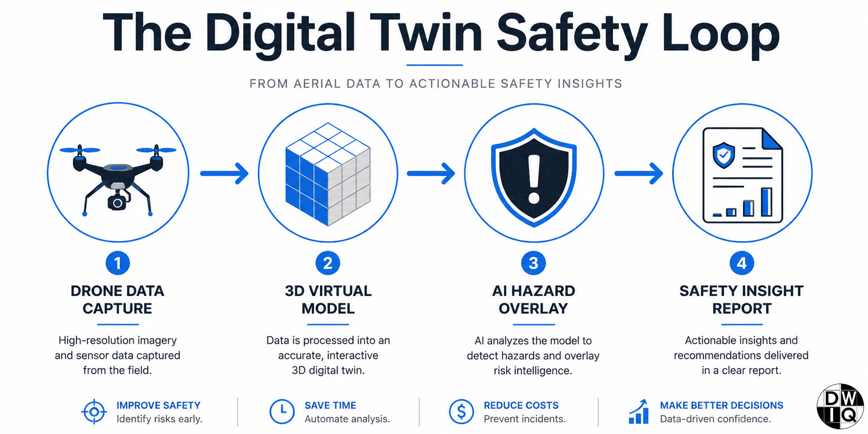
An infrastructure digital twin functions as a high-fidelity virtual replica of the physical job site, maintained through continuous geospatial synchronization. This technology provides the computational foundation for predictive modeling, moving beyond the detection of current hazards to the simulation of future risks. It represents a significant advancement in improving construction site safety by enabling safety officers to visualize complex spatial interactions before they occur on the ground. Predictive modeling is the most effective tool for improving construction site safety in 2026, as it replaces guesswork with evidence-based simulation.
The safety simulation process follows a methodical four-step framework designed to eliminate operational uncertainty:
Data capture: Autonomous acquisition of high-density point clouds and imagery via specialized sensors.
3D modeling: Processing raw geospatial data into a geometrically accurate, living virtual environment.
Hazard overlay: Integrating AI-driven analytics to identify potential collision points and structural stress zones.
Protocol testing: Running iterative simulations within the model to verify the safety of planned workflows.
Simulating High-Risk Workflows
Utilizing digital twin construction site models allows project managers to optimize crane swing radiuses and material staging areas with sub-inch precision. AI-driven systems analyze these models to predict collision risks between heavy machinery and temporary structures like scaffolding. This virtualization also enhances worker safety through immersive orientation. Personnel can identify site-specific hazard zones in the virtual model before arrival, significantly reducing the likelihood of accidental incursions into restricted or high-risk areas.
Leverage our digital twinning services to transform your site safety from reactive monitoring to predictive engineering intelligence.
Key Takeaway: Digital twins allow safety officers to 'test' safety protocols in a virtual environment before implementation.
Synthesizing Engineering Intelligence for National Site Safety
The DroneWorksIQ Platform serves as the centralized hub for converting raw geospatial data into actionable engineering intelligence. Manual documentation methods often remain disconnected from real-time site conditions; however, this integrated environment facilitates a continuous stream of evidence-based insights. Utilizing construction intel drone survey data creates an immutable record for asset lifecycle management. It ensures every safety intervention is documented with sub-inch accuracy. This systematic approach is the primary driver for improving construction site safety. It replaces subjective ground observations with repeatable, high-fidelity metrics that withstand rigorous audit scrutiny.
The financial justification for autonomous safety systems is rooted in risk mitigation and operational efficiency. High-performance entities recognize that aerial data isn't merely a supplementary tool. It's a core component of a strategic safety framework. Organizations implementing these high-tech oversight layers frequently experience reduced insurance premiums and minimized project delays caused by incident investigations. By identifying structural and environmental hazards before they result in failure, aerial intelligence protects both human capital and project timelines. Data-driven oversight is the only pathway to a zero-accident site.
Achieving Regulatory Compliance through Evidence-Based Data
Standardizing reporting for OSHA and national safety audits requires a transition from manual checklists to automated, evidence-based data streams. The DroneWorksIQ Platform generates compliance-ready documentation that satisfies rigorous regulatory requirements through objective spatial analysis. Every safety decision becomes defensible when backed by engineering-grade evidence. This level of transparency is essential for improving construction site safety across national infrastructure projects. The scale of modern operations demands a level of oversight that manual labor cannot provide.
Key Takeaway: True site safety is achieved when aerial intelligence is integrated into the core engineering workflow.
Securing Operational Continuity through Geospatial Intelligence
The adoption of autonomous aerial intelligence establishes a new benchmark for improving construction site safety by replacing reactive behavioral monitoring with proactive engineering oversight. Through the deployment of engineering-grade LiDAR precision, project managers identify structural anomalies and terrain instabilities with mathematical certainty. AI-driven geospatial hazard detection further enhances this capability, providing a continuous stream of intelligence that informs every stage of the asset lifecycle. This methodology ensures that safety is no longer a variable but a quantifiable engineering output.
Synthesizing these data streams into a centralized digital twin allows for the simulation of high-risk workflows; it's the most effective way to ensure that safety protocols are validated in a virtual environment before ground-level execution. Our national enterprise deployment capabilities provide the scale and technical depth required to standardize these high-tech safety frameworks across complex infrastructure projects. This systematic integration of geospatial data into the core engineering workflow minimizes liability while maximizing operational continuity. By prioritizing data-driven oversight, organizations secure both their human capital and their project timelines.
Transform your site safety with DroneWorksIQ's aerial intelligence platform. We look forward to partnering with you to engineer a safer, data-driven future for the construction industry.
Frequently Asked Questions
How does LiDAR technology specifically help in improving construction site safety?
LiDAR technology enhances site safety by facilitating high-fidelity geospatial data acquisition that identifies sub-inch structural anomalies and terrain instabilities. By capturing millions of discrete data points, these sensors detect stress fractures as small as 2 inches from a distance of 100 feet. This level of precision allows engineering teams to intervene before structural failures occur, significantly improving construction site safety through proactive hazard mitigation rather than reactive response.
Can drone mapping replace traditional manual safety inspections?
Drone mapping functions as a high-performance augmentation to traditional inspections by removing personnel from high-risk environments like high-rise facades or utility corridors. While manual audits provide ground-level context, aerial systems deliver superior data density and repeatable, evidence-based metrics. This transition minimizes human exposure to fall risks and structural collapses while providing a comprehensive oversight layer that manual observations can't achieve on large-scale infrastructure projects.
What are the primary safety benefits of a construction site digital twin?
The primary benefit of a construction site digital twin is the capacity for predictive safety modeling and workflow simulation. By maintaining a living virtual replica of the site, safety officers can test crane movements and material staging protocols in a risk-free environment. This virtualization identifies potential collision points between heavy machinery and temporary structures before they manifest physically, establishing a proactive framework for maintaining zero-accident job sites.
Is aerial data collection compliant with OSHA safety standards?
Aerial data collection is fully compatible with OSHA safety standards and provides the evidence-based documentation required for national safety audits. The DroneWorksIQ Platform generates standardized, repeatable metrics that exceed the accuracy of manual reporting. Every safety intervention is backed by engineering-grade data, ensuring that site-wide compliance is an immutable record within the asset lifecycle management system rather than a subjective observation.
How often should autonomous aerial inspections be conducted for maximum safety?
Inspection frequency depends on project complexity and the specific phase of the asset lifecycle. For high-risk activities like excavation or structural assembly, weekly or bi-weekly autonomous scans ensure the identification of subtle terrain shifts or material degradation. Maintaining a consistent data stream is essential for improving construction site safety, as it allows AI-driven analytics to detect environmental changes that occur between traditional monthly manual inspection cycles.
Originally published by DroneWorksIQ. Legacy source.