
INSIGHTS
LiDAR Digital Twin Services: An Enterprise Procurement and Implementation Framework (2026)
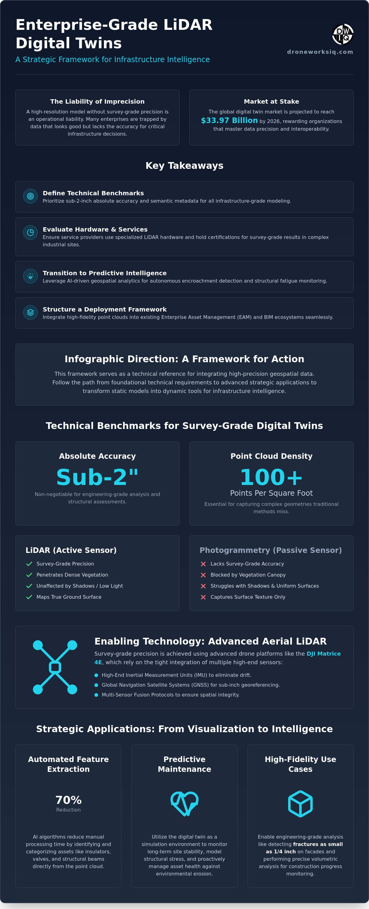
What if your high-resolution 3D model is actually an operational liability rather than a strategic asset? While the global digital twin market is projected to reach $33.97 billion in 2026, many enterprise leaders remain trapped by data silos and interoperability gaps that prevent cross-departmental utility. Procurement of LiDAR digital twin services often fails when decision-makers prioritize visual aesthetics over survey-grade precision. Without sub-2-inch accuracy and adherence to the EN 18162:2026 standard, these models remain static visualizations instead of dynamic tools for infrastructure intelligence.
It's common to struggle with the high costs of inaccurate surveys and the friction between raw point clouds and existing BIM workflows. This framework serves as a technical reference for evaluating and integrating high-precision geospatial data into your operational ecosystem. You'll learn how to move beyond basic mapping to achieve a survey-grade digital replica that fuels predictive maintenance and strategic oversight. We'll detail the procurement specifications, AI-driven feature extraction methods, and the multi-sensor fusion protocols necessary for 2026 enterprise standards.
Technical Specifications of LiDAR-Derived Digital Twins
An enterprise-grade LiDAR digital twin constitutes a survey-accurate, georeferenced 3D point cloud integrated with semantic metadata. This transcends basic visualization. To meet infrastructure standards, procurement must mandate sub-2-inch absolute accuracy. High-density point clouds, specifically those exceeding 100 points per square foot, ensure the capture of complex geometries that low-resolution alternatives miss. Unlike photogrammetry, which relies on passive light and struggles with shadowed regions or dense vegetation, digital twin technology powered by active LiDAR sensors penetrates canopy cover to map the true ground surface and structural foundations. LiDAR digital twin services deliver the granular detail necessary for national-scale asset oversight, providing a foundation for engineering-grade analysis that traditional photography cannot replicate.
Point Cloud Density and Precision Standards
Establishing a baseline for survey-grade data requires more than high pulse rates. In national utility corridors, sub-inch georeferencing is non-negotiable. This precision relies on the tight integration of high-end Inertial Measurement Units (IMU) and Global Navigation Satellite Systems (GNSS). Without this sensor fusion, the resulting model lacks the spatial integrity required for structural fatigue analysis. Professional LiDAR digital twin services utilize these integrated systems to eliminate drift and ensure every point represents a precise coordinate in three-dimensional space, rivaling the accuracy of traditional CAD data without the manual labor of legacy surveying.
Data Formats and Interoperability
Operationalizing these datasets requires seamless integration into existing workflows. Standardizing on LAS/LAZ and E57 formats facilitates immediate ingestion into Building Information Modeling (BIM) and Computer-Aided Design (CAD) software. This interoperability ensures that the high-fidelity data remains accessible across departments. Aligning these formats with an infrastructure digital twin platform enables stakeholders to move from raw data to actionable intelligence. It's essential to avoid proprietary software constraints that create new data silos, favoring open standards that support long-term asset management and cross-platform accessibility.
Strategic Applications: From Visualization to Predictive Intelligence
The evolution of LiDAR digital twin services has shifted the focus from passive 3D representation to active operational intelligence. By integrating AI-driven geospatial analytics, enterprises can automate the identification of encroachment and structural fatigue across vast utility corridors. This transition is essential for the strategic applications of digital twins in high-stakes industries where manual inspection is no longer viable. High-resolution LiDAR combined with thermal overlays allows for the detection of fractures as small as 1/4 inch on high-rise facades. This provides a level of detail that ensures structural integrity without the risk of manual scaffolding. In construction, volumetric analysis provides precise progress monitoring. It quantifies earthwork and material stockpiles with mathematical certainty, ensuring project timelines remain aligned with physical reality.
Automated Feature Extraction
Predictive Maintenance Modeling
Predictive maintenance modeling utilizes the digital twin as a simulation environment. By applying LiDAR terrain analysis, organizations monitor long-term site stability and environmental erosion. These models simulate structural stress under varying environmental conditions. This enables a proactive approach to asset health. To implement these advanced workflows effectively, organizations often require expert digital twinning services to bridge the gap between raw data and actionable insights. This methodical approach transforms a static model into a persistent, living record of infrastructure health.
Evaluation Criteria for LiDAR Digital Twin Service Providers
Selecting qualified vendors for LiDAR digital twin services necessitates a rigorous audit of hardware specifications and regulatory compliance. Enterprise-level data acquisition requires the utilization of survey-grade LiDAR sensors, such as those produced by Riegl or Velodyne, to ensure the spatial integrity of the final model. Technical vetting must include the verification of pilot certifications and specific national operational waivers for complex infrastructure environments. These authorizations are essential for lawful data collection in restricted or high-density corridors. Additionally, data security protocols must align with national standards for sensitive utility data protection. Scalable processing pipelines are mandatory for multi-site enterprise deployments, ensuring that data volume does not compromise delivery timelines.
Procurement Checklist: Key Technical Questions
A standardized evaluation of LiDAR digital twin services ensures that delivered datasets meet rigorous engineering requirements. Decision-makers should prioritize the following technical inquiries during the vetting process:
Absolute Accuracy Validation: Does the provider deliver comprehensive accuracy reports verified by independent ground control points?
Processing Efficiency: What is the established turnaround time from raw point cloud acquisition to a processed, BIM-ready model?
Scalability: Can the processing pipeline handle simultaneous multi-site enterprise deployments without data degradation?
Total Cost of Ownership (TCO) Analysis
Evaluating the financial impact of high-precision remote sensing requires a shift from initial collection fees to long-term operational savings. High-fidelity models provide a significant return on investment by reducing manual field visits by up to 90%. This reduction in physical site access minimizes safety risks and travel expenditures. Accurate digital twins prevent costly project delays caused by inaccurate legacy surveys. For organizations seeking to optimize their infrastructure management, engaging with a strategic partner for LiDAR data collection and analysis ensures the delivery of actionable intelligence that justifies the initial capital expenditure.
Operationalizing Geospatial Intelligence: Deployment and Integration
Data Management and Cloud Infrastructure
Handling multi-terabyte datasets requires specialized geospatial cloud platforms. These systems provide the computational power necessary for rendering high-density models without local hardware constraints. Implementing version control for digital twins is critical for tracking asset degradation over time. By comparing sequential scans, engineers can perform temporal analysis to identify subtle structural shifts or environmental erosion. This methodical approach ensures that data remains structured and accessible across the entire enterprise lifecycle.
Conclusion: The Future of Autonomous Infrastructure Intelligence
LiDAR digital twin services have become a cornerstone of industrial strategy in 2026. They move beyond simple mapping to provide the foundational intelligence required for autonomous operations and predictive maintenance. This transition from static observation to dynamic oversight is the primary driver of modern asset reliability. This framework provides the technical path for leaders to secure their infrastructure through high-resolution geospatial data.
Key Takeaway: Precision in the digital world is the only way to ensure safety in the physical world.
Advancing Enterprise Asset Intelligence
The transition from manual inspection to autonomous oversight depends on the deployment of survey-grade LiDAR digital twin services. By prioritizing sub-2-inch absolute accuracy and AI-driven feature extraction, organizations secure a persistent record of structural health across national-scale infrastructure. This framework ensures that geospatial data integrates seamlessly with existing enterprise systems, transforming raw point clouds into actionable intelligence for predictive maintenance. Precision in the digital environment is the prerequisite for safety and efficiency in physical asset management. Organizations that adopt these high-resolution standards position themselves at the forefront of industrial innovation, ensuring long-term reliability and reduced operational risk.
As you scale your digital twinning initiatives, leveraging specialized expertise in infrastructure intelligence is paramount. Consult with our technical experts on your LiDAR digital twin requirements to ensure your enterprise assets benefit from survey-grade accuracy and advanced geospatial analytics. Implementing these sophisticated data strategies today will secure your operational advantage; it's the most effective path toward long-term asset health.
Frequently Asked Questions
What is the difference between LiDAR and photogrammetry for digital twins?
LiDAR utilizes active laser pulses to measure distance directly, whereas photogrammetry relies on passive image reconstruction from 2D photographs. This distinction is critical for infrastructure projects where vegetation penetration or low-light performance is required. LiDAR digital twin services provide a direct 3D point cloud that captures structural geometry even in shadowed recesses. Photogrammetry often fails to map ground surfaces under dense canopy or within complex structural voids where visual contrast is absent.
How accurate are LiDAR digital twin services for national infrastructure?
Enterprise-grade LiDAR digital twin services typically achieve sub-2-inch absolute accuracy across national infrastructure corridors. This level of precision is facilitated by the integration of high-performance Inertial Measurement Units and Global Navigation Satellite Systems. These systems eliminate spatial drift during data acquisition. Survey-grade sensors ensure that every point within the georeferenced cloud represents a precise coordinate, providing the mathematical certainty required for engineering analysis and structural fatigue monitoring.
Can LiDAR digital twins be used for indoor and outdoor building inspections?
LiDAR digital twins are effective for both indoor and outdoor building inspections through the use of specialized aerial and terrestrial scanning systems. Aerial systems map facades and roof structures, identifying defects as small as 1/4 inch. For interiors, mobile mapping systems utilizing Simultaneous Localization and Mapping technology generate precise models of mechanical rooms and structural supports. This dual approach provides a comprehensive record of the entire facility, enabling remote oversight of all critical systems.
What file formats are standard for LiDAR-derived digital twins?
The standard industry formats for LiDAR-derived models are LAS, LAZ, and E57. These formats ensure interoperability between raw data collection systems and existing Building Information Modeling or Computer-Aided Design platforms. LAS and its compressed version, LAZ, are the primary formats for point cloud data storage. E57 is frequently utilized for its ability to store high-resolution imagery alongside spatial coordinates, facilitating a more detailed representation of the physical asset during the integration phase.
How often should a digital twin be updated with new LiDAR scans?
Update frequency is determined by asset criticality and the rate of environmental change surrounding the infrastructure. High-risk utility corridors or construction sites often require quarterly updates to maintain data freshness and track asset degradation. For stable infrastructure, annual scans may suffice unless a significant event, such as a major storm, occurs. Routine autonomous updates ensure the digital twin remains a reliable source of truth for predictive maintenance and strategic decision-making.
Originally published by DroneWorksIQ. Legacy source.