
INSIGHTS
The Prosumer Drone Gap: Why Enterprise Data Needs More
The deployment of sub-$5,000 hardware for critical infrastructure analysis represents a fundamental misunderstanding of the requirements for engineering-grade precision. While the accessibility of high-end consumer models suggests a simplified entry into aerial data collection, the reality is a persistent prosumer drones gap that compromises the integrity of geospatial outputs. Technical decision-makers often discover that these systems lack the sensor sophistication required for sub-1-inch accuracy or reliable performance in complex industrial environments.
We acknowledge that the pressure to minimize capital expenditure is significant, yet the resulting data-fidelity crisis often necessitates costly re-flights and manual corrections. This article analyzes the technical and operational limitations inherent in prosumer hardware while establishing a clear threshold for enterprise-grade hardware selection. You will discover how the transition to advanced aerial intelligence enables the integration of autonomous data into existing engineering workflows for repeatable asset lifecycle management. We examine the transformation of raw imagery into high-fidelity infrastructure models that meet the most rigorous regulatory standards.
Key Takeaways
Identify the hardware plateau where prosumer sensor limitations impede the generation of high-fidelity geospatial data for industrial application.
Analyze the prosumer drones gap to understand the technical transition from raw visual imagery to actionable, engineering-grade digital twins.
Utilize specialized LiDAR data collection to achieve sub-1-inch accuracy, ensuring comprehensive terrain oversight even in dense vegetation or complex environments.
Establish repeatable data-to-decision workflows that align autonomous aerial intelligence with rigorous regulatory compliance and asset lifecycle management.
The Prosumer Drones Gap: Identifying the Ceiling of Consumer-Grade Hardware
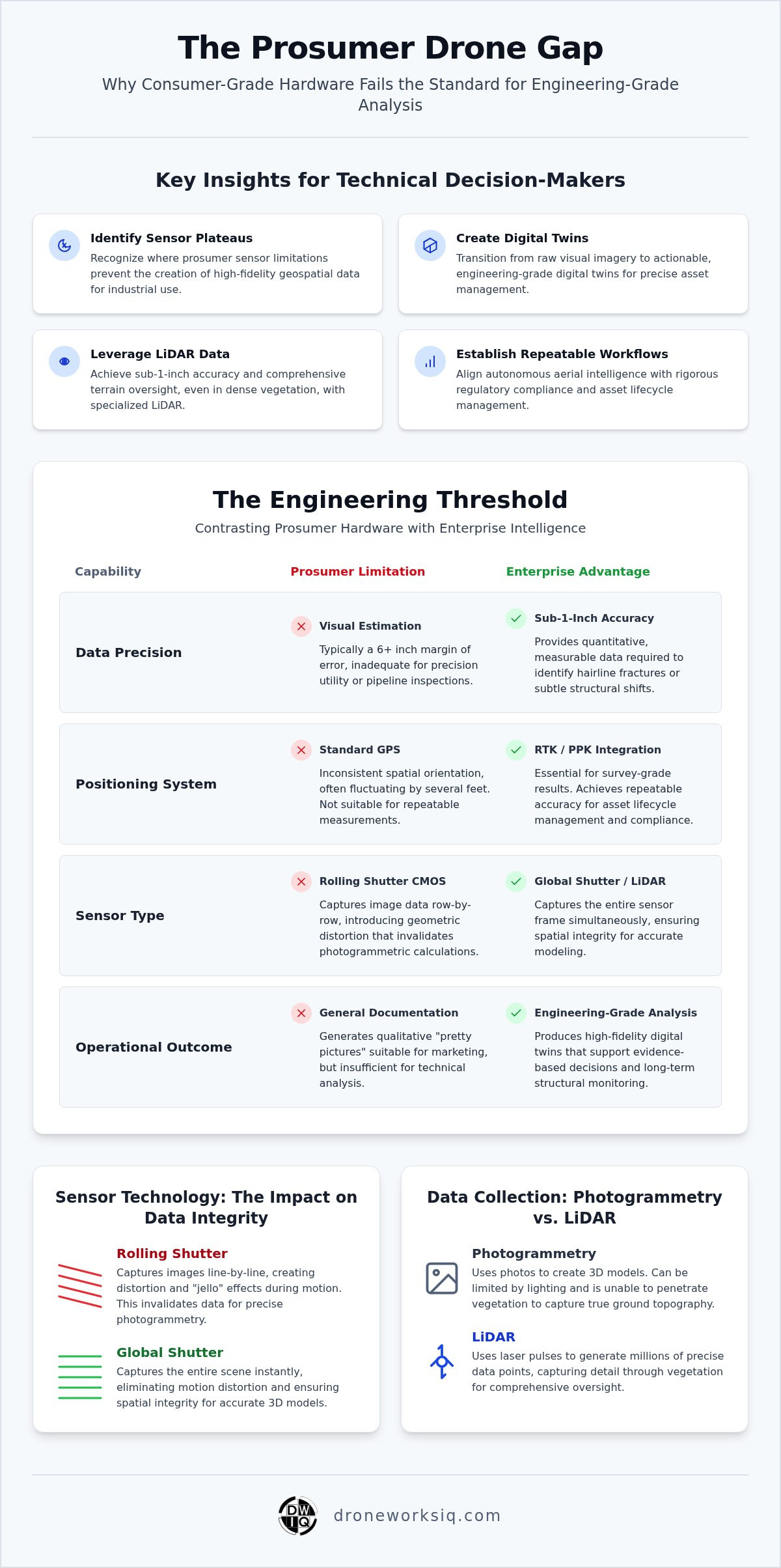
The prosumer drones gap represents the technical performance delta where high-end retail UAV architecture fails to meet the rigorous requirements of enterprise aerial intelligence. While legacy platforms like the DJI Phantom series successfully pioneered accessible aerial perspectives, their hardware remains optimized for visual aesthetics rather than engineering-grade geospatial fidelity. This hardware plateau creates a critical failure point in high-accuracy infrastructure mapping. Enterprise operations demand a transition from "photography" to systematic geospatial data collection, prioritizing evidence-based outputs over mere visual documentation. In complex industrial environments, the clinical assessment of flight endurance and signal reliability reveals that consumer-grade systems lack the shielding and redundant link stability necessary for high-stakes oversight.
Sensor Limitations and Optical Deficiencies
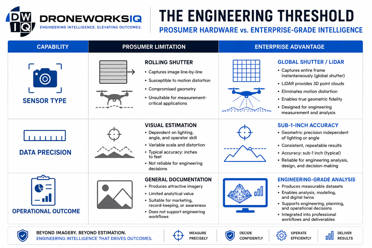
Prosumer hardware typically utilizes rolling shutter CMOS sensors, which capture image data row-by-row. During high-velocity flight, this sequential capture introduces geometric distortion that invalidates photogrammetric calculations. Enterprise systems utilize global shutters to capture the entire sensor frame simultaneously, ensuring spatial integrity. A standard 20-megapixel prosumer sensor frequently lacks the optical MTF (Modulation Transfer Function) to achieve the ground sampling distance required for sub-1-inch facade inspections. This deficiency results in blurred textures that obscure critical structural defects during digital twin generation.
Positioning Accuracy: The RTK and PPK Threshold
Standard GPS positioning integrated into consumer units provides inconsistent spatial orientation, often fluctuating by several feet. For national utility corridor mapping, horizontal accuracy exceeding 6 inches is operationally unacceptable. The prosumer drones gap is most pronounced in the absence of native Real-Time Kinematic (RTK) or Post-Processed Kinematic (PPK) hardware. These systems are essential for achieving the repeatable accuracy required for asset lifecycle management. Without integrated kinematic positioning, aerial data remains a subjective snapshot rather than a precise engineering coordinate, rendering it useless for long-term structural monitoring or regulatory compliance.
Precision Thresholds: Why Engineering-Grade Data Exceeds Visual Documentation
Engineering intelligence requires the transition from a qualitative visual record to a quantitative measurable model. While prosumer hardware generates high-resolution imagery suitable for marketing or basic site overviews, it often fails to meet the spatial accuracy requirements for critical infrastructure analysis. This technical discrepancy defines the prosumer drones gap, where the lack of sensor calibration and high-precision positioning prevents the creation of survey-grade digital twins. For engineering professionals, a "pretty picture" is insufficient; the data must represent a geometrically accurate reflection of the physical asset to facilitate long-term lifecycle management and structural calculations.
The integration of advanced sensors like LiDAR provides a distinct advantage over standard photogrammetry, particularly in complex industrial environments. High-performance LiDAR systems possess the capability to penetrate dense vegetation, capturing true ground topography that remains obscured in consumer-grade optical captures. This ability to generate millions of precise data points ensures that the resulting models provide the comprehensive oversight necessary for drones to map and manage construction sites with absolute precision. Establishing repeatability is a core engineering requirement. Without it, longitudinal studies of asset degradation or erosion monitoring become statistically invalid.
Photogrammetry vs. LiDAR Accuracy Standards
Data fidelity varies significantly between hardware tiers. Prosumer photogrammetry often carries a 6-inch margin of error, which is inadequate for precision utility or pipeline inspections. In contrast, enterprise-grade LiDAR point cloud analysis achieves sub-1-inch precision, providing the point density required to identify hairline fractures or subtle structural shifts. This level of detail is essential for generating high-fidelity digital twins that support evidence-based decision-making. Organizations seeking this level of technical oversight should evaluate specialized LiDAR data collection and analysis to ensure their geospatial outputs meet industrial standards.
Data Transformation: From Raw Pixels to Actionable Intelligence
The transformation of aerial data into engineering intelligence relies on AI-driven geospatial analytics. Prosumer software ecosystems generally lack the sophisticated processing algorithms needed to identify specific structural anomalies automatically. Enterprise-grade platforms utilize complex nominalizations and data science methodologies to categorize defects, calculate volumes, and monitor asset health with clinical accuracy. This systematic approach ensures that reporting is compliance-ready, providing the rigorous documentation required by regulatory bodies in the energy and transportation sectors.
Risk, Compliance, and Lifecycle Management: The Operational Gap
Reliance on non-engineering grade data for critical infrastructure decisions introduces significant operational liability. In oil, gas, and transportation sectors, regulatory compliance necessitates evidence-based documentation adhering to rigorous national standards. Prosumer hardware fails to provide the requisite audit trail or technical precision for these high-stakes environments. The prosumer drones gap becomes a bottleneck when organizations scale from localized flights to national autonomous data collection. Addressing the primary objection regarding cost reveals that professional aerial intelligence reduces long-term operational expenditure (OPEX). High-fidelity data minimizes manual ground intervention and mitigates risk through predictive modeling.
Infrastructure Asset Inspection Protocols
Repeatable workflows are essential for erosion monitoring and digital twinning. Maintaining compliance with national engineering standards requires data consistency that retail systems can't sustain. Integrating advanced Infrastructure Inspection strategies ensures that data remains a reliable asset throughout its lifecycle. This methodical approach ensures that structural assessments are grounded in empirical evidence rather than visual estimation.
Strategic Insights Through AI Analytics
Transforming raw data into strategic insights for agri-health and pipeline management involves sophisticated geospatial analytics. The evolution of autonomous infrastructure intelligence facilitates the oversight of large-scale assets with clinical accuracy. Organizations requiring this level of oversight can leverage the DroneWorksIQ Platform for comprehensive asset intelligence and data-driven decision-making across their entire infrastructure portfolio.
Strategic Integration: Bridging the Capability Gap with DroneWorksIQ
The DroneWorksIQ Platform functions as a centralized intelligence layer that transforms disparate aerial captures into a unified infrastructure oversight ecosystem. While the prosumer drones gap introduces significant technical debt through hardware-induced inaccuracies, specialized LiDAR data collection establishes a definitive ground truth for asset lifecycle management. This clinical approach eliminates the uncertainty inherent in retail-grade sensors. It ensures that every data point contributes to a repeatable, evidence-based geospatial record. Engineering confidence is maintained by linking technological capabilities directly to strategic industrial outcomes, facilitating a systematic transition from raw imagery to actionable intelligence.
Key Takeaway and Strategic Framework
Key Takeaway: The prosumer gap is bridged through the integration of high-fidelity sensors and AI-driven analytics, moving beyond visual records to engineering-grade intelligence.
Implementing Enterprise Aerial Intelligence
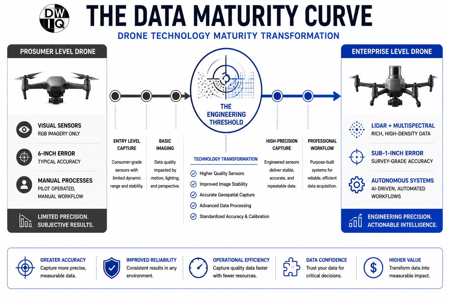
Transitioning from decentralized prosumer testing to professional LiDAR data analysis requires a methodical shift in organizational focus. Organizations must prioritize the generation of high-fidelity digital twins to monitor construction site progress and maintain rigorous asset documentation. This evolution allows for the seamless integration of autonomous data into existing engineering workflows. Leveraging the DroneWorksIQ Platform provides the necessary oversight for large-scale operations. It's a strategic move that replaces visual estimation with clinical precision. This shift ensures that geospatial outputs meet the stringent requirements of modern infrastructure management while reducing long-term operational friction.
Advancing Asset Intelligence Beyond the Prosumer Threshold
The transition from visual documentation to engineering intelligence requires a fundamental shift in hardware selection and data processing methodology. Analysis confirms the prosumer drones gap represents a geometric fidelity crisis that compromises long-term asset lifecycle management. Organizations must move beyond the hardware plateau of consumer-grade sensors to embrace specialized LiDAR data collection and analysis. This evolution ensures geospatial outputs meet rigorous national engineering standards while providing the repeatable, evidence-based documentation necessary for regulatory compliance in high-stakes sectors like oil, gas, and transportation.
Achieving sub-1-inch accuracy for infrastructure modeling demands the integration of high-fidelity sensors and AI-driven geospatial analytics. Consolidating disparate imaging into a unified intelligence platform provides comprehensive national coverage for large-scale operations. Mitigating operational risk and optimizing lifecycle expenditure relies on this level of clinical technical oversight. It's the only path toward securing engineering-grade digital twins that withstand industrial scrutiny.
Transform your aerial data into engineering intelligence with DroneWorksIQ
We're prepared to secure your transition toward superior data fidelity.
Frequently Asked Questions
What is the primary technical difference between prosumer and enterprise drones?
The primary technical difference lies in sensor architecture and positioning integration. Enterprise systems utilize global shutters and native RTK hardware to eliminate geometric distortion and ensure high-precision spatial orientation. Prosumer models often rely on rolling shutters and standard GPS, which introduce spatial inconsistencies during high-velocity flight. This distinction is critical for generating the repeatable, survey-grade data required for infrastructure modeling and long-term asset lifecycle management.
How does LiDAR data collection improve accuracy over standard photogrammetry?
LiDAR improves accuracy by utilizing active laser pulses to penetrate dense vegetation and capture true ground topography. Unlike standard photogrammetry, which depends on visual line-of-sight and ambient lighting, LiDAR generates high-density point clouds that remain unaffected by shadows or complex industrial environments. This capability ensures the generation of high-fidelity digital twins for pipeline and utility inspections, providing a level of detail that passive sensors cannot match.
Can prosumer drones be used for sub-1-inch engineering measurements?
Prosumer hardware cannot reliably achieve sub-1-inch engineering measurements due to the inherent prosumer drones gap in sensor calibration and positioning stability. These systems typically exhibit a margin of error exceeding 6 inches, which invalidates them for critical structural monitoring. Engineering-grade precision requires specialized optics and redundant systems found exclusively in enterprise-level aerial intelligence platforms to ensure data integrity across complex, high-stakes industrial environments.
What are the risks of using prosumer-grade data for infrastructure inspection?
Using prosumer-grade data for infrastructure inspection introduces significant liability and regulatory non-compliance risks. Inaccurate geospatial outputs compromise the integrity of asset lifecycle management and may lead to catastrophic failure through the oversight of subtle structural anomalies. The lack of repeatable workflows prevents the evidence-based documentation required by national engineering standards in the energy and transportation sectors, rendering the data insufficient for official audit requirements.
How does the DroneWorksIQ Platform integrate with existing engineering workflows?
The DroneWorksIQ Platform integrates with existing engineering workflows by providing a clinical, end-to-end data transformation layer. Raw aerial data is ingested and processed through AI-driven geospatial analytics to produce actionable engineering insights and high-fidelity digital twins. This systematic approach ensures that autonomous aerial data becomes a reliable component of strategic asset management, allowing for the seamless transition from raw imagery to evidence-based infrastructure oversight.
Originally published by DroneWorksIQ. Legacy source.