
INSIGHTS
Enterprise Building Facade Drone Survey: A Strategic Framework for Asset Intelligence (2026)
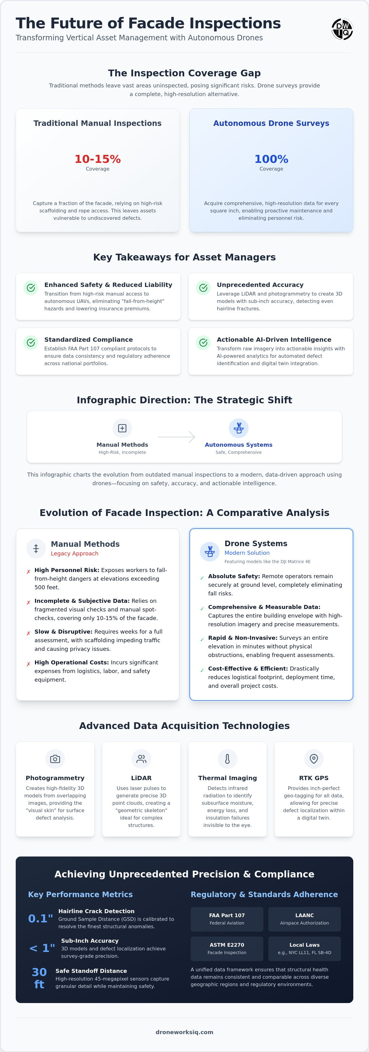
Traditional manual inspection methodologies capture a mere 10% to 15% of total facade surface area, leaving the vast majority of critical infrastructure data unobserved and unrecorded. For enterprise asset managers, the reliance on scaffolding and rope access represents an outdated paradigm characterized by high operational costs and significant safety liabilities. Implementing a building facade drone survey provides a systematic solution to these systemic inefficiencies, replacing fragmented visual checks with comprehensive, high-resolution data acquisition.
The unsustainable nature of manual vertical inspections is increasingly evident in large-scale portfolios where data fragmentation hinders strategic maintenance. This framework details how autonomous UAV systems and AI-driven analytics transform these inspections into precise, actionable infrastructure intelligence. We examine the deployment of standardized protocols and the generation of high-resolution 3D models that enable defect tracking with sub-inch accuracy, ensuring a significant reduction in operational downtime and structural risk across global portfolios.
The Evolution of Facade Inspection: From Manual Scaffolding to Autonomous UAV Systems
The transition from mechanical suspension systems to autonomous unmanned aerial systems (UAS) represents a fundamental shift in vertical asset management. Legacy inspection methods, including rope access and swing stages, require extensive lead times and complex logistical coordination. The Evolution of Facade Inspection has moved toward non-contact, high-frequency data acquisition that prioritizes speed and precision. This technological migration replaces personnel suspended at heights exceeding 500 feet with remote operators stationed securely at ground level. It's a strategic decoupling of human safety from critical data collection requirements.
Executing a building facade drone survey drastically reduces the logistical footprint associated with traditional multi-story assessments. Physical obstructions like scaffolding and sidewalk sheds frequently impede pedestrian traffic and trigger privacy complaints from building occupants. Autonomous flight profiles circumvent these physical constraints entirely. While traditional methods might require weeks for a full-envelope assessment, a UAS-based survey captures an entire elevation in minutes. This rapid deployment facilitates more frequent assessments. It transforms reactive maintenance into a proactive, data-driven strategy for enterprise portfolios.
Mitigating Structural Liability and Personnel Risk
The elimination of "fall-from-height" risks through autonomous flight paths directly addresses the most significant liability in vertical infrastructure management. High-performance optical sensors enable the detection of structural anomalies, such as hairline cracks measuring 0.1 inches, without physical contact. This precision ensures that structural health is monitored with granular detail while maintaining a safe standoff distance. Insurance providers recognize these non-contact modalities as a superior risk-mitigation strategy. For UK-based portfolios, WS Insurance Brokers can help asset managers leverage this high-resolution data to secure lower premiums and reduced litigation exposure. Data accuracy remains high. Safety remains absolute.
Technical Modalities of Drone-Based Facade Surveys: LiDAR vs. Photogrammetry
The technical efficacy of a building facade drone survey depends on the strategic selection of data acquisition modalities. LiDAR utilizes active laser pulses to generate high-density 3D point clouds, offering superior performance when mapping complex architectural geometries or structures with significant overhangs. This active sensing capability provides precise volumetric data regardless of ambient lighting conditions. In contrast, photogrammetry leverages overlapping high-resolution 2D imagery to reconstruct high-fidelity 3D models. While LiDAR provides the geometric skeleton, photogrammetry provides the visual skin. This allows engineers to identify surface-level defects with sub-inch accuracy.
Analytical depth is further enhanced by thermal imaging. These sensors detect infrared radiation to identify subsurface moisture entrapment and insulation failures that are invisible to the naked eye. To maintain structural integrity standards, the Ground Sample Distance (GSD) must be meticulously calibrated. A GSD of 0.1 inches or less ensures that hairline fractures are resolved during the building facade drone survey. This level of detail is necessary for the automated classification of material degradation across large-scale assets.
High-Resolution Visual and Thermal Data Acquisition
Deploying 45-megapixel sensors enables the capture of granular architectural details from a standoff distance of 30 feet. This resolution is critical for documenting the condition of fasteners, sealants, and masonry joints without physical contact. Integrating Real-Time Kinematic (RTK) GPS ensures that every image contains inch-perfect geo-tagging data. This spatial precision facilitates the exact localization of defects within a digital twin. Enterprise managers often utilize Drone Mapping and Photogrammetry Services to achieve this level of repeatable analytical depth.
Implementing a National Facade Inspection Protocol: Standards and Accuracy
Regulatory compliance within the commercial UAS sector necessitates a rigorous adherence to FAA Part 107 requirements. In dense urban canyons, the presence of signal attenuation and GPS multipath errors requires advanced flight controller redundancy and precise mission planning. Executing a building facade drone survey in these environments also demands strict coordination with the FAA's Low Altitude Authorization and Notification Capability (LAANC) system. National portfolio managers must move beyond localized compliance, such as NYC Local Law 11 or Florida's SB-4D milestone inspections, toward a unified data collection framework. This standardization ensures that structural health data remains comparable across diverse geographic regions.
ASTM E2270 standards for periodic facade inspections emphasize the necessity of "close-up" visual observations. UAV technology exceeds these traditional requirements by providing high-resolution, measurable records of every square inch of the building envelope. This methodology eliminates the subjective nature of manual spot checks. It replaces them with a comprehensive digital record. Managing the terabytes of high-resolution imagery generated during these surveys requires robust enterprise cloud architectures. Data must be encrypted and stored in SOC 2 compliant environments to maintain the integrity of structural vulnerability records. Standardizing these processes is essential for large-scale asset intelligence.
Data Precision and Error Margin Management
Maintaining sub-inch relative accuracy across a 40-story vertical surface requires stringent flight parameters. We mandate a minimum of 80% frontal and 80% side overlap during image acquisition to ensure seamless photogrammetric reconstruction. Consistent lighting conditions are vital to prevent shadow-induced artifacts that can obscure hairline fractures in the final model. This level of precision provides the necessary site context when integrated with enterprise drone mapping services. Our standardized approach ensures that every pixel is a data point for structural analysis.
Optimize your portfolio oversight and ensure regulatory compliance by utilizing our professional Facade Inspection Services.
Transforming Raw Imagery into Actionable Infrastructure Intelligence
The terminal value of a building facade drone survey lies in the algorithmic processing of high-resolution datasets rather than the mere acquisition of imagery. AI-driven analytics engines now facilitate the automated identification and classification of structural anomalies, including concrete spalling and metallic corrosion. This automated detection significantly reduces human error during the review phase. It allows engineers to focus on high-priority structural risks. This shift marks the transition from static inspection reports to dynamic infrastructure digital twin models. These twins serve as the central repository for an asset's structural history, providing a spatially accurate environment for long-term maintenance planning.
Integrating Facade Data into Enterprise Asset Management
Synchronizing UAV-derived data with existing Building Information Modeling (BIM) software creates a unified source of truth for facility managers. Utilizing temporal data from repeated surveys allows for the precise monitoring of material degradation rates and erosion patterns. This longitudinal analysis enables predictive maintenance strategies that address structural issues before they escalate into significant failures. Infrastructure Intelligence is defined as the strategic synthesis of high-frequency aerial data acquisition and AI-driven analytics to optimize asset longevity.
Operationalizing Advanced Vertical Asset Intelligence
The transition from manual, high-risk vertical assessments to a standardized building facade drone survey represents a critical advancement in industrial asset management. By integrating LiDAR and high-resolution photogrammetry, enterprise operators achieve a level of structural transparency that wasn't previously attainable. This framework ensures that data fragmentation is eliminated; it replaces subjective visual checks with measurable, AI-validated infrastructure intelligence. It's a system designed for long-term structural health monitoring and predictive maintenance cycles.
Scaling these operations across national portfolios requires a partner capable of navigating complex urban flight environments and managing massive geospatial datasets. DroneWorksIQ provides national coverage with FAA-certified pilots specialized in high-stakes urban canyons. Our AI-driven geospatial analytics ensure that every structural anomaly is identified with sub-inch precision, transforming raw imagery into actionable strategic insights. Consult with DroneWorksIQ on your national facade inspection strategy to optimize your asset oversight and mitigate structural liability. Elevating your inspection protocol ensures the sustained integrity of your most critical infrastructure.
Frequently Asked Questions
How accurate is a drone facade survey compared to manual inspection?
A building facade drone survey provides significantly higher data density than manual methods, capturing 90% to 100% of the envelope surface area. Manual inspections typically observe only 10% to 15% of the facade through ground-level visual checks or limited rope-access drop points. High-resolution sensors achieve a Ground Sample Distance (GSD) of 0.1 inches, allowing for the detection of hairline fractures and micro-cracking that human inspectors might overlook from a swing stage.
Can drones perform facade inspections in high-wind urban environments?
Modern enterprise-grade UAS platforms are engineered to maintain flight stability in sustained winds reaching 27 mph to 30 mph. Advanced flight controllers utilize real-time sensor fusion to counteract urban wind shear and the "canyon effect" frequently encountered between high-rise structures. For safety and data quality, operations are typically suspended if gusts exceed manufacturer-specified operational limits or if atmospheric visibility is compromised.
What are the FAA requirements for drone facade surveys in the United States?
Commercial drone operations in the United States require a pilot to hold an FAA Part 107 Remote Pilot Certificate. Operators must secure LAANC authorization for flights within controlled airspace and adhere to a maximum altitude of 400 feet above ground level. Additionally, aircraft must be equipped with Remote ID systems to broadcast identification and location data during the building facade drone survey to ensure full regulatory compliance.
How much does a building facade drone survey cost for a high-rise?
The financial investment for a UAS-based survey is determined by the total surface area, the complexity of the architectural geometry, and the required sensor payloads. While specific costs depend on project scope, autonomous surveys are documented to be 60% to 80% more cost-effective than traditional scaffolding or rope access methods. This efficiency stems from the elimination of heavy equipment mobilization and the reduction of total inspection time from weeks to hours.
Does a drone survey meet the requirements for Local Law 11 or FISP inspections?
UAS data serves as a primary evidence base for NYC Local Law 11 (FISP) and Florida Milestone Inspections under SB-4D and HB 913. While the drone captures the comprehensive visual and thermal data required for the assessment, a licensed professional engineer or architect must still review the findings and certify the final report. This integration of autonomous data capture and professional certification ensures full compliance with municipal safety regulations.
Originally published by DroneWorksIQ. Legacy source.