BVLOS Drone Delivery: Regulations and Public Challenges
- Dan

- 7 days ago
- 8 min read
Updated: 6 days ago
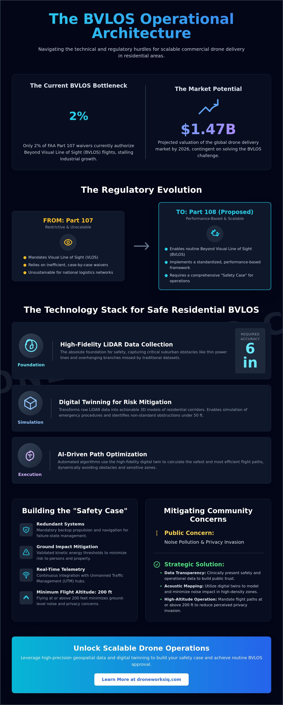
While the global drone delivery market accelerates toward a $1.47 billion valuation in 2026, the operational reality remains constrained. Only 2% of FAA Part 107 waivers currently authorize beyond visual line of sight (BVLOS) flights. Enterprise leaders understand that achieving scale requires navigating a complex intersection of federal mandates and localized pushback. The deployment of commercial drone deliver services BVLOS and the residential implications and local regulation issues and public resistance represent the primary barriers to sustained industrial growth. This report provides a clinical analysis of the technical and social hurdles facing the sector in 2026. You'll gain a comprehensive understanding of the proposed Part 108 framework and the strategic use of high-precision geospatial data to secure operational approval. We examine how the integration of LiDAR and digital twinning services mitigates risks associated with inaccurate obstacle avoidance and public backlash regarding noise and privacy at 200 ft altitudes.
Key Takeaways
Identify the operational transition from restrictive Part 107 visual constraints to the performance-based Part 108 framework for scalable BVLOS logistics.
Analyze the implementation of high-fidelity LiDAR data collection to achieve the 6 in navigational accuracy required for suburban obstacle avoidance.
Develop strategic frameworks to manage commercial drone deliver services BVLOS and the residential implications and local regulation issues and public resistance through clinical data transparency.
Utilize digital twinning and acoustic mapping to mitigate community backlash regarding noise pollution and perceived privacy invasions in high-density zones.
Infographic: The BVLOS Operational Architecture
[Technical illustration depicting the multi-layered integration of FAA Part 108 standards, LiDAR-driven obstacle deconfliction, and municipal land-use compliance protocols for residential drone delivery.]
The Evolution of BVLOS Regulation: Normalizing Part 108 and Part 135
The transition from experimental operations to industrialized logistics necessitates a shift from the restrictive FAA Part 107 visual line of sight (VLOS) requirements to a standardized, performance-based framework. FAA Part 108, currently in the Notice of Proposed Rulemaking (NPRM) phase as of June 2026, aims to replace the inefficient waiver-based system with routine Beyond Visual Line of Sight (BVLOS) authorizations. While Part 107 mandates continuous visual contact, commercial drone deliver services BVLOS and the residential implications and local regulation issues and public resistance require the more stringent Part 135 air carrier certification for package transportation. This certification demands rigorous airworthiness standards and operational oversight comparable to traditional aviation. Central to this evolution is the "Safety Case" requirement, which forces operators to demonstrate comprehensive risk mitigation strategies for flight over populated residential zones, including:
Redundant propulsion and navigation systems for failure-state management.
Validated kinetic energy thresholds for ground-impact mitigation.
Real-time telemetry integration with regional UTM hubs.
From Case-by-Case Waivers to Scalable Frameworks
The historical reliance on case-by-case waivers proved unsustainable for national logistics networks, with only 2% of Part 107 waivers currently addressing BVLOS operations. Scalability depends on the deployment of Unmanned Traffic Management (UTM) systems and the integration of Automated Data Service Providers (ADSPs). These entities facilitate real-time deconfliction and airspace awareness, moving the industry toward an overview of delivery drones that prioritizes automated safety protocols over manual pilot intervention.
Regulatory Thresholds for Residential Airspace
Safe operation within complex residential corridors requires high-fidelity spatial data. Operators increasingly rely on LiDAR data collection to map obstacles that traditional geospatial datasets overlook. Regulatory standards often mandate flight altitudes at or above 200 ft to minimize ground-level risks. Additionally, the proposed Part 146 framework will define the technical requirements for third-party UTM service integration, ensuring that diverse drone fleets can coexist within the same low-altitude sectors without collision risks. This structured approach is essential for overcoming the systemic hurdles associated with commercial drone deliver services BVLOS and the residential implications and local regulation issues and public resistance.
Geospatial Intelligence: The Foundation of Safe Residential Delivery
Safety in residential BVLOS operations is predicated on the absolute fidelity of the underlying geospatial dataset. Commercial drone deliver services BVLOS and the residential implications and local regulation issues and public resistance often stem from perceived safety risks in "last-mile" navigation where environmental variables are high. To mitigate these risks, operators must utilize LiDAR data collection to identify suburban obstructions such as thin power lines and overhanging branches with a minimum accuracy of 6 in. This level of precision is non-negotiable for autonomous deconfliction in complex zones where standard GPS-only navigation fails to account for vertical infrastructure.
LiDAR and Digital Twinning for Obstacle Avoidance
High-resolution terrain models serve as the structural framework for safe flight pathing. Through AI-driven geospatial analytics, raw point cloud data is transformed into actionable intelligence. Digital twins of residential corridors enable the simulation of emergency landing procedures before a single rotor spins. These models identify non-standard obstructions, such as temporary construction equipment or residential structures under 50 ft, which are frequently omitted from standard municipal maps. Strategic use of digital twinning services ensures that the autonomous system maintains a comprehensive understanding of the physical environment, reducing the probability of mid-air collisions.
The Role of AI in Path Optimization
Automated pathfinding algorithms rely on the extraction of specific features from aerial datasets to navigate sensitive zones. Research into Public Perception of Drone Delivery indicates that safety concerns and privacy anxieties are heightened in high-density areas. By leveraging AI-driven geospatial analytics, systems can automate the identification of "safe-to-land" zones, ensuring delivery drones remain clear of playgrounds or private balconies. This systematic approach transforms commercial drone deliver services BVLOS and the residential implications and local regulation issues and public resistance from a liability into a manageable operational variable. Real-time hazard detection allows the flight controller to recalculate trajectories instantly when new obstacles appear in the flight path.
Navigating Local Regulation and the "Death by a Thousand Papercuts"
The regulatory environment for commercial drone deliver services BVLOS and the residential implications and local regulation issues and public resistance is defined by a persistent jurisdictional tension between federal oversight and municipal authority. While the FAA maintains exclusive sovereignty over the National Airspace System, local governments exercise "police power" to regulate terrestrial activities including land use, zoning, and noise abatement. This creates a fragmented legal landscape where an operator may possess federal Part 135 certification yet remain grounded by municipal ordinances that restrict takeoff and landing on private or government-owned property. This phenomenon, often described as "death by a thousand papercuts," necessitates a localized strategy for every residential sector targeted for delivery expansion.
Federal Preemption vs. Local Land Use
The transition from the National Airspace System to the ground level marks the boundary of federal preemption. In states like Texas, Government Code Chapter 423 preempts cities from creating independent drone ordinances, yet municipalities still retain the right to regulate landing sites on public land. Conversely, Florida’s 2026 legislative updates authorize the funding of vertiports, signaling a more integrated approach to advanced air mobility infrastructure. Operators must navigate these "avigation easements" by securing specific land-use permits for each delivery node, ensuring that autonomous flight paths don't violate local trespass laws or critical infrastructure protections.
Data-Driven Compliance for Municipalities
Transparency through geospatial intelligence is the most effective mechanism for neutralizing local regulatory friction. By providing municipal leaders with digital twins of planned flight corridors, operators demonstrate a clinical adherence to "no-fly" zones surrounding schools, parks, and critical infrastructure facilities. High-fidelity mapping confirms that drones maintain the required 200 ft altitude to mitigate noise and privacy concerns. To facilitate these complex municipal negotiations, organizations should utilize DroneWorksIQ drone mapping and photogrammetry services to produce the granular data required for local zoning approval. This systematic application of UTM data provides the verifiable oversight necessary to transform local resistance into operational cooperation.
Mitigating Public Resistance Through Precision and Transparency
Public resistance remains a primary obstacle to the industrialization of autonomous flight. Concerns regarding acoustic pollution and perceived privacy invasion drive community pushback and legislative lobbying, often resulting in localized flight restrictions. Addressing these social hurdles requires the implementation of "privacy-by-design" frameworks and behavioral research solutions from Ergoneers to quantify and mitigate public anxiety. By utilizing high-fidelity mapping, operators can minimize "loitering" time, ensuring that the aircraft spends the minimum duration required over residential properties. This technical precision is critical when managing commercial drone deliver services BVLOS and the residential implications and local regulation issues and public resistance. Anonymizing non-target imagery during the data ingestion phase ensures that residential privacy is maintained even when high-resolution sensors are active for navigation.
Acoustic Path Optimization
Terrain analysis and digital twins allow for the clinical prediction of acoustic reflection within "urban canyons" and suburban corridors. Strategic flight pathing can optimize trajectories to avoid noise amplification against building facades or residential windows. Maintaining a cruising altitude of 400 ft until the final descent phase significantly reduces the noise footprint at ground level compared to sustained flight at 200 ft. This data-driven approach to acoustic mitigation provides a technical solution to one of the most cited public complaints, transforming noise management from a subjective nuisance into a measurable operational variable.
Building Public Trust with Data Transparency
Infrastructure intelligence serves as the essential evidence base for demonstrating the "public good" of drone logistics. Geospatial audits provide community groups with verifiable data on safety and compliance, proving that flight operations do not infringe on private spaces or sensitive zones. Quantifiable metrics, such as the reduction in heavy-duty delivery vehicle traffic and associated carbon emissions, shift the narrative from one of intrusion to one of community benefit. Systematic transparency ensures that the deployment of commercial drone deliver services BVLOS and the residential implications and local regulation issues and public resistance is viewed as a strategic advancement in urban efficiency rather than an unregulated disruption.
Architecting Scalable BVLOS Infrastructure
The normalization of autonomous delivery is predicated on the integration of high-fidelity geospatial intelligence and a methodical approach to regulatory compliance. Operators must prioritize the transition to Part 108 frameworks while leveraging digital twins to neutralize the operational friction caused by municipal land-use ordinances. Success in this sector requires more than flight proficiency; it demands the precise management of commercial drone deliver services BVLOS and the residential implications and local regulation issues and public resistance through technical transparency. By addressing acoustic pollution and privacy at the data level, organizations can transform social hurdles into manageable operational variables.
Strategic deployment of LiDAR data collection and analysis into pre-flight planning transforms subjective community concerns into solvable engineering challenges. Enterprise-grade geospatial consulting provides the necessary oversight to secure both federal authorization and local stakeholder trust. Consult with DroneWorksIQ for Advanced Geospatial Infrastructure Intelligence to leverage our specialized expertise in infrastructure asset inspection and strategic spatial modeling. The integration of these sophisticated systems will redefine the logistics landscape, establishing a new standard for efficient, data-driven aerial operations.
Frequently Asked Questions
What is the difference between Part 107 and Part 108 for drone delivery?
Part 107 requires visual line of sight and currently relies on a waiver system for advanced operations. Part 108's the proposed performance-based framework designed to normalize routine beyond visual line of sight flights without individual waivers. This shift's essential for the industrialization of commercial drone deliver services BVLOS and the residential implications and local regulation issues and public resistance. It transitions the industry from case-by-case exceptions to a standardized air carrier model.
Can local cities ban commercial drone delivery in residential areas?
Municipalities don't regulate the airspace itself, but they exercise police power over terrestrial activities. Cities utilize zoning ordinances and land-use permits to restrict takeoff and landing sites on private or public property. While states like Texas preempt local drone bans, other jurisdictions allow cities to regulate ground-level operations. This creates a fragmented regulatory environment that requires localized compliance strategies for every delivery corridor.
How does LiDAR technology improve the safety of BVLOS drone delivery?
LiDAR technology provides high-fidelity terrain mapping with a precision threshold of 6 in. This accuracy's critical for detecting thin infrastructure like power lines and overhanging branches that standard photogrammetry might overlook. By integrating LiDAR data into autonomous flight controllers, operators ensure the aircraft maintains a safe distance from residential structures. It allows for the creation of digital twins that simulate emergency landing procedures in complex suburban environments.
What are the primary privacy concerns regarding residential drone delivery?
Public resistance's primarily driven by the perceived invasion of privacy from persistent aerial surveillance. Community groups express concern that high-resolution sensors on delivery aircraft could capture imagery of private backyards or interior living spaces. Addressing these commercial drone deliver services BVLOS and the residential implications and local regulation issues and public resistance requires "privacy-by-design" protocols. These systems anonymize non-target imagery and minimize loitering time to ensure data collection's limited to navigational requirements.
How high do delivery drones fly over residential neighborhoods?
Delivery drones typically maintain a cruising altitude between 200 ft and 400 ft while transiting residential sectors. This altitude range's selected to balance ground-level safety with the mitigation of acoustic pollution. Drones generally remain at the 400 ft ceiling to reduce noise footprints and only descend during the final delivery phase. Regulatory frameworks often mandate these specific thresholds to ensure a vertical buffer between the aircraft and residential activities.