Enterprise Drone Mapping Accuracy: A Strategic Framework for Aerial Intelligence
- Dan

- 6 days ago
- 8 min read
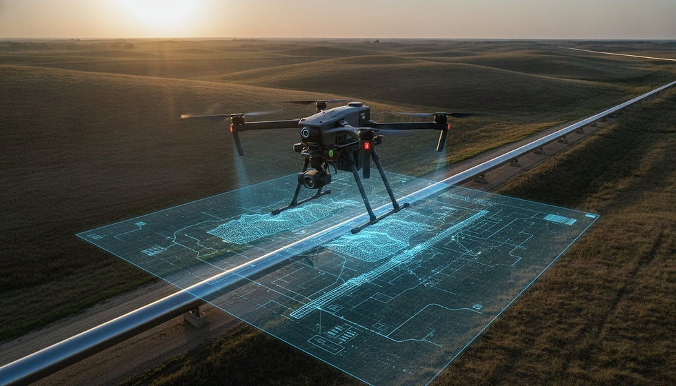
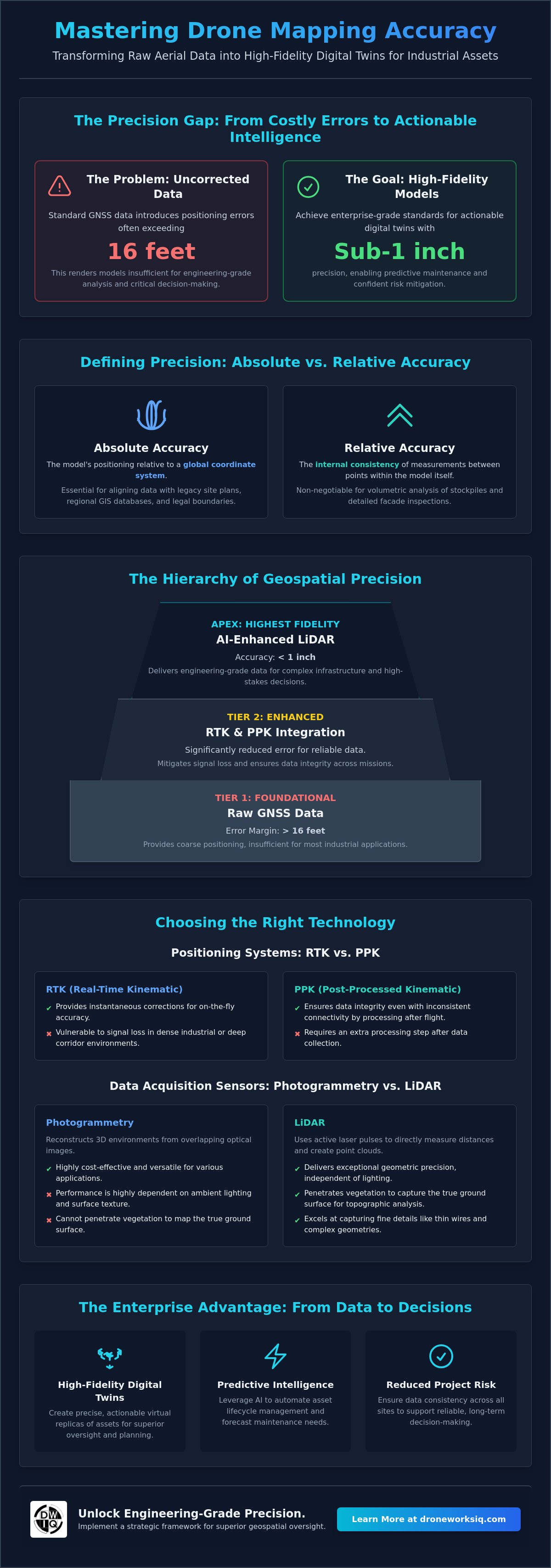
The assumption that high-resolution imagery equates to spatial precision is a costly misconception in industrial asset management. Utilizing uncorrected GNSS data for infrastructure oversight often introduces positioning errors exceeding 16 feet, rendering the resulting models insufficient for engineering-grade analysis. Most technical decision-makers recognize that inconsistent data quality across flight missions remains a primary barrier to generating actionable intelligence. Establishing rigorous drone mapping accuracy enterprise standards is the only viable path to transforming raw aerial data into high-fidelity digital twins that support predictive maintenance and risk mitigation.
This article outlines a strategic framework designed to master the technical and operational variables that define enterprise-grade mapping. The analysis details the ROI complexities of LiDAR versus photogrammetry while ensuring compliance with current NDAA procurement regulations. The following sections examine the deployment of advanced systems like the Skydio X10D and the integration of AI-driven analytics. This methodical approach provides the protocols necessary to deliver precise, standardized data across national assets, reducing project risk and optimizing long-term infrastructure ROI through superior geospatial oversight.
Key Takeaways
Differentiate between absolute and relative spatial accuracy to achieve the sub-1 inch precision required for high-stakes volumetric and facade inspections.
Evaluate the technical performance trade-offs between RTK, PPK, and LiDAR sensors to identify the most efficient data collection method for complex industrial sites.
Standardize data collection protocols to ensure consistent drone mapping accuracy enterprise wide, reducing project risk through high-fidelity digital twins.
Leverage AI-driven geospatial analytics to transform high-fidelity aerial data into predictive intelligence for automated asset lifecycle management.
Implement a strategic framework that optimizes Ground Sampling Distance and flight parameters to maintain data integrity across diverse environmental conditions.

Defining Precision: Absolute vs. Relative Accuracy in Enterprise Geospatial Data
Spatial precision in industrial applications is bifurcated into two distinct metrics: relative and absolute accuracy. Relative accuracy refers to the internal consistency of a digital twin, measuring the distance between points within the model itself. In contrast, absolute accuracy defines the model's positioning relative to a global coordinate system. High-performance unmanned aerial photogrammetric survey methodologies prioritize these metrics based on the project's specific operational requirements. Sub-1 inch relative accuracy is non-negotiable for volumetric analysis in stockpiles or detailed facade inspections, where precise measurements of structural defects determine maintenance cycles.
Achieving high drone mapping accuracy enterprise standards requires rigorous ground-truthing to ensure data fidelity. Absolute accuracy becomes the primary driver when aerial data must align with legacy site plans or regional GIS databases. It's especially critical for uav land surveying and legal boundary verification. Without absolute positioning, digital twins exist in a spatial vacuum. This makes it impossible to overlay multi-temporal datasets for erosion monitoring or utility alignment. Data that lacks global context cannot support the long-term predictive analytics required for national asset management.
Key Takeaways for Enterprise Decision-Makers
Accuracy requirements must be dictated by the specific industrial application, distinguishing between 6 in tolerances for general site progress and 1 in tolerances for engineering-grade analysis.
Data consistency across national assets is more valuable than isolated high-precision missions; a standardized protocol ensures reliable intelligence at scale.
Technical Determinants of Mapping Reliability: RTK, PPK, and LiDAR Integration
Operational reliability in drone mapping accuracy enterprise workflows depends on the selection of high-precision positioning systems. Real-Time Kinematic (RTK) technology provides instantaneous corrections through a constant telemetry link between the aircraft and a base station or NTRIP network. While efficient, RTK is vulnerable to signal attenuation in dense industrial environments or deep utility corridors. Post-Processed Kinematic (PPK) mitigates this risk by recording raw GNSS data for subsequent processing, ensuring data integrity even in areas with inconsistent connectivity. The decision between these methodologies often hinges on the practicality and accuracy of UAS deployments within specific RF-congested zones.
Data acquisition sensors represent the second pillar of mapping fidelity. Photogrammetry utilizes passive optical sensors to reconstruct 3D environments through triangulation, a process highly dependent on lighting and surface texture. Conversely, LiDAR employs active laser pulses to measure distances directly, creating dense point clouds with exceptional geometric precision. LiDAR point cloud density serves as the primary metric for evaluating the fidelity of infrastructure asset inspections. To achieve the highest level of detail for critical projects, specialized LiDAR Data Collection and Analysis services are required to generate high-fidelity digital twins.
The LiDAR Advantage in Complex Infrastructure Environments
LiDAR systems offer a distinct advantage in environments with heavy canopy cover or complex vertical geometries. Unlike photogrammetry, which only captures the uppermost visible layer, multi-return LiDAR pulses penetrate vegetation to identify the true ground surface. This capability is essential for erosion monitoring and topographic analysis in overgrown utility easements. Active sensors also excel in facade inspections, where they capture fine structural details and thin wires that photogrammetric algorithms frequently misinterpret as noise. For specialized energy infrastructure, you can learn more about Drone Tech Aerospace and their technical standards for wind turbine inspections.
Validation Protocols: GCPs and Checkpoints
Absolute data fidelity is maintained through the strategic integration of Ground Control Points (GCPs) and independent checkpoints. GCPs act as the physical anchors for the digital model, tying aerial data to surveyed coordinates with sub-1 inch precision. However, relying solely on GCPs for model generation can introduce mathematical bias. Independent checkpoints, which are not used in the processing phase, are vital for validating the final output. These checkpoints provide an objective assessment of the model's accuracy, ensuring that the resulting geospatial intelligence meets the stringent requirements of engineering and legal verification.
Operational Variables and Environmental Constraints on Data Fidelity
Data fidelity in high-stakes industrial environments is not solely a function of hardware. It's an outcome of rigorous operational parameterization. Flight altitude directly dictates the spatial resolution of the resulting dataset. Achieving a 2 in horizontal accuracy at a 400 ft altitude requires a precise calibration of sensor pitch and aircraft velocity. Autonomous aerial data collection is the primary mechanism for eliminating the stochastic errors associated with manual piloting. This systematic approach ensures that drone mapping accuracy enterprise requirements are met with mathematical consistency across diverse site conditions.
Optimizing Ground Sampling Distance (GSD)
Ground Sampling Distance represents the physical distance between two consecutive pixel centers on the ground. A flight at 200 ft altitude yields a significantly higher GSD than one at 400 ft. This level of detail is essential for specialized Facade Inspection Services where sub-inch crack detection is required. Conversely, broad-scale Erosion Monitoring Services may prioritize wider coverage at a higher altitude, accepting a coarser GSD to optimize flight duration. The strategic selection of altitude must balance the need for granular detail against the operational efficiency required for large-scale asset oversight.
Mitigating Environmental Signal Degradation
Environmental stressors frequently compromise data integrity in industrial zones. Signal interference from high-voltage utility lines or the multipath effects found in "urban canyons" can degrade GNSS positioning. Maintaining a reliable lock requires the deployment of redundant inertial measurement unit (IMU) systems that synchronize with secondary satellite constellations. These systems maintain aircraft orientation during high-velocity data collection, preventing the blurred imagery that results from high wind speeds or rapid light fluctuations. Mastering these variables is critical for maintaining high-level drone mapping accuracy enterprise standards in contested electronic environments. To ensure your assets are monitored with this level of precision, consult our Utility and Pipeline Inspection Services for specialized data acquisition.
Transforming High-Accuracy Data into Actionable Infrastructure Intelligence
High-fidelity spatial data serves as the critical substrate for automated decision-making frameworks. The integration of this intelligence into enterprise asset management systems enables a seamless transition from raw sensor output to strategic industrial oversight. Adhering to rigorous drone mapping accuracy enterprise standards ensures that datasets are not merely visual assets but engineering-grade inputs. This precision allows for the longitudinal tracking of structural integrity across national infrastructure networks, facilitating a shift from reactive repairs to proactive resource allocation.
AI-Driven Feature Extraction and Anomaly Detection
The deployment of AI-driven geospatial analytics represents the next evolution in autonomous infrastructure intelligence. Machine learning algorithms are now capable of processing massive LiDAR datasets to identify structural anomalies that escape human observation. Using data validated to sub-6 in accuracy, these systems automatically detect pipeline leaks, thermal variances, or early-stage erosion. This level of automation reduces the analytical burden on engineering teams and ensures that critical defects are prioritized based on quantified risk metrics rather than subjective assessment.
Strategic Infrastructure Management via Digital Twins
Transitioning from static 2D cartography to high-fidelity 3D digital twins provides a comprehensive virtual record of physical assets. These models support continuous construction progress monitoring and regulatory compliance by providing a high-precision baseline for every site. Our Digital Twinning Services facilitate complex simulations for utility corridor management, reducing operational risk in high-voltage environments. High-resolution 3D replicas allow for millimetric analysis of facade degradation, optimizing long-term maintenance cycles. DroneWorksIQ functions as the strategic partner in this ecosystem, providing the specialized expertise required to interpret complex LiDAR and photogrammetric data for large-scale operations.
Optimizing National Infrastructure Through Precision Geospatial Intelligence
Establishing a high-performance aerial intelligence framework requires the rigorous synthesis of technical positioning, active sensor integration, and standardized operational protocols. Transitioning from raw imagery to engineering-grade digital twins depends on mastering the variables that define drone mapping accuracy enterprise standards. By prioritizing absolute spatial precision and implementing redundant validation through independent checkpoints, organizations can mitigate the risks associated with inconsistent data quality. This methodical approach transforms aerial surveys into a living record of physical assets, capable of supporting complex predictive maintenance cycles.
DroneWorksIQ provides the specialized expertise required to execute high-fidelity data acquisition at scale. Our LiDAR Data Collection and Analysis capabilities ensure that even the most complex industrial environments are captured with sub-inch detail. We combine this technical rigor with AI-driven infrastructure intelligence to automate anomaly detection across national asset portfolios, ensuring that your data remains an actionable strategic asset. Contact DroneWorksIQ for a strategic geospatial consulting session to align your aerial intelligence framework with high-performance industrial standards. Sophisticated geospatial oversight is the foundation of a resilient, data-driven infrastructure future.
Frequently Asked Questions
What is the difference between relative and absolute accuracy in drone mapping?
Relative accuracy measures the positional relationship between objects within a single dataset, whereas absolute accuracy defines the model's position relative to a global geographic coordinate system. High relative accuracy is sufficient for calculating the volume of a localized stockpile. However, absolute accuracy is mandatory when integrating aerial data with regional utility maps or legacy site plans to ensure temporal alignment across multiple mission dates.
How does LiDAR point cloud analysis improve mapping accuracy in dense vegetation?
LiDAR systems utilize active laser pulses that penetrate small gaps in the canopy to reach the ground surface, a capability photogrammetry lacks. By recording multiple returns for each pulse, the system differentiates between the top of the vegetation and the true ground. This allows for the generation of a high-fidelity Digital Terrain Model (DTM) in overgrown utility easements, maintaining drone mapping accuracy enterprise standards where optical sensors would only capture the Digital Surface Model (DSM).
Is RTK or PPK better for large-scale enterprise drone mapping projects?
PPK is generally superior for large-scale enterprise deployments because it eliminates the risk of telemetry link failure between the aircraft and the base station. While RTK offers the benefit of real-time corrections, its dependence on constant radio or cellular connectivity makes it unreliable in remote industrial corridors or RF-congested zones. PPK provides a more robust data recovery workflow, ensuring that the spatial integrity of the final digital twin is maintained without the logistical burden of managing real-time field connections.
Can drone mapping replace traditional land surveying for engineering-grade accuracy?
Drone mapping achieves engineering-grade accuracy when integrated into a hybrid surveying workflow that utilizes a high-precision ground control network. While UAVs don't replace the legal certification of a licensed land surveyor for boundary disputes, they provide a level of data density that traditional methods cannot match. For large-scale infrastructure projects, aerial intelligence offers the most efficient method for generating comprehensive 3D models while maintaining sub-1 inch tolerances when properly ground-truthed.
What environmental factors most significantly impact aerial data collection accuracy?
Solar illumination and atmospheric conditions represent the most significant environmental constraints on data fidelity. For photogrammetry, high-contrast shadows or solar glare can cause feature matching failures, leading to geometric distortions in the point cloud. LiDAR is sensitive to atmospheric moisture and particulate matter, which can attenuate the laser pulse and reduce intensity. Maintaining drone mapping accuracy enterprise requires flight planning that accounts for these variables to ensure the highest possible signal-to-noise ratio during data acquisition.