
Drone Inspection Reporting Services: An Enterprise Framework for Geospatial Intelligence
- Dan

- 4 days ago
- 9 min read
Professional drone reporting is not a collection of images; it is a structured geospatial intelligence product that transforms raw sensor data into autonomous infrastructure insights. Current enterprise operations frequently suffer from data silos that prevent integration with existing asset management software, resulting in low-fidelity reporting that lacks necessary sub-inch accuracy. Manual data interpretation remains a primary source of human error and elevated risk within these fragmented workflows. To achieve operational excellence, drone inspection reporting services must transition toward a centralized framework that prioritizes high-precision data acquisition and technical clarity.
This technical guide establishes a rigorous framework for the essential components, data structures, and AI-driven analytics required to modernize infrastructure oversight. It details the implementation of automated anomaly detection and the generation of high-resolution digital twins for longitudinal asset monitoring. We provide a methodical breakdown of structured reporting templates designed to facilitate strategic decision-making and ensure geospatial data serves as a reliable foundation for industrial intelligence.
Key Takeaways
Transitioning from qualitative visual assessments to quantitative geospatial intelligence requires drone inspection reporting services that deliver sub-inch accuracy for enterprise-grade decision-making.
High-fidelity inspection reports leverage LiDAR point cloud analysis and AI-driven detection to automate the identification of structural defects with 1-inch geometric precision.
Strategic interoperability is achieved by exporting processed geospatial data directly into existing BIM, GIS, and EAM platforms to eliminate data silos.
Temporal data analysis facilitates long-term asset monitoring; it allows for precise erosion tracking and infrastructure health assessments through historical data comparisons.
Effective partner selection depends on a rigorous evaluation of data processing speeds and the alignment of hardware capabilities with specific analytical requirements.
Defining the Enterprise Standard for Drone Inspection Geospatial Intelligence Reporting
Modern infrastructure management requires a transition from subjective visual interpretations to rigorous, quantitative geospatial intelligence. Legacy inspection methods often rely on qualitative photography, which lacks the spatial context necessary for predictive maintenance or structural modeling. Enterprise-grade drone inspection reporting services provide the technical architecture required to convert raw sensor outputs into verifiable engineering data. This shift enables stakeholders to move beyond simply viewing a defect to measuring its exact dimensions and rate of deterioration. Precision is the new baseline. High-performance frameworks now mandate that every data point is georeferenced and repeatable across longitudinal studies.
Key Takeaway: Enterprise reporting must provide sub-inch accuracy and autonomous anomaly detection.
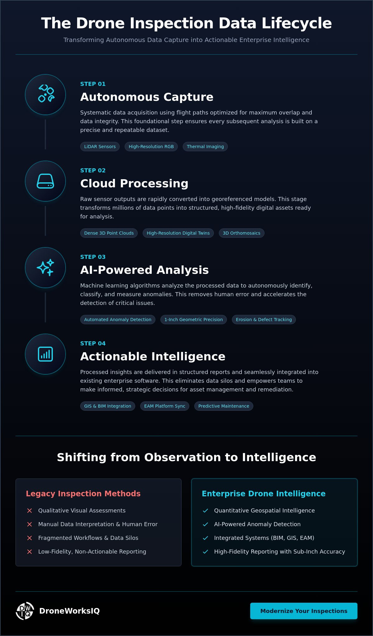
Infographic: The Data Lifecycle — From Autonomous Capture to Actionable Intelligence
Autonomous Capture: Systematic data acquisition via LiDAR and high-resolution sensors using flight paths optimized for overlap.
Cloud Processing: Rapid conversion of raw sensor outputs into georeferenced point clouds and 3D orthomosaics.
AI Analysis: Algorithmic identification of structural anomalies, thermal gradients, or erosion patterns.
Actionable Intelligence: Seamless integration of processed insights into enterprise asset management (EAM) systems for immediate remediation.
High-fidelity oversight is contingent upon the strategic deployment of LiDAR and photogrammetry. While photogrammetry excels in surface texture and visual reconstruction, LiDAR provides direct geometric measurements that are essential for drone applications in infrastructure inspections. These technologies ensure that every digital twin or report maintains a rigorous spatial relationship to the physical asset. It's no longer sufficient to provide a gallery of images; the data must be actionable and spatially accurate.
The Shift to Multi-Sensor Data Fusion
Relying solely on RGB sensors creates critical blind spots in asset assessments. Effective infrastructure digital twins require the integration of thermal data for identifying heat signatures in utilities, LiDAR for measuring structural deflection, and high-resolution imagery for surface analysis. Data fusion is the algorithmic synchronization of multiple sensor datasets into a single, cohesive geospatial model that provides a comprehensive digital representation of physical asset health. This approach eliminates data silos and provides a unified view of complex infrastructure.
Regulatory and Compliance Reporting Requirements
Compliance remains a non-negotiable pillar of enterprise operations. Reporting frameworks must align with FAA Part 107 standards and strict Remote ID enforcement protocols to ensure legal flight operations. Within national utility corridors and urban environments, documentation must meet specific safety and privacy standards. This includes maintaining precise logs for facade inspections and construction site compliance to mitigate liability and ensure long-term operational viability. Professional reports act as a legal record of due diligence.
Critical Components of High-Fidelity Inspection Reports
Enterprise-grade drone inspection reporting services depend on the integration of high-resolution sensor data and rigorous spatial metadata. Every data point within a professional report must be mapped to precise georeferenced coordinates to ensure longitudinal consistency and repeatability. This precision allows for the transition from visual documentation to engineering-grade analysis. High-fidelity reports facilitate a 1-inch geometric accuracy via LiDAR point cloud analysis, which is essential for identifying subtle structural shifts or material degradation that visual inspections might overlook. These datasets serve as the authoritative record for infrastructure health, providing a level of detail that aligns with FHWA Drone Inspection Resources for transportation and civil engineering standards.
LiDAR and Photogrammetry Data Modules
The creation of infrastructure digital twins requires the conversion of raw LiDAR sensor outputs into dense 3D point clouds. This process enables the generation of topographical maps and highly accurate volumetric measurements. For instance, utilizing a stockpile volume measurement drone methodology provides construction intelligence that is far superior to traditional manual surveying. These 3D modules allow stakeholders to interact with a digital representation of the asset, performing virtual measurements and structural assessments within a simulated environment. The resulting models provide the geometric foundation for complex asset management workflows.
AI Analytics and Automated Feature Extraction
Processing massive geospatial datasets requires the implementation of machine learning algorithms to maintain operational efficiency. AI-driven systems automate the identification of defects across expansive facade surfaces and national pipeline corridors. By leveraging AI-driven geospatial analytics, organizations can extract actionable features from raw imagery without the risk of human fatigue or oversight. This automated feature extraction transforms thousands of high-resolution images into a prioritized list of maintenance requirements, a hallmark of sophisticated drone inspection reporting services. Technical decision-makers can utilize these insights to optimize resource allocation and mitigate structural risks before they escalate into critical failures. To enhance your facility oversight, consider integrating advanced digital twinning services into your standard maintenance protocol.
Integrating Geospatial Intelligence into Asset Management
The true utility of drone inspection reporting services lies in their seamless interoperability with established Enterprise Asset Management (EAM), Building Information Modeling (BIM), and Geographic Information Systems (GIS) platforms. Data silos represent a significant operational risk; therefore, raw geospatial outputs must be converted into standardized, machine-readable formats. This integration transforms a standalone inspection report into a dynamic data stream that feeds directly into maintenance scheduling and structural health monitoring. Organizations leveraging these protocols achieve a higher degree of strategic oversight by centralizing disparate data points into a unified source of truth.
Autonomous aerial data collection significantly reduces personnel risk by eliminating the need for manual climbing or hazardous equipment deployment. This paradigm shift is evident in recent State Government Drone Adoption initiatives, where agencies have successfully integrated unmanned systems into bridge and survey workflows to enhance safety. By standardizing these protocols, enterprises ensure that data acquisition is both repeatable and compliant with rigorous safety mandates. Professional data handling moves the report from a simple visual aid to a critical component of the asset’s lifecycle documentation.
Progress Monitoring and Temporal Benchmarking
Standardizing reporting intervals is critical for maintaining a granular record of site evolution. Implementing a framework for aerial construction progress monitoring allows project managers to quantify site changes through comparative volumetric and terrain analysis. These temporal benchmarks provide the empirical evidence required to validate contractor performance and identify schedule deviations with high precision. By comparing historical point clouds, stakeholders can detect subtle shifts in topography or material stockpiles that indicate potential erosion or logistical inefficiencies.
Geospatial Consulting for Strategic Oversight
Converting complex AI-driven data into executive-level intelligence requires specialized geospatial consulting. Professional interpretation ensures that identified anomalies are contextualized within the broader infrastructure lifecycle, informing long-term Capital Expenditure (CapEx) planning. This strategic layer of analysis moves organizations beyond reactive maintenance toward a model of predictive resilience. For comprehensive infrastructure oversight, organizations should utilize professional Digital Twinning Services to maintain a persistent, high-fidelity record of asset health across their entire portfolio.
Selecting an Enterprise Drone Inspection Partner
Rigorous selection of an enterprise partner for drone inspection reporting services requires a technical evaluation of sensor integration and data processing throughput. Hardware capabilities are not interchangeable; the choice between LiDAR and high-resolution photogrammetry must align with the specific geometric requirements of the target infrastructure. LiDAR remains essential for complex assets requiring sub-inch precision, whereas photogrammetry serves as the standard for high-fidelity surface texture analysis. Operational efficiency is dictated by data processing speed and the accuracy of AI-driven analytical outputs. Any latency in data delivery or inaccuracy in anomaly detection translates directly into increased operational risk and deferred maintenance costs.
Technical Credential Verification
Technical decision-makers must audit a provider's ability to deliver consistent sub-inch precision across diverse environmental conditions. Verification protocols should focus on the reliability of AI-driven feature extraction to ensure that structural defects are identified with repeatable accuracy. A partner's data architecture must support the transition from raw sensor outputs to georeferenced engineering data without compromising spatial integrity. This methodical approach to validation ensures that the resulting geospatial intelligence is a reliable foundation for long-term asset management.
Scalability and National Service Deployment
Enterprise operations demand standardized reporting across expansive national utility or pipeline networks. Scalability depends on the deployment of autonomous aerial solutions that maintain rigorous data standards regardless of geographic location. Regulatory compliance is a non-negotiable prerequisite. Partners must demonstrate full FAA Remote ID compliance, which has been strictly enforced since early 2024. With the FAA expected to finalize Part 108 regulations for Beyond Visual Line of Sight (BVLOS) operations in mid-2026, the capacity to execute long-range, autonomous inspections will become a critical differentiator for high-performance service providers.
The Total Cost of Ownership (TCO) of high-fidelity aerial data is justified by the significant Return on Investment (ROI) derived from predictive maintenance. High-resolution data reduces capital expenditure by identifying structural degradation before it necessitates total asset replacement. A sophisticated partner provides the framework required to transform raw imagery into a permanent digital record. This lifecycle documentation ensures that geospatial intelligence remains a strategic asset throughout the infrastructure's operational life. Organizations seeking to modernize their oversight should prioritize partners who offer integrated LiDAR Data Collection and Analysis to ensure the highest level of geometric certainty.
Advancing Infrastructure Resilience through Geospatial Intelligence
The transition toward a unified geospatial framework is mandatory for organizations managing high-value infrastructure assets. Modern drone inspection reporting services provide the technical architecture required to pivot from qualitative assessments to quantitative, engineering-grade oversight. By leveraging sub-inch LiDAR precision and AI-driven analytics, enterprises can eliminate data silos and ensure seamless interoperability with existing asset management platforms. This structured methodology facilitates high-fidelity digital twin generation and provides the longitudinal data necessary for strategic capital planning. It's the most efficient path toward mitigating structural risk while maintaining rigorous compliance across national utility and pipeline networks.
DroneWorksIQ offers the specialized expertise and autonomous systems required to transform raw sensor data into actionable industrial intelligence. Our focus on precision and national infrastructure inspection expertise ensures that every data point contributes to a comprehensive and repeatable record of asset health. Contact DroneWorksIQ for Enterprise Aerial Intelligence Solutions to optimize your infrastructure monitoring protocols today. Superior data is the primary catalyst for a more resilient and secure industrial future.
Frequently Asked Questions
What should be included in a standard drone inspection report for infrastructure?
A standard infrastructure report must contain georeferenced orthomosaics, 3D point clouds, and a prioritized list of structural anomalies. These reports integrate multispectral imagery and thermal data to identify subsurface defects or heat signatures. Every identified anomaly includes precise coordinates and high-resolution visual evidence to facilitate immediate remediation. This structured approach ensures that drone inspection reporting services provide a comprehensive digital record suitable for engineering-grade analysis and long-term asset management.
How accurate are drone-based LiDAR inspection reporting services?
Drone-based LiDAR systems achieve sub-inch geometric accuracy, typically providing 1-inch precision for structural measurements and topographical mapping. This high level of fidelity is maintained through the use of advanced Inertial Measurement Units and Real-Time Kinematic positioning. Such precision is essential for detecting subtle structural deflections or erosion patterns that visual-only assessments might miss. Professional reporting frameworks ensure these measurements are repeatable and verifiable across multiple inspection cycles.
Can drone inspection data be integrated into existing GIS or BIM software?
Aerial geospatial data is fully interoperable with standard BIM, GIS, and Enterprise Asset Management platforms. Processing workflows convert raw sensor outputs into industry-standard formats such as LAS for point clouds and GeoTIFF for orthomosaics. This compatibility allows for the seamless ingestion of digital twins into existing software environments for centralized oversight. Standardizing these data streams eliminates information silos and enables stakeholders to visualize infrastructure health within their primary operational dashboard.
What is the difference between visual drone reporting and LiDAR-based reporting?
Visual reporting relies on RGB sensors to capture surface-level imagery, whereas LiDAR-based reporting utilizes active laser sensing to penetrate vegetation and capture precise 3D geometry. While visual data excels at identifying surface defects like cracks or corrosion, LiDAR provides the structural measurements necessary for volumetric analysis and digital twinning. Combining both sensor types through multi-sensor data fusion creates the most comprehensive infrastructure report, linking high-resolution visual evidence with exacting spatial accuracy.
How does AI improve the speed of drone inspection reporting?
AI improves reporting velocity by automating the identification of anomalies across massive geospatial datasets. Machine learning algorithms process thousands of high-resolution images to extract features such as structural cracks, pipeline leaks, or erosion zones without human intervention. This automated feature extraction reduces data processing times from weeks to days, allowing technical teams to focus on strategic remediation rather than manual data review. AI-driven analytics ensure that critical defects are prioritized with methodical accuracy.


