
Drone Pipeline Inspection Services: Enterprise Data & Analytics Guide (2026)
- Dan

- 4 days ago
- 8 min read
The global market for drones in pipeline inspection reached $1,223 million in 2025, signaling a definitive industry pivot toward automated infrastructure oversight. Legacy manual Right-of-Way patrols generate excessive operational expenditures and introduce unnecessary safety risks while producing delayed intelligence that inhibits proactive asset management. Enterprise decision-makers increasingly find that traditional ground-based observation fails to provide the high-frequency, high-fidelity data required for modern industrial resilience.
This guide establishes a technical roadmap for leveraging drone pipeline inspection services to optimize pipeline integrity and ensure comprehensive regulatory compliance. Through the deployment of autonomous aerial intelligence and advanced LiDAR sensors, operators can achieve sub-6 inch accuracy for terrain shift monitoring and reduce inspection costs by 30% to 50%. We'll examine the integration of digital twin platforms and the utilization of AI-driven analytics to facilitate predictive maintenance. This analysis covers the strategic application of Beyond Visual Line of Sight operations under the FAA’s Part 108 framework to eliminate data lag and transform raw geospatial captures into actionable enterprise intelligence.
Key Takeaways
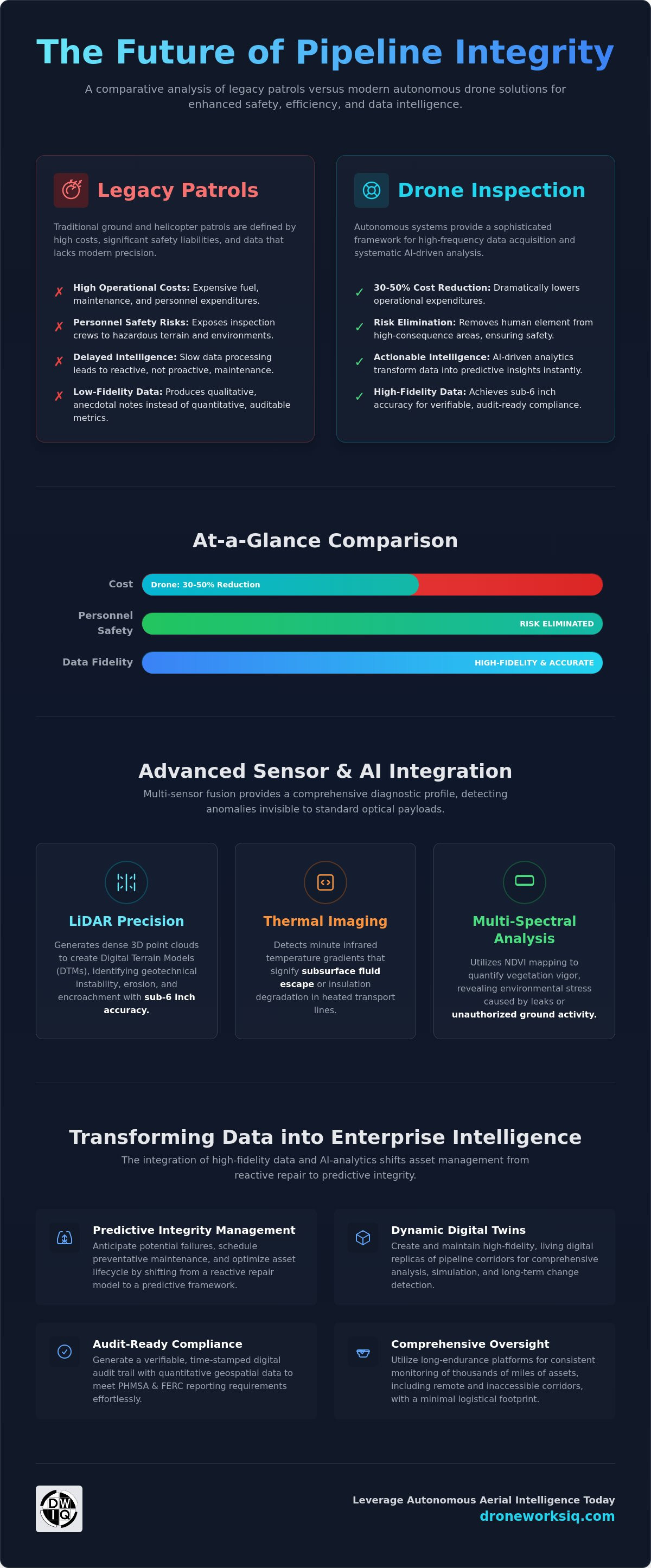
Transitioning to autonomous drone pipeline inspection services facilitates a 30% to 50% reduction in operational expenditures while eliminating personnel exposure to hazardous environments.
Advanced LiDAR integration provides sub-6 in accuracy for terrain shift monitoring, establishing a high-fidelity baseline for geotechnical stability and regulatory compliance.
Multi-sensor fusion, encompassing thermal and multi-spectral analysis, identifies subsurface leak signatures and insulation degradation invisible to standard optical payloads.
The integration of AI-driven geospatial analytics enables the creation of dynamic digital twins, shifting asset management from reactive repair to predictive integrity.
The Paradigm Shift: Drone Pipeline Inspection Services for Pipeline Integrity
Modern industrial oversight has transitioned from qualitative observation to quantitative intelligence. Traditional helicopter patrols, while historically standard for monitoring pipeline transport systems, introduce high operational costs and significant safety liabilities. Legacy methodologies frequently produce low-resolution datasets that lack the precision required for modern predictive modeling. It's a technological evolution where drone pipeline inspection services represent a sophisticated integration of autonomous aerial acquisition and systematic AI synthesis. This framework facilitates the transformation of raw geospatial captures into multi-dimensional asset intelligence, providing a granular view of infrastructure health that was previously unattainable.
Key Takeaway: The transition to autonomous UAV systems replaces subjective manual patrols with a high-fidelity, data-driven framework that enhances safety and ensures audit-ready compliance through quantitative geospatial analysis.

Mitigating Operational Risks in Hazardous Corridors
Remote or high-consequence areas present logistical challenges that compromise personnel safety. Autonomous systems navigate these hazardous corridors without putting human inspectors at risk, maintaining consistent flight paths across thousands of miles of assets. It's critical for monitoring erosion in steep terrain or detecting encroachment in restricted zones where ground access is limited. By utilizing long-endurance platforms, operators maintain comprehensive oversight of sprawling networks with a minimal logistical footprint. This approach effectively removes the human element from high-risk environments while increasing data frequency.
Regulatory Compliance and Audit Integration
Compliance frameworks established by PHMSA and FERC necessitate verifiable, time-stamped proof of integrity. Drone pipeline inspection services deliver a digital audit trail that replaces anecdotal field notes with precise, repeatable data sets. It's a transition to quantitative geospatial data that ensures every inspection is backed by high-resolution imagery and sensor readings. Such documentation facilitates rapid response during audits and provides a defensible record of proactive maintenance, streamlining the path toward continuous regulatory adherence and long-term asset viability.
Technical Modalities: LiDAR, Thermal, and Multi-Spectral Analysis
Effective infrastructure integrity management requires the transition from simple optical capture to multi-sensor fusion. The integration of innovative remote sensing technologies into standardized Right-of-Way (ROW) maintenance protocols allows for the detection of subtle anomalies that precede catastrophic failure. While high-resolution photogrammetry provides visual context, drone pipeline inspection services rely on specialized payloads to quantify subsurface and geotechnical variables. These modalities provide a comprehensive diagnostic profile, distinguishing between surface-level vegetation encroachment and structural integrity threats like soil subsidence or fluid escape. The data doesn't just provide imagery; it provides high-fidelity intelligence for strategic decision-making.
LiDAR Precision for Terrain and Encroachment
LiDAR systems utilize high-frequency laser pulses to generate dense 3D point clouds, enabling the creation of Digital Terrain Models (DTM) even through dense canopy. This technology is essential for identifying geotechnical instability and slope failure along pipeline corridors. Modern sensors achieve the precision necessary to detect elevation shifts as small as 6 in, providing an early warning system for soil movement that could stress the pipeline structure. By comparing temporal datasets, engineers can track erosion patterns and quantify encroachment with millimeter-level relative accuracy. For assets in complex topographies, utilizing professional LiDAR Data Collection and Analysis ensures that terrain shifts are identified before they compromise asset safety.
Thermal and Multi-Spectral Leak Detection
Thermal sensors detect infrared radiation to identify localized temperature gradients that deviate from the ambient baseline. These anomalies often indicate subsurface fluid escape or insulation degradation in heated transport lines. Multi-spectral analysis complements this by monitoring the biological response of the surrounding ecosystem. NDVI mapping utilizes multi-spectral imagery to quantify vegetation vigor along the Right-of-Way, facilitating the identification of environmental stress or unauthorized ground activity. While LiDAR addresses mechanical and geotechnical risks, thermal and multi-spectral sensors focus on containment integrity and environmental impact. This dual-sensor approach ensures that even small-scale leaks are identified through their thermal signatures or their effect on local flora.
Operational Framework: From Autonomous Acquisition to AI Synthesis
The systematic conversion of raw aerial data into actionable intelligence requires a rigorous operational framework. Unlike manual flight operations that rely on pilot intuition, modern drone pipeline inspection services utilize standardized, pre-programmed mission parameters. This methodology ensures repeatable data quality across expansive networks. It facilitates the cost-effective maintenance of oil and gas pipelines by minimizing human error and logistical delays. The resulting data stream undergoes multi-stage processing where raw point clouds and imagery are ingested into secure, cloud-based environments for synthesis. It's paramount that this workflow remains seamless. Protecting the integrity of sensitive infrastructure data is as critical as the physical asset, necessitating advanced encryption and strict data residency protocols for national utility assets.
Autonomous Data Acquisition Protocols
Precision in data collection is achieved through the transition from manual control to fully autonomous flight paths. These systems utilize advanced inertial navigation to maintain operational reliability in remote environments where GPS signals may be intermittent or unavailable. Automation drives efficiency. Autonomous UAVs follow high-fidelity flight corridors, ensuring consistent sensor orientation and overlap for superior photogrammetric and LiDAR reconstruction. It's fundamental for temporal analysis, where current scans must be precisely aligned with historical baselines to detect minute structural changes over time.
AI-Driven Feature Extraction and Analysis
The core of the intelligence layer for drone pipeline inspection services is AI-driven geospatial analytics, which automates the identification of structural and environmental anomalies. Machine learning algorithms process massive datasets to detect surface corrosion, mechanical deformation, or unauthorized construction activity within the Right-of-Way. This automated feature extraction reduces the latency between acquisition and intervention. It allows for rapid response to critical threats. Strategic asset management relies on professional geospatial consulting to interpret these complex LiDAR outputs, ensuring that technical data translates into prioritized maintenance schedules. Precision remains the priority. To implement these advanced workflows, organizations should utilize specialized Utility and Pipeline Inspection Services that integrate end-to-end data security and analytical precision.
Strategic Asset Management: Digital Twins and Predictive Integrity
The ultimate objective of drone pipeline inspection services is the creation and maintenance of a high-fidelity digital twin. This virtual replica serves as a permanent, multi-dimensional record of physical infrastructure, updated through periodic autonomous scans. These models provide engineers with a platform for simulating "what-if" scenarios, ranging from disaster response modeling to complex expansion planning. By visualizing the asset in a risk-free digital environment, stakeholders identify potential bottlenecks or structural vulnerabilities without disrupting active operations. It's a transition from viewing data as a static report to utilizing it as a dynamic management tool.
High-Fidelity 3D Modeling and Virtual Inspections
Advanced photogrammetry transforms thousands of high-resolution images into immersive 3D environments. These models allow for remote engineering reviews that eliminate the need for costly and hazardous site visits. The integration of 5 ft 11 in resolution models into existing enterprise GIS frameworks ensures that geospatial data remains accessible across all departments. This spatial precision allows for the exact positioning of components and terrain features within the virtual space, facilitating highly accurate virtual inspections. Utilizing professional Drone Mapping and Photogrammetry Services ensures that these digital assets meet the technical requirements for industrial-grade analysis.
Predictive Maintenance and ROI Frameworks
Transitioning from reactive repair strategies to a predictive maintenance model represents a significant shift in asset management economics. Quantifying the return on investment involves comparing the high costs of emergency repairs and environmental remediation against the surgical precision of early anomaly detection. Autonomous monitoring identifies minor degradations before they escalate into structural failures. A unified geospatial data platform provides executive decision-makers with a comprehensive overview of network health, allowing for optimized capital allocation. Long-term operational resilience for national utilities depends on a consistent aerial intelligence partnership that provides the technical depth required for multi-year integrity planning. Organizations should implement comprehensive Digital Twinning Services to bridge the gap between raw data acquisition and strategic infrastructure oversight.
Advancing Industrial Resilience Through Autonomous Oversight
The evolution of industrial infrastructure management necessitates the adoption of high-fidelity, automated systems. Implementing drone pipeline inspection services allows operators to transition from reactive maintenance models to a framework of predictive integrity. This shift is supported by LiDAR data precision within 6 in and AI-driven anomaly detection capable of monitoring thousands of miles of assets with methodical accuracy. These technologies don't just capture imagery; they synthesize complex geospatial variables into actionable intelligence that informs high-stakes decision-making. Total asset transparency is no longer a future objective but an immediate operational requirement for modern energy networks.
National utilities require comprehensive inspection protocols that align with rigorous regulatory standards and minimize human exposure to hazardous environments. By leveraging digital twins and autonomous acquisition, organizations secure long-term asset viability while significantly reducing operational expenditures. It's time to modernize your infrastructure oversight with a partner that operates at the intersection of advanced technology and strategic application. Consult with our geospatial experts on autonomous pipeline intelligence to optimize your integrity management programs. Achieving a resilient, data-driven future starts with precise aerial intelligence.
Frequently Asked Questions
What are the primary benefits of using drones for pipeline inspection over traditional methods?
Drones provide a 50% to 70% reduction in operational costs compared to manned helicopter patrols while significantly enhancing personnel safety. These systems replace qualitative manual observations with high-resolution, quantitative datasets that facilitate predictive maintenance. Removing human inspectors from hazardous corridors eliminates significant liability risks. Autonomous acquisition ensures repeatable data quality across expansive networks, providing a granular level of infrastructure oversight that legacy ground or aerial methods cannot replicate.
How accurate is LiDAR data collection for detecting pipeline ground movement?
LiDAR technology utilized in drone pipeline inspection services achieves vertical and horizontal precision within 6 in for detecting subtle terrain shifts. High-density point clouds allow for the creation of Digital Terrain Models that reveal subsidence or slope instability invisible to the naked eye. By comparing multi-temporal datasets, geospatial analysts identify millimeter-level relative changes in soil elevation. This precision is critical for monitoring geotechnical risks that threaten the structural integrity of buried assets.
Can drones detect subsurface pipeline leaks through thermal imaging?
Thermal sensors identify subsurface pipeline leaks by detecting localized temperature gradients that deviate from the ambient soil baseline. Fluid escape creates a distinct thermal signature on the surface or within the surrounding vegetation. While depth of burial and soil saturation influence detection thresholds, high-sensitivity radiometry identifies anomalies indicating containment failure or insulation degradation. This non-destructive methodology allows for the rapid localization of leaks without the logistical delays associated with traditional ground-based probes.
How do autonomous drone services integrate with existing enterprise GIS platforms?
Autonomous drone data integrates with enterprise GIS platforms through standardized geospatial formats such as GeoTIFFs, LAS point clouds, and vectorized Shapefiles. These outputs facilitate the population of digital twin environments where aerial intelligence is layered over existing asset records. Automated API-driven workflows streamline the ingestion of inspection results into SCADA or Asset Management Systems. This connectivity ensures that field-derived intelligence is immediately accessible to engineering and executive teams for strategic capital allocation.
What regulatory standards govern the use of UAVs for national infrastructure inspection?
Commercial drone operations are governed by FAA Part 107, while the Part 108 framework regulates Beyond Visual Line of Sight (BVLOS) missions for long-linear infrastructure. Compliance with PHMSA and FERC mandates requires verifiable, time-stamped documentation of Right-of-Way integrity. Professional drone pipeline inspection services ensure that all data acquisition adheres to these federal safety and reporting requirements. Utilizing certified operators minimizes legal liability and ensures that inspection records remain audit-ready for national infrastructure oversight.


