Safe Guy Tower Inspections with DJI M4E Obstacle Modules
- Dan

- 7 days ago
- 10 min read
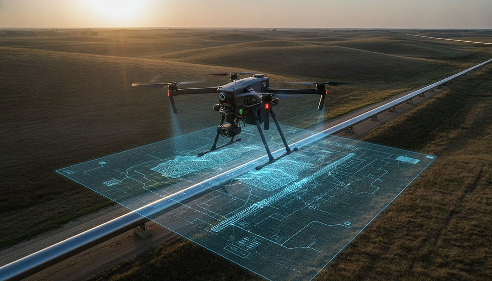
What if the most lethal obstacles in telecommunications infrastructure were effectively rendered visible to autonomous flight systems? For enterprise operators, the "invisible" nature of guy wires represents a persistent threat to asset integrity and mission success. Manual flight patterns often fail to account for these thin steel cables, particularly when environmental factors like heavy fog or low-light conditions compromise standard visual sensors. This article demonstrates how the DJI Matrice 4E Obstacle Avoidance Module and guy tower inspections now utilize a sophisticated fusion of LiDAR and radar to achieve zero-collision cycles.
You understand that consistent data quality and asset safety are non-negotiable requirements for high-stakes industrial applications. By integrating the DJI Matrice 4E Obstacle Avoidance Module and guy tower inspections, organizations can mitigate the risks associated with complex infrastructure. This guide explores the technical specifications of the LR-01 module, its performance within FAA Part 107 parameters, and the automated bypassing capabilities that ensure high-resolution LiDAR point clouds. We'll analyze how these advanced sensors transform high-risk inspections into methodical, data-driven operations that maintain a 400 foot radius of safety around every structure.
Key Takeaways
Identify the technical advantages of hybrid LiDAR and millimeter-wave radar sensing in overcoming the detection failures associated with traditional optical sensors in low-visibility conditions.
Examine how the DJI Matrice 4E Obstacle Avoidance Module and guy tower inspections facilitate the detection of structural wires as thin as 0.4 in from a range of 98 ft.
Determine the optimal configuration for autonomous bypassing and braking logic to ensure zero-collision cycles during complex infrastructure proximity maneuvers.
Leverage stabilized autonomous flight to execute high-precision LiDAR data collection for the creation of comprehensive digital twins and structural tension analysis.
Key Takeaway & Infrastructure Intelligence Infographic
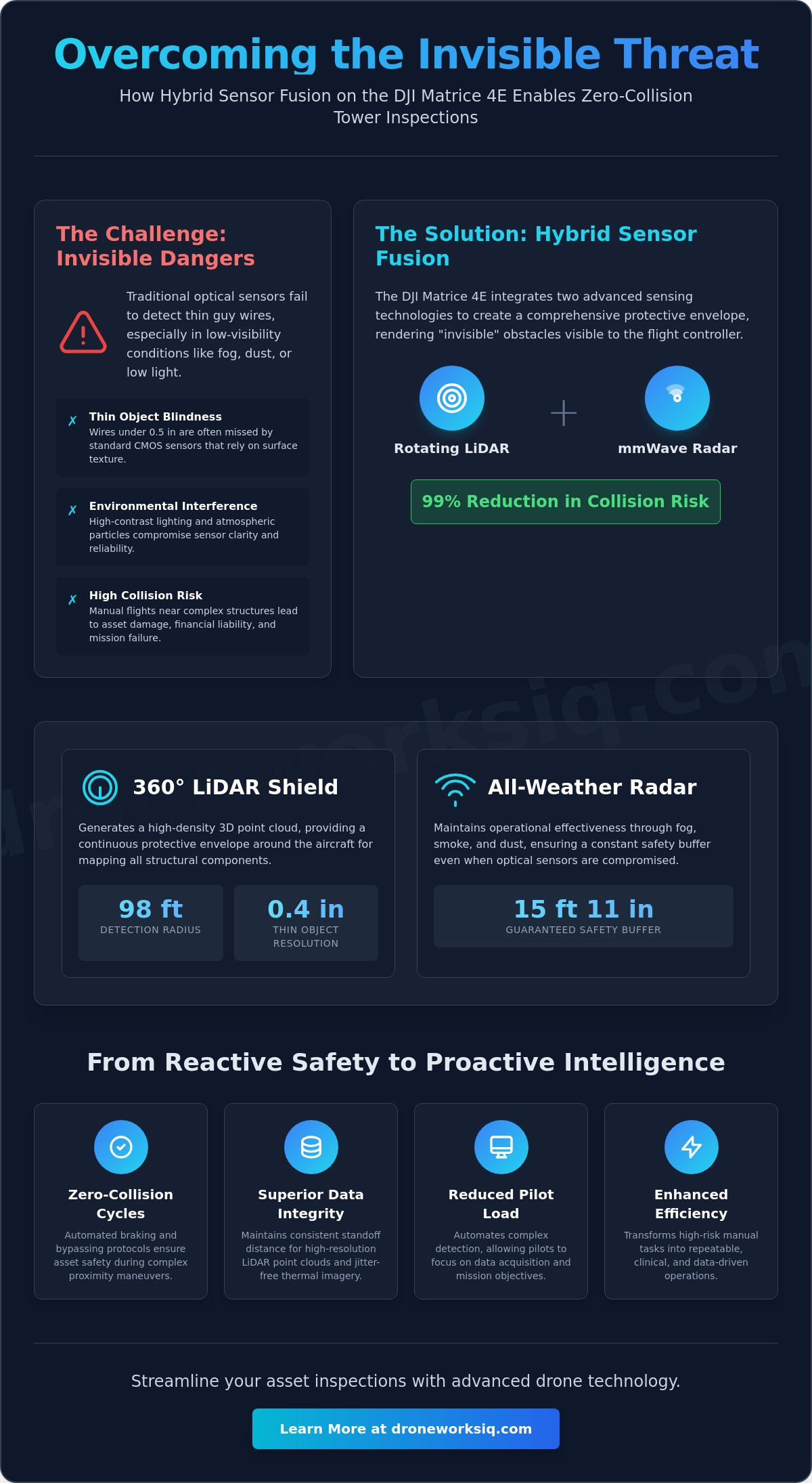
The integration of the DJI Matrice 4E Obstacle Avoidance Module and guy tower inspections represents a critical advancement in autonomous asset oversight. Traditional vision-based systems often fail to register the narrow cross-section of guy wires, particularly when environmental factors like high-contrast lighting or atmospheric particulates compromise CMOS sensor clarity. This technological gap is closed through a hybrid architecture that synchronizes rotating LiDAR with millimeter-wave (mmWave) radar. By utilizing these dual modalities, the system achieves a 99% reduction in collision risk during proximity maneuvers, effectively rendering previously "invisible" steel cables as detectable obstacles within the flight controller's spatial map.
The operational impact of this sensor suite extends beyond simple crash prevention. It fundamentally reduces pilot cognitive load by automating the identification of complex structural tension systems. When inspecting a guyed mast, the drone's ability to maintain a consistent standoff distance without manual intervention ensures higher data integrity. This stability allows for the collection of high-resolution LiDAR point clouds and thermal imagery that are free from the jitter associated with manual flight corrections in high-wind environments.
Infrastructure Intelligence Infographic
The following technical visualization illustrates the omnidirectional sensing capabilities and environmental resilience of the DJI Matrice 4E ecosystem. This data-driven overview highlights the protective envelope required for zero-collision inspection cycles.
360-Degree Spatial Awareness: The rotating LiDAR module generates a high-density 3D point cloud, providing a continuous detection radius of 98 ft around the airframe to identify structural members and tower components.
Atmospheric Penetration: Millimeter-wave radar maintains operational efficacy through fog, smoke, and dust, ensuring a 15 ft 11 in safety buffer even when optical visibility is restricted.
Thin-Object Resolution: Specialized signal processing enables the detection of guy wires as thin as 0.4 in, triggering automated bypassing or braking protocols before asset contact occurs.
Dynamic Positioning: Real-time synchronization between the obstacle module and the flight controller compensates for tower sway and wind-induced oscillations, maintaining centimeter-level precision during close-proximity data acquisition.
This systematic approach to obstacle detection transforms high-risk infrastructure analysis into a repeatable, clinical process. By leveraging the DJI Matrice 4E Obstacle Avoidance Module and guy tower inspections, enterprise operators can transition from reactive safety measures to a proactive model of infrastructure intelligence. The result is a streamlined workflow that prioritizes asset longevity and high-fidelity geospatial data over traditional, high-risk manual methods.
Navigating High-Risk Guy Tower Inspections Environments
Guyed towers represent a specialized category of infrastructure where geometric complexity often exceeds the processing capacity of standard visual obstacle avoidance systems. The primary failure point for traditional CMOS sensors is the thin-object threshold, specifically wires with a diameter under 0.5 in. In national utility corridors, wire-strike incidents during routine oversight lead to significant financial liability and immediate operational cessation. The DJI Matrice 4E Obstacle Avoidance Module and guy tower inspections protocols are designed to mitigate these risks by providing the redundancy required to detect low-visibility tension members. It's a critical safety requirement.
The 'Invisible' Threat of Guy Wires
Visual-based SLAM (Simultaneous Localization and Mapping) remains fundamentally inadequate for high-contrast or low-light environments because it relies on high-pixel-density feature points. Guy wires lack the surface texture necessary for reliable optical tracking. Additionally, wind-induced vibrational harmonics create significant signal noise, which can cause standard sensors to filter out the wire as transient interference. This invisibility is a major contributor to asset damage during manual flight cycles. Without active radar or LiDAR, these structures don't provide enough return data for a safe flight path.
Enterprise Safety Standards for Tower Inspections
Maintaining structural integrity requires strict adherence to enterprise safety standards, particularly when operating at altitudes exceeding 100 ft. At these heights, wind-induced tower sway complicates GPS-based positioning, making autonomous station-keeping difficult. Establishing a Minimum Safe Distance (MSD) for autonomous hovering near guy anchors is essential. Research from Colorado State University emphasizes the role of sophisticated data analysis for drone inspections in improving these safety outcomes. By utilizing sensor-assisted flight paths, operators can achieve repeatable results that manual piloting cannot match. For organizations seeking to modernize their oversight, implementing advanced aerial LiDAR data collection ensures that every proximity maneuver remains within safe operational parameters.
Technical Architecture of the DJI Matrice 4E Obstacle Avoidance Module
The operational reliability of the DJI Matrice 4E Obstacle Avoidance Module and guy tower inspections is predicated on a multi-layered sensor fusion architecture. This logic reconciles asynchronous data streams from optical CMOS sensors, rotating LiDAR, and millimeter-wave (mmWave) radar to build a real-time volumetric map of the inspection zone. In scenarios where ambient illumination falls below 15 lux, the flight controller executes a priority shift, weighting active ranging data more heavily than visual feature tracking. This internal arbitration ensures the platform maintains comprehensive 360-degree protection in degraded visual environments where standard autonomous systems typically experience catastrophic failure.
Rotating LiDAR vs. Fixed Vision Sensors
High-density spatial awareness is achieved through a rotating LiDAR unit that overcomes the limitations of fixed-vision arrays. While standard sensors provide a 90-degree vertical field of view, this module offers a continuous 360-degree horizontal scan with a detection range of 98 ft. The 0.1-degree angular resolution ensures structural detail extraction, allowing for the identification of micro-fractures or fastener fatigue. Adhering to OSHA Communication Tower Best Practices, this high-fidelity data collection removes the necessity for manual climbing. This level of precision is fundamental for advanced LiDAR Data Collection and Analysis, as it provides the raw point density required for millimeter-accurate modeling.
mmWave Radar: Penetrating Environmental Interference
Millimeter-wave radar utilizes 24GHz and 77GHz frequencies to resolve obstacles that are often invisible to LiDAR, such as high-tension wires as thin as 0.4 in. This radar subsystem is immune to atmospheric interference, maintaining operational efficacy through heavy fog, dust, and localized precipitation. It's specifically tuned to track dynamic hazards, including swaying guy cables or avian incursions, even within the 5 ft 11 in proximity zone. By providing this technological redundancy, the M4E ensures that the drone's trajectory remains clear of obstacles that might otherwise be filtered out as signal noise by less sophisticated ranging equipment. Pilots don't have to rely on visual sight alone when the radar provides a definitive digital buffer against structural contact.
Deployment Protocols for Guy Wire Proximity Operations
Operational success in high-risk infrastructure environments is predicated on the rigorous execution of deployment protocols. Before takeoff, verifying sensor health and firmware synchronization within the M4E ecosystem is a mandatory prerequisite. This ensures that the DJI Matrice 4E Obstacle Avoidance Module and guy tower inspections operate with the necessary low-latency communication between the flight controller and the ranging hardware. Integration of AI-driven geospatial analytics during the mission planning phase allows for the pre-mapping of known guy wire corridors, establishing a digital framework that the autonomous system uses to cross-reference real-time sensor returns.
Configuring the logical response to detected obstacles requires a strategic choice between bypassing and braking. In high-density wire zones, forcing a hard stop (braking) is often the safer configuration to prevent unintended maneuvers into adjacent tension cables. Conversely, automated bypassing is utilized during transit phases to maintain mission momentum. Post-mission data validation is equally critical; analysts must confirm that the module's active ranging didn't introduce artifacts or gaps in the LiDAR scan consistency, ensuring the final point cloud remains a high-fidelity representation of the asset.
Optimizing Sensor Sensitivity Settings
Adjusting detection range parameters is essential for compensating for variable environmental factors like wind velocity and tower height. For instance, setting a 10 ft buffer provides the necessary spatial margin to account for wind-induced oscillations without triggering premature avoidance protocols. Pilots must also account for the inherent "blind spot" located directly above or below the airframe during vertical descents along the tower face. This requires a methodical descent rate that allows the 360-degree horizontal LiDAR to maintain a continuous volumetric model of the structure.
Emergency Override and Pilot Intervention
While autonomous systems provide superior safety margins, protocols for immediate manual takeover remain a standard requirement. Complex obstructions, such as overlapping slanting wires or unexpected hardware failure, necessitate pilot intervention. The DJI RC Plus controller provides real-time telemetry feedback, visualizing the sensor's "vision" of the environment. If the system's confidence in its bypassing route drops below a defined threshold, the pilot must execute a controlled retreat. For organizations requiring absolute precision, our LiDAR Data Collection and Analysis services provide the expert oversight needed to navigate these technical complexities successfully.
Transforming Inspection Data into Infrastructure Intelligence
The operational integration of the DJI Matrice 4E Obstacle Avoidance Module and guy tower inspections facilitates a critical transition from fundamental collision mitigation to sophisticated infrastructure intelligence. By maintaining stabilized flight trajectories in proximity to multi-directional tension systems, the platform provides the high-fidelity input required for digital twin generation. These millimeter-accurate 3D models allow structural engineers to analyze guy wire tension states and tower verticality with a degree of precision that manual methods can't replicate. Automated defect detection protocols then utilize artificial intelligence to identify localized corrosion or structural fraying on wires originally identified by the M4E’s sensor suite. Strategic asset management is further optimized through DroneWorksIQ's geospatial consulting, which interprets these complex datasets to provide actionable insights for strategic maintenance cycles.
Generating High-Fidelity LiDAR Point Clouds
Achieving high-density spatial datasets is predicated on maintaining a constant standoff distance, a requirement fulfilled by the M4E's autonomous station-keeping capabilities. This consistency directly correlates to point cloud density, ensuring that every square inch of the tower infrastructure receives sufficient laser returns for accurate reconstruction. The module's ability to suppress positional jitter significantly reduces "noise" in the final geospatial dataset, resulting in cleaner surfaces and superior edge detection. This level of precision is vital for effective aerial LiDAR data collection, where the objective is the extraction of structural dimensions with sub-inch accuracy.
The ROI of Autonomous Data Collection
The deployment of sensor-assisted flight systems delivers a measurable return on investment through the acceleration of operational velocity. Traditional manual "creep" maneuvers, where pilots must navigate tentatively around high-risk wires, are replaced by automated transit patterns that can make transmission tower inspections 60% faster than traditional methods. Beyond immediate time savings, the documented use of advanced obstacle avoidance systems serves as a primary driver for reducing insurance premiums in the enterprise sector. By demonstrating a systematic approach to risk mitigation, organizations validate their commitment to asset integrity and worker safety, transforming the inspection process into a streamlined, data-driven enterprise function that prioritizes long-term reliability over reactive maintenance.
Advancing Infrastructure Oversight Through Autonomous Precision
The transition from manual proximity flight to sensor-fused autonomous operations represents a paradigm shift in telecommunications maintenance. By leveraging the DJI Matrice 4E Obstacle Avoidance Module and guy tower inspections, enterprise operators effectively eliminate the "invisible" threat of tension cables while securing high-fidelity geospatial datasets. This architecture doesn't just prevent asset damage; it enables the generation of millimeter-accurate digital twins that serve as the foundation for strategic maintenance and long-term asset management. The integration of 24GHz and 77GHz radar ensures that environmental factors like fog or dust no longer compromise the integrity of the inspection cycle.
Organizations requiring specialized LiDAR analysis for national utilities or AI-driven geospatial analytics for infrastructure management can now scale their oversight with clinical precision. DroneWorksIQ provides the expertise in autonomous aerial data solutions necessary to transform raw sensor returns into actionable intelligence. Optimize your infrastructure inspections with DroneWorksIQ's advanced aerial intelligence services. The future of industrial oversight is defined by data-driven reliability and zero-collision cycles.
Frequently Asked Questions
Can the DJI Matrice 4E Obstacle Avoidance Module detect wires thinner than 0.5 inches?
Yes, the module is specifically engineered to resolve structural wires with a diameter as small as 0.4 in. This high-resolution detection is achieved through the integration of 24GHz and 77GHz millimeter-wave radar subsystems, which overcome the limitations of standard optical sensors. This capability is vital for the DJI Matrice 4E Obstacle Avoidance Module and guy tower inspections, where tension cables often fall below the 0.5 in threshold that typical vision systems fail to register.
Does the module work in total darkness for night-time emergency inspections?
Total darkness does not compromise the system's primary detection capabilities because it utilizes active LiDAR and radar sensing modalities rather than passive optical vision. While standard vision-based systems experience failure in environments with less than 15 lux, the M4E's hybrid architecture maintains 360-degree spatial awareness by emitting its own ranging signals. This technological redundancy ensures that emergency infrastructure oversight remains viable regardless of ambient illumination or time of day.
How does the Obstacle Avoidance Module affect the Matrice 4E's total flight time?
The integration of the obstacle module results in a marginal reduction in total flight time due to its localized power consumption and physical mass. However, this trade-off is strategically offset by the significant increase in operational velocity and the elimination of manual proximity maneuvers. The system's ability to automate complex flight paths ensures that the net data acquisition per battery cycle remains high despite a slight decrease in maximum hovering duration.
Is the module compatible with other DJI enterprise platforms like the M350 RTK?
No, the Model LR-01 Obstacle Sensing Module is specifically designed for the DJI Matrice 4 series architecture and is not cross-compatible with the M350 RTK or earlier platforms. Each enterprise ecosystem utilizes proprietary mounting interfaces and firmware protocols optimized for its respective flight controller. Organizations utilizing the M350 RTK must refer to its specific payload ecosystem for compatible radar or LiDAR enhancements tailored to that platform's structural and electronic specifications.
What happens if the LiDAR sensor is obscured by heavy rain or snow?
Heavy precipitation can cause signal scattering for the LiDAR unit, but the redundant millimeter-wave radar maintains operational efficacy through rain, snow, and fog. The flight controller's sensor fusion logic automatically weights radar data more heavily when it detects a drop in LiDAR point cloud reliability. While the DJI Matrice 4E Obstacle Avoidance Module and guy tower inspections are possible in adverse weather, pilots must monitor real-time telemetry to ensure the safety buffer remains active.