
Aerial Construction Progress Monitoring: A Strategic Framework for Enterprise Intelligence
- Dan

- Jun 4
- 11 min read
Updated: Jun 6
Traditional site oversight isn't a logistical challenge; it's a systemic data bottleneck that compromises enterprise-level risk management. For modern infrastructure projects, manual inspections are inherently slow and prone to human error, creating a dangerous disconnect between physical field progress and digital BIM models. You've likely experienced the friction caused by inconsistent data streams across national job sites, where fragmented reporting leads to costly schedule overruns. Effective aerial construction progress monitoring isn't merely an imaging service. It's a high-frequency geospatial data stream designed to automate the validation of physical reality against digital design.
This framework demonstrates how autonomous aerial data and AI-driven geospatial analytics transform large-scale oversight into a strategic asset for risk mitigation. By integrating these systems into existing VDC workflows, stakeholders ensure rigorous schedule compliance and mitigate structural risks before they escalate. We'll examine the technical integration of LiDAR data collection, digital twinning, and automated photogrammetry to establish a unified source of truth for complex industrial applications.
Key Takeaways
Transition from qualitative visual reporting to a systematic framework for aerial construction progress monitoring to establish a quantitative source of truth.
Evaluate the technical distinctions between active LiDAR and passive photogrammetry to optimize data fidelity based on specific site complexity.
Leverage machine learning and AI-driven algorithms to automate feature extraction and detect safety violations within high-resolution geospatial datasets.
Synchronize autonomous data streams with BIM and VDC workflows to facilitate seamless cross-platform interoperability and enterprise-level oversight.
Table of Contents
The Evolution of Site Intelligence: Defining Aerial Construction Progress Monitoring
Sensor Fusion and Data Fidelity: LiDAR vs. Photogrammetry in Progress Verification
Automated Geospatial Analytics: Transforming Raw Imagery into Intelligence
Enterprise Integration: Synchronizing UAV Data with BIM and VDC Workflows
Strategic Oversight with DroneWorksIQ: Scalable Aerial Intelligence
The Evolution of Site Intelligence: Defining Aerial Construction Progress Monitoring
Aerial construction progress monitoring represents a transition from subjective visual assessment to a rigorous, systematic data collection protocol powered by autonomous UAV systems. Traditional site inspections don't meet modern enterprise requirements due to their susceptibility to human error and lack of spatial precision. While legacy reporting focuses on qualitative observations, current industrial standards demand quantitative geospatial intelligence. It's a paradigm shift that utilizes high-frequency data streams to maintain project timelines and ensure strict budget adherence through objective reality capture. The integration of these autonomous systems allows for a persistent, verifiable record of site conditions that surpasses the capabilities of any human-led inspection team.
From Documentation to Actionable Data
The evolution of site intelligence necessitates a move beyond simple documentation toward actionable data. In previous cycles, progress was recorded through fragmented images that offered limited context and lacked geographical orientation. Modern workflows utilize photogrammetry and LiDAR to generate survey-grade orthomosaics and high-fidelity 3D models. These outputs provide a comprehensive digital twin of the project site, facilitating the direct comparison of as-built conditions against as-designed BIM models. Maintaining temporal consistency in data collection is critical for longitudinal analysis, allowing project managers to detect subtle deviations from the design intent with high accuracy. Autonomous systems eliminate human bias, ensuring that the resulting datasets reflect the true state of the site without the influence of subjective field reporting or selective documentation.
Enterprise Benefits of High-Frequency Monitoring
Implementing high-frequency monitoring protocols provides substantial protection against liquidated damages by establishing a time-stamped, objective record of site conditions. This evidence is vital for resolving contractual disputes and verifying subcontractor performance against specific milestones. Cloud-based geospatial platforms enhance stakeholder transparency, providing a unified source of truth for remote decision-makers who require visibility into multi-site operations. Beyond financial oversight, these systems improve safety protocols. By deploying autonomous sensors to capture data in hazardous or inaccessible zones, firms reduce the exposure of personnel to high-risk environments. This strategic integration of aerial construction progress monitoring into the safety management system minimizes onsite incidents while maximizing data density for risk mitigation strategies.
Sensor Fusion and Data Fidelity: LiDAR vs. Photogrammetry in Progress Verification
Achieving high-fidelity reality capture requires a nuanced understanding of sensor fusion. The choice between passive photogrammetry and active Light Detection and Ranging (LiDAR) sensors dictates the reliability of the resulting geospatial intelligence. While photogrammetry utilizes overlapping high-resolution imagery to triangulate spatial coordinates, LiDAR employs pulsed laser sensors to measure distances directly. This distinction is foundational to UAV Applications in Construction, where the selection of a specific remote sensing technology must align with the required point cloud density and site complexity. Precision in aerial construction progress monitoring is further governed by Ground Sampling Distance (GSD). Achieving sub-centimeter GSD is essential for identifying minute structural deviations that could compromise project integrity.
Photogrammetry for High-Resolution Visual Mapping
Photogrammetry serves as a robust solution for generating 2D orthomosaics and 3D textured meshes. These outputs provide a comprehensive visual record for progress verification and stakeholder communication. However, this passive sensing method faces specific accuracy limitations in low-contrast environments, such as uniform concrete slabs, or areas with dense vertical structures that create significant occlusion. The computational requirements for processing large-scale photogrammetric datasets are substantial. Processing thousands of high-resolution images into a coherent model necessitates high-performance computing clusters to ensure temporal relevance. For projects prioritizing visual context and surface texture, our Drone Mapping and Photogrammetry Services provide the necessary data density for routine oversight.
LiDAR for Precision Structural Analysis
LiDAR technology offers distinct advantages in environments where visual sensors fail. Its active sensing capability allows for the penetration of dense vegetation and the capture of fine-wire geometry, such as power lines or complex scaffolding. Direct georeferencing is a primary benefit of LiDAR. By integrating Inertial Measurement Units (IMU) and GNSS data at the point of capture, LiDAR eliminates the need for extensive ground control points, accelerating processing speeds without sacrificing accuracy. This technology is indispensable for digital twin creation and critical infrastructure analysis where structural tolerances are narrow. Beyond standard geometry, the integration of multi-spectral and thermal sensors allows for specialized inspections, identifying moisture ingress or thermal anomalies in building envelopes. Deploying LiDAR Data Collection and Analysis ensures that the resulting point clouds meet the rigorous standards required for enterprise-level structural validation and risk mitigation.
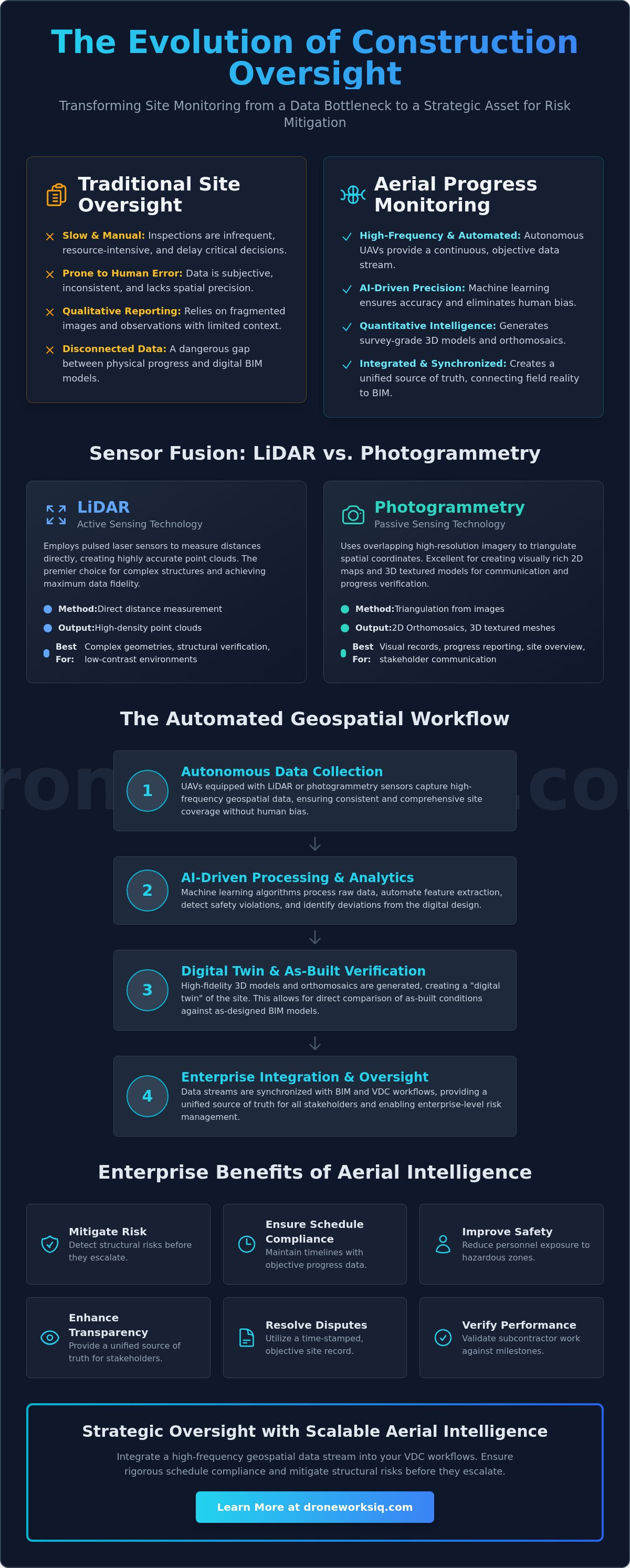
Automated Geospatial Analytics: Transforming Raw Imagery into Intelligence
Raw data acquisition is merely the foundational step in a sophisticated intelligence pipeline. The true value of aerial construction progress monitoring lies in the analytical layer where AI-driven algorithms perform automated feature extraction and object recognition. By processing high-resolution point clouds and orthomosaics through machine learning models, firms transform static imagery into dynamic datasets that quantify physical progress with mathematical precision. This computational layer enables the identification of specific assets, such as heavy machinery or structural steel components, without the need for manual tagging. This shift facilitates proactive project management, allowing teams to address logistical bottlenecks or structural deviations before they impact the critical path.
Scientific analysis regarding UAVs for Physical Progress Monitoring of Construction confirms that automated systems significantly reduce the latency between data capture and actionable insight. Machine learning doesn't just track progress; it identifies safety violations and structural anomalies that human inspectors might overlook during manual site walks. These systems provide a persistent, objective audit trail that is essential for complex infrastructure projects where the volume of data exceeds human processing capacity. To complement these broad site insights with specialized building envelope data, check out 1ESX Roof & Wall Reports for high-precision digital measurement solutions.
Automated Volumetric and Earthwork Analysis
Quantifying earthwork progress is a primary application of automated geospatial analytics. High-precision volumetric analysis allows for the calculation of cut-and-fill volumes with sub-centimeter accuracy, optimizing onsite logistics and material transport. By monitoring stockpile changes over time, project leads verify subcontractor billing against actual moved volumes, ensuring financial transparency and preventing overpayment. This data isn't siloed; it's integrated into broader site resource management strategies to maintain lean operations throughout the site preparation and foundation phases. For example, tracking the depletion rate of aggregate stockpiles allows for automated reordering, preventing downtime caused by material shortages.
Deviation Detection and Quality Control
Automated quality control relies on the persistent comparison of as-built data against as-designed BIM models. This process identifies structural misalignments or utility placement errors early in the construction phase, preventing the cascading costs associated with late-stage rework. The systematic comparison of as-built reality against as-designed BIM models identifies spatial discrepancies in real-time, preventing compounding structural errors and directly maximizing project ROI through significant rework reduction. Utilizing these high-frequency analytical streams ensures that the physical structure adheres strictly to the engineered specifications, maintaining the long-term integrity of the asset. By leveraging specialized Construction Intel, decision-makers gain a comprehensive view of the project's health, ensuring that every phase of the build meets rigorous quality standards.
Enterprise Integration: Synchronizing UAV Data with BIM and VDC Workflows
The establishment of a seamless data pipeline ensures that aerial construction progress monitoring outputs are immediately accessible within Virtual Design and Construction (VDC) environments. This integration relies on the rigorous standardization of data formats to facilitate cross-platform interoperability. Utilizing industry-standard extensions such as LAZ for compressed point clouds, E57 for high-density laser scans, and GeoTIFF for orthomosaic imagery prevents the data silos often associated with proprietary software ecosystems. Coordinate system alignment remains the most critical technical factor in this synchronization. Precise georeferencing and alignment with the project's local coordinate system are mandatory to ensure that BIM overlays provide the spatial accuracy required for automated deviation detection. Effective management of massive geospatial datasets necessitates robust cloud-based storage strategies to mitigate the processing bottlenecks typical of high-frequency data streams.
Digital Twin Integration for Real-Time Oversight
The creation of high-fidelity digital twins provides a technical foundation for real-time site oversight. These models evolve alongside the physical asset, providing a persistent, interactive record of the construction lifecycle from groundbreaking to completion. Remote site inspections become a reality for global stakeholders through immersive 3D model environments, which reduces the need for frequent travel and accelerates approval cycles. Beyond the active construction phase, these digital twins serve as an invaluable historical record for future facility management and structural health monitoring. To further leverage these models for broader area development, you can explore Urban Planning Software to visualize project impacts on a city-wide scale. This persistent data layer ensures that every structural element is documented in its as-built state, providing a comprehensive reference for the entire operational life of the infrastructure.
Workflow Automation with Project Management Platforms
Reducing the latency between data capture and strategic decision-making is essential for maintaining project momentum in high-stakes environments. Modern integration strategies involve funneling aerial progress reports directly into established project management platforms like Procore or Autodesk Construction Cloud. This automation ensures that field supervisors and executives receive time-sensitive updates without the delays inherent in manual reporting. By utilizing cloud-based processing pipelines, firms transform raw sensor data into actionable insights in a fraction of the time required by traditional methods. This streamlined approach minimizes information silos and empowers teams to act on verified, data-driven evidence. To implement these advanced integration frameworks across your portfolio, explore our specialized Construction Intel services today.
Strategic Oversight with DroneWorksIQ: Scalable Aerial Intelligence
DroneWorksIQ functions as a high-level strategic partner, providing the specialized geospatial consulting and technical infrastructure required for national-scale industrial oversight. Our methodology prioritizes the systematic conversion of high-density raw data into actionable infrastructure insights, ensuring that enterprise decision-makers operate with total situational awareness. By utilizing a project-based fee structure for high-resolution LiDAR Data Collection and Analysis and photogrammetry missions, organizations eliminate the heavy capital expenditure associated with internal hardware procurement. This model maintains access to cutting-edge sensor technology without the burden of maintenance or pilot training. Effective aerial construction progress monitoring requires this level of financial and operational flexibility to remain viable across multi-year project lifecycles.
Data consistency remains a primary challenge for firms managing diverse project locations. Fragmented reporting from local vendors often leads to incompatible datasets that hinder enterprise-level analysis. DroneWorksIQ serves as a unified national partner, enforcing rigorous data quality standards that ensure cross-site comparability. Whether the project site is a remote utility corridor or an urban high-rise, the resulting geospatial intelligence adheres to a singular, survey-grade standard. This uniformity is essential for the longitudinal analysis of structural health and the automated validation of subcontractor performance across an entire national portfolio.
Advanced Geospatial Consulting
Expert interpretation of complex datasets through AI-driven analytics allows for the identification of systemic risks that standard visual inspections routinely miss. We provide strategic insights for infrastructure management and risk mitigation, moving beyond simple data delivery to offer comprehensive problem-solving. Our custom reporting is tailored specifically to executive-level decision-making requirements, distilling petabytes of geospatial information into clear, strategic trajectories. This analytical depth ensures that stakeholders don't just see the site; they understand the technical implications of every detected deviation. By leveraging our Construction Intel, firms transform raw reality capture into a persistent competitive advantage.
Scalable Autonomous Solutions
Deploying specialized hardware-including LiDAR, thermal sensors, and high-resolution imaging systems-requires a professional mission planning framework that ensures both regulatory compliance and operational safety. Our national footprint allows for the rapid mobilization of autonomous systems, providing consistent data fidelity regardless of environmental complexity. This scalability ensures that enterprise-level VDC workflows remain synchronized with physical reality across the entire portfolio. We handle the technical complexities of mission execution, from airspace authorization to sensor calibration, allowing your team to focus on high-level project management. Optimize your construction oversight with DroneWorksIQ's aerial intelligence.
Advancing Infrastructure Intelligence Through Systematic Oversight
The integration of high-frequency data streams into construction management is a technical prerequisite for large-scale infrastructure operations. This framework has established that the shift from visual documentation to quantitative analysis provides the only viable path to persistent site intelligence. By leveraging AI-driven geospatial analytics and enterprise-grade LiDAR data collection, firms eliminate the reporting latencies and human errors inherent in manual site inspections. These autonomous systems provide the sub-centimeter precision required for rigorous BIM validation and structural risk mitigation. Establishing a unified geospatial data pipeline ensures that every phase of the build adheres strictly to engineered specifications. DroneWorksIQ provides the national deployment capabilities necessary to maintain this high-fidelity standard across diverse project portfolios. Strategic oversight depends on the ability to transform complex sensor data into a reliable, actionable source of truth. Implementing a robust protocol for aerial construction progress monitoring ensures that your projects remain on the critical path with verified accuracy. Request a Strategic Consultation for Your Infrastructure Project and secure the intelligence required for complex build environments. You don't have to compromise on data fidelity when managing high-stakes assets.
Frequently Asked Questions
What is aerial construction progress monitoring?
Aerial construction progress monitoring is a systematic reality capture protocol that utilizes autonomous UAV systems to collect high-frequency geospatial data for site validation. This process transforms physical site conditions into quantitative digital intelligence, allowing project managers to verify as-built progress against as-designed BIM models. By establishing a persistent record of the construction lifecycle, it facilitates objective oversight and proactive risk mitigation across complex infrastructure environments.
How does LiDAR differ from photogrammetry for construction sites?
LiDAR utilizes active laser pulses to measure distances directly, whereas photogrammetry is a passive sensing method that triangulates spatial coordinates from overlapping high-resolution imagery. LiDAR offers superior performance in penetrating dense vegetation and capturing complex vertical geometry with high precision. Photogrammetry is typically favored for generating detailed 2D orthomosaics and 3D textured meshes where visual context and surface color are the primary requirements for site documentation.
Can drone data be integrated directly into BIM software like Revit or Navisworks?
Geospatial data captured via UAV systems integrates seamlessly into BIM environments such as Revit or Navisworks through standardized file formats like LAZ, E57, and GeoTIFF. This interoperability allows for direct overlay of as-built point clouds onto architectural models, enabling automated deviation detection. Successful integration requires rigorous coordinate system alignment to ensure that the aerial datasets match the project's local survey control points with sub-centimeter accuracy.
What is the typical accuracy level of aerial construction surveys?
Modern aerial surveys achieve sub-centimeter Ground Sampling Distance (GSD) and relative spatial accuracy within the resulting point cloud. When utilizing Real-Time Kinematic (RTK) positioning or established Ground Control Points (GCPs), absolute global accuracy typically ranges between one and three centimeters. This level of precision is necessary for verifying structural tolerances and performing high-fidelity volumetric calculations that meet engineering standards for large-scale infrastructure projects.
How often should aerial progress monitoring be performed on a large-scale project?
The frequency of aerial construction progress monitoring sessions depends on the project's current phase and the velocity of physical site changes. For high-activity periods such as earthworks or structural framing, weekly or bi-weekly data collection is recommended to maintain an accurate digital twin. This high-frequency cadence ensures that deviations are identified before they impact the critical path, providing a persistent audit trail for contractual and logistical validation.
Does aerial monitoring help in reducing construction insurance premiums?
Aerial monitoring provides the objective, time-stamped documentation required to mitigate structural risk and liability, which can influence insurance evaluations. By maintaining a comprehensive record of site conditions and safety protocols, firms demonstrate a proactive approach to risk management. This persistent oversight can lead to more favorable underwriting terms by reducing the uncertainty associated with site incidents and structural failures during the construction lifecycle.
What are the regulatory requirements for operating drones on construction sites?
Commercial drone operations in the United States must comply with FAA Part 107 regulations, which require certified remote pilots and specific airspace authorizations. Construction sites also necessitate strict adherence to internal safety protocols and the maintenance of comprehensive liability insurance. Professional mission planning involves establishing clear flight boundaries and ensuring that autonomous systems operate without interfering with active machinery or personnel on the ground.
How does automated volumetric analysis improve earthwork management?
Automated volumetric analysis utilizes high-density point clouds to calculate cut-and-fill volumes with significantly higher precision than traditional manual methods. This capability allows project leads to verify subcontractor earthwork billing against actual material movement, preventing overpayment and logistical bottlenecks. Integrating these volumetric data streams into site resource management strategies optimizes the deployment of heavy machinery and ensures that material stockpiles are managed with mathematical accuracy.


