
UAV Land Surveying: A Comparative Analysis of Aerial Intelligence vs. Traditional Methodologies in 2026
- Dan

- Jun 13
- 12 min read
Updated: Jun 14
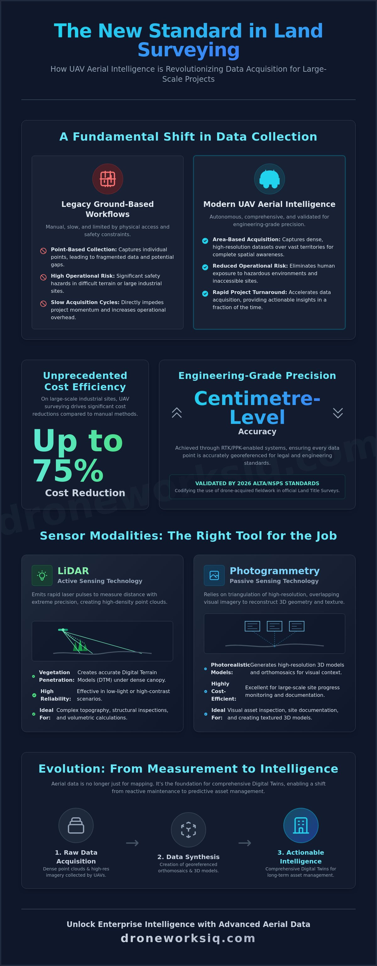
The 2026 ALTA/NSPS Land Title Survey standards now explicitly validate drone-acquired fieldwork, codifying a shift where uav land surveying provides cost efficiencies of up to 75 percent on large-scale industrial sites. Traditional manual methodologies frequently encounter systemic bottlenecks, including fragmented data silos and significant safety risks in high-hazard environments. You're likely aware that slow data acquisition cycles directly impede project momentum and increase operational overhead. This article provides an authoritative technical evaluation of how advanced aerial intelligence transforms raw geospatial data into actionable enterprise intelligence.
We'll examine the deployment of RTK-enabled systems to achieve centimetre-level accuracy and the subsequent synthesis of this data into sophisticated Digital Twin models. Precision is no longer optional. This analysis contrasts legacy ground-based workflows with modern autonomous systems, focusing on rapid project turnaround and the rigorous reduction of operational risk. Through this lens, the transition from manual measurement to comprehensive aerial oversight emerges as a strategic necessity for 2026 infrastructure management and large-scale land development projects.
Key Takeaways
Analyze the fundamental shift from terrestrial point-collection to high-resolution area-based imaging for enhanced spatial awareness.
Contrast the penetration capabilities of active LiDAR sensors against image-based photogrammetry for complex terrain and dense vegetation analysis.
Assess the efficiency gains and safety improvements inherent in uav land surveying when operating across hazardous or vast industrial territories.
Define the validation frameworks and precision benchmarks necessary to ensure geospatial data meets centimetre-level engineering requirements.
Implement strategies for synthesizing raw aerial data into comprehensive Digital Twins for long-term infrastructure optimization and asset management.
Defining UAV Land Surveying within the Enterprise Aerial Intelligence Ecosystem
Modern industrial operations demand higher spatial fidelity than legacy terrestrial methods can provide. UAV land surveying represents a transition from manual, point-based data collection to high-resolution, area-based acquisition methodologies. This approach utilizes autonomous systems to capture dense datasets across vast territories, ensuring comprehensive oversight where traditional methods struggle with hazardous terrain or inaccessible sites. It isn't just about capturing images; it's about the systematic collection of geospatial data that informs high-stakes decision-making. Data density is paramount.
Precision positioning is the cornerstone of these systems. Integration of Global Navigation Satellite Systems (GNSS) with Real-Time Kinematic (RTK) or Post-Processed Kinematic (PPK) correction allows for centimetre-level positioning without the exhaustive time requirements of manual terrestrial setups. These technologies ensure every data point is accurately georeferenced within global coordinate systems. Enterprise-scale aerial intelligence is distinguished from consumer-grade mapping by the precision of its sensor payloads and the rigor of its validation protocols. While hobbyist drones offer visual context, professional systems provide georeferenced accuracy suitable for legal and engineering standards required by national infrastructure projects.
The Core Components of UAV Geospatial Systems
The efficacy of an aerial intelligence strategy depends on hardware-software synergy. Multi-rotor systems excel in vertical facade inspection and localized high-precision mapping due to their hovering capabilities. Conversely, fixed-wing platforms prioritize endurance for expansive utility or pipeline corridors. High-resolution RGB sensors facilitate detailed unmanned aerial photogrammetric survey workflows, creating high-fidelity visual representations of the terrain. LiDAR payloads provide a critical advantage by using active sensor pulses to penetrate dense vegetation, revealing underlying topography that photogrammetry cannot reach. Raw data then flows through systematic processing pipelines to produce georeferenced orthomosaics and high-density point clouds.
Evolution from Measurement to Intelligence
The utility of aerial data has expanded beyond simple measurement. It now serves as a foundational layer for proactive infrastructure management and structural risk assessment. This evolution allows stakeholders to transition from reactive maintenance to predictive oversight, identifying potential failures before they compromise operational integrity. Traditional 2D mapping has evolved into complex 3D volumetric analysis and structural modeling, enabling stakeholders to visualize assets within a high-fidelity spatial context. This depth of information is essential for maintaining Digital Twins and optimizing national asset management frameworks. UAV land surveying, such as the services provided by Impact Aerial, is the synthesis of autonomous flight and geospatial analytics.
Technical Modalities: Photogrammetry vs. LiDAR in UAV Land Surveying
UAV land surveying utilizes two primary distinct sensor modalities for geospatial data acquisition: Light Detection and Ranging (LiDAR) and photogrammetry. While both provide high-fidelity spatial datasets, their technical mechanisms and operational constraints differ significantly. LiDAR operates as an active sensing technology. It emits rapid laser pulses to measure distances with extreme precision. Photogrammetry operates as a passive methodology. It relies on the triangulation of high-resolution visual imagery to reconstruct three-dimensional geometry. Selection between these modalities depends on environmental variables such as vegetation density, required visual fidelity, and atmospheric conditions. Choosing the wrong modality results in data gaps that compromise the entire enterprise intelligence lifecycle.
LiDAR: Precision Terrain Mapping and Vegetation Penetration
LiDAR sensors facilitate the creation of highly accurate Digital Terrain Models (DTM) by penetrating dense canopy cover. This is achieved through multi-return signals where laser pulses bypass foliage to strike the underlying ground surface. The resulting high-density point clouds allow for complex structural inspections and volumetric calculations in environments where visual sensors would fail. According to the UAS for Land Surveying Tech Brief, these active systems maintain operational efficacy in low-light or high-contrast scenarios that typically degrade photogrammetric results. This reliability makes LiDAR indispensable for large-scale infrastructure mapping in topographically challenging zones. It ensures that ground surface data remains consistent regardless of surface-level obstructions.
Photogrammetry: High-Resolution Visual Documentation and Texturing
Photogrammetric workflows generate photorealistic 3D models and orthomosaics through the mathematical alignment of overlapping images. Accuracy in these models is dictated by Ground Sample Distance (GSD) and the percentage of image overlap, which ensures robust triangulation of features. This modality is exceptionally cost-efficient for large-scale site progress monitoring and visual documentation where surface texture is a priority. It doesn't just provide coordinates; it provides visual context that LiDAR often lacks. For projects requiring high-resolution visual documentation, specialized drone mapping and photogrammetry services provide the necessary detail for comprehensive asset analysis. The resulting datasets are easily integrated into existing CAD and GIS platforms.
The emergence of sensor fusion represents the current zenith of aerial intelligence. By integrating LiDAR’s structural precision with photogrammetry’s visual texturing, operators can create hyper-realistic digital twins. These models serve as the definitive record for infrastructure optimization, combining geometric accuracy with high-fidelity surface data. This fusion eliminates the compromise between accuracy and visual clarity. Modality selection must remain a data-driven decision based on specific project goals. Environmental constraints dictate the primary sensor, but the integration of both often yields the most comprehensive enterprise intelligence for long-term strategic planning.
Comparison: UAV Land Surveying vs. Traditional Terrestrial Methodologies
Traditional terrestrial methodologies necessitate physical presence at every measured coordinate, a process inherently limited by human mobility and site accessibility. This legacy approach relies on discrete point acquisition via total stations or GNSS rovers, resulting in a low-fidelity representation of the terrain. In contrast, uav land surveying facilitates the acquisition of thousands of points per square metre, providing a near-continuous digital surface representation. This shift from sparse sampling to dense data capture eliminates the interpolation errors common in terrestrial workflows. The Comparative Study of Lidar and Photogrammetry demonstrates how these aerial modalities surpass legacy point density by several orders of magnitude, ensuring that critical topographic features aren't missed between manual shots. Furthermore, the logistics of reaching these sites often require professional navigation skills; for teams operating in the South West London region, Wimbledon Driving School provides the expert instruction necessary to manage road travel safely.
Economic analysis reveals a significant reduction in man-hours per acre when transitioning to aerial systems. Large-scale projects that previously required weeks of fieldwork can now be completed in hours of flight time, often yielding 50-75 percent cost savings for sites exceeding five acres. Regulatory compliance for national-level operations is maintained through adherence to FAA Part 107 standards, with anticipated Part 108 frameworks poised to further expand beyond visual line of sight (BVLOS) capabilities. This structured regulatory environment ensures that enterprise data collection remains both legal and standardized across complex jurisdictional boundaries.
Operational Efficiency and Risk Mitigation
UAV systems provide a decisive advantage in linear infrastructure projects such as pipeline and utility corridors. Aerial acquisition allows for non-intrusive data collection, effectively reducing site downtime and eliminating the need for ground crews to navigate hazardous or inaccessible zones. Safety protocols are significantly enhanced during facade inspections and high-altitude surveying, where autonomous systems replace high-risk manual climbing or scaffolding setups. By removing personnel from the immediate vicinity of industrial hazards, enterprises drastically lower their operational risk profile while maintaining a high cadence of data acquisition.
Data Depth and Analytical Potential
The transition to aerial intelligence creates 'rich' datasets that facilitate multiple analytical outcomes from a single deployment. Unlike legacy data, which provides a static survey timestamp, modern aerial models are dynamic and easily integrated into evolving project lifecycles. This allows stakeholders to move beyond basic measurement into complex trend analysis and volumetric tracking. Effective data transformation relies on AI-driven geospatial analytics to extract actionable intelligence from these massive point clouds. This analytical depth ensures that the captured data remains relevant for the duration of the asset's operational life, supporting long-term infrastructure optimization.
Accuracy Benchmarks and Validation Protocols for Aerial Geospatial Data
Achieving centimetre-level precision in uav land surveying requires the systematic integration of high-fidelity sensors, robust positioning hardware, and rigorous validation protocols. Horizontal accuracy benchmarks typically range from 1 to 3 centimetres, while vertical accuracy is maintained between 2 and 5 centimetres when utilizing survey-grade equipment. These metrics are not theoretical; they are the result of multi-constellation GNSS receivers synchronized with high-resolution sensor payloads. The 2026 ALTA/NSPS standards have refined the definition of Relative Positional Precision to account for these advanced measurement capabilities. Maintaining these tolerances is essential for the generation of engineering-grade datasets that support national infrastructure development.
Positional correction methodologies are divided between Real-Time Kinematic (RTK) and Post-Processed Kinematic (PPK) workflows. RTK provides immediate correction data during flight via a base station or NTRIP network, ensuring precise image triggering and navigation. Conversely, PPK correction occurs after data acquisition, offering superior reliability in environments characterized by intermittent signal reception or complex electromagnetic interference. Both methodologies require the strategic placement of Ground Control Points (GCPs) to anchor the dataset to absolute global coordinates. Standardized reporting formats now include comprehensive audit trails that document every correction parameter for regulatory and enterprise compliance. For organizations requiring high-fidelity topographic data, professional LiDAR data collection and analysis ensures these accuracy benchmarks are consistently met across diverse terrains.
Validation Frameworks for Survey-Grade Results
Validation relies on the deployment of independent checkpoints that remain separate from the initial processing model. This separation facilitates an unbiased assessment of both absolute and relative accuracy across the surveyed area. GCPs must be distributed evenly across the site, with particular attention to elevation changes and peripheral boundaries to prevent model warping. Industrial-grade UAV surveys require vertical tolerances within 5 centimetres and horizontal variances under 3 centimetres to meet engineering-grade specifications. These checkpoints provide the quantitative evidence required to certify the survey for legal or structural applications.
Error Mitigation and Quality Assurance
Data quality is heavily influenced by flight parameters including altitude, velocity, and image overlap. Lower altitudes decrease Ground Sample Distance (GSD), increasing spatial resolution, while high overlap percentages (typically 80 percent frontal and 70 percent side) are necessary to eliminate reconstruction artefacts in photogrammetric models. Atmospheric conditions, such as high heat haze or high-velocity winds, introduce noise into LiDAR point clouds and visual distortions in RGB imagery. Software-based refinement processes utilize advanced algorithms to filter out sensor noise and correct for rolling shutter effects. This systematic quantification of spatial variance ensures that the final digital output is a precise reflection of the physical asset.
Strategic Implementation of UAV Intelligence for Infrastructure Optimization
Strategic implementation of uav land surveying necessitates a transition from isolated data capture to integrated geospatial intelligence. Large-scale infrastructure projects require a foundational layer of accurate spatial data that feeds directly into national asset management frameworks. This integration facilitates a standardized approach to oversight, ensuring that every bridge, pipeline, and utility corridor is monitored within a unified coordinate system. The use of AI-driven analytics accelerates this process by automating feature extraction and facilitating rapid change detection across successive datasets. By identifying subtle structural shifts or environmental encroachments before they escalate, enterprises transition from reactive repairs to proactive asset optimization. This methodology ensures that infrastructure remains resilient against both environmental degradation and operational wear.
Digital Twinning and Lifecycle Management
High-fidelity uav land surveying data serves as the primary input for specialized Digital Twinning Services. These digital replicas allow for continuous structural integrity monitoring and the simulation of environmental stressors in a risk-free virtual environment. Seamless integration into existing Building Information Modeling (BIM) and Geographic Information System (GIS) platforms ensures that aerial insights are accessible across the entire enterprise stack, from field engineers to executive decision-makers. This lifecycle management approach includes the systematic tracking provided by erosion monitoring services and the identification of vegetation encroachment along critical utility corridors. Predictive maintenance protocols are then established based on empirical spatial evidence rather than arbitrary time-based schedules, significantly extending the operational life of the asset.
The ROI of Autonomous Aerial Intelligence
Scalability is the defining characteristic of autonomous aerial intelligence. National utility and pipeline inspection services benefit from repeatable flight paths that ensure temporal consistency in data acquisition. This repeatability allows for the precise quantification of site changes over months or years, providing a clear ROI through the early detection of infrastructure anomalies. Strategic consulting moves beyond simple data collection; it provides the actionable intelligence required for high-stakes capital expenditure decisions. DroneWorksIQ functions as a sophisticated partner in this geospatial transformation, providing the technical depth required to manage complex, high-stakes data environments with methodical accuracy. Partnering with experts in drone mapping and photogrammetry services ensures that the resulting datasets are not just accurate, but strategically relevant to long-term organizational goals. This approach future-proofs infrastructure through the application of methodical, data-driven oversight.
Advancing Geospatial Integrity through Autonomous Oversight
The transition toward uav land surveying represents a fundamental shift from sparse terrestrial sampling to dense, area-based aerial acquisition. This methodology provides the foundational layer for high-fidelity spatial intelligence, ensuring that legacy data gaps are eliminated through systematic sensor fusion. By synthesizing active LiDAR sensors with AI-driven analytics, enterprises achieve a level of structural fidelity that traditional methodologies cannot replicate. This evolution is essential for maintaining the rigorous accuracy benchmarks required by 2026 ALTA/NSPS standards and national infrastructure frameworks.
Precision and reliability remain the core pillars of modern infrastructure management. Organizations that prioritize autonomous data collection and digital twinning expertise position themselves for superior operational oversight and long-term risk mitigation. DroneWorksIQ provides the specialized technical depth required to transform raw geospatial data into actionable enterprise intelligence across complex industrial environments. Partner with DroneWorksIQ for enterprise-scale aerial intelligence to leverage specialized LiDAR and advanced geospatial analytics for your next national infrastructure project. Secure your strategic advantage through methodical accuracy.
Frequently Asked Questions
What is the typical accuracy of UAV land surveying compared to traditional methods?
Modern uav land surveying achieves horizontal accuracy benchmarks of 1 to 3 centimetres and vertical accuracy of 2 to 5 centimetres when utilizing RTK/PPK correction and ground control points. This precision level aligns with the requirements for most industrial engineering and construction applications. While traditional terrestrial methods can reach sub-centimetre precision for specific legal boundary markers, aerial methodologies provide superior data density across the entire site area.
Can UAV land surveying penetrate dense vegetation or forest canopy?
UAVs equipped with LiDAR sensors penetrate dense vegetation by utilizing active laser pulses that bypass foliage to strike the underlying terrain. These sensors capture multiple returns from a single pulse, allowing for the simultaneous mapping of both the forest canopy and the ground surface. This capability is essential for creating accurate Digital Terrain Models (DTMs) in topographically complex or heavily wooded environments where photogrammetry is ineffective.
How do RTK and PPK technologies improve drone mapping precision?
RTK and PPK technologies reduce GNSS positional errors from several metres to centimetre-level by applying satellite correction data. RTK provides these corrections in real-time via a base station or network link, ensuring precise image triggering during flight. PPK processes the correction data after the mission, offering higher reliability in environments with intermittent signal reception or complex electromagnetic interference, which is critical for maintaining survey-grade integrity.
Is UAV land surveying compliant with national surveying standards and regulations?
Commercial operations must adhere to FAA Part 107 regulations, and the 2026 ALTA/NSPS standards now explicitly recognize drone-acquired fieldwork as a valid data collection methodology. Compliance requires a certified remote pilot and, in many jurisdictions, a licensed surveyor to validate and seal the final deliverables. These frameworks ensure that aerial geospatial data meets the rigorous legal and safety requirements mandated for national infrastructure projects.
What types of deliverables are produced from a professional UAV survey?
Standard deliverables include high-resolution orthomosaic maps, 3D point clouds, digital elevation models (DEMs), and detailed contour maps. These datasets are exported in formats compatible with enterprise CAD, BIM, and GIS platforms for immediate integration into project workflows. Advanced outputs also encompass textured 3D meshes and volumetric analysis reports, which provide the foundational data for sophisticated Digital Twin models and infrastructure asset management.
How does weather and lighting affect the quality of aerial surveying data?
High-velocity winds, heavy precipitation, and extreme heat haze introduce noise into LiDAR data and cause visual distortions in photogrammetric imagery. Passive visual sensors require consistent ambient lighting for accurate feature triangulation, whereas active LiDAR sensors maintain operational efficacy in low-light or high-contrast conditions. Atmospheric instability can also compromise flight safety and platform stability, directly impacting the spatial consistency of the acquired geospatial datasets.
What is the cost-benefit ratio of switching from ground-based to UAV surveying?
Transitioning to aerial methodologies results in cost savings of 50 to 75 percent for sites exceeding five acres due to the radical reduction in fieldwork man-hours. Rapid data acquisition allows a 50-acre site to be surveyed in approximately 45 minutes, a task that typically requires multiple days for terrestrial crews. The resulting ROI is further enhanced by the elimination of site downtime and the acquisition of hyper-dense datasets that support long-term predictive maintenance.
How is AI used to process and analyse UAV land surveying data?
AI algorithms automate the classification of massive point clouds, facilitating the rapid separation of ground surfaces from vegetation and man-made infrastructure. Machine learning models enable automated feature extraction and change detection, identifying structural anomalies or measuring volumetric shifts with minimal human intervention. This automation transforms raw uav land surveying data into actionable intelligence, reducing processing timelines and providing stakeholders with critical insights for infrastructure optimization.


