
Precision Mapping: Leveraging DJI RTK3 for Accurate Data
- Dan

- Jun 15
- 8 min read
Data integrity in complex industrial environments is non-negotiable; a deviation of even 6 inches can render a digital twin obsolete for structural analysis. The DJI RTK3 serves as the definitive hardware foundation for professionals facing signal degradation and range limitations during large-scale infrastructure inspections. Technical stakeholders recognize that traditional GNSS systems frequently fail to maintain consistency when navigating dense utility corridors or expansive pipelines. This analysis details the strategic role of the DJI D-RTK 3 Multifunctional Station in achieving centimeter-level accuracy for critical data collection. It's a technical examination of how this system eliminates inconsistencies between ground control and aerial sensors while expanding operational capabilities in high-stakes environments. We examine the technical specifications and operational modes, including a relay function that extends transmission range to 49,212 feet; these features facilitate seamless integration with LiDAR and 3D modeling software for superior geospatial oversight.
Key Takeaways
Analyze the high-performance GNSS antenna array and integrated inertial measurement units that enable precise multi-constellation satellite tracking for industrial applications.
Optimize operational flexibility by leveraging the DJI RTK3 in Base, Rover, and Relay modalities to facilitate simultaneous multi-UAV corrections and ground control point collection.
Enhance the fidelity of digital twinning services through noise reduction in LiDAR point cloud analysis, achieving sub-decimeter absolute accuracy for construction site models.
Implement standardized RTK protocols to improve safety and data consistency for large-scale utility, facade, and pipeline inspection services.
Technical Architecture of the DJI RTK3 Multifunctional Station
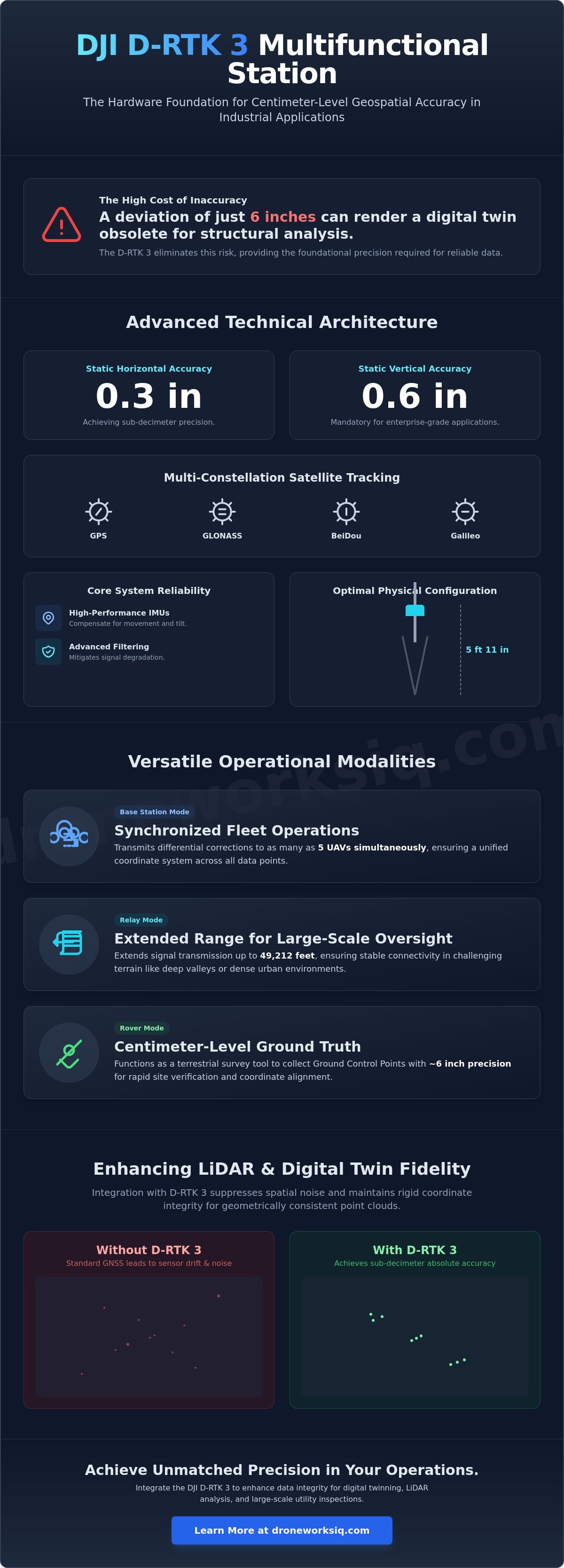
The DJI RTK3 represents a significant advancement in terrestrial positioning hardware, functioning as a high-performance geospatial engine rather than a simple receiver. It utilizes a sophisticated GNSS antenna array capable of simultaneous multi-constellation tracking across GPS, GLONASS, BeiDou, and Galileo. This multi-path redundancy is essential for maintaining signal lock in environments where physical obstructions or atmospheric conditions threaten data continuity. By integrating Real-Time Kinematic (RTK) positioning technology, the station achieves a static horizontal accuracy of approximately 0.3 inches and a static vertical accuracy of 0.6 inches. These tolerances are mandatory for enterprise-grade applications where sub-decimeter precision defines the project's success.
System reliability is further enhanced through the integration of high-performance inertial measurement units (IMU) for dynamic orientation resolution. Unlike standard base stations, the D-RTK 3 uses these sensors to compensate for movement and tilt, ensuring that orientation data remains valid even during field deployment challenges. In electromagnetically dense industrial sectors, the hardware's advanced filtering algorithms mitigate signal degradation caused by high-voltage equipment or heavy machinery. This resilience ensures that data captured for utility and pipeline inspection services remains consistent and free from the noise typically associated with unshielded GNSS equipment.
Key Takeaway
The D-RTK 3 provides the foundational precision required for autonomous geospatial intelligence, ensuring data consistency across complex industrial sites.
Infographic: D-RTK 3 System Architecture
The system architecture visualization details the following components:
GNSS Signal Flow: A schematic representing the communication path between orbital constellations, the D-RTK 3 station, and the UAV fleet via the O3 Enterprise transmission protocol.
Physical Configuration: A diagram of the 5 ft 11 in survey pole and specialized tripod assembly, illustrating the optimal height for signal reception and ground stability.
Controller Integration: A visual mapping of the real-time data link between the station and the remote controller for live accuracy monitoring.
Operational Modalities: Base, Rover, and Relay Systems
The DJI RTK3 transitions seamlessly between three distinct operational states, allowing enterprise teams to adapt to shifting field requirements without hardware reconfiguration. In Base Station Mode, the unit transmits differential corrections to as many as five UAVs simultaneously. This capability is critical for synchronized fleet operations where high-density data capture must remain temporally aligned across multiple sensors. Organizations utilizing our Utility and Pipeline Inspection Services find this multi-drone support essential for maintaining high throughput across expansive linear assets while ensuring every data point adheres to a unified coordinate system.
Extended Range Capabilities for National Utilities
The Relay Mode represents a significant breakthrough for large-scale infrastructure oversight. Analysis of signal propagation across a 49,212-foot radius confirms the system's efficacy in challenging terrain. This distance is vital for monitoring remote assets where signal occlusion frequently occurs. In deep-valley or high-rise urban environments, the relay minimizes packet loss and ensures a stable downlink, facilitating uninterrupted data streams for complex geospatial analysis. It's a strategic solution for maintaining connectivity in environments that typically degrade standard radio frequencies.
Centimeter-Level Ground Truth Collection
When configured in Rover Mode, the hardware functions as a terrestrial surveying tool for establishing ground truth. Operators use the DJI Enterprise app to collect ground control points with a precision of approximately 6 inches for rapid verification. This integration with DJI Terra allows for automated coordinate system alignment, ensuring that the final digital output matches the physical site with absolute fidelity. The system's seamless integration with the DJI Dock 2 and the DJI RTK3 further enables autonomous, remote-site deployments. It provides a persistent and reliable positioning reference for unattended aerial intelligence operations, reducing the need for manual intervention in high-risk zones.
Strategic Integration: Enhancing LiDAR and Digital Twin Fidelity
High-fidelity geospatial intelligence depends on the precision of the underlying positioning data. Integrating the DJI RTK3 into complex sensor workflows directly facilitates superior LiDAR point cloud analysis by suppressing spatial noise and improving geometric consistency. While standard GNSS systems struggle with sensor drift during extended flights, the RTK3 maintains rigid coordinate integrity. This hardware-driven stability allows for the construction of digital twins with sub-decimeter absolute accuracy, which is less than 4 inches of deviation, a requirement for high-stakes construction intel and structural monitoring. The alignment of RTK data with AI-driven geospatial analytics enables automated feature extraction, where the system identifies specific infrastructure components with high confidence based on their precise spatial signatures.
The reduction of reliance on dense ground control networks represents a significant operational efficiency. By leveraging high-precision aerial positioning, field teams can achieve centimeter-level results without the logistical burden of manual marker placement across vast project sites. This streamlined approach accelerates the delivery of actionable insights for large-scale utility and pipeline inspection services, where speed and accuracy are equally prioritized. It's a fundamental shift from manual validation to automated, high-precision oversight.
Optimizing LiDAR Data Collection
Long-endurance aerial scans often suffer from cumulative orientation errors that distort the final point cloud. The RTK3 mitigates these discrepancies by providing continuous, real-time corrections that stabilize LiDAR sensor orientation data. This stabilization ensures that the point cloud remains uniform across multiple flight paths, preventing the ghosting effects that occur when data strips fail to align. It's an essential technical requirement for mapping complex, three-dimensional structures like transmission towers or dense industrial facilities.
Infrastructure Intelligence Transformation
Infrastructure intelligence transformation relies on the ability to detect minute physical changes over time. High-precision positioning enables automated change detection in digital twins by ensuring that every survey occupies the exact same coordinate space. This precision ensures temporal consistency across multi-year erosion monitoring projects, allowing analytics to distinguish between actual structural shifts and sensor-induced artifacts. For stakeholders managing national assets, this level of accuracy is the difference between proactive maintenance and catastrophic failure. Secure your project's data integrity by utilizing our specialized Digital Twinning Services for high-precision modeling.
Deploying D-RTK 3 for National Infrastructure Intelligence
Standardization of RTK protocols across national utility and pipeline inspection fleets establishes a foundation for cross-departmental data interoperability. Utilizing the DJI RTK3 allows enterprise organizations to maintain a consistent geospatial reference across diverse geographic regions, ensuring that every asset is localized within a unified coordinate system. This technical consistency is particularly critical during high-stakes facade inspection services, where the requirement for precision proximity flight necessitates unwavering positioning stability. By achieving a reliable signal lock within 4 inches of a vertical surface, operators effectively mitigate the kinetic risks associated with urban infrastructure analysis.
Future-proofing aerial data strategies involves the strategic integration of the DJI Dock 2 and the RTK3 station for persistent, unattended oversight. This combination facilitates autonomous mission execution with the same centimeter-level accuracy expected from manual surveys, providing a scalable solution for national infrastructure intelligence. The transition to autonomous, high-precision data capture reduces the logistical overhead of traditional field operations while increasing the frequency and reliability of asset health assessments.
Enterprise Implementation Framework
Deploying high-precision hardware at remote infrastructure sites follows a structured workflow designed for rapid operational readiness. This framework prioritizes data security, utilizing advanced encryption standards for RTK signal transmission to prevent unauthorized access to sensitive positioning telemetry. The process includes site calibration and the establishment of secure communication links between the ground station and the autonomous flight controller, ensuring that data integrity is maintained from the point of capture to final analytical processing.
The DroneWorksIQ Advantage
The DroneWorksIQ methodology moves beyond raw hardware deployment to deliver comprehensive infrastructure intelligence. By merging sophisticated hardware with specialized geospatial consulting, the brand provides the technical depth required for complex, high-stakes data environments. Organizations requiring sub-decimeter fidelity for their strategic assets should request a consult for aerial LiDAR data collection using RTK3 technology to leverage superior analytical results and professional oversight.
Advancing Autonomous Infrastructure Intelligence
Centimeter-level precision has transitioned from a specialized requirement to a mandatory baseline for high-fidelity digital twinning and structural analysis. Integrating the DJI RTK3 provides the technical foundation necessary to overcome signal degradation in electromagnetically dense industrial environments while extending operational reach for remote asset monitoring. This hardware synergy ensures that sensor orientation remains stable, facilitating the temporal consistency required for long-term erosion and structural oversight. DroneWorksIQ maintains a deep specialization in national-scale LiDAR data collection and analysis, utilizing AI-driven geospatial analytics for sophisticated enterprise asset management. Our methodology prioritizes the strategic deployment of advanced UAV systems to deliver actionable insights for high-stakes infrastructure projects across the country. It's a comprehensive approach that bridges the gap between raw hardware capabilities and strategic industrial application. Optimize your infrastructure intelligence with DroneWorksIQ advanced LiDAR services. We invite you to leverage our technical expertise to secure the future of your geospatial data assets and drive operational efficiency.
Frequently Asked Questions
What is the maximum range of the DJI D-RTK 3 in relay mode?
The maximum video transmission range of the DJI D-RTK 3 in Relay Mode is 49,212 feet under FCC standards. This functionality allows the station to act as a signal bridge, effectively mitigating signal occlusion in complex terrain or high-density urban environments. It's a critical capability for maintaining a stable downlink during long-range linear infrastructure inspections where standard radio frequencies often suffer from degradation or physical interference.
How does the D-RTK 3 improve LiDAR point cloud accuracy?
The DJI RTK3 enhances LiDAR point cloud accuracy by providing a stable, centimeter-level coordinate reference that minimizes spatial drift during data acquisition. This precision stabilizes the sensor's orientation data, which significantly reduces noise and ensures geometric consistency across multiple flight paths. The resulting high-density point clouds meet the stringent requirements for sub-decimeter digital twin construction and detailed structural analysis in industrial sectors.
Is the DJI D-RTK 3 compatible with the DJI Dock 2 for autonomous operations?
The DJI D-RTK 3 is fully compatible with the DJI Dock 2, providing the essential positioning reference required for autonomous, unattended aerial operations. This integration facilitates remote-site deployments where the station serves as a persistent GNSS anchor for the docked UAV. It ensures that automated mission execution maintains the same level of accuracy as manual surveys, allowing for high-frequency asset monitoring without manual intervention.
Can the D-RTK 3 be used as a standalone GNSS rover for ground control points?
The hardware functions as a standalone GNSS rover for the collection of ground control points when configured in Rover Mode via the DJI Enterprise app. This allows field teams to establish ground truth with a static horizontal accuracy of approximately 0.3 inches. It eliminates the need for third-party terrestrial surveying equipment, streamlining the workflow for coordinate system alignment and ensuring absolute spatial fidelity across the entire project dataset.
How does the built-in IMU in the D-RTK 3 assist in drone positioning?
The built-in inertial measurement unit (IMU) in the D-RTK 3 provides dynamic orientation resolution and tilt compensation for the station itself. This ensures that the positioning data remains accurate even if the station experiences slight movement or is deployed on uneven terrain. The IMU works in tandem with the GNSS antenna array to maintain a rigid spatial reference, preventing the propagation of orientation errors into the drone's telemetry.


