Streamline Erosion Monitoring for Construction Sites
- Dan

- Jun 6
- 11 min read
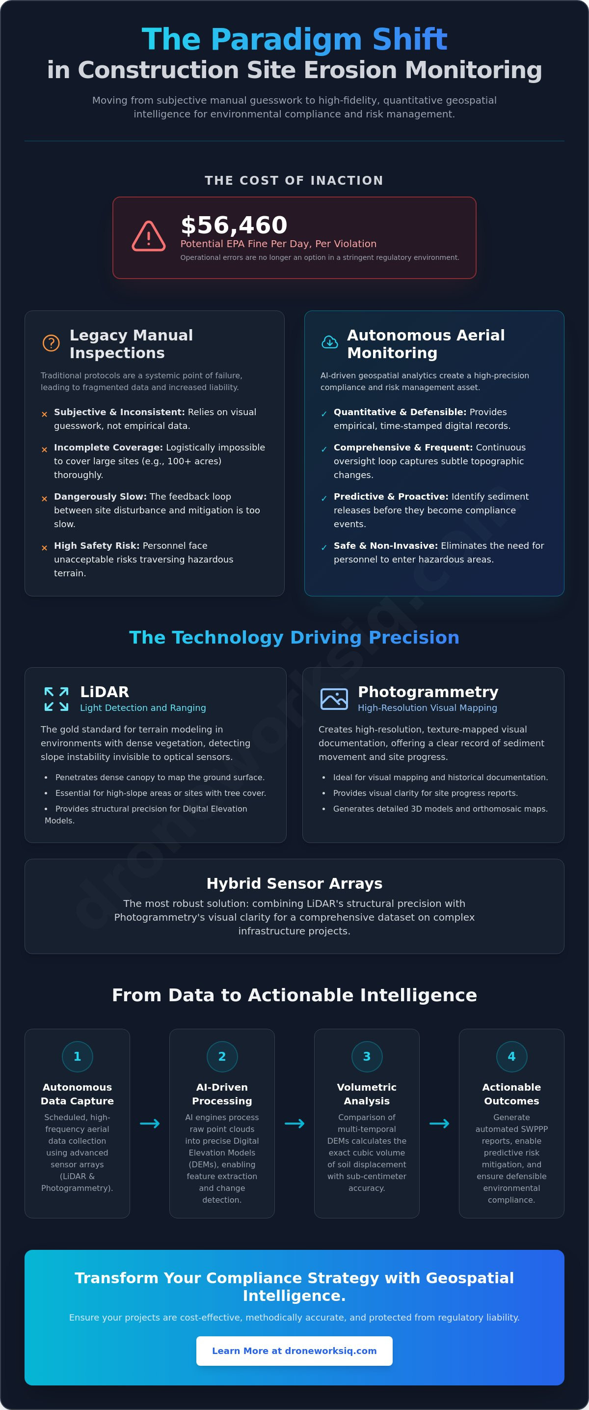
With EPA fines for Stormwater Pollution Prevention Plan violations reaching $56,460 per day per violation as of June 2026, the margin for operational error has effectively evaporated. Industry stakeholders acknowledge that legacy inspection protocols are inherently fragmented, often producing inconsistent datasets that leave large-scale projects vulnerable to undetected sediment releases. Transitioning to an advanced framework for Construction Site Erosion Monitoring and Reporting is now a technical requirement for maintaining soil stability and regulatory standing. It's the only way to replace subjective observations with empirical geospatial intelligence.
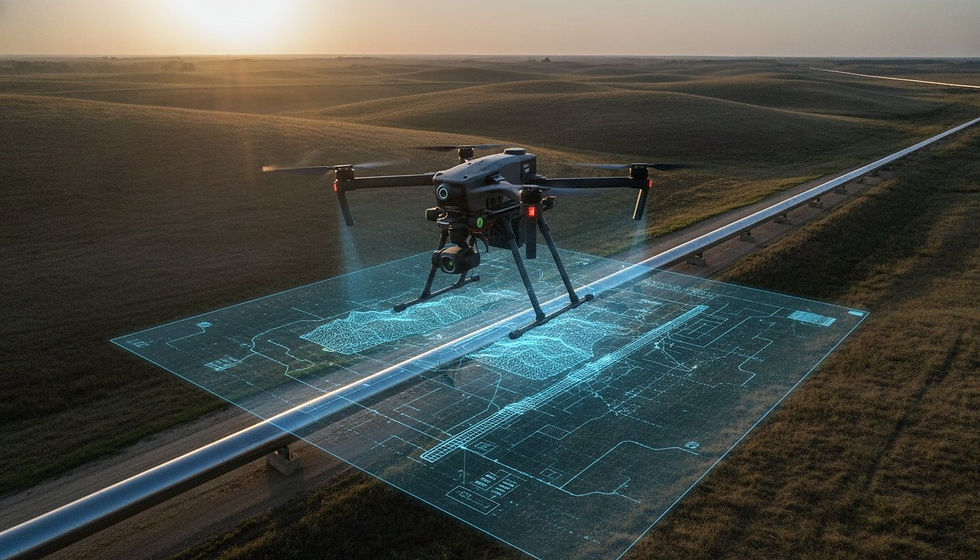
You'll discover how autonomous aerial data collection and AI-driven geospatial analytics transform erosion monitoring into a high-precision compliance and risk management asset. This discussion details the integration of LiDAR and photogrammetry to generate high-resolution volumetric erosion data and automated reporting structures. We'll examine the transition from manual site-wide monitoring to predictive risk mitigation, ensuring your operational oversight is both cost-effective and methodically accurate.
Key Takeaways
Transition from qualitative manual inspections to quantitative geospatial data sets to eliminate the subjectivity and inconsistency inherent in traditional monitoring protocols.
Leverage LiDAR for precise terrain modeling through dense vegetation and photogrammetry for high-resolution visual documentation of sediment movement.
Implement AI-driven analytics to automate Construction Site Erosion Monitoring and Reporting, facilitating rapid feature extraction and change detection for proactive site management.
Align autonomous aerial data collection with EPA and SWPPP mandates to ensure defensible environmental compliance and minimize regulatory liability.
Utilize high-resolution volumetric data to achieve predictive risk mitigation for soil stability across complex, large-scale infrastructure projects.
The Paradigm Shift in Construction Site Erosion Monitoring
Modern infrastructure projects operate at a scale that renders traditional oversight protocols obsolete. Manual inspection routines, once the industry standard, now represent a significant point of systemic failure in environmental compliance and operational efficiency. The transition toward automated Construction Site Erosion Monitoring and Reporting marks a fundamental shift from qualitative visual guesswork to high-fidelity, quantitative geospatial analysis. This evolution is driven by the necessity for defensible, empirical data in an increasingly stringent regulatory environment where visual estimates are no longer sufficient to mitigate liability.
Limitations of Manual Environmental Inspections
Manual assessments are inherently subjective. An inspector's visual estimation of sediment displacement lacks the precision required for modern volumetric analysis. On a 100-acre site, comprehensive manual coverage is a logistical impossibility, often leading to sampled observations that miss localized failures. Additionally, the physical demands of traversing unstable or hazardous terrain introduce unacceptable safety risks to personnel. These manual methods fail to capture the granular details of various Erosion control techniques, making it difficult to verify if Best Management Practices (BMPs) are functioning as engineered. Without precise measurement, the feedback loop between site disturbance and mitigation response remains dangerously slow.
Autonomous Systems and Infrastructure Intelligence
The deployment of autonomous aerial systems introduces a continuous oversight loop that human inspectors can't replicate. This workflow begins with scheduled, high-frequency data capture that feeds directly into AI-driven processing engines. By automating Construction Site Erosion Monitoring and Reporting, stakeholders can leverage high-frequency data capture to identify potential sediment releases before they escalate into compliance events. High-resolution sensors detect subtle topographic changes long before they manifest as catastrophic failures or regulatory violations. This level of oversight integrates seamlessly into broader Construction Intel portfolios, providing a singular source of truth for site stability and operational progress.
Strategic alignment of aerial intelligence with enterprise risk management frameworks is a critical requirement for modern industrial operations. High-frequency, non-invasive data collection significantly reduces site liability by providing a permanent, time-stamped digital record of site conditions that withstands legal and regulatory scrutiny. This methodical approach ensures that environmental mandates are met with clinical accuracy, protecting both the physical integrity of the landscape and the project’s long-term financial viability against the high costs of non-compliance.
Quantifying Soil Displacement via LiDAR and Photogrammetry
Quantifying earthwork movement requires more than photographic evidence; it demands high-fidelity spatial data. Digital Elevation Models (DEMs) provide the analytical foundation for longitudinal monitoring. By establishing a precise topographic baseline, enterprise operators can track sediment migration with mathematical certainty. This level of oversight is essential for adhering to EPA stormwater regulations, which mandate rigorous control of site discharges. Without a quantifiable record, contractors remain vulnerable to claims of environmental negligence and the associated legal repercussions.
LiDAR vs. Photogrammetry in Erosion Detection
Determining the optimal sensor array depends on site-specific vegetation and terrain complexity. LiDAR (Light Detection and Ranging) is the gold standard for terrain modeling in environments with dense vegetation. Its ability to penetrate canopy and return ground-level data points allows for the detection of slope instability that remains invisible to standard optical sensors. Conversely, photogrammetry provides high-resolution visual documentation, creating a texture-mapped record of sediment movement. Most sophisticated Construction Site Erosion Monitoring and Reporting workflows utilize a hybrid strategy, combining structural precision with visual clarity.
LiDAR: Prioritized for high-slope areas or sites with significant tree cover where ground visibility is obstructed.
Photogrammetry: Deployed for high-resolution visual mapping and historical documentation of site progress.
Hybrid Arrays: Provides the most robust dataset for complex infrastructure projects requiring both structural and visual data.
Digital Elevation Models and Volumetric Quantification
Volumetric analysis is achieved through the comparison of multi-temporal DEMs. By subtracting a current terrain model from the project baseline, AI-driven engines calculate the exact cubic volume of soil lost to erosion or gained through deposition. Aerial intelligence platforms achieve sub-centimeter accuracy, transforming raw point clouds into actionable stability metrics. This process eliminates the ambiguity of manual site-wide monitoring, providing clear indicators of where sediment controls require reinforcement. For organizations seeking to modernize their environmental oversight, professional Erosion Monitoring Services provide the technical depth required to maintain site integrity.
Precision isn't merely a goal; it's a technical requirement. Achieving sub-centimeter vertical accuracy allows for the detection of subtle creep in embankments before a full-scale failure occurs. This proactive approach to soil stability is a significant departure from reactive, manual inspection protocols. By processing these datasets through automated change-detection algorithms, engineers receive immediate notification of anomalies, allowing for targeted intervention. This level of precision is why enterprise-scale infrastructure projects are increasingly abandoning visual assessments in favor of sensor-driven geospatial intelligence for their Construction Site Erosion Monitoring and Reporting needs.
Automated Reporting and AI-Driven Change Detection
The transition from manual documentation to automated Construction Site Erosion Monitoring and Reporting represents a fundamental upgrade in enterprise risk management. Legacy systems rely on reactive, clerical tasks using basic PDF or Excel templates, which fail to provide the analytical depth required for complex infrastructure projects. Modern workflows replace these static documents with dynamic, compliance-ready reports generated directly from processed geospatial data. This automation ensures that stakeholder communication is grounded in empirical evidence rather than subjective field notes, providing a defensible record for regulatory audits.
Cloud-based geospatial platforms serve as the centralized hub for this intelligence, streamlining the dissemination of critical insights across the project hierarchy. Instead of waiting for weekly manual updates, project managers access live dashboards that reflect the current state of site stability. This level of transparency is critical for large-scale operations where environmental oversight must be synchronized across multiple departments. The resulting workflow isn't just about documentation; it's about providing a strategic asset that informs daily operational decisions with clinical accuracy.
AI-Driven Geospatial Analytics for Sediment Control
Machine learning models now perform automated feature extraction to identify structural vulnerabilities across expansive sites. AI algorithms scan high-resolution datasets to detect failing silt fences or compromised perimeter controls with precision that far exceeds manual inspection capabilities. These systems are specifically trained to recognize the subtle, early development of rill and gully erosion, allowing for intervention before significant soil loss occurs. Predictive modeling further enhances this oversight by analyzing autonomous terrain data to simulate runoff patterns under various precipitation scenarios, enabling a proactive approach to sediment management.
Digital Twin Integration for Stakeholder Oversight
Integrating erosion data into enterprise digital twin environments facilitates a 4D construction progress model that visualizes terrain changes over time. This temporal analysis allows site executives to access intuitive, data-backed environmental reporting that aligns with broader corporate compliance mandates. By maintaining data continuity between field monitoring and corporate offices, organizations ensure that every stakeholder operates from a unified dataset. This integration supports real-time alerting systems that trigger notifications the moment critical sediment control failures are detected by the AI engine, ensuring that mitigation efforts are immediate and targeted. It's a shift from a documentation-focused mindset to a data-driven intelligence strategy.
Strategic Compliance: Navigating EPA and SWPPP Standards
Compliance with the EPA 2022 Construction General Permit (CGP) necessitates oversight levels exceeding manual site walkthrough capabilities. As of June 2026, the financial stakes for non-compliance are severe, with EPA fines for Stormwater Pollution Prevention Plan (SWPPP) violations reaching $56,460 per day per violation. Transitioning to a standardized framework for Construction Site Erosion Monitoring and Reporting is no longer an optional efficiency; it's a critical risk management protocol. Utilizing high-precision, timestamped aerial data establishes a standard of legal defensibility that anecdotal field notes fail to achieve, effectively insulating organizations from the significant liabilities associated with the Clean Water Act, which permits fines of up to $50,000 per day.
SWPPP Documentation and Aerial Evidence
Aerial imagery provides an immutable, chronological record of Best Management Practice (BMP) implementation and maintenance across expansive project footprints. In jurisdictions such as Virginia, where regulatory updates as of July 2024 mandate inspections within 24 hours of a storm event, autonomous systems ensure these rigorous timelines are met without diverting ground personnel from primary construction activities. By automating the weekly and post-rain event inspection cycle, enterprise operators replace subjective, qualitative observations with quantitative geospatial evidence. This systematic approach transforms the SWPPP from a static document into a dynamic compliance asset, ensuring that all sediment controls are verified, analyzed, and logged within the mandatory four-business-day window for inspection logging.
Risk Mitigation and Financial ROI
The cost-benefit ratio of advanced aerial monitoring is underscored by the increasing scale of regulatory penalties and litigation. Clean Water Act violations have historically resulted in settlements exceeding $1 million, as evidenced by the 2020 case where four solar energy companies paid a collective $1.34 million to settle allegations related to stormwater permit failures. Implementing professional Erosion Monitoring Services offers a strategic hedge against these astronomical financial risks. Beyond fine avoidance, documented proactive environmental management provides a basis for potential insurance premium reductions and long-term asset protection through the early detection of slope instability. Standardizing this high-fidelity reporting across national construction portfolios ensures that corporate compliance offices maintain a unified, clinical view of environmental risk, facilitating a methodical approach to large-scale infrastructure oversight.
Drone Works IQ: Advanced Aerial Intelligence for Construction Sites
DroneWorksIQ operates at the intersection of advanced sensor technology and strategic industrial application, providing the high-fidelity data required for modern infrastructure oversight. Our enterprise-grade LiDAR Data Collection and Analysis services are designed to handle the rigorous demands of national-scale projects. We utilize proprietary AI-driven analytics to transform complex spatial information into sophisticated Construction Site Erosion Monitoring and Reporting assets. This end-to-end aerial intelligence workflow ensures that data collection leads directly to executive-level insights, facilitating a comprehensive oversight model that manual processes can't replicate. By providing scalable geospatial consulting, we ensure that complex environmental compliance requirements are met with clinical precision across diverse operational environments.
The DroneWorksIQ Advantage in Construction Intel
The DroneWorksIQ technical suite includes specialized hardware arrays capable of capturing high-resolution LiDAR and thermal data in challenging environments. This capability is central to our Construction Intel offering, where we prioritize the transformation of raw aerial imaging into actionable infrastructure intelligence. Our nationwide service infrastructure allows for enterprise-level consistency, ensuring that large-scale operators receive the same high standard of geospatial accuracy across all geographic regions. We focus on the methodical extraction of topographic features to provide a clinical assessment of site stability and sediment control performance. This high-frequency data capture allows for the detection of subtle soil displacement, providing a level of detail that traditional ground-based surveys often overlook.
Implementing Aerial Erosion Monitoring
Implementing a professional erosion monitoring framework involves a consultative approach that integrates drone data into established site workflows. We recognize that diverse stakeholder requirements demand customized reporting structures that are both intuitive and data-backed. Our team provides scalable geospatial consulting to navigate complex environmental compliance environments, ensuring that every data point serves a strategic purpose. This alignment between technology and regulatory mandates allows for the seamless execution of Stormwater Pollution Prevention Plans through our specialized Erosion Monitoring Services. By prioritizing data continuity and analytical accuracy, we enable a proactive management style that mitigates risk before it impacts the project's bottom line. To secure your operational oversight, Optimize your site compliance with Drone Works IQ aerial intelligence.
Our commitment to precision ensures that every report generated meets the highest standards of technical clarity. We provide the necessary documentation to satisfy EPA and state-level environmental mandates, replacing anecdotal evidence with quantitative geospatial evidence. This methodical approach ensures that site executives have a permanent, time-stamped digital record of site conditions that withstands legal and regulatory scrutiny. By choosing DroneWorksIQ, you're investing in a sophisticated data analysis partner dedicated to maintaining the integrity of your large-scale infrastructure projects through advanced aerial intelligence.
Advancing Infrastructure Resilience through Geospatial Intelligence
The transition from manual site inspections to autonomous aerial oversight represents a fundamental technical upgrade for large-scale infrastructure projects. By integrating specialized LiDAR and photogrammetry sensors, enterprise operators achieve a level of volumetric accuracy that traditional methods simply cannot replicate. This shift enables a more rigorous approach to Construction Site Erosion Monitoring and Reporting, where AI-driven geospatial analytics platforms identify structural vulnerabilities before they escalate into compliance failures. National enterprise service coverage ensures that this high standard of technical consistency is maintained across every project site, providing a unified source of truth for corporate compliance offices.
Modern erosion management is a data science problem that requires a sophisticated analytical partner to navigate complex environmental landscapes. Utilizing these advanced systems provides a clinical view of site stability and environmental risk, allowing project stakeholders to focus on operational execution with absolute data confidence. To implement these high-fidelity solutions on your next project, contact our geospatial consultants for an enterprise erosion monitoring strategy. Achieving total site oversight through precision intelligence is the most reliable path toward long-term project success.
Frequently Asked Questions
How does drone-based erosion monitoring differ from traditional manual inspections?
Drone-based monitoring replaces subjective visual assessments with high-resolution geospatial datasets for Construction Site Erosion Monitoring and Reporting. While manual inspections are limited by personnel availability and terrain accessibility, autonomous systems provide comprehensive site-wide coverage. This transition ensures that every sediment control feature is quantified through empirical measurement rather than anecdotal estimation, which significantly reduces the margin for operational error in large-scale infrastructure projects.
Can LiDAR detect erosion under heavy vegetation or tree cover on a construction site?
LiDAR technology effectively penetrates dense site vegetation by utilizing multi-return laser pulses to reach the ground surface. This capability allows for the generation of accurate Digital Elevation Models (DEMs) in wooded or overgrown areas where standard photogrammetry fails. It's the primary method for detecting slope instability and rill development hidden under canopy, providing a complete topographic record of the entire project footprint.
What are the specific SWPPP reporting requirements that aerial data can satisfy?
Aerial data satisfies critical SWPPP requirements by providing a permanent, timestamped record of Best Management Practice (BMP) implementation and maintenance. These datasets provide the quantitative evidence necessary for periodic inspection logs and post-precipitation event reporting. By automating these records, contractors can easily demonstrate compliance with the EPA 2022 Construction General Permit and specific state-level environmental mandates.
How frequently should aerial erosion monitoring be conducted for optimal compliance?
Optimal compliance requires aerial monitoring on a bi-weekly basis or within 24 hours of any storm event, as mandated by recent regulatory updates like those in Virginia effective as of January 2026. This frequency ensures that Construction Site Erosion Monitoring and Reporting remains synchronized with rapid site changes. High-frequency data capture allows for the immediate identification of compromised sediment controls, facilitating proactive mitigation before regulatory fines are triggered.
Is drone data legally defensible in cases of environmental regulatory disputes?
Timestamped, high-precision geospatial data is a legally defensible asset in environmental regulatory disputes. Unlike subjective field notes, drone-based records provide an immutable chronological history of site conditions and mitigation efforts. This empirical evidence is critical for defending against Clean Water Act litigation or state-level enforcement actions where the burden of proof rests on the contractor to demonstrate consistent environmental oversight.
How does AI-driven change detection improve sediment control on large-scale projects?
AI-driven change detection improves sediment control by automating the identification of structural vulnerabilities such as failing silt fences or early-stage rill erosion. These algorithms analyze multi-temporal datasets to detect subtle topographic shifts that are often invisible to the human eye. This level of automated oversight allows for targeted maintenance and proactive intervention, ensuring that sediment controls function as engineered throughout the project lifecycle.
What is the typical ROI for implementing autonomous aerial erosion monitoring?
ROI is achieved through the elimination of excessive labor costs and the avoidance of severe regulatory penalties. EPA fines for SWPPP violations can reach $56,460 per day, making advanced monitoring a fraction of the potential liability. Drone surveys for sites larger than five acres often cost 50 to 75 percent less than traditional ground-based survey methods. These savings provide a clear financial advantage for complex, large-scale projects.
Can DroneWorksIQ integrate erosion data into existing BIM or digital twin platforms?
DroneWorksIQ integrates erosion data into existing BIM and digital twin platforms through our specialized Digital Twinning Services and Construction Intel portfolios. This integration facilitates a 4D construction progress model that allows stakeholders to visualize terrain changes over time. By maintaining data continuity between site monitoring and corporate offices, organizations ensure that every technical decision is backed by high-fidelity geospatial intelligence.