Lockheed Martin Project Netsense: 5G & FAA AI Monitoring
- Dan

- Jun 9
- 12 min read
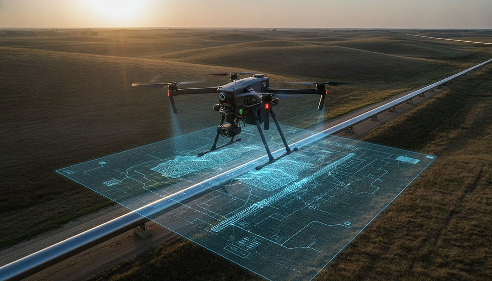
Traditional radar architectures are increasingly inadequate for securing the nearly one million registered drones currently operating within the United States. The successful March 19, 2026, demonstration of Lockheed Martin Project Netsense 5G Network Detection FAA DETER AI Monitoring confirms that 5G infrastructure is transitioning from a mere communication utility into a strategic sensing layer. This evolution addresses the critical vulnerabilities of unauthorized drone intrusions in complex urban environments where legacy systems often fail to provide granular oversight. By utilizing Integrated Sensing and Communication (ISAC), this prototype system transforms existing telecommunications hardware into a comprehensive aerial surveillance network.
Professional security stakeholders recognize that legacy detection methods lack the precision required for high stakes industrial oversight and enterprise protection. This analysis provides an authoritative examination of how NetSense leverages advanced infrastructure to redefine airspace security through autonomous data processing. It delivers a comprehensive understanding of 5G enabled detection and a strategic roadmap for integrating AI monitoring into existing security stacks. The following technical breakdown explores how these technological advancements align with national airspace safety standards, specifically considering the implications of the FAA's DETER program effective April 16, 2026.
Key Takeaways
Examine the transition of commercial 5G infrastructure into a strategic sensing layer under 5G.MIL programs designed to replace traditional, hardware-heavy radar systems.
Analyze the technical architecture of Lockheed Martin Project Netsense 5G Network Detection FAA DETER AI Monitoring to evaluate its role in real-time signal anomaly detection using the STAR.UI interface.
Evaluate the regulatory alignment between advanced detection prototypes and the FAA's April 2026 DETER framework for enhanced airspace enforcement and Remote ID compliance.
Assess the strategic value of integrating software-defined sensing into existing enterprise security stacks for the protection of high-value industrial assets like pipelines and power grids.
Identify how AI-driven airspace intelligence improves the fidelity of infrastructure digital twins and technical geospatial data analysis within complex aerial environments.
The Genesis of AI Monitoring Project NetSense 5G AI Sensing Layer as a Scalable Strategy
Project NetSense represents a paradigm shift in aerial surveillance, moving away from capital-intensive, localized hardware toward a software-defined sensing model. As a prototype system demonstrated by Lockheed Martin on March 19, 2026, NetSense utilizes existing commercial 5G infrastructure to identify and track unmanned aerial vehicles (UAVs). This approach is a core component of the 5G.MIL program, which seeks to integrate military-grade capabilities into ubiquitous telecommunications networks. By repurposing the electromagnetic environment already present in urban centers, the Lockheed Martin Project Netsense 5G Network Detection FAA DETER AI Monitoring initiative establishes a persistent, wide-area detection layer without the logistical burden of deploying dedicated radar arrays.
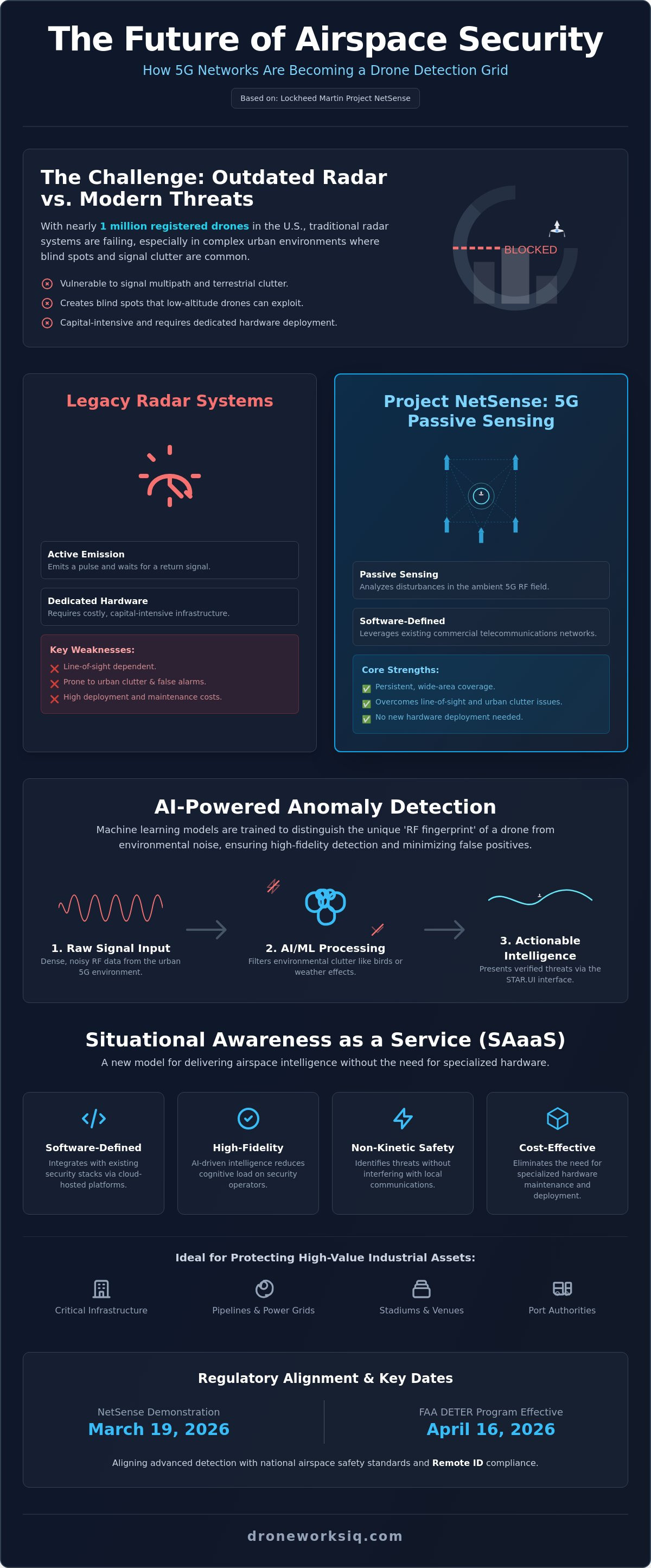
Traditional radar systems frequently encounter performance degradation in high-density urban corridors due to signal multipath and terrestrial clutter. Buildings, heavy traffic, and complex topography create blind spots that small, low-altitude drones can exploit. NetSense mitigates these limitations by leveraging the density of 5G cell sites. This system functions as an extension of the Sanctum™ Counter-UAS ecosystem, providing the initial detection and tracking phase required for comprehensive airspace management. It creates a seamless transition from commercial network monitoring to tactical defense responses through high-speed data processing.
From Communication to Detection: The RF Field Paradigm
The fundamental mechanism of NetSense relies on the analysis of radio frequency (RF) wave propagation within a defined volume. Every 5G tower acts as a constant emitter, creating a dense mesh of ambient signals. When a UAV enters this field, its physical airframe causes specific reflections and signal compressions. NetSense employs passive sensing technology to interpret these disturbances. Unlike active radar that emits a pulse and waits for a return, this passive approach listens to the existing noise and identifies the precise signature of a moving object. Utilizing ubiquitous cellular towers ensures that detection isn't limited by the line-of-sight constraints of a single, localized sensor deployment.
Situational Awareness as a Service (SAaaS)
This technological shift facilitates the emergence of Situational Awareness as a Service (SAaaS), where airspace intelligence is delivered via cloud-hosted platforms. For port authorities, stadium operators, and managers of critical national infrastructure, this model eliminates the need for specialized hardware maintenance. It provides a non-kinetic safety layer that identifies threats without interfering with local communications. The integration of NetSense into enterprise security frameworks allows for automated alerts and real-time data streaming. This ensures that facility managers can maintain comprehensive oversight of their electromagnetic environments while adhering to evolving safety protocols and operational requirements.
AI Monitoring Architecture: Interpreting Signal Anomalies
The operational efficacy of the Lockheed Martin Project Netsense 5G Network Detection FAA DETER AI Monitoring architecture relies on the clinical filtration of ambient electromagnetic interference. AI agents execute high-speed data processing to isolate the discrete signal perturbations caused by mechanical UAV airframes within a dense RF field. These machine learning models are meticulously trained to distinguish between mechanical signatures and biological noise, such as avian flight patterns or wind-blown debris. This differentiation is critical for maintaining high-fidelity situational awareness in congested urban environments where traditional sensors often fail. The system's ability to filter environmental clutter ensures that security teams only respond to verified unauthorized intrusions.
Raw signal data is synthesized and presented through the STAR.UI interface, which functions as the primary hub for mission-relevant visualization. This tool converts complex radio frequency anomalies into simplified, actionable intelligence cues. By prioritizing mission-critical alerts, the system effectively reduces the cognitive burden on security operators who'd otherwise be overwhelmed by raw data streams. This automation ensures that human intervention is reserved for high-stakes tactical responses rather than baseline monitoring tasks. The interface provides a clear operational picture that bridges the gap between raw signal detection and strategic asset protection.
Feature Extraction in 5G RF Environments
Machine learning models utilize advanced feature extraction to identify the specific 'RF fingerprint' associated with diverse drone airframes and propulsion systems. The system analyzes signal reflections, attenuation, and phase shifts as 5G waves interact with various materials like carbon fiber and high-grade plastics. High bandwidth and low latency inherent to 5G networks enable the AI to perform real-time localized tracking with exceptional precision. This level of technical oversight is a prerequisite for sophisticated LiDAR data collection and analysis and other high-precision geospatial workflows where aerial integrity is paramount.
Autonomous Countermeasure Activation
The monitoring architecture facilitates the immediate activation of alert protocols when a confirmed intrusion occurs. AI-driven logic triggers secure notifications to law enforcement and facility security teams without the need for manual input. While the system operates autonomously during the detection and identification phases, it strictly preserves a human-in-the-loop (HITL) protocol for any mitigation actions. This ensures that all responses remain compliant with federal legal frameworks while maximizing the speed of threat identification. This layered approach creates a robust defensive posture for critical infrastructure, ensuring that security personnel can act with detached confidence during an unfolding event.
FAA DETER and the Regulatory Landscape for 2026
The Federal Aviation Administration's activation of the Drone Expedited and Targeted Enforcement Response (DETER) program on April 16, 2026, signifies a definitive shift from voluntary compliance toward high-velocity administrative enforcement. This policy, established in alignment with the "Restoring American Airspace Sovereignty" executive order, streamlines the prosecution of minor drone violations by requiring operators to accept liability within ten days. The Lockheed Martin Project Netsense 5G Network Detection FAA DETER AI Monitoring initiative provides the technical verification layer required to support this accelerated legal framework. While NetSense functions as a prototype sensing utility, its ability to provide persistent oversight creates the evidentiary baseline necessary for federal and municipal authorities to enforce the DETER protocols effectively.
Standardizing detection protocols across disparate law enforcement agencies remains a primary objective for national airspace integrity. Passive RF monitoring through 5G infrastructure avoids the legal complexities associated with active signal jamming or unauthorized packet interception. By analyzing wave propagation rather than private data content, the system identifies airframe signatures without compromising the privacy of ground-based consumer devices. This methodology ensures that the transition to a software-defined National Airspace System (NAS) remains compliant with existing wiretap laws and constitutional privacy protections while simultaneously fulfilling Remote ID requirements.
Regulatory Integration for National Safety
NetSense facilitates a transparent NAS by providing a continuous data stream that validates flight telemetry against authorized flight plans. Enterprise drone operators navigating 5G-monitored zones must ensure their systems maintain strict compliance with evolving data privacy standards. The system's clinical focus on electromagnetic disturbances ensures that signal analysis remains restricted to physical object detection. This technical separation is vital for maintaining public trust while providing the high-level oversight required for complex industrial operations. Compliance is no longer reactive; it's an integrated component of the aerial workflow.
The Future of Restricted Airspace Enforcement
Enforcement of Temporary Flight Restrictions (TFRs) becomes significantly more precise when supported by ubiquitous 5G sensing layers. Proactive airspace management replaces reactive intercept models, allowing authorities to identify potential incursions before they compromise sensitive zones. This transition is essential for the scaling of autonomous logistics corridors and drone-based delivery services. By utilizing FAA-approved detection technologies, municipalities can establish secure aerial transit routes that operate with high-level efficiency. The integration of NetSense-style monitoring into the regulatory stack ensures that restricted airspaces remain impenetrable to unauthorized traffic while supporting authorized commercial growth.
Strategic Implications for Enterprise Infrastructure Protection
Enterprise security managers are transitioning from traditional perimeter defenses toward comprehensive volumetric oversight. The integration of Lockheed Martin Project Netsense 5G Network Detection FAA DETER AI Monitoring provides a high-yield strategic advantage by repurposing existing 5G infrastructure for aerial defense. For critical assets like interstate pipelines and regional power grids, the fiscal impact of unauthorized drone incursions includes operational downtime and severe regulatory penalties. Historical data logging within the NetSense framework facilitates forensic analysis of incursions, effectively reducing liability and insurance premiums for industrial facility operators through documented compliance. This data-driven approach allows for a precise calculation of ROI based on risk mitigation and the avoidance of costly security breaches.
Protecting Enterprise Assets from Aerial Threats
High-value industrial complexes and large-scale construction sites require synchronized security architectures to mitigate emerging risks. NetSense alerts integrate directly with existing Command, Control, Communications, Computers, Intelligence, Surveillance, and Reconnaissance (C4ISR) systems. This synergy provides a unified operational picture that allows security personnel to deploy ground-based response teams with precise coordinates derived from the 5G sensing layer. By maintaining a persistent monitoring environment, enterprises safeguard against industrial espionage and physical sabotage while ensuring the continuity of high-stakes operations. The architecture of the Lockheed Martin Project Netsense 5G Network Detection FAA DETER AI Monitoring ecosystem provides the technical oversight needed to manage complex electromagnetic environments without additional, hardware-intensive sensor deployments.
Operational Deconfliction for Drone Service Providers
Persistent AI monitoring creates a complex environment for authorized unmanned operations. Professional firms like DroneWorksIQ maintain operational integrity by synchronizing mission parameters with active detection networks to prevent false-positive triggers. This deconfliction process is essential during the execution of utility and pipeline inspection services within sensitive industrial corridors. Leveraging detection data from systems like NetSense allows service providers to optimize mission safety by identifying non-participating aircraft in real-time. This coordination ensures that complex geospatial data collection remains efficient and fully aligned with national airspace safety standards. Data transparency between detection systems and service providers facilitates a safer, more predictable aerial environment for all stakeholders. It's a necessary evolution for firms that prioritize technical precision and regulatory adherence.
Integrating Advanced Airspace Intelligence into Geospatial Workflows
The integration of Lockheed Martin Project Netsense 5G Network Detection FAA DETER AI Monitoring into broader industrial workflows represents the next evolution of geospatial data management. By synthesizing real-time RF detection data with high-fidelity spatial models, enterprise operators achieve a level of situational awareness that exceeds traditional static mapping. This synthesis is particularly vital for the maintenance of infrastructure digital twins. These digital assets are no longer just geometric representations; they're dynamic environments that incorporate live security data to reflect the current state of the airspace. High-resolution models benefit from the inclusion of persistent monitoring, ensuring that the physical security of the asset is as well-documented as its structural integrity. This approach allows for the immediate identification of aerial anomalies that could compromise sensitive data collection efforts.
Executive decision-makers require more than raw signal data. They need actionable intelligence that informs risk assessment and resource allocation. AI-driven geospatial analytics transform complex radio frequency disturbances into clear indicators of operational risk. This processing allows for the identification of patterns in unauthorized aerial activity, enabling proactive rather than reactive security postures. DroneWorksIQ bridges the gap between sophisticated aerial data collection and robust airspace security, ensuring that the data harvested during utility or pipeline inspections remains secure and untainted by unauthorized interference. It's a necessary step for organizations that manage high-value infrastructure and require precise oversight.
The Convergence of Mapping and Monitoring
The future of enterprise drone services necessitates a dual-focus approach where high-precision data collection and comprehensive security awareness coexist. Integrating LiDAR and photogrammetry with real-time airspace monitoring data creates a holistic view of national infrastructure projects. This convergence ensures that the data used for digital twinning services is both accurate and protected from external threats. National safety standards increasingly demand this level of oversight for large-scale construction and utility operations. It's a technical requirement for maintaining the integrity of the National Airspace System while scaling autonomous commercial workflows. Organizations that prioritize these integrated workflows are better positioned to handle the complexities of modern industrial environments.
Strategic Consulting for 5G-Enabled Aerial Intelligence
Professional interpretation of complex geospatial and detection datasets is essential for maximizing the utility of 5G sensing layers. Advancing from basic drone mapping to holistic infrastructure intelligence requires specialized expertise in data science and autonomous systems. Organizations must navigate the transition from disparate sensor inputs to a unified, AI-enhanced operational picture. Strategic consulting ensures that these sophisticated technologies are correctly implemented to meet specific industrial outcomes. Analyzing these datasets requires a sophisticated understanding of both RF propagation and spatial analysis. AI-driven geospatial analytics can transform your enterprise oversight from a series of reactive measures into a streamlined, proactive intelligence framework.
Future-proofing Airspace Intelligence and Enterprise Security
The transition toward software-defined sensing layers represents a permanent shift in how national airspace is managed and protected. The successful integration of Lockheed Martin Project Netsense 5G Network Detection FAA DETER AI Monitoring demonstrates that ubiquitous commercial infrastructure can deliver the persistent oversight required for modern industrial security. As the FAA DETER framework accelerates enforcement protocols, enterprises must adopt sophisticated monitoring architectures to mitigate liability and maintain operational continuity. This evolution requires a precise alignment between raw signal intelligence and high-fidelity geospatial data analysis to ensure the integrity of critical infrastructure assets.
DroneWorksIQ provides the technical expertise necessary to navigate this complex technological landscape. As a leading provider of enterprise LiDAR and infrastructure intelligence, the firm offers national coverage for large-scale industrial data collection and advanced analysis. Organizations can leverage specialized expertise in AI-driven geospatial analytics to transform raw detection data into strategic operational insights. Contact DroneWorksIQ for Strategic Geospatial Consulting to integrate these advanced capabilities into your security stack. Implementing these robust solutions ensures that your enterprise remains resilient and fully compliant in an increasingly monitored aerial environment.
Frequently Asked Questions
What is Lockheed Martin's Project NetSense?
Lockheed Martin's Project NetSense is a software-defined prototype system designed to repurpose commercial 5G infrastructure for persistent aerial surveillance. This technology, successfully demonstrated on March 19, 2026, identifies unmanned aerial vehicles by analyzing disturbances in ambient radio frequency fields. It functions as a non-kinetic sensing layer that integrates military-grade detection capabilities into existing telecommunications hardware to provide wide-area situational awareness for enterprise and government stakeholders.
How does 5G network detection differ from traditional drone radar?
5G network detection utilizes passive sensing technology to monitor ambient cellular wave propagation, whereas traditional radar relies on active, hardware-intensive emitters. This approach leverages the high density of existing cell towers to eliminate blind spots in complex urban corridors where legacy radar often fails. It provides a more scalable and cost-efficient solution for persistent airspace oversight without the requirement for specialized, capital-intensive sensor deployments.
What is the FAA DETER framework and how does it relate to NetSense?
The FAA DETER framework, which the agency activated on April 16, 2026, establishes a streamlined administrative response for drone violations. The Lockheed Martin Project Netsense 5G Network Detection FAA DETER AI Monitoring architecture serves as a technical verification layer that supports this regulatory policy. Authorities utilize the data generated by NetSense to provide the evidentiary basis for enforcement actions under the DETER program's accelerated ten-day settlement timeline.
Can NetSense detect drones that are not connected to the cellular network?
NetSense detects drones regardless of their cellular connectivity by analyzing the physical reflection of 5G signals off the UAV airframe. This passive radar methodology identifies any physical object within the RF field that matches a mechanical drone signature. It's specifically engineered to track non-cooperative aircraft that don't broadcast Remote ID signals or maintain active network links for data transmission during flight.
What are the primary applications for AI-monitored 5G drone detection?
Primary applications involve the protection of high-value industrial assets such as power grids, pipelines, and large-scale construction sites. The system provides real-time alerts for stadium security and port authorities to mitigate the risk of aerial sabotage or unauthorized surveillance. It facilitates Situational Awareness as a Service (SAaaS) for enterprise entities requiring persistent oversight of their electromagnetic environments and critical infrastructure assets.
How do enterprise drone operators ensure compliance in NetSense-monitored airspaces?
Enterprise operators ensure compliance by validating all flight telemetry against authorized mission parameters and maintaining active Remote ID broadcasts. Coordination with local security stakeholders is essential to prevent automated systems from flagging legitimate industrial operations as threats. Professional firms utilize high-precision geospatial analytics to document flight paths and maintain a transparent operational record that aligns with national airspace safety standards.
Does NetSense pose a privacy risk to mobile phone users?
Project NetSense doesn't pose a privacy risk because it monitors the physical behavior of radio waves rather than the content of data transmissions. The system's AI agents focus exclusively on signal attenuation and phase shifts caused by physical objects within the network's volume. It ignores the encrypted data packets used for consumer mobile communications, ensuring strict adherence to federal wiretap and privacy laws.
What role does AI play in interpreting RF signal disruptions for drone tracking?
AI executes the clinical filtration of environmental noise to isolate the specific RF fingerprint of a mechanical UAV airframe. Machine learning models perform high-speed data processing to differentiate between drones, avian flight patterns, and wind-blown debris. This automated interpretation is presented through the STAR.UI interface, allowing security personnel to act on mission-relevant alerts with minimal cognitive load during high-stakes monitoring events.