FAA World Cup UAS Measures & DETER Security Explained
- Dan

- Jun 11
- 12 min read
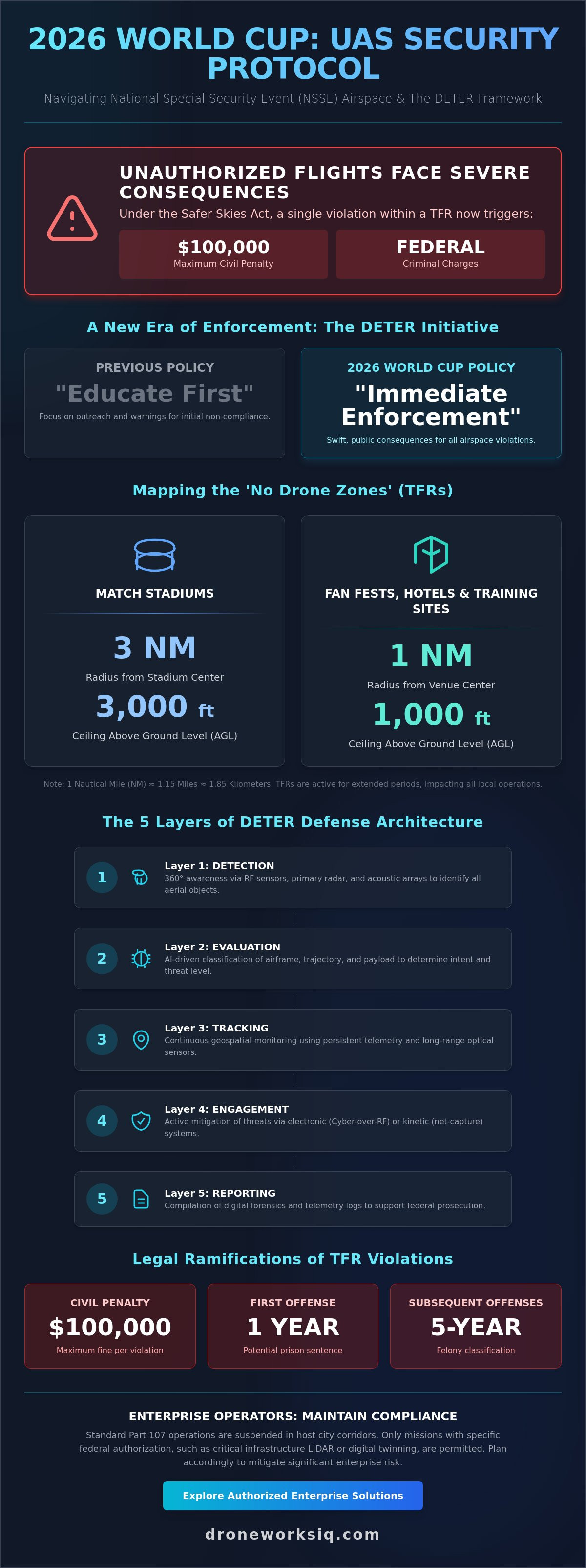
A single unauthorized flight within a 2026 World Cup Temporary Flight Restriction (TFR) now carries a potential $100,000 fine and federal criminal charges under the Safer Skies Act. This shift from educational outreach to immediate enforcement necessitates a comprehensive understanding of the World Cup FAA UAS Measures and DETER Security Layers explained within the context of large-scale event oversight. The FAA's Drone Expedited and Targeted Enforcement Response (DETER) initiative, launched in April 2026, represents a systemic pivot toward swift, public consequences for airspace violations, moving beyond the traditional "educate first" policy that previously defined the agency's stance on recreational and commercial non-compliance.
Enterprise operators recognize that navigating high-stakes environments requires more than basic situational awareness; it demands a technical grasp of multi-agency mitigation protocols. This analysis provides an authoritative breakdown of the current regulatory framework, detailing the specific radius and ceiling parameters governing stadium, hotel, and fan festival zones. We examine the integration of kinetic net-capture systems and Cyber-over-RF solutions that form the sophisticated security apparatus protecting these venues. You'll gain the technical clarity required to maintain compliance and understand the multi-layered enforcement mechanisms active throughout the tournament.
Key Takeaways
Identify the legal ramifications of National Special Security Event (NSSE) designations and the specific 3-nautical-mile radius governing stadium Temporary Flight Restrictions.
Analyze the World Cup FAA UAS Measures and DETER Security Layers explained to understand the transition from passive monitoring to active multi-agency enforcement protocols.
Mitigate enterprise risk by identifying the cessation of standard Part 107 operations within host city corridors and the resulting liabilities for unauthorized infrastructure mapping.
Evaluate the technical integration of Remote ID and long-range thermal imaging used by federal task forces for real-time identification and nighttime enforcement.
Utilize authorized mission profiles for LiDAR data collection and digital twinning to maintain critical infrastructure intelligence without compromising regulatory compliance.
Regulatory Architecture: FAA TFRs and NSSE Designations
The 2026 World Cup operates under a high-security mandate designated as a National Special Security Event (NSSE). This classification transforms the surrounding airspace into a strictly controlled environment where standard FAA regulations for UAS are superseded by emergency federal oversight. The World Cup FAA UAS Measures and DETER Security Layers explained in this section reveal a hierarchical command structure. The Secret Service serves as the lead agency for design and planning, while the FBI manages crisis response and the FAA maintains tactical control over the National Airspace System. Unlike routine Temporary Flight Restrictions (TFRs), these measures grant federal agencies expanded legal leverage to intercept and neutralize potential threats without the typical delays associated with administrative review.
Spatial Boundaries of 'No Drone Zones'
The technical footprint of these restrictions is precise and non-negotiable. For all match venues, the FAA implements a 3-nautical-mile radius extending from the stadium center, with a vertical ceiling of 3,000 feet above ground level (AGL). These zones prohibit all unauthorized aircraft, including small unmanned systems. Secondary restrictions apply to fan festivals, team hotels, and training facilities, establishing a 1-nautical-mile radius and a 1,000-foot AGL ceiling. Temporal activation is equally rigorous. TFRs for stadiums engage several hours before a match and remain active until the venue is cleared. For fan festivals, some TFRs will remain active continuously for several weeks, significantly impacting local enterprise data collection and utility inspections in host city corridors.
NSSE Legal Authorities and Enforcement
NSSE status fundamentally alters the enforcement landscape by expanding federal powers for UAS detection and mitigation. This designation allows the Department of Homeland Security to deploy advanced counter-UAS technologies, such as kinetic net-capture systems, that are generally restricted in civilian areas. The Safer Skies Act, enacted in December 2025, provides the legislative teeth for these operations. Violators of these TFRs face civil penalties reaching $100,000 and the potential for federal criminal charges. A first-time offense can result in a one-year prison sentence, while subsequent violations are classified as five-year felonies. The Department of Justice oversees these prosecutions, emphasizing a shift from educational outreach to a policy of immediate, public accountability. This enforcement posture is designed to protect both participants and critical infrastructure from the risks of unauthorized aerial activity.
FAA World Cup UAS Measures & DETER Security: Decoding DETER Security Architecture: The Five Layers of Defense
The 2026 World Cup serves as the inaugural large-scale application of the Drone Expedited and Targeted Enforcement Response (DETER) program. This framework establishes a systematic approach to counter-UAS operations, shifting from manual observation to a multi-layered, sensor-fused architecture. The FAA World Cup Drone Rules facilitate a tiered defensive strategy where technical identification precedes active mitigation. Within this context, the World Cup FAA UAS Measures and DETER Security Layers explained below represent the current standard for securing high-density civilian environments through five distinct operational phases:
Layer 1: Detection – Deployment of RF sensors, primary radar, and acoustic arrays to achieve 360-degree situational awareness.
Layer 2: Evaluation – AI-driven classification of airframe types and intent based on flight trajectory and payload profiles.
Layer 3: Tracking – Continuous geospatial monitoring via persistent telemetry links and long-range optical sensors.
Layer 4: Engagement – Active electronic or kinetic mitigation of unauthorized aircraft within the TFR perimeter.
Layer 5: Reporting – Compilation of digital forensics and telemetry logs to support federal prosecution and regulatory documentation.
Detection and Evaluation Protocols
Detection begins with RF spectrum analysis to identify control links and triangulate operator coordinates in real time. While Remote ID (RID) provides a baseline for cooperative targets, primary radar is essential for detecting 'dark' drones that lack active broadcasting hardware. AI-driven geospatial analytics distinguish legitimate enterprise missions, such as authorized drone mapping and photogrammetry services, from non-compliant incursions by comparing flight paths against pre-approved mission parameters. This automated classification reduces the cognitive load on security personnel, allowing for a rapid transition from detection to tracking without the delays of manual verification.
Engagement and Mitigation Technologies
Mitigation strategies for the 2026 World Cup emphasize non-destructive takeover and kinetic containment to protect spectators on the ground. Electronic mitigation involves signal jamming and protocol manipulation, often referred to as spoofing, to sever the operator's control. Kinetic engagement utilizes systems like the DroneHunter hexcopter, which deploys nets to physically capture and relocate unauthorized UAS. The 'forced landing' protocol, enabled by Sentrycs’ Cyber-over-RF (CoRF) technology, allows authorities to seize control of an aircraft's navigation system and execute a safe landing at a predetermined secure location. These technologies ensure that unauthorized aircraft are neutralized with clinical precision, maintaining the integrity of the National Security Special Event without introducing secondary risks to the public.
Enterprise Implications: Navigating Commercial Compliance
The implementation of National Special Security Event (NSSE) protocols necessitates a total cessation of standard Part 107 operations within host city corridors. For infrastructure managers, the World Cup FAA UAS Measures and DETER Security Layers explained throughout this analysis dictate a shift in operational risk assessment. Unauthorized mapping or inspection flights aren't simple regulatory infractions; they represent significant liabilities that trigger immediate federal intervention. Real-time TFR data acquisition via the B4UFLY application and the FAA DroneZone portal is now a mandatory prerequisite for any aerial mission profile in the vicinity of match venues. Failure to synchronize flight schedules with active TFR windows exposes enterprises to the risk of equipment seizure and federal prosecution under the Safer Skies Act.
Infrastructure Risk Mitigation
The disruption of recurring utility and pipeline inspection services requires immediate strategic recalibration. Passive detection systems integrated into the DETER framework frequently flag legitimate surveying equipment, such as high-precision LiDAR sensors, if they operate without verified digital handshakes. This creates a technical friction point where authorized erosion monitoring services or agri-health mapping might be interpreted as hostile incursions. Managers must prioritize mission scheduling outside of restricted windows or seek specific waivers to ensure continuity. The deployment of facade inspection services on critical urban infrastructure must be coordinated with local Ground Intercept Teams (GIT) to prevent accidental engagement by counter-UAS assets.
Credentialing and Special Authorization
Operating within a high-security zone during the World Cup requires a Special Government Interest (SGI) waiver. This process isn't a routine authorization; it involves a rigorous vetting protocol where federal agencies evaluate the pilot's credentials and the mission's criticality. Documentation requirements for essential infrastructure data collection include detailed flight paths, specific airframe serial numbers, and proof of Remote ID compliance. Federal agencies conduct comprehensive background checks on all commercial personnel seeking access to restricted airspace. This level of oversight ensures that only verified enterprise partners maintain operational intelligence while the surrounding airspace remains locked down for public safety. Coordination should begin several months prior to the tournament to account for the anticipated administrative backlog.
Technical Countermeasures: Detection to Interception
The integration of Remote ID (RID) serves as the primary technical layer for distinguishing authorized enterprise assets from non-compliant incursions. Within the context of the World Cup FAA UAS Measures and DETER Security Layers explained, RID acts as a persistent digital handshake. It allows security task forces to cross-reference broadcasted telemetry against pre-approved mission profiles in real time. For nighttime enforcement, authorities deploy long-range thermal imaging and optical tracking arrays that provide high-fidelity visual verification of airframes even when lighting conditions are suboptimal. Signal intelligence (SIGINT) capabilities further augment this by localizing the Ground Control Station (GCS), enabling ground teams to intercept operators before a flight mission concludes.
The evolution of Counter-UAS (C-UAS) technology has moved rapidly from military theaters to domestic sporting applications. This transition involves the deployment of sophisticated electronic warfare suites designed for surgical precision in high-density civilian areas. Unlike broad-spectrum jamming, these systems utilize protocol manipulation to isolate and neutralize specific control links without disrupting local cellular or emergency communications. This surgical approach is essential for maintaining the operational integrity of critical infrastructure while securing the stadium perimeter against unauthorized aerial activity.
Remote ID and Broadcast Requirements
RID is a non-negotiable requirement for all operations within the National Special Security Event (NSSE) perimeter. It facilitates immediate aircraft identification and intent evaluation, reducing the probability of accidental engagement by kinetic countermeasures. Operating a UAS without active RID broadcasts during the tournament constitutes a Tier-1 security violation, often resulting in immediate signal disruption or physical capture. Technical limitations exist in these environments. High-congestion RF zones in urban host cities can lead to signal attenuation or packet loss. Enterprise teams must ensure their hardware is optimized for high-interference environments to maintain a consistent digital signature.
Advanced Mitigation Forensics
The conclusion of an interception event initiates a multi-agency forensic protocol. Data extraction from seized UAS hardware allows the FBI and FAA to identify operators and reconstruct flight logs with granular precision. This process uncovers geofencing bypass attempts, which serve as critical evidence of criminal intent in federal court proceedings. Technical analysis of onboard storage and control links helps authorities map the broader threat landscape and refine future mitigation strategies. For organizations requiring precise data in these complex environments, partnering with experts in LiDAR data collection and analysis ensures that all technical and regulatory parameters are met with clinical accuracy. This collaboration between the FAA and FBI ensures that every unauthorized flight has a documented technical trail, reinforcing the shift toward absolute accountability.
DroneWorksIQ: Strategic Aerial Intelligence in Restricted Environments
DroneWorksIQ positions itself as the primary strategic partner for organizations requiring sophisticated aerial intelligence within high-security perimeters. The World Cup FAA UAS Measures and DETER Security Layers explained throughout this analysis create a complex operational environment where technical precision is mandatory. We operate at the intersection of advanced sensor technology and strategic industrial application, providing a bridge between critical infrastructure requirements and the rigorous constraints of National Special Security Events. Our methodology prioritizes data-driven results over speculative operations, ensuring that every authorized mission aligns with federal mitigation standards and maintains the integrity of the National Airspace System.
Enterprise Data Collection Standards
We maintain a methodical approach to LiDAR data collection and analysis during active TFR windows. This involves the precise synchronization of flight telemetry with federal detection systems to ensure a constant digital handshake. Our technical teams manage the administrative burden of SGI waiver documentation and Remote ID verification, allowing infrastructure managers to focus on actionable results rather than regulatory friction. Beyond LiDAR, we utilize high-resolution drone mapping and photogrammetry services to document site conditions with clinical accuracy. We ensure data integrity by utilizing high-fidelity sensors that operate effectively in the high-interference RF environments characteristic of urban host cities. This rigor extends to facade inspection services for high-value urban assets, where proximity to restricted zones requires absolute control and pre-coordinated mission profiles.
Geospatial Consulting for High-Stakes Projects
Professional interpretation of complex geospatial data is essential for maintaining large-scale utility and pipeline inspection services. Our implementation of AI-driven geospatial analytics enhances asset oversight during high-security periods by automating the identification of structural anomalies within massive datasets. This level of autonomous intelligence allows for national-scale asset protection without the risks associated with manual data processing. We integrate these insights into digital twinning services to provide a persistent, high-resolution model of critical infrastructure. Such models are vital for construction intel during stadium expansions or urban renovations occurring near restricted venues. By leveraging the World Cup FAA UAS Measures and DETER Security Layers explained in our consulting framework, we provide organizations with the technical depth required to navigate the 2026 World Cup landscape while maintaining absolute regulatory compliance and operational continuity.
Securing Operational Continuity in High-Stakes Airspace
The 2026 World Cup represents a paradigm shift in domestic airspace management, moving from passive monitoring to an active, multi-layered enforcement posture. Success for enterprise entities depends on a precise understanding of the World Cup FAA UAS Measures and DETER Security Layers explained throughout this analysis. Navigating these restrictions requires more than basic compliance; it demands a technical infrastructure capable of maintaining digital handshakes with federal task forces. Organizations must prioritize mission scheduling and rigorous documentation to avoid the severe liabilities associated with National Special Security Event violations.
Maintaining infrastructure intelligence during these high-security windows is achievable with the right strategic partner. DroneWorksIQ provides the authoritative expertise required to execute complex missions within restricted environments. Our specialization in national-scale infrastructure inspections, combined with advanced LiDAR and AI-driven geospatial analytics, ensures that your data collection remains uninterrupted and legally sound. It's time to partner with DroneWorksIQ for authorized enterprise aerial intelligence. Secure your operational continuity and leverage sophisticated data solutions to navigate this complex regulatory landscape with confidence.
Frequently Asked Questions
What exactly is a 'No Drone Zone' for the 2026 World Cup?
A 'No Drone Zone' is a Temporary Flight Restriction (TFR) established under National Special Security Event (NSSE) status to secure the National Airspace System. For 2026 World Cup stadiums, this zone encompasses a 3-nautical-mile radius and a 3,000-foot ceiling above ground level. Fan festivals and team base camps operate under smaller TFRs with a 1-nautical-mile radius and a 1,000-foot ceiling. These restrictions prohibit all unauthorized aircraft, including small unmanned systems, to ensure public safety and operational security.
Can commercial Part 107 pilots fly in World Cup TFRs with a waiver?
Standard Part 107 operations are suspended within active TFR boundaries; however, pilots can request a Special Government Interest (SGI) waiver for critical missions. This process requires significant lead time and involves rigorous federal vetting of the pilot's credentials and mission profile. Authorization is typically reserved for public safety, media, or essential infrastructure oversight. Pilots must maintain persistent digital handshakes with federal task forces and adhere to strict Remote ID broadcast requirements throughout the flight duration.
What are the specific layers of the DETER security framework used by the FAA?
The World Cup FAA UAS Measures and DETER Security Layers explained in this framework consist of five tactical phases: Detection, Evaluation, Tracking, Engagement, and Reporting. This systematic architecture utilizes sensor fusion to identify airframes, classify their intent via AI-driven analytics, and monitor geospatial telemetry in real time. If a threat is confirmed, authorities transition to engagement protocols, which include electronic takeover or kinetic mitigation, followed by comprehensive forensic reporting to support federal prosecution and regulatory documentation.
What are the penalties for flying a drone near a World Cup stadium in 2026?
Unauthorized flights within a World Cup TFR carry civil penalties of up to $100,000 per violation and the risk of immediate equipment confiscation. Under the Safer Skies Act of 2025, operators also face federal criminal charges, which can result in a one-year prison sentence for a first-time offense. Subsequent violations are prosecuted as five-year felonies. These stringent consequences reflect a shift toward absolute accountability and immediate enforcement to protect high-density civilian environments during National Special Security Events.
How do authorities detect unauthorized drones during National Security Events?
Authorities utilize a multi-layered sensor suite that integrates RF spectrum analysis, primary and secondary radar, and acoustic arrays to achieve 360-degree situational awareness. This system identifies control links and triangulates operator coordinates even if the aircraft isn't broadcasting a Remote ID signal. Optical and thermal sensors provide long-range visual verification, allowing Ground Intercept Teams to classify airframes and evaluate potential payloads. This fused data environment ensures that 'dark' drones are localized and tracked before they penetrate the inner stadium perimeter.
Does the 2026 World Cup drone restriction apply to team training facilities?
Yes, the FAA establishes TFRs around team hotels and practice sites to maintain a secure perimeter for participants. These restrictions typically feature a 1-nautical-mile radius and a 1,000-foot vertical ceiling. These zones are active relative to team arrivals and training schedules, often remaining in place for several weeks. Enterprise operators must utilize tools like the FAA DroneZone to verify the temporal status of these restrictions, as unauthorized incursions near training sites trigger the same federal enforcement protocols as stadium violations.
What technologies are used for drone interception at the World Cup?
Interception strategies prioritize non-kinetic takeover through Cyber-over-RF (CoRF) technology, which allows authorities to seize control of an unauthorized UAS and execute a safe landing. For persistent threats, kinetic solutions like the DroneHunter hexcopter utilize net-capture systems to physically remove aircraft from the restricted zone. These technologies are selected for their surgical precision, ensuring that unauthorized drones are neutralized without utilizing broad-spectrum jamming that could disrupt local emergency communications or cellular networks in host city corridors.
How can enterprise companies conduct essential infrastructure inspections during the tournament?
Enterprise entities must coordinate with authorized aerial intelligence providers who specialize in navigating World Cup FAA UAS Measures and DETER Security Layers explained within this regulatory context. These missions require pre-approved SGI waivers and a technical commitment to Remote ID transparency. By utilizing high-precision LiDAR and AI-driven geospatial analytics, organizations can maintain critical asset oversight while adhering to federal security protocols. It's essential to begin the coordination process several months before the tournament to ensure all technical and administrative requirements are satisfied.