Navigating 2026 World Cup TFRs for Commercial UAS Pilots
- Dan

- Jun 12
- 12 min read
Updated: Jun 15
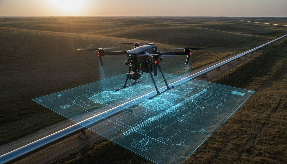
The 2026 World Cup will transform major U.S. metropolitan airspaces into high-security "No Drone Zones," where unauthorized flight carries civil penalties up to $75,000 per violation. For enterprise operators, these month-long flight bans are more than a security measure; they're a direct threat to critical infrastructure monitoring and contractual data delivery timelines. Maintaining project momentum requires an exhaustive understanding of the FAA World Cup Related Festivals sites across the United States in the Summer of 2026 and the TFR restrictions and commerical UAS industry impacts. You likely recognize that project stagnation during these national security events isn't just an inconvenience but a significant liability for industrial data continuity.
This article provides a technical analysis of the Summer 2026 TFR protocols and offers a strategic framework for maintaining commercial aerial data collection during high-security deployments. We'll examine the specific 3-nautical-mile stadium radii and 1-nautical-mile fan festival restrictions that will govern host cities from Seattle to Miami. The following sections detail the Special Governmental Interest (SGI) waiver process, the 72-hour regulatory window for critical infrastructure authorizations, and the logistics of rescheduling large-scale LiDAR and photogrammetry workflows to bypass total operational shutdowns.
Key Takeaways
Identify the technical distinctions between 14 CFR § 91.141 and § 91.145 to navigate the multi-agency security protocols enforced by the FAA, DHS, and DOJ.
Analyze the geographic footprint of FAA World Cup Related Festivals sites across the United States in the Summer of 2026 and the TFR restrictions and commerical UAS industry impacts to quantify precise buffer zones.
Assess the industrial implications of the 40-day "Data Void" on infrastructure monitoring and identify specific bottlenecks in high-resolution LiDAR data collection.
Execute a strategic mitigation plan utilizing the System Operations Support Center (SOSC) to secure Special Government Interest (SGI) waivers for critical utility and pipeline inspections.
Optimize project lifecycles through advanced geospatial consulting and high-efficiency sensor deployment to maximize data yield during narrow, non-restricted flight windows.
Architectural Overview of 2026 World Cup Airspace Security Protocols
The 2026 World Cup security architecture involves a sophisticated, multi-agency coordination matrix between the FAA, Department of Homeland Security (DHS), and Department of Justice (DOJ). This integrated enforcement strategy establishes a high-security environment that prioritizes national safety over standard commercial airspace access. While "No Drone Zones" serve as the public-facing nomenclature, the underlying legal authority rests in Temporary Flight Restrictions (TFRs) issued under 14 CFR § 91.141 and § 91.145. These specific regulatory frameworks allow for the immediate suspension of standard flight operations to protect participants and spectators. Reviewing Prohibited Airspace Explained provides the necessary foundational context for how these temporary mandates override existing Part 107 authorizations. Real-time updates regarding these dynamic volumes are disseminated via Notices to Air Missions (NOTAMs), which serve as the primary technical source for active airspace status.
The geographic density of FAA World Cup Related Festivals sites across the United States in the Summer of 2026 and the TFR restrictions and commerical UAS industry impacts will necessitate rigorous scheduling adjustments for all geospatial service providers. This regulatory landscape isn't merely a set of localized flight bans but a systemic reclassification of urban airspaces across eleven host cities. Commercial pilots must recognize that TFRs under § 91.141 are typically reserved for national security events, meaning they carry significantly higher enforcement priority than standard athletic event restrictions.
The Tiered Restriction Framework
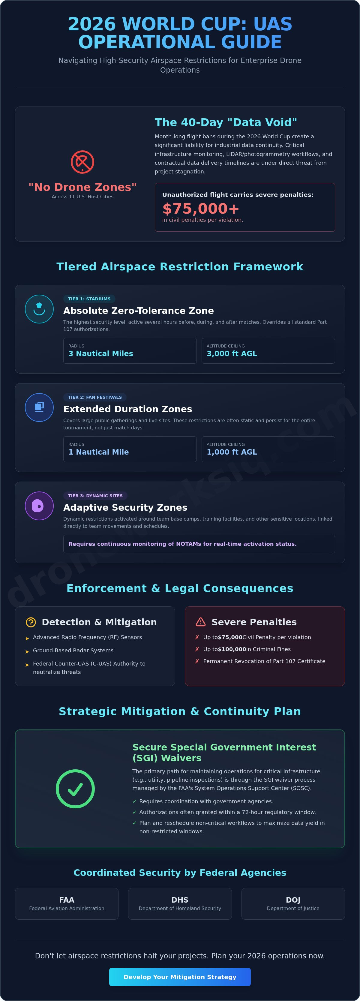
Security protocols utilize a three-tiered spatial model to manage risk across various venue types. Tier 1 zones encompass stadium inner rings, enforcing an absolute zero-tolerance policy within a 3-nautical-mile radius and up to 3,000 feet above ground level during match windows. Tier 2 zones address the extensive footprint of FAA World Cup Related Festivals sites across the United States in the Summer of 2026 and the TFR restrictions and commerical UAS industry impacts, covering a 1-nautical-mile radius and up to 1,000 feet above ground level. Tier 3 restrictions are dynamic, focusing on base camps and training facilities with activations linked directly to team movements and practice schedules.
Enforcement Mechanisms and Legal Consequences
Host venues will deploy advanced UAS detection and mitigation technologies, including radio frequency (RF) sensors and radar systems, to identify unauthorized incursions. Federal agencies possess the authority to utilize electronic counter-UAS (C-UAS) measures to neutralize non-compliant aerial platforms within protected volumes. The legal consequences for incursions are severe. Unauthorized commercial operators face civil penalties up to $75,000 per violation and potential criminal fines reaching $100,000. The FAA also maintains the authority to initiate administrative actions for the permanent revocation of Part 107 remote pilot certificates, effectively terminating an operator's professional capacity.
Geographic Distribution of Summer 2026 UAS Constraints
The 2026 World Cup establishes a distributed airspace security network across eleven primary metropolitan hubs. This national footprint necessitates a precise understanding of the FAA World Cup 2026 Drone Restrictions, which define the operational boundaries for commercial UAS. Stadium-centric TFRs typically encompass a 3-nautical-mile radius, extending from the surface up to 3,000 feet above ground level (AGL). These restrictions activate several hours before kickoff and remain in effect until post-match clearing, creating high-priority no-fly zones that disrupt standard utility and pipeline inspection services. Operators shouldn't assume standard Part 107 rules apply within these volumes; the security protocols override typical commercial authorizations.
Unlike standard sporting event TFRs, the 2026 framework incorporates expanded perimeters for non-stadium sites. Fan festivals and live sites, such as Centennial Olympic Park in Atlanta or Bayfront Park in Miami, trigger 1-nautical-mile TFRs with vertical ceilings of 1,000 feet AGL. As these areas prepare for high-traffic educational and entertainment setups, you might check out Immersive Experiences to see the types of geodesic domes and immersive installations often found at such large-scale events. These zones often persist for the duration of the tournament, unlike match-day-only stadium restrictions. Understanding the density of FAA World Cup Related Festivals sites across the United States in the Summer of 2026 and the TFR restrictions and commerical UAS industry impacts is critical for geospatial planning. Operators must differentiate between these static, long-duration festival zones and the dynamic, event-specific stadium rings to maintain operational continuity.
Festival and Fan Zone Airspace Saturation
Urban infrastructure mapping becomes technically complex when sites are located near 'FIFA Fan Festivals'. These locations, often situated in city centers, create persistent airspace saturation that complicates facade inspection services and construction monitoring. Secondary sites, including designated team hotels and transportation hubs like Seattle’s Pier 62, may also trigger dynamic restrictions based on security intelligence. This saturation requires a proactive approach to risk mitigation. Utilizing professional drone mapping and photogrammetry services allows enterprises to schedule high-priority data collection outside of peak tournament activity windows.
National Airspace System (NAS) Congestion
The influx of manned aviation during the tournament introduces significant separation challenges. Broadcast helicopters, security assets, and VIP transport increase traffic density within the NAS, particularly around metropolitan hubs like Dallas and Los Angeles. This congestion heightens the risk of radio frequency interference, potentially compromising C2 (Command and Control) links for autonomous systems. High-security environments often utilize signal-jamming or mitigation technologies that can degrade GPS reliability. Commercial operators must deploy redundant communication protocols and robust detect-and-avoid (DAA) sensors to ensure safe separation from manned aircraft and maintain system integrity in these electromagnetically dense environments.
Commercial UAS Industry Impacts: LiDAR and Infrastructure Disruption
The imposition of widespread airspace closures creates a significant "Data Void" for enterprise-level infrastructure monitoring. Standardized inspection cycles for critical assets, particularly those situated within high-density metropolitan corridors, face unprecedented disruption during the 40-day tournament window. This temporal gap in geospatial intelligence occurs during the Summer peak-load period for utilities, where thermal anomalies and structural integrity issues require high-frequency oversight. Missing these critical data points isn't a mere scheduling inconvenience; it's a systemic risk to asset management. The global commercial drone market, valued at an estimated $28.87 billion in 2026, relies on consistent access to the National Airspace System (NAS) to maintain these industrial workflows.
The FAA World Cup 2026 Flight Restrictions necessitate a total redistribution of aerial survey efforts. For projects involving the FAA World Cup Related Festivals sites across the United States in the Summer of 2026 and the TFR restrictions and commerical UAS industry impacts, the inability to capture high-resolution terrain data during optimal seasonal windows creates a bottleneck in urban development. Construction progress monitoring relies on precise temporal comparisons. A month-long hiatus in data collection can obscure critical path milestones and lead to unverified structural developments, potentially triggering contractual penalties for data collection delays.
LiDAR and Photogrammetry Accuracy Degradation
Compressed operational timelines often force pilots to operate under sub-optimal lighting or atmospheric conditions to avoid active TFR windows. This results in increased noise within LiDAR point clouds and reduced radiometric accuracy in multispectral imaging. Maintaining drone mapping accuracy enterprise standards requires rigorous post-processing to mitigate artifacts introduced by restricted flight paths and limited loiter times. When sensor pulse repetition rates and scan angles are compromised by altitude or lateral distance requirements, the resulting digital twins may lack the fidelity required for precise engineering analysis.
Supply Chain and Contractual Friction
The inability to access restricted sites triggers force majeure clauses in existing service-level agreements, creating legal friction between UAS service providers and enterprise clients. Drone surveying companies must account for the rising cost of mobilization for night-time or off-peak operations conducted outside TFR windows. Strategic asset reallocation becomes a necessity. Fleets must move to non-host regions to maintain utilization rates while host cities remain under federal airspace control. This shift disrupts the local availability of specialized sensors, such as high-grade LiDAR or gas leak detection units, in the very areas where infrastructure stress is highest due to increased event-related demand.
Strategic Mitigation: Navigating FAA Waivers and Scheduling
Standard Part 107.41 airspace authorizations are typically rescinded or denied when a national security TFR is active. Successful mitigation requires shifting to the Special Government Interest (SGI) process facilitated by the FAA System Operations Support Center (SOSC). This pathway is not accessible through the standard FAADroneZone portal and remains reserved for operations providing direct support to government agencies or critical infrastructure protection. Understanding the proximity of FAA World Cup Related Festivals sites across the United States in the Summer of 2026 and the TFR restrictions and commerical UAS industry impacts is the first step in determining if a project qualifies for this specialized oversight. Enterprise operators must accept that standard commercial waivers are insufficient during these high-security windows.
Proactive scheduling remains the most effective tool for maintaining data continuity. The "Pre-Event Baseline" strategy involves capturing high-resolution LiDAR and photogrammetric data in the weeks preceding the June 11 kickoff. This establishes a ground-truth dataset that can be used for comparative analysis if aerial access is severed. Tactical scheduling exploits the brief operational windows between active TFR pulses. While stadium TFRs are match-day specific, festival zones may be persistent. This necessitates a hybrid approach that combines aerial data with alternative capture methods to bypass total project stagnation. Rapid mobilization during non-restricted hours is essential for maintaining contractual obligations.
The SGI Waiver Application Framework
Petitions for SGI waivers must demonstrate an immediate need for "Critical Infrastructure" protection, such as emergency utility repair or pipeline integrity verification. Sponsorship from a relevant law enforcement agency or government entity is mandatory. Approved flights require strict adherence to coordination protocols, including real-time communication with Air Traffic Control and full Remote ID compliance. Failure to maintain these technical standards results in immediate mission termination. The SOSC prioritizes missions based on life-safety and national security necessity, meaning routine construction progress mapping rarely meets the threshold for approval.
Alternative Data Capture Methodologies
When aerial access remains restricted, operators must transition to ground-based LiDAR and mobile mapping systems to maintain urban facade inspection schedules. High-altitude satellite imagery can supplement missing low-altitude drone data to provide macro-level project overviews. To normalize datasets once restrictions lift, implementing autonomous aerial data collection in the immediate post-event window is essential. This ensures that the longitudinal integrity of the geospatial record is preserved despite the 40-day airspace disruption. For advanced project planning and TFR risk assessment, consult with our technical operations team to secure your 2026 data pipeline.
DroneWorksIQ: Ensuring Data Continuity Amid Airspace Complexity
DroneWorksIQ operates at the intersection of regulatory compliance and high-fidelity geospatial intelligence. As the FAA World Cup Related Festivals sites across the United States in the Summer of 2026 and the TFR restrictions and commerical UAS industry impacts redefine the National Airspace System, we provide the tactical consulting required to maintain operational stability. We deploy high-efficiency LiDAR and thermal sensors specifically configured to maximize data yield within the narrow, non-restricted windows identified in previous sections. This involves utilizing high-pulse-rate sensors that maintain point density even at increased ground speeds, allowing for rapid mission completion. Our national-scale mobilization capabilities allow us to circumvent regional bottlenecks by reallocating specialized UAS fleets to non-host hubs, ensuring that utility and pipeline inspection services remain uninterrupted across the broader domestic grid.
The complexity of the 2026 tournament requires more than just pilot skill; it demands a sophisticated data architecture. We focus on the systematic capture and analysis of geospatial information, ensuring that the temporary suspension of flight operations doesn't result in a permanent loss of asset intelligence. By prioritizing high-yield sensor deployments, we maximize the volume of actionable data collected during every authorized flight hour.
Sophisticated Infrastructure Intelligence
We process raw sensor data into actionable intelligence through a methodical pipeline designed for high-stakes industrial environments. When physical access is prohibited by federal TFRs, we utilize existing high-resolution datasets to generate comprehensive digital twins, enabling virtual inspections that sustain predictive maintenance schedules. The integration of AI-driven geospatial analytics allows for the interpolation of structural trends, bridging the 40-day temporal gaps caused by flight bans. Our algorithms detect subtle changes in asset condition by comparing pre-event baselines with post-event captures, ensuring that no degradation goes unnoticed during the tournament hiatus. This approach effectively transforms the temporary "Data Void" into a manageable variable within a larger, data-driven asset management strategy.
Enterprise Partnership for Regulatory Resilience
DroneWorksIQ provides corporate decision-makers with a definitive roadmap for 2026 aerial data strategy. We don't offer generic safety warnings; we provide a clinical analysis of how specific TFR volumes intersect with your critical infrastructure footprint. Our commitment to authoritative data standards ensures that every LiDAR point cloud and photogrammetric model meets the rigorous requirements of the geospatial and engineering sectors. We provide the technical depth required to build trust in high-tech environments where precision is non-negotiable. Organizations requiring sophisticated data continuity should contact DroneWorksIQ for a strategic audit of your 2026 infrastructure mapping schedule to ensure technical continuity during this period of unprecedented airspace complexity.
Strategic Resilience in High-Security Airspace
The 2026 World Cup necessitates a paradigm shift in urban airspace management, requiring enterprise operators to transition from reactive compliance to proactive geospatial intelligence. Successful industrial operations depend on a granular understanding of the FAA World Cup Related Festivals sites across the United States in the Summer of 2026 and the TFR restrictions and commerical UAS industry impacts. By integrating tiered restriction awareness with the Special Government Interest (SGI) waiver process, organizations can effectively mitigate the risks of project stagnation and contractual data delivery penalties. Digital twinning and AI-driven predictive analytics further ensure that infrastructure monitoring remains robust even when physical aerial access is temporarily suspended by federal mandate.
DroneWorksIQ provides the technical depth and national-scale mobilization capabilities required to navigate these complexities with clinical precision. Our specialized LiDAR and photogrammetry expertise, supported by an AI-driven geospatial intelligence platform, empowers stakeholders to maintain high-fidelity data streams throughout the tournament window. Schedule a Strategic Consultation for Your 2026 Aerial Data Continuity Plan to secure your project timelines against federal airspace constraints. Precision planning transforms regulatory obstacles into manageable operational variables.
Frequently Asked Questions
Will commercial drone pilots be allowed to fly near World Cup stadiums with a Part 107 license?
Standard Part 107 remote pilot certificates don't authorize entry into active national security TFRs. These restrictions establish prohibited volumes that supersede standard commercial flight permissions during the tournament. Unauthorized entry during match windows results in immediate enforcement action regardless of pilot certification status or previous airspace authorizations. Operators must secure an SGI waiver for any flight within these designated security perimeters.
How long do the 2026 World Cup TFR restrictions typically last at each site?
Stadium TFR durations align with specific match schedules, typically activating several hours before kickoff and terminating after spectator egress. Conversely, FAA World Cup Related Festivals sites across the United States in the Summer of 2026 and the TFR restrictions and commerical UAS industry impacts often maintain persistent restrictions for the tournament's full 40-day duration. Pilots must verify specific activation times through official NOTAMs for each host city.
Can I apply for a waiver to perform critical utility inspections inside a World Cup TFR?
Critical infrastructure inspections require a Special Government Interest (SGI) waiver issued by the FAA System Operations Support Center (SOSC). Applicants must demonstrate an immediate necessity for utility or pipeline integrity verification and secure sponsorship from a relevant government or law enforcement agency. Routine commercial surveying or construction monitoring doesn't meet the high threshold for SGI approval during these national security events.
What is the radius of the 'No Drone Zones' for the 2026 World Cup Fan Festivals?
Fan Festival zones utilize a 1-nautical-mile radius from the event epicenter with a vertical ceiling of 1,000 feet above ground level. This footprint is smaller than the 3-nautical-mile radius and 3,000-foot ceiling enforced at primary stadium venues during match operations. Despite the smaller radius, these zones are often persistent and create significant bottlenecks for urban facade inspection services and local infrastructure mapping.
How will the FAA detect unauthorized drone flights during the tournament?
The FAA and DHS deploy integrated detection matrices including radio frequency scanners and radar arrays to identify UAS signatures. These systems provide real-time telemetry and pilot location data to federal enforcement teams, enabling rapid mitigation of unauthorized aerial platforms. Detection capabilities extend across the full volume of the TFR, ensuring that any non-compliant C2 link or GPS signature is identified immediately upon takeoff.
Will the 2026 World Cup TFRs affect drone flights in residential areas far from stadiums?
Restrictions apply only to airspaces within the specified radii of stadiums, festivals, or team base camps. However, the geographic density of FAA World Cup Related Festivals sites across the United States in the Summer of 2026 and the TFR restrictions and commerical UAS industry impacts ensures many urban residential areas fall under persistent flight bans. Operators should use geospatial tools to verify if their project coordinates intersect with these localized buffer zones.
What are the penalties for flying a drone in a World Cup TFR zone?
Violations trigger civil penalties reaching $75,000 per occurrence and potential criminal fines up to $100,000. Federal authorities possess the legal mandate to confiscate UAS hardware and initiate administrative proceedings for the permanent revocation of the operator's Part 107 certificate. Criminal prosecution is possible if the flight is deemed a threat to national security or public safety under 14 CFR § 91.141.
How can I check the real-time status of TFRs during the Summer of 2026?
Operators must monitor the official FAA TFR website and active Notices to Air Missions (NOTAMs) for real-time airspace status. Relying solely on third-party applications is discouraged for high-stakes compliance in high-security environments. Direct verification through the FAA System Operations Support Center (SOSC) or the official FIFA World Cup 2026 Flight Advisory provides the most authoritative data for mission planning and risk mitigation.