
Drone Cell Tower Inspection Safety, Savings, and Quality
- Dan
- Jun 16
- 6 min read
The Paradigm Shift in Telecom Asset Management
Drone cell tower inspection represents the systematic deployment of Unmanned Aerial Vehicles (UAVs) for comprehensive vertical asset integrity management. This technological evolution marks a definitive departure from conventional, high-risk inspection methodologies. Where manual tower climbs by rope-access technicians were once the industry standard, autonomous aerial data acquisition now provides a safer, faster, and more data-rich alternative. The integration of high-resolution sensors, including photogrammetry cameras and LiDAR scanners, is fundamental to maintaining the structural integrity and operational uptime of national telecommunications infrastructure. The core transition is not merely one of perspective, but a fundamental shift from subjective visual observation to the objective acquisition of geospatial data for the creation of high-fidelity digital twins.
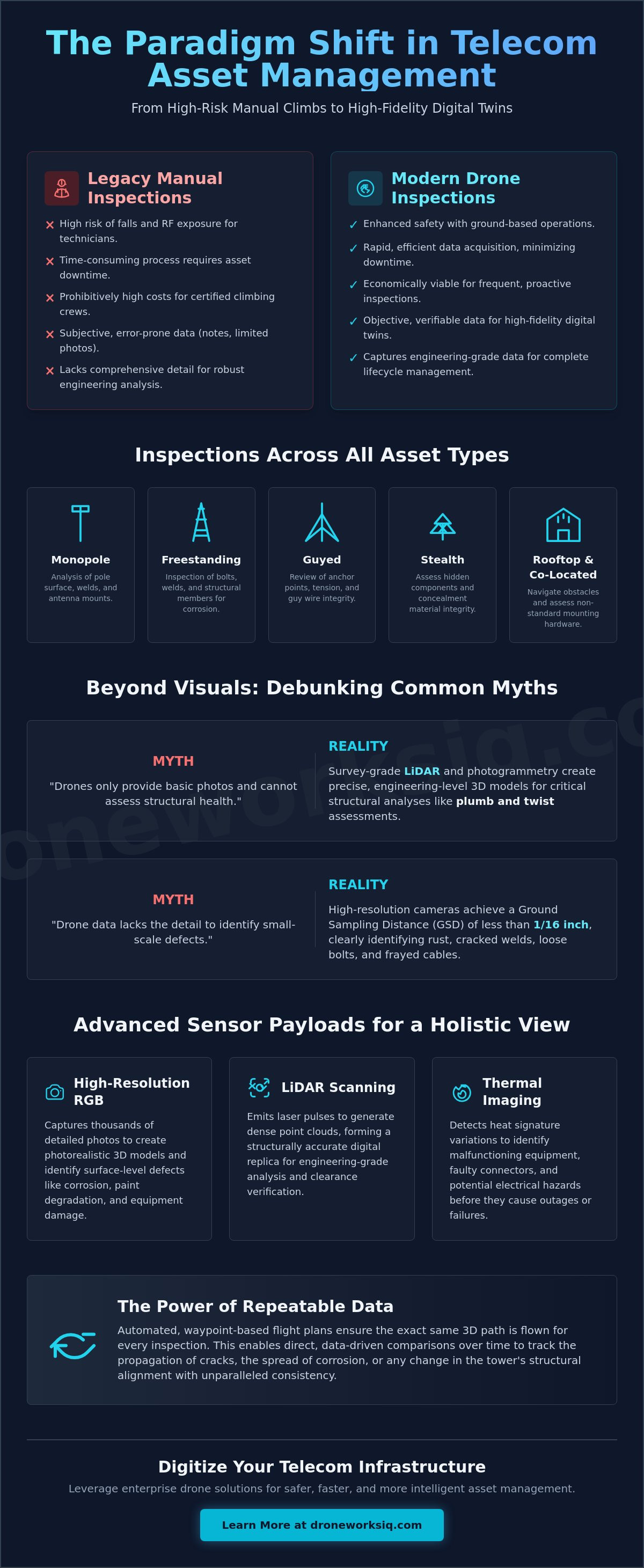
This advanced approach offers a scalable solution for managing diverse tower portfolios, accommodating the unique structural complexities of various designs. Inspections can be standardized across all asset types, including:
Monopole Towers: Single-pole structures requiring detailed analysis of the pole surface, welds, and antenna mounts.
Freestanding (Lattice) Towers: Self-supporting structures that demand meticulous inspection of bolts, welds, and structural members for corrosion or damage.
Guyed Towers: Tall, slender structures supported by guy wires, necessitating inspection of anchor points, tension, and wire integrity in addition to the main mast.
Stealth Towers: Structures concealed as trees, flagpoles, or architectural elements, which require close inspection to assess both the hidden components and the integrity of the concealment materials.
Water Tower and Building Rooftop Sites: Co-located assets that present unique operational challenges, including navigating nearby obstacles and assessing the condition of mounting hardware on non-standard structures.
The Limitations of Legacy Inspection Methodologies
Traditional inspection methods for telecommunications towers are fraught with operational and financial inefficiencies. The reliance on manual tower climbs exposes technicians to significant safety risks, including falls from height and exposure to radio frequency (RF) emissions, leading to high insurance liabilities and stringent safety protocols. These manual operations are not only dangerous but also time-consuming, often requiring asset downtime and extensive on-site coordination. The prohibitive costs associated with certified climbing crews, equipment, and insurance make frequent, proactive inspections economically unviable for many operators. Furthermore, legacy methods suffer from a critical "data lag." Manual reports, often consisting of handwritten notes and a limited set of standard photographs, are subjective, prone to human error, and lack the comprehensive, verifiable detail required for robust engineering analysis and long-term asset lifecycle management.
Beyond Visuals: High-Fidelity Data for Structural Integrity
A persistent misconception is that drones are merely "cameras in the sky," limited to basic visual imagery incapable of providing substantive structural data. This outdated view fails to recognize the evolution of UAVs into sophisticated platforms for advanced sensor fusion and geospatial data collection.
Myth 1: Drones only provide basic photos and cannot assess structural health.Reality: The integration of survey-grade LiDAR (Light Detection and Ranging) scanners enables the generation of high-density point clouds with engineering-level precision. This data is foundational for creating precise as-built 3D models and conducting critical structural analyses, such as plumb and twist assessments, to detect subtle deformations or shifts in the tower's vertical alignment. This level of detail is critical for verifying structural integrity after severe weather events or for planning future equipment co-locations.
Myth 2: Drone data lacks the detail to identify small-scale defects like corrosion or loose hardware.Reality: Modern UAV systems equipped with high-resolution cameras and optical zoom lenses achieve a ground sampling distance (GSD) of less than 1/16 in. This allows for the clear identification of minute details such as rust spots, cracked welds, loose bolts, and frayed cabling from a safe standoff distance. This capability for safe and efficient cell tower inspections not only matches but often exceeds the granular detail captured during a manual climb, while providing a permanent, geolocated digital record.
Sensor Payloads for Comprehensive Tower Audits
The true power of drone-based inspections lies in the ability to deploy multiple sensors in a single flight, creating a multi-layered digital record of the asset. This sensor fusion approach provides a holistic view of the tower's condition, far beyond what the human eye can perceive.
High-Resolution RGB Imagery: Captures thousands of detailed, overlapping photographs used to create photorealistic 3D models. This visual data is essential for identifying surface-level defects, including corrosion, paint degradation, and damage to antennas, mounts, and cabling.
LiDAR Scanning: Emits laser pulses to measure distances with extreme precision, generating a dense point cloud that forms a structurally accurate digital replica of the tower. This data is invaluable for engineering-grade analysis, clearance verification, and creating a foundational layer for a digital twin of the asset.
Thermal Imaging: Detects variations in heat signatures across the tower's components. Radiometric thermal sensors can identify malfunctioning equipment, faulty connectors, or potential electrical hazards on tower-mounted hardware before they lead to service interruptions or catastrophic failure.
Protocols for Telecommunications Infrastructure Inspection
Executing enterprise-grade cell tower inspections demands a rigorous operational framework that ensures safety, data consistency, and regulatory compliance. The technical requirements extend beyond basic piloting skills to encompass mission planning that accounts for the unique challenges of vertical infrastructure. This includes managing potential radio frequency (RF) interference that can affect UAV command-and-control links, as well as programming flight paths that ensure stable data capture in variable wind conditions common at altitude.
The use of automated, waypoint-based flight plans is critical for ensuring repeatable and comparable datasets over time. By flying the exact same three-dimensional path for each inspection cycle, asset managers can perform direct, data-driven comparisons to track the propagation of a crack, the spread of corrosion, or any change in the tower's structural alignment. This level of consistency is impossible to achieve with manual methods. Furthermore, stringent data security standards, including encrypted data transmission and secure cloud storage, are non-negotiable for protecting sensitive information related to critical national telecommunications infrastructure.
Navigating the Regulatory and Safety Landscape
All commercial drone operations in the United States are governed by FAA Part 107 regulations. For cell tower inspections, this involves meticulous pre-flight planning to ensure compliance with airspace restrictions and safety protocols. A key consideration is managing operations near active RF emissions; pilots must maintain a safe standoff distance to protect both the aircraft's electronics and the integrity of the broadcast signals. Specialized flight planning software that creates an automated, three-dimensional "orbit" around the tower allows the drone to capture comprehensive data from multiple angles while maintaining this safe distance. Waivers for complex operations, such as Beyond Visual Line of Sight (BVLOS) for inspecting large tower farms or remote sites, are becoming more accessible, further expanding the efficiency of drone programs. Adherence to these protocols ensures that every inspection is not only effective but also conducted with the highest commitment to safety and regulatory compliance.
Transforming Raw Tower Data into Actionable Asset Intelligence
The ultimate value of a drone inspection is realized not at the point of data capture, but through its transformation into actionable intelligence. The process begins with ingesting terabytes of raw imagery and LiDAR point clouds into a powerful processing pipeline. This raw data is synthesized to create a photorealistic, dimensionally accurate 3D model of the cell tower. This digital twin becomes the single source of truth for the asset, a virtual environment where every component can be examined in detail from any angle.
This is where the power of AI-driven geospatial analytics is leveraged to automate defect detection. Machine learning algorithms are trained to scan the high-resolution model and automatically identify and classify anomalies such as rust, corrosion, damaged insulators, and missing hardware. Each identified issue is automatically tagged with its precise geospatial location on the 3D model, assigned a severity rating, and compiled into a comprehensive inspection report. This automated process eliminates human subjectivity and dramatically accelerates the review process. By analyzing historical data from previous inspections, these AI models can move beyond simple detection to predictive analysis, forecasting component failure rates and enabling a proactive, condition-based maintenance strategy. This transforms asset management from a reactive cycle of "find and fix" to a predictive model of "anticipate and prevent."
Key Takeaway: The Future of Autonomous Telecom Oversight
The integration of advanced drone platforms, multi-sensor payloads, and AI-driven analytics represents a strategic pivot in telecommunications infrastructure management. This evolution from hazardous manual labor to autonomous, data-centric oversight provides an unparalleled return on investment. By replacing subjective, high-risk inspection cycles with safe, repeatable, and highly detailed aerial workflows, telecom operators can significantly reduce operational costs, enhance personnel safety, and improve network reliability. The result is a transition to a proactive asset management strategy, where decisions are driven by comprehensive digital intelligence rather than reactive maintenance schedules.
The Aerial Intelligence Lifecycle for Cell Towers

A visual flowchart illustrates the end-to-end process. It begins with "Step 1: Autonomous Flight Planning," showing a 3D model of a cell tower on a tablet with an automated orbital flight path drawn around it. The next stage, "Step 2: Multi-Sensor Data Capture," depicts a drone in flight with icons representing RGB, LiDAR, and Thermal data streams flowing from it. This leads to "Step 3: AI-Driven Analysis," where the data streams feed into a cloud-based system. Inside the cloud, icons for machine learning and algorithms are shown processing the data, with callouts automatically identifying "Corrosion Detected" and "Bolt Anomaly" on a wireframe model of the tower. The final stage, "Step 4: Actionable Intelligence Delivery," shows a user on a desktop computer interacting with a finished 3D digital twin of the tower. The model has clickable, color-coded pins indicating the location and severity of each identified issue, with a summary report generated alongside it in an enterprise asset management dashboard.