AI-Driven Geospatial Analytics: The Evolution of Autonomous Infrastructure Intelligence
- Dan

- Jun 7
- 11 min read
Updated: 4 days ago
As of early 2026, 31% of organizations have invested in AI tools for spatial analytics, yet a mere 18.3% report that these systems are fully embedded within organizational processes. This disparity highlights a critical operational bottleneck where raw drone data creates information overload rather than strategic advantage. The transition from descriptive mapping to autonomous infrastructure intelligence requires a rigorous shift toward AI-driven geospatial analytics to mitigate the latency between data collection and actionable insights. This technological evolution is essential for enterprises facing the high costs of manual asset inspection and the limitations of fragmented data toolsets.
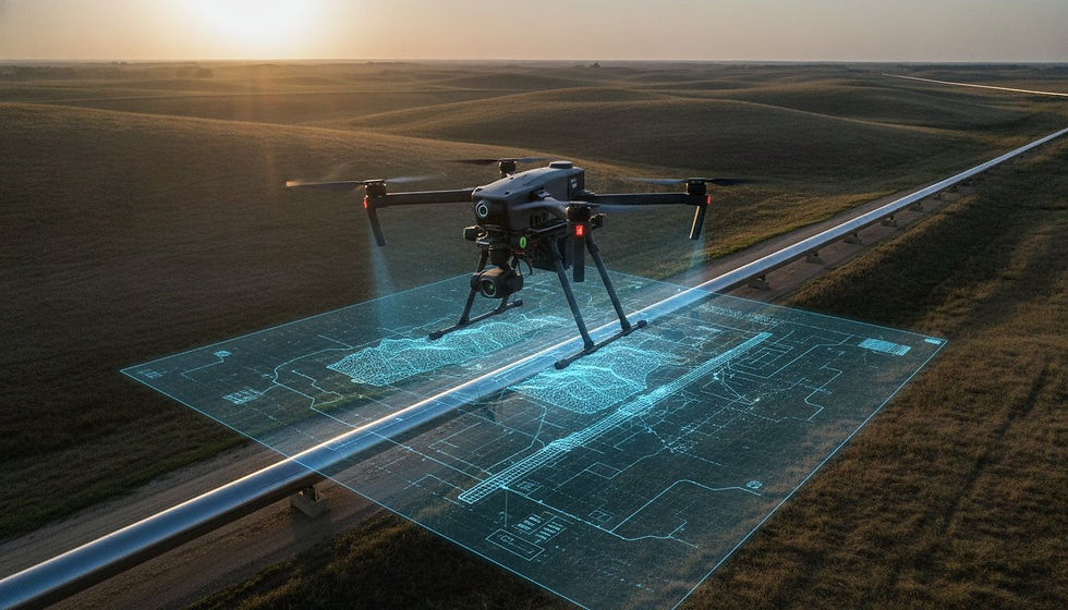
The following analysis demonstrates the transformation of raw aerial data into high-fidelity, predictive intelligence for national enterprise operations. It provides a technical overview of how automated feature extraction and the seamless integration of LiDAR and photogrammetry into digital twins generate a comprehensive oversight mechanism. Readers will understand the methodologies used to establish predictive maintenance capabilities, ensuring that geospatial data serves as a force multiplier for large-scale industrial applications. It's a shift that prioritizes the systematic conversion of complex environmental variables into precise, data-driven results for technical decision-makers.
Key Takeaways
Transition from static descriptive mapping to a predictive intelligence model for enhanced operational foresight and strategic asset management.
Leverage AI-driven geospatial analytics to automate the detection of structural anomalies within complex utility and facade inspection workflows.
Synchronize high-fidelity LiDAR and photogrammetry data into live digital twins for real-time asset monitoring and high-stakes simulation.
Utilize temporal AI algorithms to conduct predictive erosion monitoring and mitigate environmental risks to critical national infrastructure.
Establish high-performance data pipelines that ensure seamless interoperability between autonomous aerial fleets and enterprise cloud architectures.
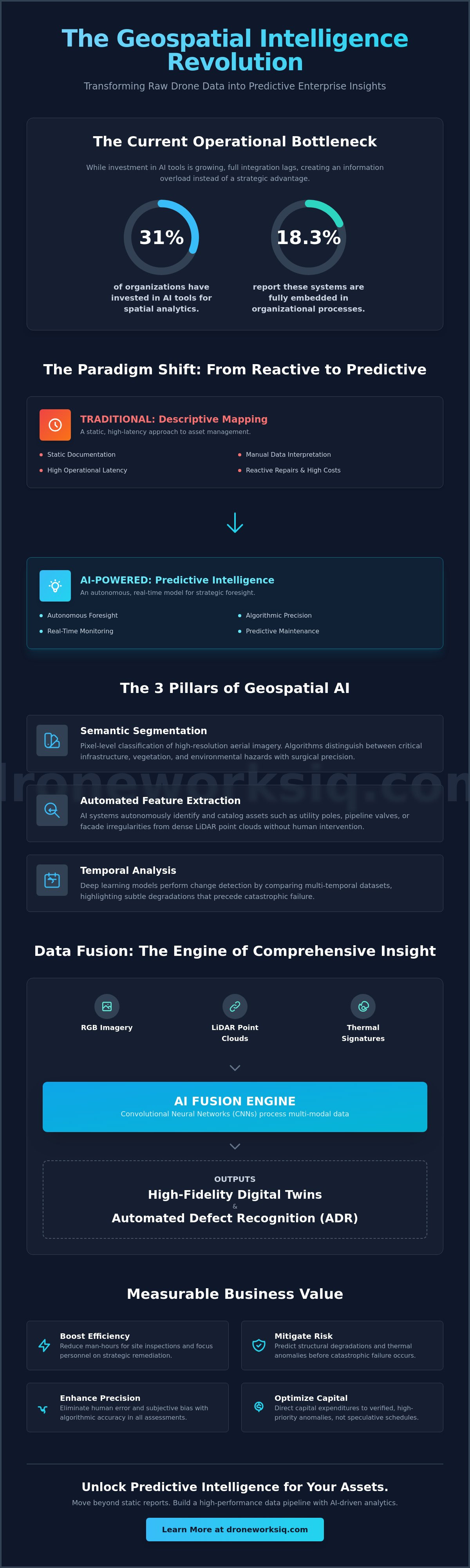
The Paradigm Shift: From Descriptive Mapping to AI-Driven Predictive Intelligence
The evolution of infrastructure management is defined by a transition from static documentation to autonomous foresight. While traditional GIS frameworks focused on the static documentation of existing conditions, AI-driven geospatial analytics introduces a dynamic layer of computer vision and deep learning to the spatial data stack. This convergence is often described as the GEOINT Singularity, a state where the volume and velocity of remote sensing data, processed through autonomous algorithms, provide a continuous and near-instantaneous understanding of global activity. By fusing computer vision with multi-modal spatial data, enterprises can finally transcend the limitations of manual data interpretation.
Traditional photogrammetry services often fail in high-velocity enterprise environments due to the inherent latency of manual data interpretation. When human analysts must manually identify structural anomalies or measure volumetric changes, the resulting intelligence is frequently outdated by the time it reaches decision-makers. AI-driven geospatial analytics eliminates this friction by automating the identification of patterns within massive datasets, effectively reducing operational uncertainty. High-resolution aerial intelligence allows for a proactive stance, where infrastructure management moves beyond reactive repairs to a model of high-fidelity predictive maintenance. It's a shift that prioritizes algorithmic precision over human estimation.
Defining the Core Components of Geospatial AI
The technical architecture of modern geospatial intelligence relies on three primary computational pillars that transform raw data into intelligence:
Semantic Segmentation: This process involves the pixel-level classification of high-resolution aerial imagery, allowing algorithms to distinguish between critical infrastructure components, vegetation, and environmental hazards with surgical precision.
Automated Feature Extraction: By processing dense LiDAR point clouds, AI systems can autonomously identify and catalog assets such as utility poles, pipeline valves, or facade irregularities without human intervention.
Temporal Analysis: Deep learning models perform change detection across national asset footprints by comparing multi-temporal datasets, highlighting subtle degradations that precede catastrophic failure.
The Business Value of Geospatial Transformation
The deployment of autonomous analytical frameworks yields measurable improvements in industrial efficiency. Automating the data pipeline significantly reduces the man-hours required for manual site inspections, allowing specialized personnel to focus on high-level strategic remediation rather than raw data processing. In sectors like construction intel and stockpile monitoring, AI-driven volumetric analysis provides a level of precision that manual surveys cannot replicate. The systematic nature of machine learning mitigates the risks of human error and subjective bias in complex infrastructure assessments, ensuring that every data point is validated against rigorous, clinical standards. This precision ensures that capital expenditures are directed toward verified high-priority anomalies rather than speculative maintenance schedules.
This commitment to data-driven rigor is also transforming the healthcare sector; for instance, physicians can visit Empwr Medical to utilize specialized analytical tools for understanding their true economic value within their organizations.
Neural Networks and Computer Vision: The Engine of Geospatial Data Transformation
The operational core of AI-driven geospatial analytics is the Convolutional Neural Network (CNN). These architectures enable the autonomous interpretation of pixel-level data, transforming raw captures into structured intelligence. By fusing multi-modal datasets, including LiDAR, thermal, and RGB imagery, systems generate a multi-dimensional view of industrial assets. This fusion is critical for Automated Defect Recognition (ADR) in utility and pipeline monitoring, where the correlation of thermal signatures with visual structural anomalies prevents catastrophic failures. It's a technical necessity for modern infrastructure oversight.
Specialized industrial contexts demand high-fidelity training data to ensure model accuracy. Without rigorous data governance, AI systems risk producing false negatives in high-stakes environments. Addressing the Critical Challenges of GeoAI is vital for enterprises that must comply with the data governance requirements of the EU AI Act, which becomes applicable in August 2026. This regulatory landscape emphasizes transparency and auditability in high-risk geospatial applications, ensuring that automated decisions are both explainable and reliable for corporate stakeholders.
Computer Vision in Infrastructure Inspection
Computer vision algorithms excel at identifying hairline fractures in concrete structures that are often invisible to the naked eye during standard inspections. In electrical grid infrastructure, thermal anomaly detection identifies overheating components before they trigger circuit failures. Vegetation management also benefits from AI-driven encroachment analysis, where algorithms calculate the precise distance between utility corridors and growing flora. These automated workflows ensure that maintenance teams prioritize the most critical risks. For comprehensive structural assessments, integrating facade inspection services into a broader digital twin strategy provides a centralized, authoritative view of asset health.
LiDAR and Point Cloud AI Processing
Processing dense LiDAR point clouds requires sophisticated AI to manage the sheer volume of spatial data. Automated classification algorithms distinguish between ground and non-ground points, enabling the extraction of accurate digital terrain models (DTM) even through dense forest canopies. This capability is essential for erosion monitoring and pipeline routing. Beyond simple classification, AI-driven geospatial analytics optimizes 3D digital twin models by cleaning noise and filling occlusions within the point cloud. The result is a high-fidelity representation of the physical environment that serves as a reliable foundation for predictive simulations and long-term infrastructure planning.
Strategic Trends in Geospatial AI: Predictive Maintenance and Digital Twinning
The current trajectory of industrial oversight is defined by the emergence of "Live" Digital Twins, where real-time synchronization with aerial data replaces intermittent manual updates. This advancement relies on the continuous application of AI-driven geospatial analytics to maintain a high-fidelity mirror of physical assets. By integrating edge computing, enterprises now facilitate immediate on-site data processing, reducing the latency inherent in traditional cloud-only pipelines. It's an architectural shift that allows for the instantaneous validation of structural integrity and environmental conditions, providing a level of operational responsiveness previously unattainable in national infrastructure management.
Predictive erosion monitoring represents another critical evolution in the application of temporal AI. By analyzing multi-year datasets, algorithms forecast coastal and site changes with clinical accuracy, allowing for the quantification of erosion rates necessary for national environmental compliance. For those interested in how these environmental factors affect high-value real estate, you can visit Coulee Land Company to learn more about Mississippi River waterfront property in Wisconsin. Similarly, autonomous agri-health mapping has transitioned from basic NDVI assessments to plant-level prescriptive analytics. This granular approach identifies specific physiological stress markers, enabling targeted remediation strategies that optimize yield and minimize resource expenditure. These methodologies represent the intersection of advanced technology and strategic industrial application.
Digital Twins for Lifecycle Management
Modern lifecycle management requires the integration of Building Information Modeling (BIM) with as-built drone data. This comparison highlights discrepancies between design intent and physical execution, mitigating the risks of costly reconstruction. Virtual walkthroughs facilitate remote stakeholder inspections, providing an authoritative visual record that eliminates the need for frequent site travel. AI models now simulate environmental stress on infrastructure, predicting how assets will respond to extreme weather events or long-term structural fatigue. This simulation-based approach is foundational for high-stakes infrastructure intelligence.
Advanced Environmental and Agricultural Analytics
The precision of hyperspectral AI analysis allows for early-stage crop stress detection, identifying nutrient deficiencies or pathogen incursions before visible symptoms manifest. These workflows are essential for large-scale agricultural operations seeking to maximize efficiency. Beyond agriculture, automated carbon sequestration reporting has become a requirement for ESG compliance. By utilizing AI-driven geospatial analytics to measure biomass and land-use changes, organizations generate auditable reports that meet the rigorous standards of the 2026 regulatory environment, including the Colorado AI Act and the EU AI Act.
Architectural Integration: Deploying AI Analytics within Enterprise Systems
Successful enterprise deployment of AI-driven geospatial analytics necessitates a robust architectural framework that extends beyond simple software installation. Organizations must establish a high-performance data pipeline capable of managing the extreme volume, velocity, and variety of aerial intelligence. This process begins with the standardization of raw data formats to facilitate automated ingestion into cloud-based analytical environments. Given that cloud deployment accounted for 63.5% of the North American geospatial analytics market in 2025, the transition toward cloud-native processing is a technical imperative for achieving the scalability required by national enterprise operations. Precision is non-negotiable.
Security protocols must align with the evolving regulatory landscape of 2026. High-risk geospatial AI systems are now subject to the EU AI Act, which became applicable on August 2, 2026. These regulations impose strict requirements for data governance, transparency, and auditability. Businesses operating within North America must also navigate evolving national and regional cybersecurity audit requirements and data breach notification laws. Protecting sensitive national infrastructure data requires a multi-layered security approach. This often necessitates a hybrid model where sensitive processing occurs on-premise while leveraging cloud elasticity for non-classified analytical tasks. It's a complex balance.
The Geospatial Data Pipeline
A functional pipeline automates the transition from drone fleet capture to actionable cloud analytics. Standardizing raw sensor data, including LiDAR point clouds and multispectral imagery, ensures that automated feature extraction algorithms operate with consistent accuracy. Managing the massive data throughput from large-scale aerial surveys requires sophisticated orchestration tools that prioritize processing based on mission criticality. Establishing a human-in-the-loop (HITL) feedback mechanism is essential for continuous model refinement. Technical experts validate algorithmic outputs to improve future predictive accuracy. This ensures reliability.
Interoperability with Legacy Systems
Maximized ROI is achieved when AI-derived insights are integrated directly into existing Enterprise Resource Planning (ERP) and Asset Management software. An API-first approach ensures that geospatial intelligence isn't siloed but serves as a foundational data layer across the organization. Visualizing these complex datasets through custom dashboards allows C-suite decision-makers to monitor national asset health without requiring deep technical expertise in GIS. This interoperability transforms raw spatial data into a strategic asset for long-term capital planning and risk mitigation. To begin the integration process, enterprises should evaluate digital twinning services as a primary interface for infrastructure intelligence.
DroneWorksIQ: Advanced Analytical Frameworks for National Infrastructure
DroneWorksIQ functions as the primary bridge between complex hardware deployment and the generation of actionable AI insights. While many entities focus exclusively on raw data capture, our methodology prioritizes the systematic processing of spatial data through a proprietary AI-driven geospatial analytics workflow. This architecture ensures that information collected via LiDAR data collection and analysis or drone mapping and photogrammetry services is not merely stored but actively utilized to mitigate operational risk. By providing a unified framework for national enterprise clients, DroneWorksIQ eliminates the fragmentation typically associated with large-scale geospatial projects. Precision is the baseline for every engagement.
Case studies in national utility and pipeline inspection services demonstrate the efficacy of this approach. In high-stakes environments, the ability to identify structural anomalies autonomously allows for the prioritization of maintenance schedules across thousands of miles of infrastructure. Similarly, our facade inspection services utilize advanced computer vision to detect hairline fractures and moisture ingress that traditional manual methods often overlook. These applications represent a shift toward a more clinical, data-centric model of infrastructure management where every pixel contributes to a broader understanding of asset health. It's a professional standard designed for corporate accountability.
Specialized Mission Execution
Executing complex missions across diverse industrial landscapes requires a sophisticated sensor suite and a clinical approach to data acquisition. DroneWorksIQ deploys advanced LiDAR and thermal sensors to ensure the capture of high-density point clouds and precise thermal signatures. This focus on specialized mission execution guarantees sub-centimeter accuracy for critical infrastructure projects, providing the necessary foundation for high-fidelity digital twinning services. Our national reach allows for the rapid deployment of these technical capabilities, ensuring that large-scale enterprise operations maintain comprehensive oversight of their physical asset footprints without the latency of traditional surveying methods.
Actionable Intelligence Delivery
The value of aerial data is realized only when raw pixels are transformed into structured health reports and strategic consulting insights. DroneWorksIQ specializes in this transformation, providing technical decision-makers with the clarity required for long-term asset lifecycle optimization. Our construction intel services provide an authoritative temporal record of site progress, while erosion monitoring services offer the predictive foresight needed for environmental compliance. By partnering with a strategic entity focused on high-performance results, enterprises ensure that their AI-driven geospatial analytics implementation serves as a reliable force multiplier for industrial efficiency and risk mitigation.
Advancing National Infrastructure through Autonomous Intelligence
The transition toward autonomous infrastructure intelligence represents a fundamental shift in how national assets are monitored and maintained. By moving beyond static mapping to AI-driven geospatial analytics, enterprises achieve the predictive foresight necessary to mitigate structural failures and environmental risks. The integration of high-fidelity data pipelines and automated feature extraction ensures that complex datasets are transformed into actionable intelligence rather than remaining as raw, unmanageable information. This evolution is critical for organizations navigating the increasingly stringent regulatory and operational demands of the modern industrial landscape.
Establishing a robust geospatial strategy requires a partner capable of executing specialized LiDAR and thermal data collection at scale. DroneWorksIQ provides national deployment capabilities and delivers enterprise-grade AI-driven inspection reports that drive long-term asset optimization. Consult with DroneWorksIQ on your AI-driven geospatial strategy to begin the transition toward a more precise, data-driven operational model. The future of infrastructure management relies on the systematic application of advanced analytical frameworks to ensure sustained reliability and performance.
Frequently Asked Questions
What is AI-driven geospatial analytics?
AI-driven geospatial analytics is the computational process of applying machine learning algorithms to spatial datasets to extract structured intelligence from raw aerial captures. It transcends traditional mapping by using neural networks to identify patterns and anomalies within high-resolution imagery and LiDAR point clouds. This methodology allows for the autonomous classification of environmental variables, providing a foundation for high-fidelity predictive modeling in enterprise-scale infrastructure projects.
How does AI improve the accuracy of drone mapping?
AI improves drone mapping accuracy by automating the feature extraction process and eliminating the subjective bias inherent in manual data interpretation. Neural networks identify and categorize infrastructure components with sub-centimeter precision, ensuring that as-built models align perfectly with design specifications. This algorithmic rigor allows for more precise volumetric calculations and structural health assessments, which are critical for maintaining the integrity of national utility and pipeline networks.
Can AI-driven geospatial analytics integrate with existing GIS software?
AI-driven geospatial analytics is designed to integrate seamlessly with existing GIS software through API-first architectures and standardized data exports. High-performance analytical platforms convert processed intelligence into universally compatible formats such as GeoJSON, LAS, or Shapefiles. This interoperability ensures that AI-derived insights flow directly into legacy Asset Management systems and ERP frameworks, allowing for a unified view of organizational data without requiring the replacement of established software stacks.
What industries benefit most from AI-driven geospatial data?
Industries characterized by large-scale physical assets, such as utilities, construction, and national infrastructure, derive the highest benefit from these analytical frameworks. Utility providers utilize AI for corridor encroachment analysis, while construction firms leverage it for site progress monitoring and volumetric stockpile analysis. Additionally, large-scale agricultural operations use agri-health mapping to optimize yields and manage resource distribution with surgical precision across thousands of acres.
How does LiDAR technology enhance AI-driven inspections?
LiDAR technology enhances AI-driven inspections by providing dense, three-dimensional point clouds that serve as the raw material for automated object recognition. Unlike traditional RGB sensors, LiDAR penetrates dense vegetation to reveal ground-level topography and structural details of hidden assets. AI algorithms process these point clouds to autonomously classify ground vs. non-ground points, facilitating the creation of accurate digital terrain models and high-fidelity digital twins for predictive maintenance.
What is the difference between traditional photogrammetry and AI analytics?
Traditional photogrammetry is a descriptive process focused on creating static 2D or 3D representations of a site, whereas AI analytics is a prescriptive discipline that interprets that data. While photogrammetry provides the map, AI-driven geospatial analytics identifies the defects, predicts future degradation, and suggests remediation strategies. This evolution moves the operational focus from simple visualization to deep, automated analysis, significantly reducing the time between data collection and strategic action.
How does DroneWorksIQ ensure data security for national infrastructure?
DroneWorksIQ ensures data security by implementing rigorous encryption protocols and adhering to the latest international regulatory frameworks, including the EU AI Act of 2026. Our data pipelines are engineered to protect sensitive national infrastructure information through hybrid storage models that balance cloud efficiency with on-premise security requirements. We also maintain strict compliance with evolving US state privacy laws, ensuring that all geospatial data is handled with clinical precision and legal auditability.
What is the ROI of implementing AI-driven geospatial analytics?
The ROI of implementing AI-driven geospatial analytics is realized through a significant reduction in manual inspection man-hours and the prevention of costly infrastructure failures. By identifying structural anomalies before they escalate, organizations shift from expensive reactive repairs to cost-effective predictive maintenance. Automated data processing also accelerates the decision-making cycle, providing a competitive advantage in high-velocity industrial environments where timely intelligence directly influences capital allocation and risk mitigation.