
Stockpile Volume Measurement via Drone Data: An Enterprise Methodology
- Dan

- Jun 2
- 11 min read
Updated: Jun 6
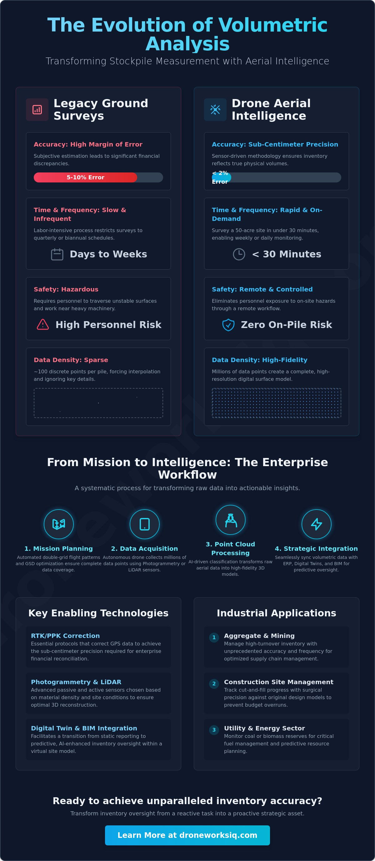
Conventional ground surveys frequently tolerate a margin of error between 5% and 10%, a discrepancy that introduces significant financial instability into enterprise inventory management. You're likely aware that manual surveying remains a hazardous, time-intensive process that fails to meet the demands of modern industrial scaling. Achieving sub-centimeter precision requires a transition from legacy methods to a rigorous, sensor-driven methodology. This guide provides a comprehensive technical framework for implementing high-precision stockpile volume measurement drone workflows designed for industrial environments.
By leveraging advanced LiDAR data collection and photogrammetry, enterprises can reduce data acquisition time for a 50-acre site to under 30 minutes. We'll detail the deployment of autonomous data collection workflows that eliminate human error and ensure seamless integration with existing ERP systems. You'll gain a methodical understanding of how to transform raw aerial data into actionable geospatial intelligence, ensuring your inventory reflects true physical volumes with a margin of error under 2%. This analysis explores the strategic application of RTK-enabled systems and AI-driven point cloud classification to optimize your supply chain oversight.
Key Takeaways
Transitioning to autonomous aerial intelligence eliminates the inherent hazards of manual base-and-rover surveying while drastically reducing data acquisition latency.
Selecting between passive photogrammetry and active LiDAR sensors requires a clinical analysis of material density and environmental constraints to ensure optimal 3D reconstruction.
Implementing RTK and PPK correction protocols is essential for a stockpile volume measurement drone mission to achieve the sub-centimeter precision necessary for enterprise financial reconciliation.
Mastering mission-specific parameters, including automated double-grid patterns and Ground Sampling Distance (GSD), ensures the integrity of high-fidelity volumetric datasets.
Integrating aerial geospatial data into Digital Twins and BIM environments facilitates a transition from static reporting to predictive, AI-enhanced inventory oversight.
Table of Contents
The Evolution of Volumetric Analysis: From Manual Surveys to Aerial Intelligence
Legacy volumetric protocols rely on base-and-rover surveying, a method that introduces unacceptable latency and data sparsity in high-output industrial contexts. The traditional reliance on a few dozen discrete points forces an interpolation of the stockpile surface that frequently ignores significant topographical variations. This subjective estimation results in inventory discrepancies that compromise financial integrity. By utilizing a stockpile volume measurement drone, enterprises mitigate the high-risk necessity for personnel to traverse unstable material surfaces. This transition eliminates exposure to topographical hazards and machinery interference, centralizing data acquisition within a controlled, remote workflow.
The frequency of data collection represents another critical shift. Traditional manual audits are typically restricted to quarterly or biannual schedules due to their labor-intensive nature. Aerial intelligence facilitates a move toward weekly or even daily monitoring, providing a real-time pulse on inventory levels. This transformation from subjective estimation to objective, sensor-driven volumetric calculation ensures that supply chain decisions are based on empirical evidence rather than historical approximations.
Traditional Surveying vs. UAV Volumetrics
A comparative analysis of data density reveals the limitations of ground-based methods. While a manual survey might capture 100 points across a large pile, a single drone flight generates millions of points, creating a high-fidelity digital surface model. High-resolution 3D reconstruction via photogrammetry provides the requisite detail for sub-centimeter volumetric precision. This density directly correlates with labor cost reduction and enhanced operational efficiency in large-scale infrastructure projects. Furthermore, the digital nature of the output supports standardized reporting formats, which are essential for maintaining enterprise-level financial compliance and audit readiness.
Industrial Applications for Drone-Based Measurement
Aggregate and mining operations leverage these systems to manage high-turnover inventory with unprecedented accuracy. In construction site management, our Construction Intel services allow project leads to track cut-and-fill progress against original design models with surgical precision. The utility and energy sectors also rely on this technology to monitor coal or biomass reserves for fuel management. Implementing a stockpile volume measurement drone strategy transforms inventory oversight from a reactive, error-prone task into a proactive strategic asset, ensuring that high-stakes resource management is backed by rigorous geospatial data.
Technical Modalities: Photogrammetry vs. LiDAR for Stockpile Calculation
Selecting the appropriate sensor modality is the primary determinant of data integrity in a stockpile volume measurement drone operation. It's the technical foundation of the mission. While consumer-grade platforms often rely exclusively on passive imaging, enterprise-grade analysis requires a strategic choice between photogrammetry and LiDAR based on material characteristics and environmental variables. High-density point clouds are the requirement for volumetric precision. The ability of a sensor to capture granular topographical detail on irregular surfaces directly influences the reliability of the resulting digital surface model (DSM).
Point cloud density serves as the critical metric for calculating irregular surface volumes. Traditional ground methods provide sparse data, but aerial sensors capture millions of points, allowing for a more faithful representation of the stockpile's actual geometry. This density is particularly vital for piles with steep slopes or deep depressions where interpolation from fewer points would lead to significant volumetric errors. Our technical approach prioritizes the collection of high-density datasets to ensure that the calculated volumes reflect physical reality with surgical accuracy.
When to Deploy Photogrammetry
Photogrammetry remains a robust, cost-effective solution for inventory environments containing well-defined, textured materials like coarse aggregate or crushed stone. This modality relies on high-resolution RGB imagery and significant overlap, typically 80% frontal and 70% side, to facilitate 3D reconstruction. Optimal solar positioning is critical to minimize shadow artifacts that can obscure surface detail and introduce volumetric noise. Post-processing these 2D datasets into orthomosaics and DSMs requires high computational overhead but delivers exceptional visual clarity. For projects where visual context is as valuable as the measurement itself, our Drone Mapping and Photogrammetry Services provide the necessary high-fidelity outputs.
The LiDAR Advantage for Complex Inventories
LiDAR (Light Detection and Ranging) utilizes active laser pulses to achieve direct distance measurement, bypassing the limitations of passive optical sensors. This technology is indispensable when analyzing uniform, dark, or low-texture materials such as coal, sand, or fine dust, where photogrammetric algorithms often fail to find tie points. A recent UAV stockpile volume accuracy study highlights the superior performance of active sensors on steep-sloped piles and in environments with high particulate interference. LiDAR penetrates dust and operates effectively in low-light conditions, ensuring mission continuity when visual sensors are compromised.
By utilizing active pulse measurement, LiDAR eliminates the "blanket" effect seen in photogrammetry on monochromatic surfaces, capturing the true geometry of the stockpile. This approach facilitates a volumetric accuracy of 1-3% compared to traditional ground-based methods, even on complex surfaces. For enterprises managing volatile or complex inventory, our specialized LiDAR Data Collection and Analysis ensures survey-grade precision regardless of material reflectivity.
Ensuring Geospatial Precision: RTK, PPK, and Data Integrity
Precision in volumetric analysis depends on the clinical distinction between relative and absolute accuracy. Relative accuracy ensures the internal geometry of the stockpile is consistent, allowing for precise measurements of the pile's shape. Absolute accuracy anchors the dataset to a specific global coordinate system, a requirement for aligning current data with historical surveys or site plans. For an enterprise-level stockpile volume measurement drone mission, absolute accuracy is non-negotiable. Achieving this level of precision requires sophisticated geospatial correction frameworks that mitigate the inherent drift of standard GNSS receivers, which can otherwise deviate by several meters.
The implementation of high-fidelity sensors must be paired with rigorous validation protocols. Without these, the resulting data is merely a visual approximation rather than a survey-grade asset. We utilize a combination of hardware-based corrections and terrestrial benchmarks to ensure that the final volumetric output is both repeatable and defensible during financial audits. This methodical approach to data integrity transforms raw aerial captures into reliable infrastructure intelligence.
Geospatial Correction Frameworks
RTK-enabled drones communicate directly with localized base stations or Virtual Reference Station (VRS) networks to eliminate the multi-meter drift common in consumer GNSS systems. This active communication loop ensures that every point in a LiDAR return or pixel in an orthomosaic is georeferenced with surgical precision. Statistical validation across industrial sites demonstrates that these protocols maintain volumetric error margins within a 1-3% range compared to traditional ground methods. Z-axis error represents the vertical deviation in geospatial positioning, where even a few centimeters of variance can exponentially inflate or deflate the final volumetric calculation across a large surface area.
Data Validation and Quality Assurance
The integrity of a digital surface model (DSM) is verified through the use of independent checkpoints. These are known coordinates not utilized during the initial data processing phase, serving as an objective benchmark for the final dataset. Effective quality assurance also requires the methodical mitigation of 'noise' within point clouds, such as dust plumes, vegetation, or active machinery, which can lead to significant volume overestimation if not properly filtered. Standardizing on coordinate systems like NAD83 or UTM is essential for multi-site enterprise reporting, allowing for seamless data aggregation across diverse geographic regions. Our LiDAR Data Collection and Analysis workflows incorporate these validation steps to ensure that every report meets the highest standards of geospatial accountability.
The Enterprise Workflow: From Mission Planning to Volumetric Reporting
The transition from field acquisition to boardroom reporting requires a systematic enterprise workflow that prioritizes data integrity at every stage. Successful implementation of a stockpile volume measurement drone strategy begins with rigorous automated mission planning. We utilize sophisticated flight software to design optimized flight paths, typically favoring double-grid patterns over simple linear grids to ensure comprehensive coverage of vertical faces and complex crests. This high-overlap approach is essential for achieving the Ground Sampling Distance (GSD) required for sub-centimeter topographical detail. By managing altitude and sensor parameters, a single drone can capture data for a 50-acre site in under 30 minutes, providing a data density that traditional ground crews can't replicate.
Once data acquisition is complete, raw datasets undergo cloud-based processing to transform millions of points into high-fidelity 3D mesh models and digital surface models (DSMs). The calculation phase requires the precise definition of base planes, whether flat, sloped, or custom-contoured, to account for the underlying terrain. This level of technical control ensures that volumetric accuracy remains within the 1-3% range, a significant improvement over the 5-10% error margins common in manual surveys.
Autonomous Mission Execution
Operational safety and regulatory compliance are the cornerstones of the acquisition phase. All missions adhere to FAA Part 107 protocols, establishing strict safety perimeters and airspace oversight before deployment. During the flight, camera angles are strategically varied; while nadir imagery captures the majority of the surface, oblique shots are critical for defining the stockpile toe and crest with surgical precision. Environmental monitoring systems track wind speeds and light thresholds in real time, ensuring that data consistency isn't compromised by motion blur or excessive shadowing. This methodical control of the data collection environment is what separates industrial-grade analysis from casual aerial photography.
Extracting Volumetric Intelligence
Sophisticated AI-driven analytics facilitate the identification and removal of obstructions, such as conveyors and heavy machinery, which would otherwise skew the volumetric results. Converting these digital volumes into actionable mass estimates involves applying specific material density factors, allowing for the transformation of cubic yards into tons for precise inventory reconciliation. The workflow culminates in the generation of automated PDF and CSV reports that integrate directly with enterprise resource planning (ERP) systems. For organizations seeking to digitize their inventory management with this level of technical rigor, our Construction Intel services provide the end-to-end oversight necessary for high-stakes industrial operations.
Strategic Integration: Transforming Data into Infrastructure Intelligence
The integration of stockpile volume measurement drone datasets into a broader geospatial ecosystem represents the final stage of industrial digital transformation. Modern infrastructure intelligence requires the transition from static, isolated reports to dynamic, multi-dimensional models that facilitate real-time decision-making. By centralizing multi-site volumetric data, executive leadership gains a transparent, singular source of truth for inventory levels, reducing the financial risk associated with material discrepancies. This high-level oversight is critical for large-scale operations where supply chain volatility can impact bottom-line profitability. Our approach leverages specialized data collection and autonomous analytics to ensure that every measurement is a strategic asset rather than a mere point in time.
The centralization of this data allows for the identification of trends across diverse geographic regions, enabling predictive inventory management. This systematic oversight ensures that procurement and logistics teams operate with empirical confidence. Moving beyond basic calculation, the focus shifts to comprehensive infrastructure intelligence, where geospatial precision informs high-stakes operational strategies.
Digital Twins and Asset Management
Building a robust digital twin environment requires the continuous ingestion of high-fidelity aerial data. Visualizing site progress through time-series 3D models allows project managers to identify topographical changes and inventory depletion rates with surgical precision. This 4D data environment facilitates the seamless integration of volumetric datasets with enterprise ERP systems like SAP or Oracle, automating the reconciliation process. Such integration enhances audit transparency by providing immutable, georeferenced aerial records that stand up to rigorous regulatory scrutiny. Our Digital Twinning Services provide the technical framework necessary to maintain these complex, high-stakes data environments with methodical accuracy.
The Future of Autonomous Inventory Oversight
The evolution of autonomous systems is driven by the application of AI-driven analytics for automatic feature extraction and material classification. These systems identify material types and detect anomalies without manual intervention, streamlining the workflow from acquisition to insight. For many enterprises, the total cost of ownership (TCO) of maintaining internal drone programs is often prohibitive. Outsourcing these requirements to specialized partners reduces overhead while ensuring access to the latest LiDAR and photogrammetry advancements. This strategic shift allows organizations to focus on core operations while maintaining a high-performance data pipeline. You can optimize your inventory intelligence with DroneWorksIQ's specialized mapping services to ensure your geospatial missions deliver maximum strategic value.
Advancing Industrial Inventory via Geospatial Intelligence
The adoption of a rigorous stockpile volume measurement drone methodology is the definitive solution for eliminating inventory discrepancies and operational hazards. This technical framework replaces sparse, manual datasets with millions of georeferenced points, ensuring that every volumetric report reflects physical reality with survey-grade precision. By leveraging advanced LiDAR and photogrammetry capabilities, your organization can move beyond static audits toward a dynamic, digital-twin-based oversight model. The integration of high-resolution sensors and autonomous data pipelines ensures that your supply chain remains resilient and data-driven.
DroneWorksIQ facilitates this transformation through AI-driven geospatial analytics and a national scale deployment infrastructure designed for high-stakes enterprise assets. Our protocols ensure that Z-axis errors are mitigated and data is standardized for seamless ERP integration, providing the comprehensive oversight required for modern industrial scaling. Achieving this level of technical oversight is a strategic necessity within high-stakes industrial environments. We're ready to help you implement these high-performance workflows across your entire operational footprint to secure your inventory integrity.
Frequently Asked Questions
How accurate are drone stockpile measurements compared to traditional methods?
Aerial surveys achieve volumetric accuracy within 1-3% of physical reality. Traditional ground-based methods often exhibit error margins between 5% and 10% due to sparse data sampling and subjective interpolation. Aerial intelligence utilizes millions of discrete data points to eliminate the topographical approximations common in manual base-and-rover techniques.
Can drones measure volumes of indoor stockpiles or under covers?
Measuring indoor or covered inventory requires specialized collision-avoidance systems and LiDAR sensors that operate independently of GNSS signals. Standard photogrammetry typically fails in these environments due to insufficient lighting and lack of positioning data. Specialized indoor mapping solutions utilize SLAM technology to navigate confined industrial spaces safely.
What is the best drone for stockpile volume measurement?
The optimal platform depends on material characteristics and environmental complexity. For standard aggregate, an RTK-enabled enterprise drone with a mechanical shutter provides sufficient precision. However, for low-texture or dark materials like coal, a LiDAR-equipped industrial platform is the technical requirement to ensure active pulse measurement and data integrity during a stockpile volume measurement drone mission.
How long does it take to get a volumetric report after a drone flight?
Volumetric reporting latency varies based on data processing requirements, but cloud-based platforms typically deliver results within 24 to 48 hours. Rapid-response workflows utilizing videogrammetry can reduce this window to several minutes for preliminary estimates. The total time from flight execution to inventory reconciliation is significantly shorter than traditional ground survey timelines, which often span several days.
Do I need Ground Control Points (GCPs) if my drone has RTK?
While RTK provides high relative precision, GCPs remain the industry standard for validating absolute accuracy and ensuring survey-grade results. Independent checkpoints are essential for verifying the Z-axis alignment of the digital surface model against known coordinates. Utilizing a combination of RTK and localized benchmarks provides the redundancy necessary for defensible financial audits and multi-site consistency.
What file formats are typically provided in an aerial volumetric survey?
Standard deliverables include georeferenced orthomosaics, digital surface models, and high-density point clouds in LAS or LAZ formats. For enterprise integration, volumetric data is exported in CSV or PDF formats containing detailed mass and volume calculations. These formats ensure compatibility with BIM software and specialized Digital Twinning Services for long-term asset management.
Can drone data distinguish between different types of materials in a single pile?
Aerial sensors capture topographical and spectral data but cannot autonomously determine chemical composition. However, AI-driven analytics can classify materials based on visual texture or color signatures when trained on specific site parameters. Manual boundary definition during the processing phase ensures that distinct material volumes within a single contiguous area are calculated as separate inventory items.
How does weather affect the accuracy of drone-based volume measurements?
High winds and precipitation compromise sensor stability and data quality, leading to motion blur or significant point cloud noise. Optimal data acquisition requires dry conditions and wind speeds below 20 mph to maintain flight safety and GSD consistency. Excessive shadowing from low-angle solar positioning can also introduce artifacts into photogrammetric reconstructions, making midday flights preferable for visual sensors.


